'Extremely dangerous' Hurricane Lee powers up to Category 5 strength, with 160-mph winds
Latest updates Friday: Hurricane Lee's winds doubled in a day. Previous coverage below:
⋯
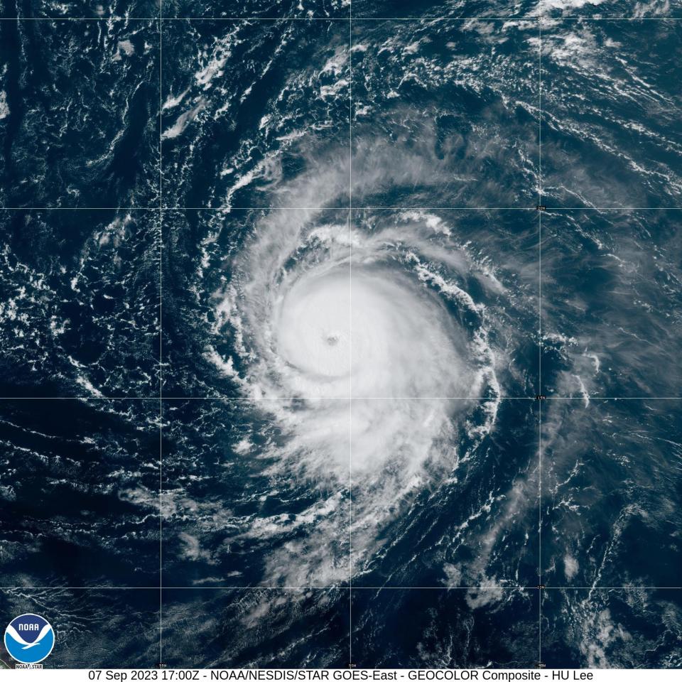
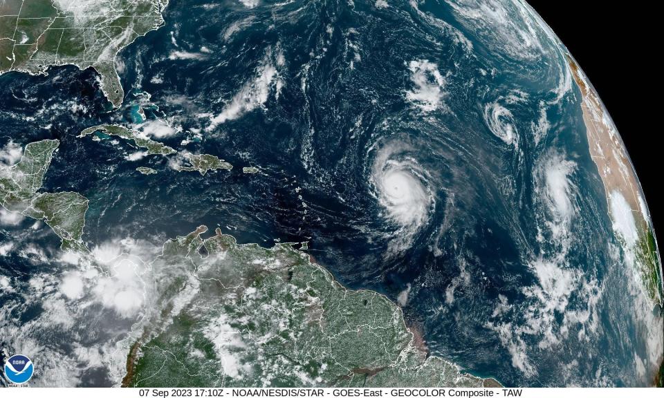
Hurricane Lee roared to Category 5 intensity Thursday far out in the Atlantic Ocean, the National Hurricane Center said.
Lee's winds reached 160 mph by 11 p.m. Thursday, doubling its wind speeds over 24 hours. The powerful hurricane is forecast to strengthen further, reaching winds of 180 mph by Friday morning.
Though still far out at sea, the hurricane center warned that "dangerous surf and rip currents are expected along most of the U.S. East Coast beginning Sunday."
Whether Lee will make landfall or blow out to sea remains a key question.
Meanwhile, the season's 13th named storm – Margot – formed in the Atlantic on Thursday. Just 290 miles west-northwest of the Cabo Verde Islands, it's forecast to become a hurricane over the weekend as it moves north in the Atlantic far away from land.
Rapid intensification to continue
Lee is the fourth hurricane of the 2023 Atlantic season.
Forecasters from the hurricane center, AccuWeather and others accurately predicted Lee would rapidly intensify to a Category 5 strength on Thursday, but its top winds now are expected to peak as much as 15 mph higher than originally forecast earlier in the day.
Lee was one of two Category 5 strength hurricanes being watched by the hurricane center. Hurricane Jova is spinning over the open Pacific Ocean, far from land.
Where is Lee now?
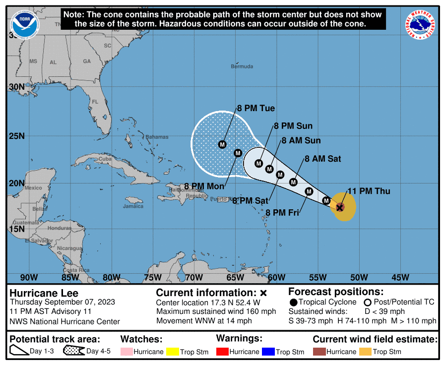
As of 11 p.m. Thursday, Lee was about 700 miles east of the northern Leeward Islands in the northeastern Caribbean, moving to the west-northwest at 14 mph.
"Additional strengthening appears likely, as Lee remains in a low-shear environment and over very warm waters," the center's discussion said.
Long-range forecasts suggest Lee will likely curve north next week before reaching Florida. Potential impacts from Lee along the rest of the U.S. East Coast remain uncertain.
Since 2016, the Atlantic has had 7 Category 5 hurricanes: Matthew in 2016, Irma in 2017, Maria in 2017, Michael in 2018, Dorian in 2019, and Ian in 2022, reported Colorado State University hurricane researcher Phil Klotzbach on X.
Wilma holds the record for rapid intensification
Despite its rapid ascent into such high wind speeds, Lee isn’t the storm to do so fastest in the Atlantic. That record belongs to Hurricane Wilma.
In October 2005, Wilma rocketed from a tropical storm to a Category 5 hurricane in 24 hours, according to the hurricane center’s post-storm report. Wilma also holds the record for the lowest barometric pressure in an Atlantic storm, reaching a low of 882 millibars.
Where is Lee headed? Will it reach the East Coast?
Lee is forecast to move northwest over the open Atlantic Ocean over the next few days.
Beyond that, all major hurricane models that meteorologists use to forecast storms indicate that Lee will curve away from Florida. Looking even further ahead, the latest forecasts suggest Lee's path could vary across a wide swath spanning from the U.S. East Coast northward to eastern Canada, or skirt away from the coast entirely.
"An eventual landfall in the Canadian Maritime provinces or the U.S. East Coast north of Florida is possible after Lee passes Bermuda, as is a recurvature to the northeast, out to sea," said meteorologist Jeff Masters of Yale Climate Connections.
AccuWeather meteorologist Bernie Rayno said, "Right now, the area in the United States that really needs to pay attention includes locations from the Outer Banks of North Carolina up to the Northeast."
Whatever happens, most of the beaches along the eastern United States are likely to see stronger surf and dangerous rip currents next week.
Hurricane center's forecast track for Lee
This forecast track shows the most likely path of the center of the storm. It does not illustrate the full width of the storm or its impacts, and the center of the storm is likely to travel outside the cone up to 33% of the time.
Swells expected to reach the Caribbean
"Swells generated by Lee are expected to reach portions of the Lesser Antilles on Friday, and reach the British and U.S. Virgin Islands, Puerto Rico, Hispaniola, the Bahamas, and Bermuda this weekend," the hurricane center said. "These swells are likely to cause life-threatening surf and rip current conditions."
How is the 2023 Atlantic hurricane season stacking up?
Lee was the 12th named storm to form this season. It's the season's fourth hurricane.
Lee is also the third Category 4 storm this year, following Franklin and Idalia.
An average hurricane season produces 14 named storms and seven hurricanes. Even before the season started, forecasters said 2023 was likely to be a busier-than-normal season, but in August they bumped up their predictions, calling for 14-21 named storms.
Spaghetti models for Hurricane Lee
Special note about spaghetti models: Illustrations include an array of forecast tools and models, and not all are created equal. The hurricane center uses only the top four or five highest-performing models to help make its forecasts.
Hurricane Jova already a Category 5 storm
In the Pacific, Hurricane Jova churned through open waters far from Mexico’s southwest coast as a Category 5 storm. It posed no threat to land.
It was located some 535 miles southwest of the southern tip of Baja California and moving west-northwest at 16 mph with winds up to 160 mph.
Jova underwent rapid intensification over the past day, as the storm's winds increased by a whopping 86 mph in 24 hours from Wednesday to Thursday, AccuWeather reported.
The storm is expected to weaken starting late Thursday.
Contributing: Cheryl McCloud, USA TODAY Network; USA TODAY; The Associated Press
This article originally appeared on USA TODAY: Hurricane Lee reaches Category 5 intensity, with 160-mph winds: Forecast updates

