Hurricane forecasters watching system near East Coast: Millions face 'weekend washout'
Tropical storm conditions are expected to begin Friday along portions of the East Coast, as a low pressure system in the Atlantic Ocean strengthens and is anticipated to become a tropical cyclone.
According to the National Hurricane Center, tropical storm conditions will first begin in North Carolina Friday morning and spread north Saturday. There is a danger of life-threatening storm surge in coastal areas, and high surf and rip currents also are expected through the weekend, along with heavy rainfall across the Mid-Atlantic, from North Carolina to New Jersey.
A tropical storm warning was issued for portions of the East Coast on Thursday as a "potential tropical cyclone" formed in the Atlantic Ocean not far from the southeastern U.S. shoreline.
The current forecast track for the storm indicates it will impact the densely populated I-95 corridor from Washington, DC, to Boston over the weekend. As of Thursday, more than 5 million people faced tropical storm warnings from North Carolina to Delaware.
Meteorologist Maria Torres, a public affairs officer at the hurricane center, said Thursday people along the Atlantic coast need to watch the storm’s progress, gather supplies and make preparations over the next 24 to 48 hours for its arrival.
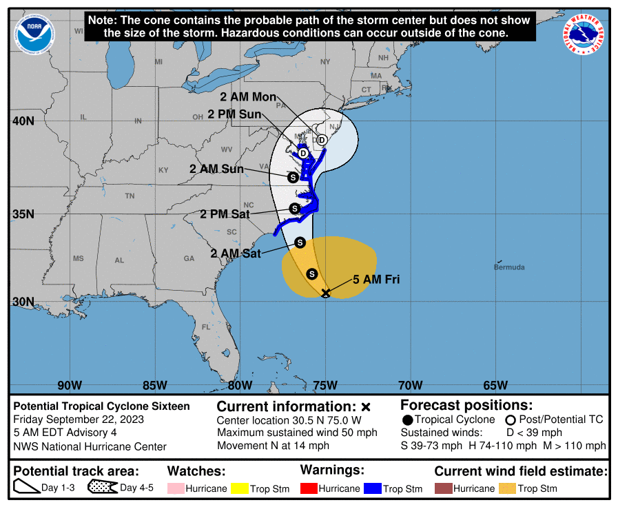
As of Friday morning, the system was located about 330 miles southeast of Charleston, South Carolina, forecasters said, and was moving to the north at 14 mph. Maximum sustained winds were 50 mph.
Tropical – or subtropical – storm is likely
"Confidence is high that the system brewing just off the Atlantic coast will become a tropical or subtropical storm," AccuWeather senior meteorologist Dan Pydynowski said. "A subtropical storm, which has both tropical and non-tropical characteristics associated with it, is most likely due to the structure of the storm."
The hurricane center said the center of the cyclone could reach the North Carolina coast around Friday night and early Saturday.
Tropical storm warning issued
The tropical storm warning is in effect from Cape Fear, North Carolina, to Fenwick Island, Delaware. It also includes the Chesapeake Bay south of North Beach, Tidal Potomac south of Cobb Island and Albemarle and Pamlico Sounds.
Tropical storm conditions are expected within the warning area beginning on Friday and continuing into Saturday.
'Life-threatening' storm surge possible
The combination of a "dangerous" storm surge and the tide will cause normally dry areas near the coast to be flooded by rising waters moving inland from the shoreline, the hurricane center warned.
"There is the potential for life-threatening storm surge inundation from Surf City, North Carolina to Chincoteague, Virginia, the Pamlico and Albemarle Sounds, and the lower Chesapeake Bay," the hurricane center said.
A storm surge of up to 5 feet was possible in some areas.
Drenching downpours, flooding possible
The system will also spread drenching downpours and strong gusts northward along the Atlantic coast from North Carolina to New Jersey, southeastern New York and southern New England late this week and this weekend, AccuWeather said, which said a "weekend washout" is likely for many areas.
The hurricane center said that "heavy rainfall from this system could produce localized urban and small stream flooding impacts across the eastern mid-Atlantic states from North Carolina to New Jersey Friday through Sunday."
Could the storm become Ophelia?
If it officially becomes a tropical or subtropical storm, it would get the name Ophelia. It would be the 16th named storm of the 2023 Atlantic hurricane season, according to Colorado State University hurricane researcher Phil Klotzbach.
What else is out there? What about Hurricane Nigel?
In addition to the system near the Southeast U.S., forecasters were also tracking Hurricane Nigel in the north Atlantic and another developing system off the coast of Africa.
As of late Thursday, Nigel was moving quickly over the open waters of the Atlantic Ocean as a Category 1 hurricane. The hurricane center said Nigel’s maximum sustained winds were 80 mph and the storm was centered about 630 miles east-southeast of Cape Race, Newfoundland, and moving east-northeast at 37 mph.
Forecasters expected Nigel will weaken over the next couple of days. It was forecast to become a post-tropical cyclone on Thursday night.
Elsewhere, a tropical wave off the coast of Africa showed signs of development on Thursday. According to the hurricane center, environmental conditions are forecast to be conducive for gradual development, and a tropical depression is likely to form late this week or this weekend while the system moves generally westward at 10 to 15 mph across the eastern and central tropical Atlantic.
It's too early at this time to determine if there will be any impact to the U.S. or the Caribbean from the tropical wave.

Noaa
Embedded content: https://www.nhc.noaa.gov/xgtwo/two_atl_0d0.png?052051
Contributing: The Associated Press; C.A. Bridges, USA TODAY Network – Florida
This article originally appeared on USA TODAY: NHC forecasts Ophelia will form, storm to impact Washington, NYC

