Grace drops to tropical storm over Yucatan Peninsula. Henri to turn into a Cat 1 soon
Grace, now a tropical storm, made landfall early Thursday along the eastern Yucatan Peninsula just south of Tulum as a category 1 hurricane before weakening back to a tropical storm.
Forecasters are also monitoring Tropical Storm Henri, which is forecast to strengthen into the season’s third hurricane by Friday and could bring life-threatening surf and rip current conditions to the U.S. East Coast through the weekend.
Here’s what to know:
Tropical Storm Henri to turn into Cat 1 hurricane soon, near U.S. coast
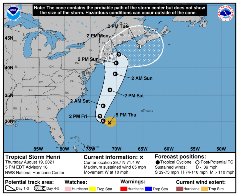
Tropical Storm Henri has slightly deteriorated on its trek across the Atlantic. It was traveling near 10 mph, with maximum sustained winds near 65 mph with higher gusts, according to the National Hurricane Center’s 5 p.m. update.
The storm was about 450 miles south-southeast of Cape Hatteras, North Carolina, and about 800 miles south of Nantucket, Massachusetts, Thursday evening.
Henri is forecast to strengthen into a Category 1 hurricane by Friday over the Atlantic’s warm waters and should be near the U.S. northeastern coast this weekend and early next week, bringing a risk of storm surge, wind and rain to the area.
The storm’s swells, which could cause life-threatening surf and rip current conditions, are also forecast to reach much of the U.S. East Coast by the end of the week and through the weekend. Parts of Canada might also feel Henri this weekend and early next week.
On the forecast track, Henri was moving west and is expected to make a turn toward the northwest on Friday. It should then pick up speed and eventually start moving north-northeast during the weekend.
Henri should remain well offshore of the U.S. East Coast over the next couple of days, and could approach southeastern New England on Sunday as a hurricane before slowly weakening back into a tropical storm as it moves over colder waters, according to the hurricane center.
Grace weakens to tropical storm in Mexico
Hurricane Grace made landfall along the eastern Yucatan Peninsula of Mexico early Thursday as a category 1 storm, just days after it struck several Caribbean islands, including Haiti, which is still recovering from a deadly 7.2 magnitude earthquake.
Grace made landfall near Tulum around 5:45 a.m. and is forecast to bring hurricane and tropical-storm-force winds, heavy rain and dangerous storm surge to the area.
After a few hours over land, Grace had weakened back to a tropical storm with maximum sustained winds of 50 mph, according to the hurricane center’s 5 p.m. update.
Flash and urban flooding are possible across portions of the Yucatan Peninsula and Veracuz, which may also see mudslides, according to the hurricane center.
On the forecast track, Grace should re-strengthen to a hurricane once it emerges over the Bay of Campeche, before it makes its second landfall along the coast of mainland Mexico. It should then weaken back into a tropical depression as it moves over land and eventually dissipates over the country’s mountains.
“The remnants of Grace are expected to emerge over the eastern North Pacific and possibly re-develop there, but the uncertainty of whether this will be the original center or a new center precludes forecast points over the Pacific at this time,” forecasters wrote.

