Hurricane Hilary forecast recalls infamous 1939 storm that killed scores of Californians
Southern California could see a true weather rarity — a tropical storm hitting the coast.
Hurricane Hilary is churning off the coast of Mexico, and current projections show it could reach the Baja California peninsula by late Sunday.
A weakened storm then might move into San Diego and the Los Angeles area, though officials are still not sure of the exact forecast. Forecasters said the region could expect heavy rain and winds Sunday and Monday.
Read more: Could a hurricane lash Los Angeles? 80 years ago, this deadly storm came close
Hilary has brought back memories of another far bigger and more dangerous tropical storm — nicknamed El Cordonazo or the Lash of St. Francis — that hit Long Beach and San Pedro in September 1939.
It was a storm that went into the history books. The Times' Paul Duginski wrote a chronicle in 2019 of the event.
What happened in 1939?
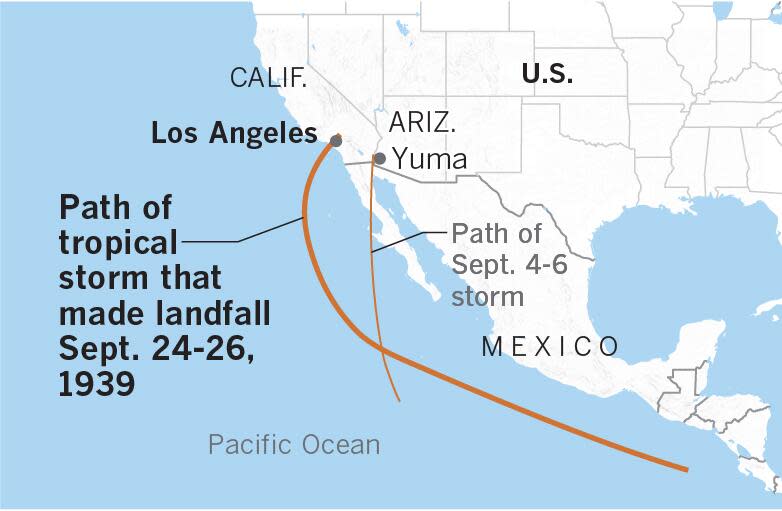
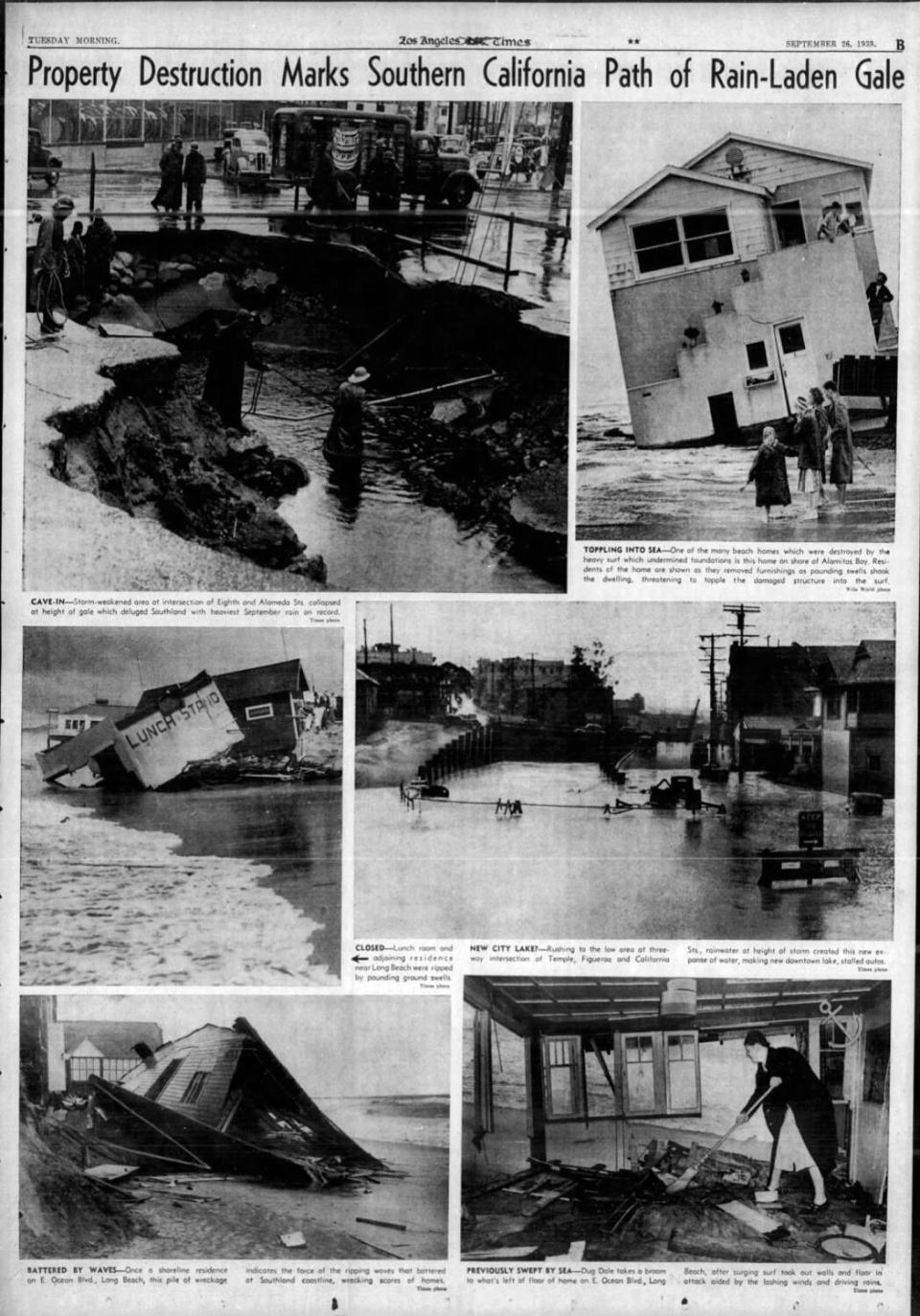
Four major system moved into Southern California, including a tropical storm that came ashore, dropping torrential rain totaling 5.62 inches on Los Angeles from Sept. 24-26.
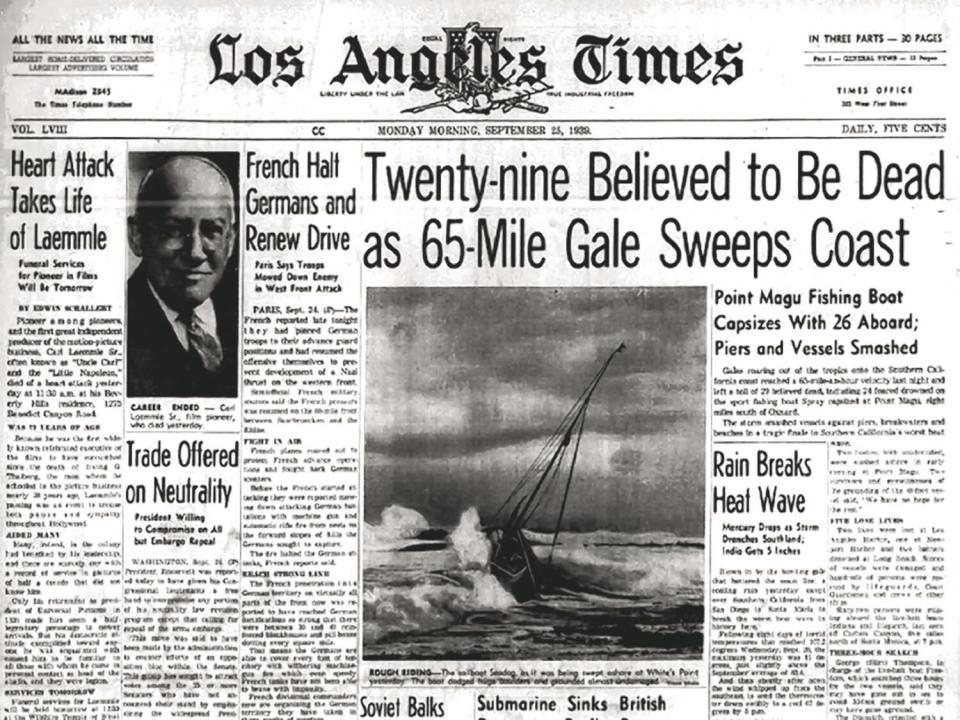
It battered Southern California with wind gusts up to 65 mph, damaging boats, structures, utility lines and crops, according to the Los Angeles Times. Forty-five people were killed by flooding throughout Southern California, and an additional 48 died at sea. It’s the only tropical storm to make landfall in California during the 20th century.
What was the impact?
On Sept. 5, two more tropical cyclones were born about 1,000 miles apart in the warm waters west of Central America. They followed similar paths along the western coast of Mexico, dying out about a week later over central and southern Baja California. But they sent a plume of tropical moisture north into the Colorado Desert, which is part of the Sonoran Desert in southeastern California, southwestern Arizona and northwestern Mexico.
The fourth in that series of storms — what would be a long-lived Cordonazo — formed around Sept. 15 in the waters off Central America and quickly intensified, reaching its lowest pressure of 970.9 millibars on Sept. 22, when it was about 300 miles west-southwest of Cabo San Lucas, Mexico.
As the storm churned northward, Southern California broiled under a torrid heat wave, with a recorded temperature of 107.2 degrees in Los Angeles on Sept. 20.
Read more: Hurricane Hilary is headed toward L.A., San Diego. What to know and how to stay safe
On Sept. 23, the temperature reached 100 degrees at the federal building downtown. About 4:40 p.m., a light rain fell, cooling the city slightly. That same day, a thunderstorm dumped 6.45 inches of rain in six hours on Indio. Moisture from one of the two previous cyclones that had broken up a week earlier south of Ensenada, Mexico, may have fueled that thunderstorm.
Read more: Hurricane Hilary is bearing down on Southern California. What's your flood risk?
After days of intense heat, ominous clouds gathered and thickened over L.A. on the afternoon of Sept. 24 as the fourth tropical storm deteriorated off Santa Catalina Island. The cloud cover pulled the daytime high temperature down to just 81 degrees. A cooling southeasterly breeze arose around noon, lowering the mercury to 67 degrees by 5 p.m. That’s when the rain began. And those cooling southeasterly winds would gust to 50 mph by 7 p.m.
Rain intensified overnight and was especially heavy between 1 a.m. and 8 a.m. on Sept. 25. The rain let up from 10:15 a.m. until 5:35 p.m. that day, then resumed and continued through 1:15 a.m. Sept. 26.
Rainfall amounts were impressive: Long Beach reported 4.51 inches; Claremont, 4.89; the Santa Ana River, 4.41; and Mt. Wilson received 11.60 inches over three days, with 9.02 inches of that falling on Sept. 24.
What was the damage and loss of life?
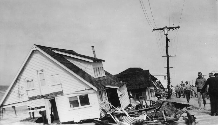
According to reports at the time, scores of people died and parts of the L.A. and Orange County coast were battered.
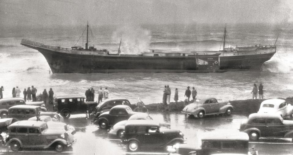
"Four days after its fury had subsided, Southern California's tragic week-end coastal storm yesterday had exacted a toll of 18 persons known to be dead, 30 known to be missing, and approximately 25 others aboard boats still unreported by the United States Coast Guard," The Times reported. "Eight summer homes at Sunset Beach were battered and dragged into the sea by mountainous waves."
Other reports put the death toll in the 40s.
Piers were badly damaged and homes washed away.
According to The Times, “The storm smashed vessels against piers, breakwaters and beaches in a tragic end to Southern California’s worst heat wave.” When it was all over, damage to boats, structures, power and phone lines was extensive, exceeding $1.5 million. Crop damage amounted to $500,000. Half of the San Clemente Pier in southern Orange County was washed away. ($1 million in 1939 is equivalent to nearly $18 million in 2019.)
This story originally appeared in Los Angeles Times.

