How will Hurricane Hilary impact the High Desert?
Batten down the hatches, Hurricane Hilary could soon hit Southern California and the High Desert, which may receive the majority of its annual rainfall in just 48 hours.
Tropical-storm-force winds and heavy rain are expected to arrive Saturday through Monday in the Victor Valley, where temperatures could drop into the 70s, the National Weather Service reported.
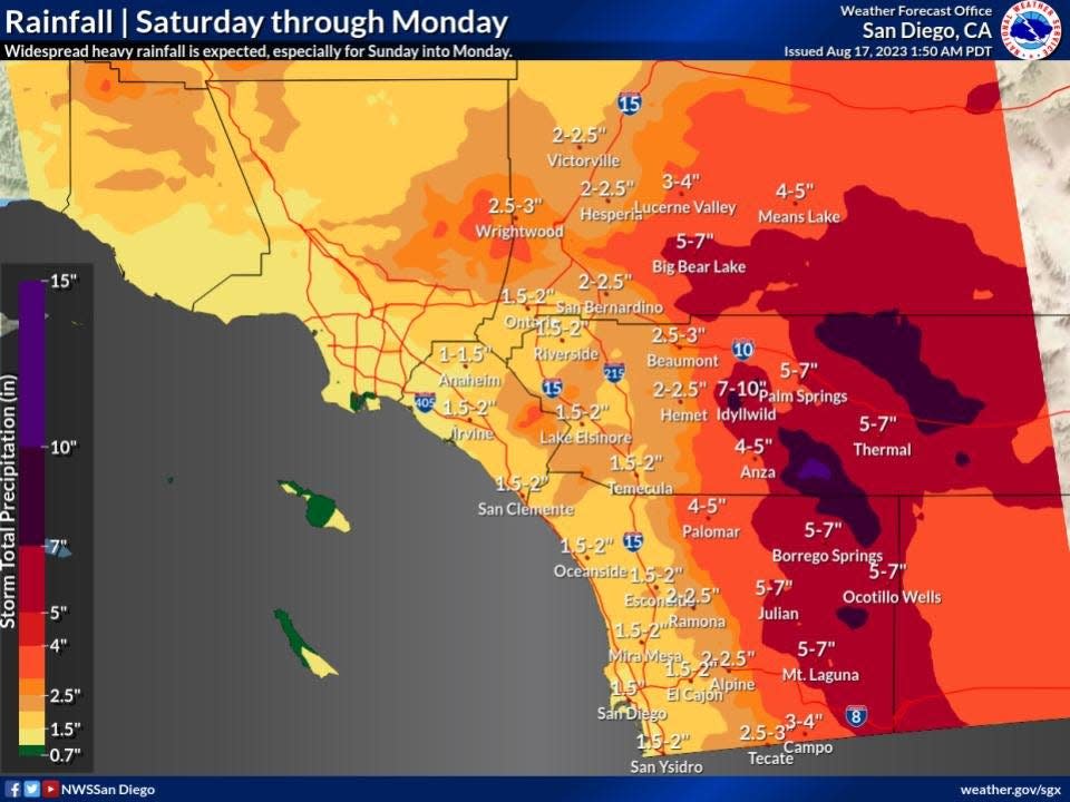
Forecasters estimate 2 to 4 inches of rain in some areas of the Victor Valley and 5 to 7 inches in the San Bernardino Mountains.
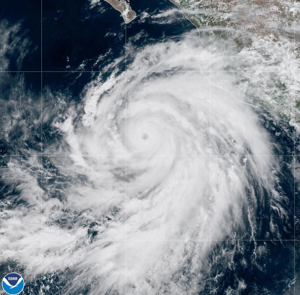
Parts of Southern California were put under a tropical storm watch for the very first time Friday, as Hilary grew to Category 4 strength and was poised to hit the region as a tropical storm as early as Sunday with "significant and rare impacts," including heavy rainfall that could lead to extensive flooding, forecasters said.
Victorville is expected to receive 2.5 inches of rain from Saturday to Monday, which is significant since its average rainfall is approximately 3.9 inches per year.
As the storm moves north, the majority of the rain is expected in the mountains and east of Lucerne Valley, however, the trajectory of the storm could change, forecasters said.
Lucerne Valley, which receives 11 to 14 inches of rain annually is expected to receive 3 to 4 inches during the storm.
Sand bags
Town of Apple Valley spokeswoman Sarah Krieg told the Daily Press that the Apple Valley Fire Protection District has sandbags and sand ready for residents to pick up starting Thursday and throughout the weekend.
Those resources are available at Fire Station 331 at 22400 Headquarters Drive in Apple Valley. The fire chief said sandbags are available during normal business hours but are otherwise subject to the station crew's availability, Krieg said.
The City of Victorville is also offering free sand and bags to help residents protect property from potential flooding. Residents can pick up those resources from any city station. The limit is 10 bags per household. View pick up locations, hours of operation and more at victorvilleca.gov.
Residents should check with their local municipality to see if they may obtain free sandbags.
San Bernardino County Fire officials said the county offers free sandbags and sand, and they strongly urge residents to use them.
County fire stations maintain only a limited supply of sandbags to be used during an emergency and homeowners should not depend on that supply.
#HurricaneHilary will impact #SanBernardinoCounty beginning Sunday through Monday. Flooding is possible throughout the county with an increased risk for residents near the #ElDoradoFire & #AppleFire burn scars.
Get prepared. Sandbags are available now 👉 https://t.co/hl1Wv1tktl https://t.co/27zv1krAlT pic.twitter.com/12EnzMvetI— San Bernardino County Fire (@SBCOUNTYFIRE) August 17, 2023
Flood watch
San Bernardino County Fire officials stated that beginning Sunday through Monday, flooding is possible throughout the county with an increased risk for residents near the El Dorado Fire and Apple Fire burn scars.
A flood watch has been issued for the local mountains and deserts from 11 a.m. Saturday through 5 p.m. Monday.
If Hilary does make landfall in California, it would be the first tropical storm to do so since 1939. Hilary’s eye is expected to make landfall near the southern border around noon on Monday.
Hilary was upgraded from a tropical storm to a hurricane Thursday morning off the coast of Mexico as it continues to "intensify rapidly," meteorologists said.
The hurricane could also potentially bring “significant impacts” to parts of Southwestern U.S. this weekend, including heavy rain, strong winds and flash flooding in the Baja California Peninsula and Southern California, according to the National Hurricane Center.
Cajon Pass and Las Vegas travelers
Those traveling through the Cajon Pass and near Las Vegas should be cautious of heavy rain especially along Interstate 15 between Barstow and Las Vegas where flooding has previously occurred.
The Victor Valley got a sneak peek of the storm's coming attractions on Wednesday afternoon as a burst of rain flooded streets in some areas of Apple Valley and Hesperia.
“It was clear skies in the morning, then it got cloudy in the afternoon,” Carol Vinton told the Daily Press. “We heard thunder, saw a flash of lightning and then our dry backyard became a lake in two minutes. Then it stopped raining and the skies cleared up.”
State response
On Thursday, state officials said they are closely monitoring the development of Hurricane Hilary and working to protect Californians who may be most at risk for the impacts of the storm.
At Gov. Gavin Newsom’s direction, the Office of Emergency Services (Cal OES) is coordinating across state government to support state and local preparations.
Cal OES remains in constant communication with the National Hurricane Center, the National Weather Service, and county emergency management officials in the areas of the state that are in the path of this storm.
The State Operations Center in Mather, California is already actively coordinating an early, unified, and orderly response across state agencies to surge resources to the impacted region in preparation for potential impacts and to support response and recovery efforts in the aftermath of the storm.

Daily Press reporter Rene Ray De La Cruz may be reached at 760-951-6227 or RDeLaCruz@VVDailyPress.com. Follow him on Twitter @DP_ReneDeLaCruz
This article originally appeared on Victorville Daily Press: How will Hurricane Hilary impact the High Desert?

