Hurricane Hilary’s path shifts as it heads north. How will SLO County be impacted?
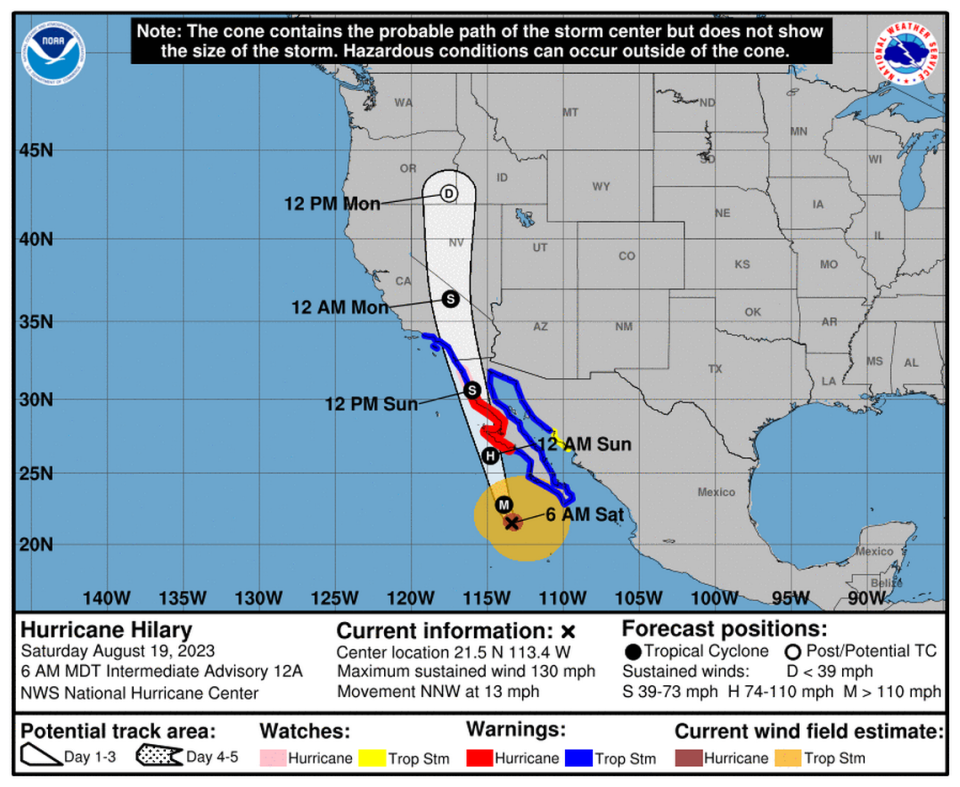
Hurricane Hilary’s path has shifted eastward as it continues charging north toward Southern California.
San Luis Obispo County is expected to see stormy weather beginning on Sunday as a result of the category 3 storm.
Impacts along the Central Coast aren’t expected to be nearly as devastating as those faced by the southern and eastern edges of the state. There, catastrophic flooding and potentially devastating winds may cause widespread damage.
Hurricane Hilary was about 800 miles south-southeast of Los Angeles as of Saturday morning. It had sustained winds between about 111 to 129 mph, according to the National Weather Service.
It’s forecast to hit Southern California beginning Sunday morning, the Weather Service said.
San Luis Obispo County’s weather on Sunday will be a result of far-spread impacts of what is then expected to be a large tropical storm, which is bringing strong winds and lots of warm moisture.
On Sunday after 11 a.m., the Weather Service predicts a chance of thunderstorms for the county. High temperatures are forecast to range from the low 70s in the coastal areas to the low 90s in the inland areas, according to the Weather Service.
It’ll likely be breezy on Sunday, with gusts beginning as high as 25 mph and strengthening as the day moves forward, the Weather Service predicts.
Moving into Sunday evening, the likelihood of thunderstorms increases.
San Luis Obispo County can expect to receive a small amount of rain Sunday evening, totaling about a tenth to a quarter of an inch, according to Saturday forecasts by the Weather Service.
By Monday morning, light showers and continually strong winds with gusts up to 20 mph are expected in the county, according to the Weather Service.
Rain totals aren’t expected to reach past a tenth of an inch, the Weather Service predicts as of Saturday afternoon.
Temperatures may be cooler on Monday, ranging from the high 60s in the coastal areas to low 80s inland, according to the Weather Service.
The thunderstorms may stick around through Monday evening, according to the Weather Service, while sunny skies are expected to return on Tuesday.
Hurricane Hilary is expected to spread heavy rain into the Southwest beginning today, while potentially lasting into Monday. The current rainfall forecast would deliver more rain in a few days to some California desert cities than they typically see in a whole year, on average. pic.twitter.com/NqbZPqriwZ
— NWS Weather Prediction Center (@NWSWPC) August 19, 2023

