Hurricane Hilary rapidly intensifies to Cat 4 storm crawling toward Southern California
A burly Hurricane Hilary is stalking Southern California in a rare show of force in a rare hurricane season unfolding in an atmosphere untamed by customs or climatology.
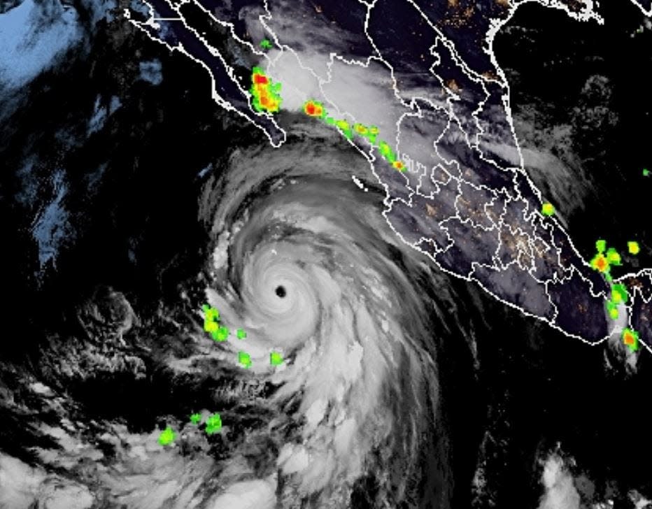
Hilary, a Pacific storm that grew to a 145-mph Category 4 hurricane on Friday in a stunning bout of rapid intensification, comes as the tropical Atlantic is also buzzing with renewed energy.
After a lull with no Atlantic tropical cyclones since far away Don fizzled July 24, the National Hurricane Center was watching four areas of potential development with varying chances of gaining tropical cyclone footing.
South Florida’s lone concern for now is a squish of cloudiness that will add to soggy storms to the forecast Saturday and Sunday. Once it hits the record-warm Gulf of Mexico, the system was given a 40% chance of development into a named storm over seven days.
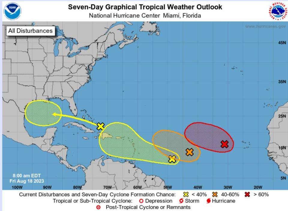
The next names on the Atlantic basin hurricane list are Emily, Franklin and Gert.
George Rizzuto, a meteorologist with the NWS office in Miami, said the tropical wave, which was north of Hispaniola on Friday, could squirt through the Florida Straits or brush over mainland South Florida with the potential of 2 to 3 inches of widespread rainfall in Palm Beach County.
“It’s not a washout at all, but you don’t want to be without your umbrella,” Rizzuto said. “For the most part, the main story will be the unsettled on-and-off rain.”
With the peak of the Atlantic basin hurricane season beginning this weekend — the absolute pinnacle is Sept. 10 — it is not unusual for four areas to be under NHC watch, said Fox Weather hurricane specialist Bryan Norcross.
What is unusual is the overall ensemble of ingredients coming together this season including record-warm waters in the Gulf of Mexico and the Atlantic’s main development region, the burgeoning El Niño, which is just now spreading its wings, the timid Bermuda High, and the remorseless and brutal heat dome over the Central U.S.
More: 2023 hurricane season: Fear rain as much as storm surge as climate change increases threat
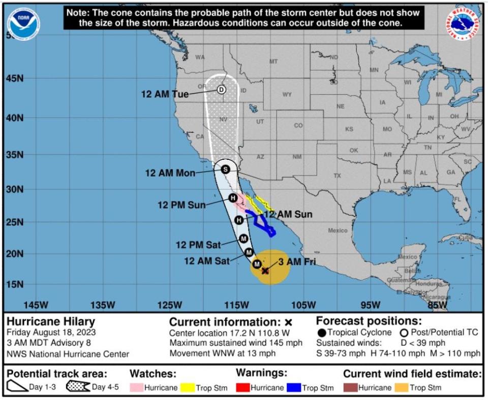
It is the heat dome that is largely steering Hurricane Hilary on a path so odd that the NHC for the first time in its history issued tropical storm watches for areas as far north as Long Beach, California.
In fact, according to the NHC, the last known tropical storm to make landfall in California was September 1939.
“Is something weird and different going to happen this season? That’s still an open question to some degree,” Norcross said. “But the weather pattern causing Hilary to get grafted into Southern California is weird and different.”
Hilary, which was forecast to top out with wind speeds of 150 mph, is floating in a streamline of air between the heat dome and an area of low pressure to its west that Norcross said is more often seen in winter.
By the time Hilary reaches near San Diego, its winds will have stalled over cooler waters, but it is still expected to be a strong tropical storm with 60-mph winds that will mimic the Santa Anas, only wetter.
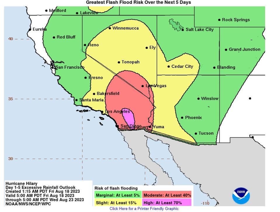
Meteorologists are forecasting up to seven inches of rain in Southern California, something National Hurricane Center experts said could produce flash and urban flooding with “the potential for significant impacts.”
More: NOAA 2023 hurricane season forecast: We really need El Niño to form this year
"It’s very rare to see Southern California placed in the forecast cone for a hurricane, and this large and very wet hurricane poses a rare significant heavy rain threat for the Southwest U.S. early next week,” wrote meteorologists Bob Henson and Jeff Masters in their column for Yale Climate Connections.
Yet, Hilary found itself in near ideal conditions for a burgeoning tropical cyclone with waters near 86 degrees and low wind shear. It was declared a hurricane Thursday morning. By early Friday morning, it had strengthened to a Category 4 storm.
Where Hilary will make landfall is “nearly impossible to predict,” said NHC senior hurricane specialist Robbie Berg in a Friday morning forecast.
Besides a notable historical event, landfall may be irrelevant as the main threat will be from the teeming moisture Hilary hauls into the state, as noted by meteorologist Michael Lowry, a hurricane and storm surge expert with Miami's ABC affiliate Channel 10.
Lowry said in his written forecast that the National Weather Service on Friday issued a first-ever high risk for excessive rainfall for areas east of the mountains and low deserts of Southern California. The Mojave Desert, Joshua Tree National Park and the Anzo-Borrego Desert State Park have a 40% to 70% chance of exceeding flash flood rainfall amounts.
“This should be treated as a serious situation, an unusual situation with the potential of a tropical storm moving right up into Southern California Sunday and Monday,” said San Diego-based meteorologist Alex Tardy in a video forecast.
More: What’s an invest and why do they keep saying tropical cyclone?
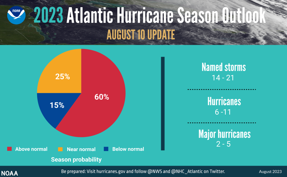
Last week, the National Oceanic and Atmospheric Administration increased its Atlantic seasonal hurricane forecast, doubling its expectations to 60% for a more active season.
With five storms already in the record books for 2023, including an unnamed storm that formed in January, the federal outlook now calls for a total of 14 to 21 named storms, of which six to 11 will become hurricanes. Of the hurricanes, two to five could be major hurricanes of Category 3 or higher.
A normal season has 14 named storms, including seven hurricanes, of which three become major hurricanes.
The challenge this year is the unprecedented combination of record-warm sea surface temperatures, which provide fuel to tropical cyclones, and the emergence of an El Niño climate pattern, which knocks down tropical cyclones.
Matthew Rosencrans, lead seasonal hurricane forecaster for NOAA’s Climate Prediction Center, said a major factor in increasing the likelihood of an above-normal season has been a lack of storm-shredding wind shear from El Niño so far.
It’s so uncommon to see El Niño paired with record warm sea surface temperatures that hurricane experts can find no years in the historical record to mirror 2023, Rosencrans said.
“I only found one good analog year and that was 2004,” Rosencrans said.
There were 15 named storms in 2004, including nine hurricanes. Six of the hurricanes were Category 3 or higher.
In Florida, hurricanes Charley, Frances, Ivan and Jeanne made landfall within a six-week period.
It was nicknamed the Mean Season.
“What’s going to happen in the future is fuzzy,” Norcross said. “We have all this fuel with extremely warm sea surface temperatures. The question is will the atmosphere organize itself in a way that will support strong storms.”
Kimberly Miller is a veteran journalist for The Palm Beach Post, part of the USA Today Network of Florida. She covers real estate and how growth affects South Florida's environment. Subscribe to The Dirt for a weekly real estate roundup. If you have news tips, please send them to kmiller@pbpost.com. Help support our local journalism, subscribe today.
This article originally appeared on Palm Beach Post: Hurricane Hilary now a Cat 4 heading to Southern California

