Hurricane Hilary strengthens on path to Arizona, increasing rain chances
As Hurricane Hilary continues on its path to Arizona, here is what Arizonans need to know to prepare for the impacts of the now Category 3 storm.
Hilary has been growing since Wednesday, when it was found forming off of Mexico's southern Pacific Coast, growing from a Tropical Storm at its inception to now "major" status — a Category 3 plus hurricane — as of Friday morning.
According to Tom Frieders, the Warning Coordination Meteorologist with the National Weather Service, wind speeds were up to 145 mph Friday morning, saying that in the last 24 hours, Hilary has seen "rapid intensification."
Its effects will be mainly felt throughout the Baja California Peninsula and weaken on Saturday as it moves toward the western portion of the Peninsula, encountering cooler waters on its path to the southern California mainland.
Hurricane Hilary updates: Sky Harbor sees flight cancellations, delays
"We're anticipating widespread three to six-inch rainfall totals into southern California, so the counties there of Riverside and Imperial counties in southeast California are going to likely get hit the hardest," Frieders said during a briefing Friday morning.
Frieders also stressed that some western parts of these Golden State counties could receive localized amounts upwards of eight to possibly 10 inches.
"We're monitoring that closely, so areas like Joshua Tree National Park, Box Canyon roadway through there and the western half of Imperial County really seem to be under the gun," Frieders said.
What will Hilary bring to Arizona?
In Arizona, Hilary's effects are already being felt, with increased moisture levels having spurred showers around parts of the state on Thursday. Rain chances are only increasing as well, as Frieders stated strong to severe thunderstorms with concerns of localized damaging winds and flooding would begin in the Grand Canyon state Friday.
"Think of it as a more widespread monsoon event," Frieders said. "We're expecting several rounds of storms, especially across northwest portions of the state."
Greatest impacts from Hurricane Hillary for N. AZ will likely be this afternoon into Saturday, as moisture surging ahead of the storm enhances our monsoon activity. Flash flooding is the greatest threat, particularly across Western AZ. #azwx pic.twitter.com/WaAbyCu2xk
— NWS Flagstaff (@NWSFlagstaff) August 18, 2023
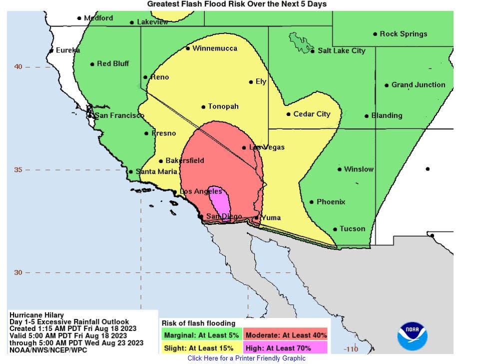
Referencing the map the weather service shared on X, formerly known as Twitter, the area in yellow represents a "slight risk of flash flooding guidance being exceeded within a 15% chance in a 25-mile radius," according to Frieders.
A flood watch throughout Western Coconino County went into effect early Friday morning and will last until 6 a.m. on Saturday. For the other regions, Mohave, La Paz, Yuma, Yavapai and parts of Pima and Santa Cruz counties, flood watches will run till 5 p.m. on Monday, Aug. 21.
The agency included an updated forecast on Friday evening noting that Yuma County up through La Paz and Riverside counties will have greatest risk of flash flooding. The forecast said rainfall could begin in the evening and continue into Saturday morning. It also noted that excessive rain could damage part of Interstate 10, which storms have done in the past.
NWS also introduced a wind advisory for southwest Arizona and southeast California beginning Sunday afternoon through early morning Monday with projected wind speeds between 35-45 mph which could potentially cause power outages from knocked down power lines.
Weekend outlook: Heaviest impacts from Hilary
According to the weather service, Saturday through Sunday will see most of the impact for southwestern Arizona, describing the conditions as "deteriorating" for areas such as Yuma and La Paz County.
"Rain and thunderstorms will become numerous with really heavy downpours, gusty winds and then during that Saturday night Sunday nighttime frame, this is the most intense rain, more persistent rains and gusty winds," Frieders said.
These heavily affected portions along the west-southwestern areas of Arizona have a forecast precipitation of cities near California receiving more than two inches of rain from the storm, with an ever-increasing threat of flash floods.
"Most of the impacts will shift into far western Arizona, but especially southern California once we get into this weekend," Frieders said.
As of Friday, some of those expected totals are:
Yuma: 2.95"
Quartzsite: 2.18"
Parker: 2.07"
Lake Havasu City: 2.47"
Kingman: 2.65"
Frieders added that possibly bands of tropical storm force winds could bleed into areas of Yuma and La Paz County, producing gusty winds combined with the heavy rainfall and saturated soils.
Peak gusts are slated to be around 40-45 mph for most areas, but some could get them to 50 to 60 mph.
"Sometimes these bands move through and mix down some pretty strong winds," Frieders said.
Southwestern areas of Arizona will likely take the brunt of the storm, while areas such as Phoenix will see precipitation chances and moisture levels rise, but not to that same degree.
As of Friday, projections show that rainfall will likely begin to taper off on Monday.
The weather service continues to monitor Hilary's pathing as it progresses. The weather service advises residents to not just focus on the storm's track but to stay up-to-date on current information regarding forecasts and alerts.
These some of the many local NWS offices working to provide detailed, local information on what to expect with #Hilary in the coming days. Find any local NWS office on Twitter or Facebook using https://t.co/GWrG0hTRHN @NWSBayArea@NWSElko@NWSFlagstaff@NWSHanford… pic.twitter.com/2EyhVuGiop
— National Weather Service (@NWS) August 18, 2023
This article originally appeared on Arizona Republic: Hilary strengthens on path to Arizona, increasing rain chances

