Hurricane Hunter from Florida Tech flies NOAA planes into huge storms to improve forecasts
NOAA Commissioned Officer Corps. Lt. Cmdr. Kevin Doremus will never forget flying through a turbulent, cabin-jarring eyewall into the eye of mammoth Hurricane Dorian, the Category 5 storm that packed 185 mph sustained winds and killed at least 70 people.
“We were actively flying in it when it essentially parked itself over the Bahamas. And that was a really sobering mission to fly," Doremus recalled of the historic September 2019 hurricane.
“It's pretty rare for us to be in the eye of a storm and look down and see land. And it was just really sobering to think that there were people down there. And what we just flew through was intense — and I can't imagine what it was like on the ground," he said.
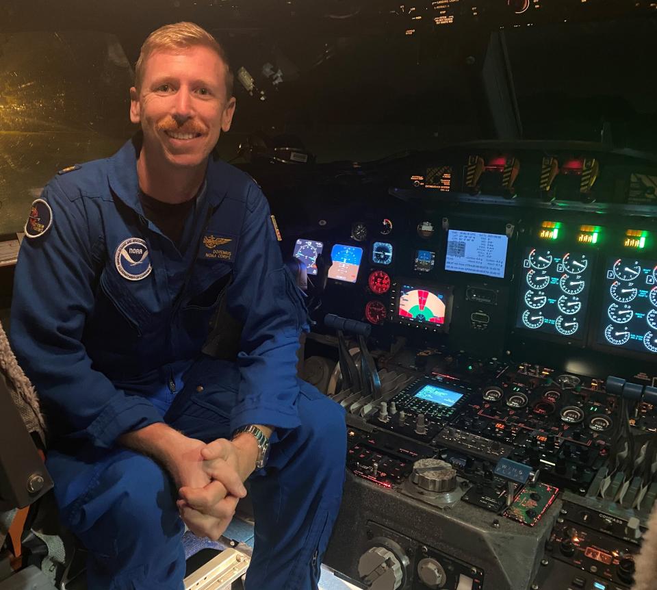
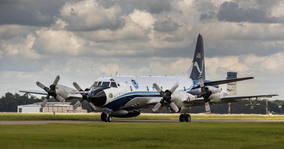
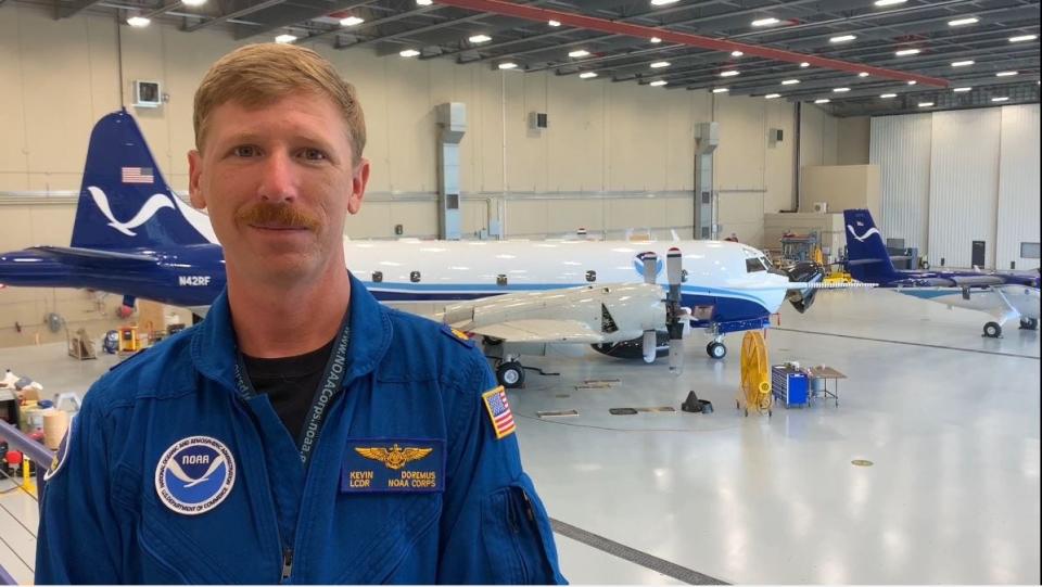
A Florida Institute of Technology graduate, Doremus is a Hurricane Hunter aircraft commander who flies Lockheed WP-3D Orion four-engine turboprop planes into the center of tropical cyclones during weather reconnaissance and research missions.
And he credits these instrument-packed airborne meteorological stations with helping the National Hurricane Center forecast Dorian's future movements.
“We were able to provide the hurricane center with the information that they needed to publish a really, really accurate track forecast. The hurricane center had it coming up to the Bahamas, parking, and making a right turn and just shooting up the coastline. And it did almost exactly that," Doremus said.
"The hurricane center absolutely nailed that. In part, that was because of the information that was coming from our aircraft," he said.
"And that was a really important decision for the hurricane center to make — because if they weren't confident, they would have had to evacuate the entire East Coast of the United States," he said.
Will Florida dodge a major hurricane strike again in 2022? Forecast shows increased risk
'Hurricanes don't care about your timeline': Experts urge preparation for storm season
'Cat 6' hurricane simulator with 200 mph winds, 20-foot storm surge under design
Miss Piggy and Kermit
Based at NOAA’s Aircraft Operations Center at Lakeland Linder International Airport, Doremus has racked up more than 3,000 hours of flight time in NOAA aircraft. The agency's Hurricane Hunters fly Miss Piggy and Kermit, the agency's Muppet-monikered WP-3D Orions.
NOAA flies offshore missions in tandem with the Air Force Reserve 53rd Weather Reconnaissance Squadron, which deploys meteorological data-gathering WC-130J Hercules aircraft based out of Keesler Air Force Base in Biloxi, Mississippi.
“What do you have in terms of observations over the water? You're limited to satellites, and the satellites will give you estimates of storm intensity. So without any reconnaissance, you really don't have a lot of data," said Steven Lazarus, Florida Tech professor of ocean engineering and marine sciences.
“The hurricane center relies on forecasts to get a better idea of where the hurricane’s heading. The recon is a source not only of in-the-moment data, but data that can be used to initialize a model that makes forecasts of where the hurricane is heading. And how intensive it may or may not get," Lazarus said.
"So that's a data source that otherwise doesn't exist," he said.
Doremus grew up in the Boston area, and he was introduced to Florida Tech at a career fair. He moved to Melbourne and initially studied engineering and biology, but his heart wasn’t into it. So he switched to the flight program: “I felt like I found my calling.”
“I always thought that you go be a commercial pilot, and you go fly people around all over the place in your big fancy bus," Doremus recalled.
"In my junior year of college, I learned about NOAA and found out that NOAA had aircraft, and I was able to secure an internship at the Aircraft Operations Center back when we were based at MacDill Air Force Base," he said.
"I was like, 'This is awesome. I'm going to take my love of science and my love of aviation and put them together — and I get to fly,' " he said.
Doremus earned a bachelor's degree in aviation management with flight in 2010, then earned a graduate certificate in coastal studies from Nova Southeastern University. He went through NOAA officer school in 2011 and launched his flying career.
Testing radar in what would be TS Alex
The Atlantic hurricane season kicked off June 1. What later became Tropical Storm Alex — the new season's first named storm — drew NOAA's attention when it was still a weak disturbance in the Gulf of Mexico. Kermit was stationed in Kansas City monitoring supercells to support tornado research, so Doremus flew Miss Piggy to investigate.
“At the time, it was Tropical Cyclone Number One. We were testing out one of our radars on board. We have a radar in the tail of the aircraft. It's a very unique radar. It's a vertical-scanning tail Doppler radar," Doremus said.
"It was kind of like a shakedown flight. But it was definitely one of those like, 'OK, it's hurricane season this year. It's time to kick it into high gear.' And we're ready for it when the time comes," he said.
Previously: Now-Tropical Storm Alex only brought 1-3 inches of rain, 48-mph wind gust to Space Coast
NOAA experts are predicting a seventh straight above-average hurricane season, which lasts until Nov. 30. The forecast calls for 14 to 21 named storms (winds of 39 mph or higher) and six to 10 hurricanes (winds of 74 mph or higher). That latter category may include three to six major hurricanes packing winds of 111 mph or higher, ranking as Category 3, 4 or 5.
Doremus said Hurricane Hunter missions typically fly from 8,000 to 10,000 feet above the water's surface. His planes deploy droposones — tubular instruments that function like "a weather balloon in reverse" — that fall through different layers of storms and relay data on wind speed, temperature, atmospheric pressure, humidity and dew point.
Kermit and Miss Piggy also carry "the Smurf," a stepped frequency microwave radiometer attached to the bottom of the left wing. This device can measure wind speeds and rain rates at the water’s surface.
Weather information is streamed from the planes in real time — in fact, Doremus said forecast models are typically updated before the crew returns to land.
“When you have these big thunderstorms moving across the United States, you learn a lot about them because we have all these resources on the ground. When you have these big hurricanes that are barreling across the Atlantic or coming up the Gulf, there are no weather reporting stations," Doremus said.
"You are counting on remote sensing capabilities, usually satellites, to give you a general picture of what's going on," he said.
"But (the WP-3D) is just a big flying weather-reporting station. And so, we go where the science needs us to go. We take that piece of equipment up right into the storm where the science wants us to be. And we provide that real-time information," he said.
Rick Neale is the South Brevard Watchdog Reporter at FLORIDA TODAY (for more of his stories, click here.) Contact Neale at 321-242-3638 or rneale@floridatoday.com. Twitter: @RickNeale1
Support local journalism. Subscribe today.
This article originally appeared on Florida Today: Hurricane Hunter Florida Tech flies NOAA planes to improve forecasts

