Hurricane Ian blog: Tropical storm warning in effect for Richmond, Columbia counties
Return to this story for blog updates throughout the week as more information becomes available.
Sept. 29
Richmond County schools closing Friday
Just four hours after it announced early dismissals, Richmond County School System upgraded its plan to a full county wide shutdown for Friday.
School district spokesperson Lynthia Ross said via email that this was in reaction to the National Weather Service upgrading Richmond County's status to a tropical storm warning.
The College Board has also rescheduled the Oct. 1 SAT tests to Oct. 15.
Fort Gordon prepares for Hurricane Ian
Fort Gordon released a statement Thursday afternoon saying the base has "taken proactive measures" this week to ensure its services can respond immediately to any inclement weather situations that arise.
The Department of Public Works on post has staged generators and everything needed to ensure the storm will not affect the base. Liaison officers are also put on notice, similar to an on-call doctor, and they are ordered to remain within two hours of Fort Gordon in case they are needed.
The Fort Gordon Emergency Operations Center is also activated and will respond to storm-related incidents like burst pipes, power line outages, or any other issues that need to be addressed.
Any additional updates and changes will be shared immediately through internal channels and shared on the Fort Gordon Garrison Facebook page: https://www.facebook.com/ftgordonga.
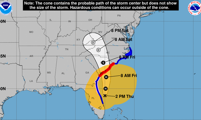
Tropical storm watch upgraded to warning
The tropical storm watch was upgraded to a tropical storm warning for Richmond, Columbia and Aiken counties.
Tropical Storm Ian is located about 330 miles south of Orangeburg, South Carolina and is expected to bring strong wind and flooding to the Augusta area.
Fort Gordon Golf Trifecta Tournament rescheduled
Fort Gordon MWR's Fall Trifecta Golf Tournament, originally set to take place over the weekend, has been rescheduled.
The new date of the event is Oct. 22 at 8:30 a.m., according to a release from Fort Gordon.
More: Commission recommending name change for Fort Gordon to Fort Eisenhower completes work
A Gordon Lakes staff member will reach out to confirm the new date with those signed up, according to the release.
McDuffie County schools closing Friday
All McDuffie County public school students will be staying home Friday.
McDuffie County School System announced they would be closed all day in a news release and that students will not have to make up the school day because the closure is due to weather.
School district spokesperson Kristopher Wells said, "The safety of our staff and students continues to be our top priority."
McDuffie County is the first local public school system to announce a county-wide closure as a result of Hurricane Ian.
City of Augusta handing out free sandbags Thursday
The City of Augusta is offering Richmond County residents free sandbags Thursday afternoon, ahead of Tropical Storm Ian's arrival.
The distribution site is located at 2316 Tobacco Rd. and residents can get up to five bags while supplies last, according to a release from the city. The site will be open 3-5 p.m. Thursday.
For more information, visit augustaga.gov.
Richmond County schools releasing early Friday, Augusta colleges monitoring weather
The Richmond County School System noted in a news release that all schools would be released early Friday out of concern for the weather.
The early dismissal schedule is as follows:
Schools that normally dismiss at 2:10 p.m. will get out at noon.
Schools that normally dismiss at 3:05 p.m. will get out at 12:45 p.m.
Schools that normally dismiss at 3:20 p.m. will get out at 12:55 p.m.
Schools that normally dismiss at 4:05 p.m. will get out at 1:30 p.m.
There will also be no onsite after-school programs on Friday.
"Although weather can change, making the decision today to operate our schools on an early release schedule tomorrow gives parents, students, staff and the community an opportunity to plan and put safety first," noted schools spokesperson Lynthia Ross on Thursday. "We continue to monitor the path of Tropical Storm Ian and will update families if weather projections for our community change."
Augusta University and Augusta Tech reported Wednesday that they are monitoring the forecasts, but have not made any changes yet to their normal class schedules.
The Augusta Chronicle reached out to representatives at the Columbia County School System, Aiken County Public Schools and Paine College on Wednesday asking for their weather plans. No response was issued as of Thursday morning.
Tropical storm watch remains active Thursday morning
A tropical storm watch is in effect for Richmond, Columbia and Aiken counties. Tropical Storm Ian, which made landfall in Florida on Wednesday, is about 380 miles south of Augusta.
The watch was issued at 5:25 a.m. Thursday.
More: Augustans prepare for Hurricane Ian, clear grocery store shelves
More: Comcast offers free WiFi hotspots in Augusta, Aiken as Hurricane Ian nears
The storm is expected to head toward coastal portions of southern South Carolina on Friday as a strong tropical storm or hurricane, according to the National Weather Service.
Significant impacts from Ian are expected to begin late Thursday night and into Friday morning across the midlands and CSRA. Heavy rainfall may lead to flash flooding Friday; tropical storm force winds are also expected.
Sept. 28
Tropical storm watch issued for Augusta, Fort Gordon
The National Weather Service in Columbia has issued a tropical storm watch for Augusta and Fort Gordon.
A tropical storm watch means tropical storm-force winds are possible somewhere within the area within the next 48 hours, according to the weather service.
Forecasted wind is below tropical storm force wind, although the peak wind forecast is 25-35 mph with gusts up to 45 mph. There is also potential for wind from 39 to 57 mph.
The weather service said to plan for hazardous wind of equivalent tropical storm force and efforts to protect property should now be underway.
More: Augusta-area high school football games rescheduled due to Hurricane Ian
Damage to porches, awnings, carports, sheds, and unanchored mobile homes is possible. Many large tree limbs may be broken off and a few trees snapped or uprooted, but with greater numbers in places where trees are shallow rooted, according to the weather service. Some fences and roadway signs may be blown over. Hazardous driving conditions on bridges and other elevated roadways is expected.
Peak rainfall will amount to 3 to 6 inches, with potentially higher amounts in some areas. Emergency plans should include the potential for moderate flooding from heavy rain. Evacuations and rescues are possible, according to the weather service.
More: Hurricane Ian updates: Savannah, Augusta have potential flooding risks over next three days
For more information, visit the National Weather Service website.
What Richmond, Columbia counties are doing to prepare for Hurricane Ian
Augusta Chronicle reporters surveyed all of the locations listed as flood hazard areas in the City of Augusta's Flood Mitigation Plan. According to the plan, flood hazard areas are found along all waterways, including the Savannah River and urban streams.
Augusta Chronicle reporters visited the Savannah River, Phinizy Swamp, Savannah Lock and Dam, Rae's Creek and Cranes Creek Wednesday afternoon, but did not see any sandbags placed.
Richmond County officials have yet to make a statement or release any plans in place for the storm. Richmond County workers told an Augusta Chronicle reporter Wednesday afternoon there were no plans to place any sandbags in preparation for flooding.
Richmond County has not responded to storm-related inquiries.
Columbia County officials released a statement Wednesday afternoon saying the county is prepared for the storm and will provide updates.
"Columbia County maintains a perpetual state of readiness for all emergencies, to include those which are weather related," said Shawn Granato, Columbia County EMA director. "Specifically regarding Hurricane Ian, the Columbia County Emergency Management Agency (CCEMA) placed the Emergency Operations Center in a warm status as we track current and potential worsening conditions. CCEMA regularly provides updates to all county departments while in constant communication with County Management and GEMA."
The county also provided preparation advice for residents.
"Columbia County citizens should prepare by assembling their emergency supplies and making sure that plans are in place for any persons on medical equipment dependent upon electricity and monitor weather reports from the local media," Granato said. "Columbia County EMA is providing all updates from the National Weather Service via social media."
Hurricane Ian makes landfall on Florida's southwest coast
Hurricane Ian made landfall on Florida's southwest coast as a major Category 4 storm.
The hurricane made landfall with maximum sustained winds near 150 miles per hour, according to the National Hurricane Center.
More than 1.1 million homes and businesses across Florida are without power, according to a USA Today article.
More: Hurricane Ian makes landfall on Florida's southwest coast as major Category 4 storm: Live updates
Fort Gordon cancels fall festival, Oliver Hardy Festival tentatively still on
Fort Gordon MWR announced midday Wednesday that they have canceled their annual Fall Festival and Flea Market.
The festivities were scheduled for this weekend, Sept. 29 through Oct. 2, and included a carnival, Oktoberfest entertainment, a variety of local vendors selling their merchandise and other activities.
Another big event scheduled for this weekend is the 33rd annual Oliver Hardy Festival in Harlem. Organizers said the festival is tentatively still on for Saturday, but the City of Harlem will be making a final decision on whether or not it will be canceled Friday morning.
Special weather statement issued for Richmond County
The National Weather Service in Columbia issued a special weather statement for the Richmond County Wednesday, warning of increased fire danger.
The weather service said high pressure will build into the Upper Midwest and Great Lakes region Wednesday through Thursday directing dry air into the Augusta region.
More: Severe weather guide for Augusta: Here's what you need to know
Surface pressure coming from the north and Hurricane Ian coming from the south will result in gradually increasing wind speeds from the northeast. Wind gusts are expected to peak around 20 mph and will continue to climb as Hurricane Ian moves closer.
This will lead to increased fire danger concerns, according to the weather service.
The alert is active until 5 p.m. Wednesday.
More: Red Cross of Augusta volunteers deploy to Florida, southern Georgia for Hurricane Ian
Wind speed and rain: What Augustans will see during the storm
Wednesday: Temperatures will drop Wednesday night, with a low of 58 degrees, and winds will pick up to 10 to 20 mph. Augustans will be able to see large branches and small trees begin to sway; waves will form in inland lakes and large rivers.
More: Hurricane Ian updates: Savannah, Augusta have potential flooding risks over next three days
Thursday morning: Winds will pick up to 15 to 25 mph. Winds could occasionally gust over 40 mph. Augustans will notice large branches will be in continuous motion; whistling sounds will be heard in overhead or nearby power and telephone lines.
Thursday night: Rain begins and winds remain at 15 to 25 mph.
Friday morning: Tropical storm conditions are possible. Winds will reach 20 to 30 mph and rainfall accumulation is expected to be over one inch. Augustans may notice whole trees in motion and have difficulty walking against the wind.
Friday night: Rain continues and wind speed will remain steady at 20 to 30 mph. Rainfall is predicted to be over one inch, but heavier rainfall is possible.
Hurricane Ian to make landfall Wednesday afternoon
Hurricane Ian strengthened into an "extremely dangerous" Category 4 storm and is on the brink of reaching a Category 5. Its maximum sustained winds are approaching 155 mph and AccuWeather forecasters predicted landfall just northwest of Fort Myers around 4 p.m. Wednesday.
At 8 a.m., the center of Ian was located 55 miles west of Naples.
More: Hurricane Ian nears historic Category 5 status as it nears Florida landfall: Live updates
Sept. 27
What to know about potential flooding in Augusta
While flooding in Augusta typically does not cause damage to buildings, drainage issues can cause water to accumulate on major roads.
Flood hazard areas are found along all waterways, including the Savannah River and urban streams, according to the Augusta Flood Mitigation Plan. The U.S. Army Corps of Engineers operates flood controls on the Savannah River, but there remains a low probability of significant flooding.
Downtown Augusta is protected by the Augusta Levee along the Savannah River from the boundary with Columbia County downstream to the New Savannah Lock and Dam.
Hurricane Ian updates: Storm may hit Georgia later this week; state making preparations
Looking back: Historical Photos: Augusta floods, 1912-1994
The urban streams where flooding has caused the most damage include Rae’s Creek, Cranes Creek, Rock Creek, Augusta Canal, Rocky Creek, and Oates Creek, according to the city.
East Augusta has some expansive flood-prone areas including the Phinizy Swamp and below the Savannah Lock and Dam, where the Savannah River floodplain is no longer modified by the Levee.
Georgia Power, Comcast preparing for Ian
Comcast has begun preparing for Hurricane Ian in Augusta to ensure any issues caused by the storm are resolved.
Preparations include staging emergency generators and fuel trucks, as well as bringing in additional technical and network restoration teams that are ready to be deployed as the storm’s path becomes clearer, according to a news release from Comcast.
Tips from Comcast to avoid losing service
Plug TVs, modems and cable boxes into a surge protector to protect them from damage in case of lightning or a sudden power outage.
Emergency management procedures dictate electricity must be restored first and Comcast must receive clearance that it is safe for crews to begin any restoration work.
Customers should always stay clear of downed power and cable lines in the interest of safety.
Keep cell phones dry and charged.
Make sure all emergency contact numbers and emails are saved on mobile phones.
Forward a home phone number to a mobile phone number so that customers can receive emergency calls even if they are not home.
During the storm, text instead of calling. Texts require fewer network resources.
Georgia Power is also prepping for the storm by securing resources and adjusting its plans, according to a news release.
Tips from Georgia Power
Before a storm: Stay aware and check the weather forecast before heading outdoors. Check your emergency kit, unplug major appliances and charge cell phones in case you lose power.
During a storm: Take safe shelter inside a sturdy building away from windows and doors. Avoid contact with conductors of electricity – appliances, metal objects and water.
After a storm: Never touch any downed or low-hanging wire, including telephone or TV wires that touch a power line. Never pull tree limbs off of power lines yourself or enter areas with debris or downed trees as downed power lines may be buried in wreckage.
For live updates on power outages, visit Georgia Power's Outage Map: https://outagemap.georgiapower.com/.
This article originally appeared on Augusta Chronicle: Hurricane Ian: Live updates, weather in Augusta

