When Hurricane Ian came roaring in: How each county handled life-saving evacuations
Sunday, Sep. 25
11 p.m. — NHC gives first storm surge depth prediction: 4 to 7 feet for most of Lee County. Storm surge watch issued for areas including Cape Coral, Fort Myers Beach and Fort Myers.
FOR SUBSCRIBERS: These 3 factors created a 'worst-case scenario' with Hurricane Ian that proved deadly
'Cone of uncertainty': confounds people who focus on skinny black line
Hurricane Ian: Forecasters still struggle to warn people of hurricane storm surge dangers
Eyewall change: Hurricane Ian underwent an eyewall change, turning a disheveled mess into a monster

Florida Division of Emergency Management Director Kevin Guthrie says people should check their evacuation zones and stay put if they aren’t in one unless they don’t trust their homes to survive the storm.
🌀 With potential impacts from #Ian next week, Floridians should take the time to learn if they live in an evacuation zone or flood-prone area.
This can help with:
🗺 Mapping evacuation routes
🚨 Understanding orders from local officials
Learn more - https://t.co/5C0Wq9aHaj pic.twitter.com/PVxFs4JZCx— FL Division of Emergency Management (@FLSERT) September 24, 2022
Monday, Sept. 26
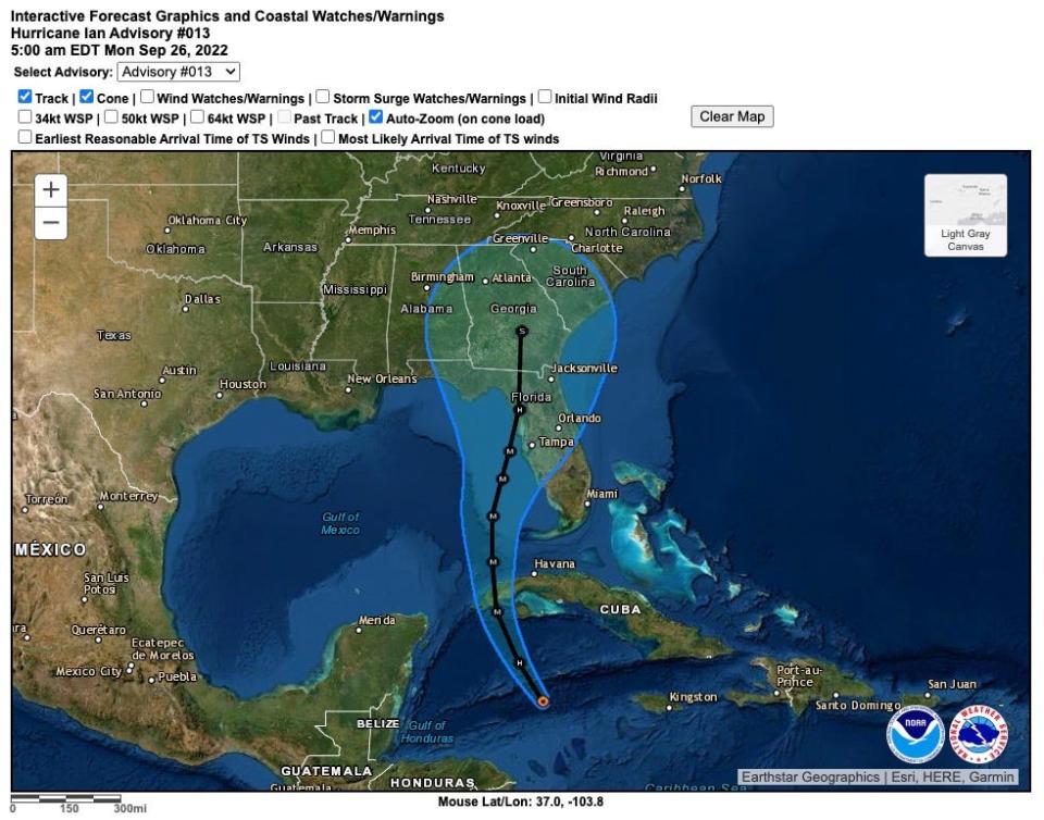
5 a.m. — Ian becomes a hurricane with rapid intensification forecast.
5 a.m. — Hurricane watch issued for west coast of Florida from Englewood to Anclotte River, including Tampa Bay.
Near noon — Manatee issued evacuation orders but effective beginning 8 a.m. Tuesday.
10:30 a.m. — Lee County declares state of local emergency.
3:30 p.m. — Charlotte County orders evacuations for Zone A.
Charlotte County Emergency Management has issued evacuation orders for residents in Zone A - Red areas. This includes those living on the barrier islands as well as residents in any zone living in mobile homes and trailers. pic.twitter.com/Ay09pySdTt
— Charlotte County Emergency Management (@CCOEM) September 26, 2022
5 p.m. — Sarasota and Manatee counties issue hurricane warnings. Lee County government offices shut down.
5 p.m. — Hurricane watch issued for Bonita Beach to Englewood, including Charlotte County.
7 p.m. — Sarasota calls for Zone A evacuations.
Sanibel City Council unanimously approves a local emergency and issues voluntary evacuations.
Tuesday, Sept. 27
5 a.m. — Hurricane warning extended from Sarasota County south to Bonita Beach, which is in Lee County just north of the Collier County line. This warning includes Charlotte County.
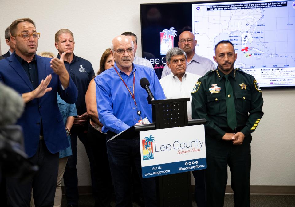
7 a.m. — Lee County orders mandatory evacuations for coastal areas.
Lee County Manager Roger Desjarlais said that barrier islands could be overwashed and people who decide to stay on them “do so at their own peril.” Desjarlais said the county had considered beginning evacuations Monday but that the storm’s path was still uncertain.
8 a.m. — NHC storm surge depth prediction is now 5 to 10 feet through Bonita Beach.
8 a.m. — Manatee’s evacuation order in effect.
9 a.m. — Cape Coral declares local state of emergency, urges residents to evacuate.
10:30 a.m. — Charlotte County orders evacuations to include Zone A and B.
10:45 a.m. — Collier County calls for voluntary evacuations of immediate coastal areas. They make them mandatory later in the afternoon.
The previously issued voluntary evacuation for Zone A in #CollierCounty is now a MANDATORY evacuation. The Zone A map is pictured below.
To view your zone, visit https://t.co/zTaFNTouSn#HurricaneIan #EvacuationZone pic.twitter.com/hOWYQwuCXQ— Collier County Government (@CollierGov) September 27, 2022
11 a.m. — NHC storm surge depth prediction is increased to 8 to 12 feet
11 a.m. — Interim National Hurricane Center Director Jamie Rhome pleas for people in Southwest Florida to prepare.
“The thing that is most pressing to me, is we are really starting to lose time for people in the path of this system to take action,” Rhome said. “If evacuations are ordered, you need to heed them. There is not a lot of time to second guess. You need to move out quickly.”
1:45 p.m. — Lee County orders mandatory evacuations for portions of inland areas.
3:15 p.m. — Sarasota County extends evacuations to Zone B.
4:50 p.m. — Collier orders mandatory evacuation of Zone A.
5 p.m. — Hurricane warning issued for Collier County, just south of Lee County. It begins mandatory evacuations for Zone A.
The previously issued voluntary evacuation for Zone A in #CollierCounty is now a MANDATORY evacuation. The Zone A map is pictured below.
To view your zone, visit https://t.co/zTaFNTouSn#HurricaneIan #EvacuationZone pic.twitter.com/hOWYQwuCXQ— Collier County Government (@CollierGov) September 27, 2022
Around 11 p.m. — Ian undergoes what meteorologists call an eyewall replacement cycle, a phenomenon that occurs when extreme pressure pushing on the eye of the storm causes it to collapse and a new, usually larger, eye forms. It extends the range of most damaging winds and adds to the overall size, meaning more winds to push more storm surge on shore.
I'm not sure how many truly grasp what just happened tonight with Hurricane #Ian. It went through a full eyewall replacement cycle, hardly blinked, grew by 50% (as measured by its RMW), and delivered the 3rd highest storm surge since 1913 to Key West in the process. Just wow. pic.twitter.com/UmbuA8gJ7v
— Michael Lowry (@MichaelRLowry) September 28, 2022
Wednesday, Sept. 28
5 a.m. — Sanibel Islands has sustained tropical-storm-force winds (minimum of 39 mph) with 55 mph gusts.
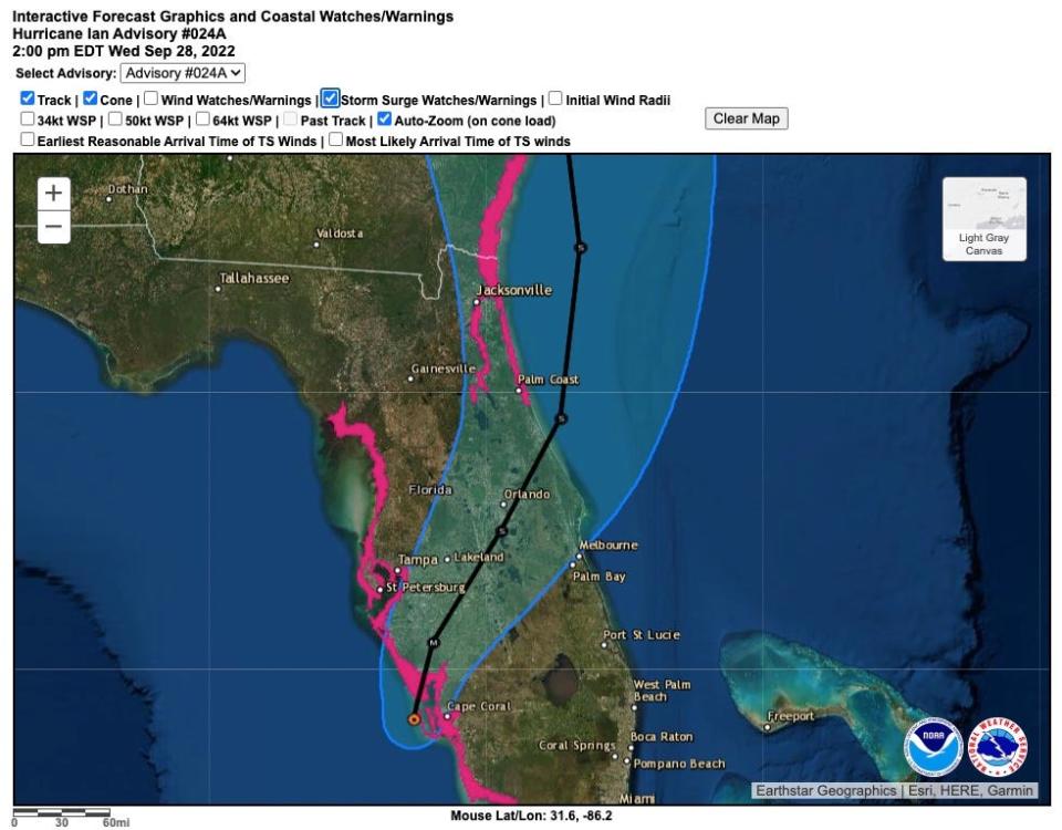
8 a.m. — NHC storm surge depth prediction increases to 12 to 16 feet.
9 a.m. — Special alert from NHC that storm surge prediction for most of Lee County has increased to 12 to 18 feet.
If #Ian storm surge didn’t have its own @NWS watch & warning, which would’ve been true 6 years ago, then maybe one could say it came without warning. Not now. Since 2017 storm surge has its own watch & warning. Call to action is to follow local officials’ evacuation instructions. pic.twitter.com/0tFd9fyVHN
— Dr. Rick Knabb (@DrRickKnabb) October 5, 2022
10:45 a.m. — Lee County tells residents it is no longer safe to travel on roads.
Noon — Sanibel winds are sustained at 71 mph with gusts of 98 mph.
The NHC reports Hurricane #Ian made landfall near Cayo Costa Florida around 305pm EDT (1905 UTC) with maximum sustained winds estimated near 150 mph (240 km/h). This is the corresponding #GOESEast view of the historic event. #landfall #HurricaneIan #FLwx pic.twitter.com/w7DErmOUnf
— UW-Madison CIMSS (@UWCIMSS) September 28, 2022
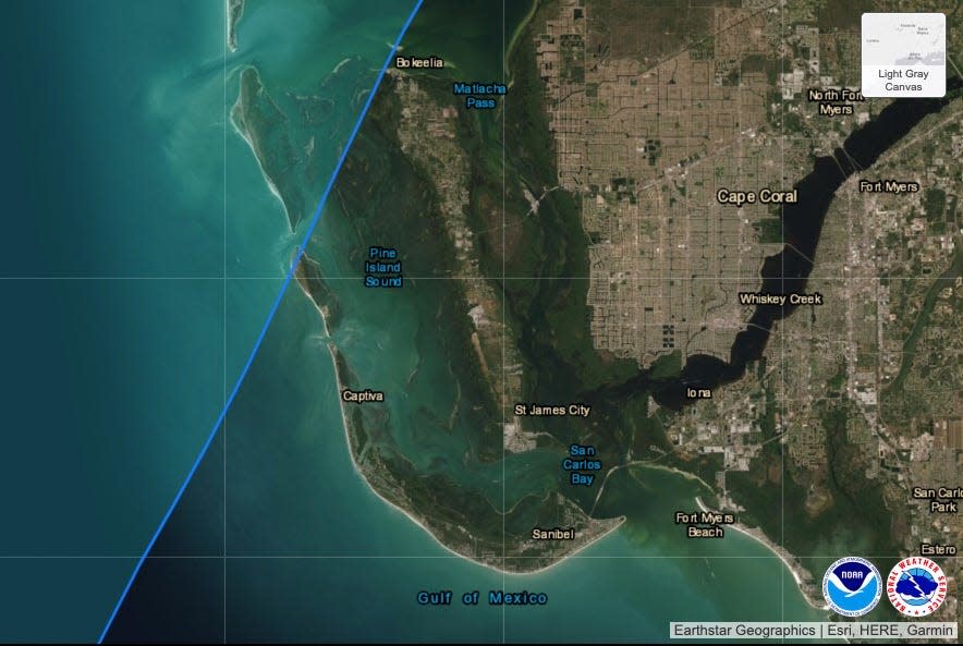
3:05 p.m. — Hurricane Ian makes landfall on the tiny Lee County island of Cayo Costa.
5:20 p.m. — Cape Coral feels wind gusts to 140 mph.
This article originally appeared on Fort Myers News-Press: Hurricane Ian: A look at how each county dealt with the oncoming storm.

