Hurricane Ian: Forecasters say Volusia, Flagler can expect 'major rainfall flooding'
Amid the mad rush for storm supplies ahead of Hurricane Ian’s anticipated midweek landfall along Florida’s Gulf Coast, Don Shamp checked two crucial items off his list on Monday morning.
“Now I’m pretty well set,” said Shamp, 69, of DeBary, as he hoisted two 24-packs of bottled water and one case each of Busch and Michelob beer into his Ford van outside the Winn-Dixie supermarket at the corner of U.S. Highway 17-92 and Highbanks Road in DeBary.
“It’s the first time I’ve been out to get supplies,” said Shamp, a retired construction worker who has lived in the area for 25 years. “I figured I’d wait until everybody else went back to work, but I guess my timing was perfect. I think the water delivery had just come in.”
Get the latest: Hurricane Ian continues to strengthen. Hurricane watch issued for portions of Florida
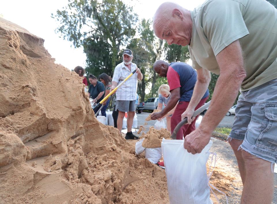
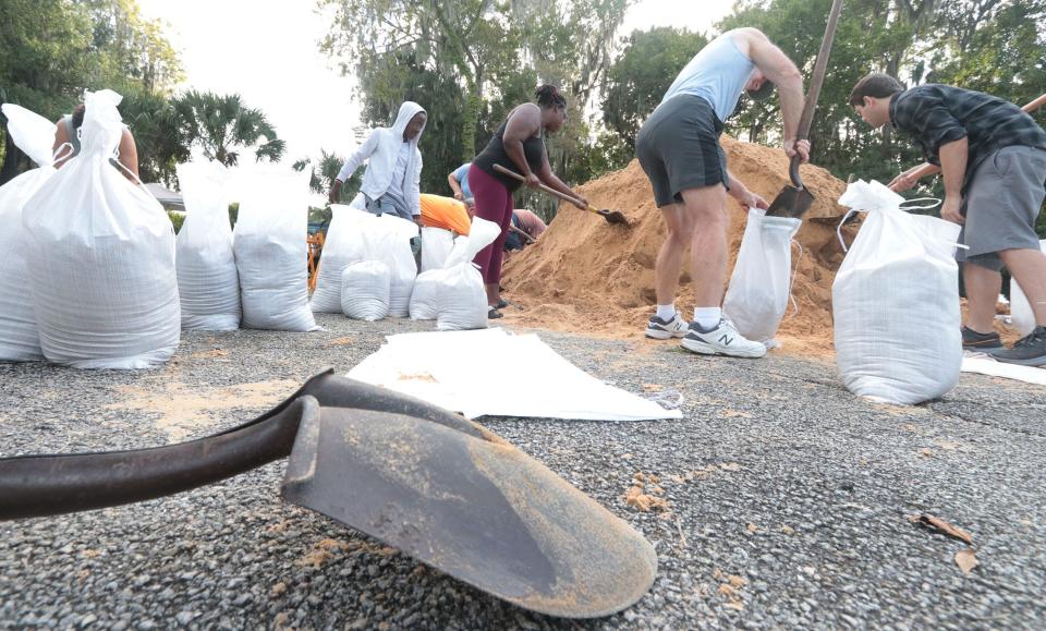
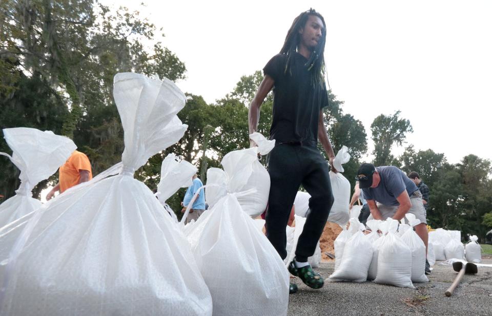
Where to find sandbags: Free sand, bags offered throughout Volusia County as residents prepare
Be prepared: Your guide to the 2022 hurricane season in Florida
Throughout Volusia and Flagler counties, residents were still on the prowl for items that were increasingly hard to find, including bottled water, batteries, gasoline and generators.
As they prepared, forecasters at the National Hurricane Center and the National Weather Service in Melbourne continued to track Ian as the storm was expected to strengthen Monday morning from its sustained winds clocked at 80 mph.
In the Hurricane Center's 5 p.m. update on Monday, a tropical storm watch was issued for Florida's east coast from Jupiter Inlet north to Altamaha Sound in Southern Georgia, an area that includes Volusia and Flagler counties. The watch also included areas from the Suwannee River to Indian Pass on Florida's west coast.
In the same update, a storm surge watch was issued from Altamaha Sound south through Flagler County to the Volusia County line, a watch that also included the St. Johns River.
Ian was expected to strengthen rapidly on Monday, unleashing significant wind and storm surge to Cuba before entering the Gulf of Mexico and heading toward Florida. At 5 p.m. Monday, a hurricane watch was issued for the west coast of Florida from north of Englewood to the Anclote River, including Tampa Bay.
Winds are forecast to reach 140 mph within 36 hours, with hurricane-force winds now extending 35 miles from center, and tropical-storm-force winds extending 115 miles, but it's the rainfall that could become the biggest danger.
Hurricane Ian expected to make rainfall hazards soar
As it appeared Hurricane Ian could slow to a crawl in the Gulf of Mexico, the rainfall hazards soared for the East Central Florida coast. Rain estimates now range from 8 to 15 inches in Volusia and Flagler counties, based on forecast information from National Weather Service offices in Melbourne and Jacksonville.
That rain could exponentially increase water levels in ponds, streams and rivers that are already near or at flood stage in the area, weather service forecasters across Florida said Monday. The St. Johns River at Astor in West Volusia County is at flood stage, and so is Haw Creek Landing in western Flagler County.
"Prepare for life-threatening rainfall flooding to have possible extensive impacts across east Central Florida," warned the Melbourne weather service office. "Major rainfall flooding may prompt many evacuations and rescues."
Rivers and tributaries could flood structures in multiple communities, and possibly cover escape routes, the office stated.
Officials throughout Florida warned residents in low-lying areas who are asked to evacuate to heed those warnings and not put their lives in danger.
“Flooding rain is the greatest threat for the area, followed by the potentials for high winds, tropical storm force winds,” said Jessie Smith, meteorologist with the National Weather Service in Melbourne. “At this point, there’s a lot of uncertainty with this storm, a lot of information can change as the forecast changes.
“Right now, for Volusia County, we are anticipating a 60% chance of tropical storm force winds, and about 10% chance of hurricane force winds,” Smith said. “As far as the timing of that, it looks like the earliest time we can reasonably see those winds arrive is by 8 a.m. Wednesday morning. Anyone who is doing preparation or planning to make an evacuation, that needs to be completed by Wednesday.”
On Monday, that preparation involved dozens of sweat-soaked residents shoveling sand into bags at distribution locations in Orange City, DeLand and elsewhere. Generally, the mood was more about preparation than panic.
“I just want to keep my yard from washing away,” said James Jones, 64, as he tossed sandbags into the bed of his pickup truck at Waggin’ Trail Dog Park in Orange City. “I’ve been through every one of the storms since 1964, and I haven’t done anything too special. I do just enough to keep myself afloat.”
In DeLand, more residents were loading sandbags at a distribution location outside Melching Field.
“I lived in Miami and I went through (Hurricane) Andrew,” said George Tobar, 54, a retired law enforcement officer. “All you can do is monitor everything, get your food supplies, your water supplies, then just hunker down and be ready. There’s only so much you can do to be prepared.”
Volusia County officials expect 'significant rain event'
As residents prepare, emergency management officials in Volusia County are monitoring Hurricane Ian as it moves toward the area.
On Monday, county officials also expected “a significant rain event," according to a news release.
County officials remain in regular contact with the National Weather Service and Florida Division of Emergency Management officials and continue to organize sandbag distribution events, said Kevin Captain, director of community information for Volusia County.
"All the county divisions right now are in the readiness mode and preparations mode to be mobilized in the event that they're needed," Captain said.
The county hadn't decided by Monday afternoon whether to open shelters.
"If or when we do open those shelters, we'll be making those public announcements," Captain said.
Jim Judge, interim director of emergency management, said sheltering outside an evacuation area in a hotel or safe place with family and friends is the best idea for people who need to evacuate.
Captain and other county officials encouraged people to get ready with disaster supply kits and evacuation plans.
Volusia County's potential shelters include 14 local schools and the Volusia County Fairgrounds, and combined they can shelter up to 5,000 people, according to a news release. The county can open more spaces if needed.
People who would require a special needs shelter should register now, officials said.
The Special Needs Shelter Program is intended to provide evacuation assistance and care for those without other alternatives, who need transportation assistance or have a health or medical condition that requires medical attention in the shelter, according to the county.
Special Needs shelter registration is available by calling 386-258-4088. The registration form is at volusia.org/core/fileparse.php/4360/urlt/PSNreg.pdf.
Votran and Volusia County Schools provide free transportation to public shelters. All Votran bus stops are evacuation assembly points during an evacuation order. People with special needs who can't get to a bus stop should call Votran at 386-322-5100 to arrange transportation.
The county also has opened its Citizens Information Center phone line at 866-345-0345. Callers can get information on the storm, sandbag distribution, disaster preparation and community resources such as shelters. Residents can call the center from 8 a.m. to 5 p.m. today and Tuesday. Officials say the center will be open more days as needed.
Anyone seeking county hurricane preparation updates and information about community resources, should go to volusia.org/pin. Information about sandbags is available at volusia.org/sandbags.

Volusia/Flagler schools open for now
For school students and parents, neither Volusia nor Flagler school districts have announced school closures so far, but Volusia County Schools has cancelled extracurricular activities for some of the week and one Daytona Beach university has already evacuated.
In an announcement shared over the weekend, Bethune-Cookman University issued a mandatory campus evacuation “as a precaution, and in the interest of safety for members of our campus community.”
Classes are not being held on Monday and will resume remotely on Tuesday using the school’s Canvas Learning Management System, the university announced.
Volusia County Schools on Monday had no plans to cancel school or extracurricular activities for Monday and Tuesday, according to an update on its website, but the district did cancel all after-school activities starting Wednesday through the end of the week.
Parents and students can receive updates by texting “Yes” to 68453, and updates are also available on social media and at the VCS Storm Resource Center webpage.
Flagler County schools have not announced any cancellations and is continuing to monitor Hurricane Ian along with the county’s emergency management team. The district will share schedule changes via press releases, phone calls to families, messages on district and school websites and social media channels.
Daytona State College on Monday had not canceled in-person classes but is actively monitoring the storm and communicating with county and state management teams, according to the school’s website.
Daytona Beach, other cities prepare
In Daytona Beach, residents with questions about Hurricane Ian can call the city’s Citizen Hotline, which opened from noon to 6 p.m. Monday at 386-671-5555. Starting Tuesday, the Citizen Hotline will be available from 8 a.m. to 6 p.m. until further notice.
In addition to sandbag sites in DeLand and Orange City, Deltona reopened its sandbag filling station in Festival Park, 191 Howland Blvd., from 9 a.m. to 5 p.m. Monday.
DeBary also reopened its sandbag site at City Hall, 16 Colomba Road, on Monday from 9 a.m. to 5 p.m., according to social media posts. Residents are limited to 10 bags per household and must bring proof of residency and their own shovel. The site is scheduled to be open on Tuesday from 9 a.m. to 5 p.m.
Temporary additional pumps have been set up in DeBary to draw down area lakes to create more storage capacity for the anticipated rainfall, according to the city.
Shoppers making storm preparations
Judging from crowded parking lots and aisles at area grocery and hardware stores, residents were working hard to finish final storm preparations.
At the Lowe’s on U.S. Highway 92 in DeLand, customers were ready to buy everything from generators to flashlight batteries.
“I’ve moved everything up against the house already,” said Richard Hewitt, a resident of a senior-citizen mobile home park in DeLand. “Now, I’m just getting some extra batteries that I need. I'm hoping that we get just a lot of rain and wind. Hopefully, we can survive that.”
In Port Orange, some shoppers are more concerned about the storm than others.
For local retired teacher Iona Hughes, the need to prepare, even if the storm’s path is still uncertain, cannot be neglected.
“I’m familiar with the drill,” Hughes said as she walked out of a Publix store on Dunlawton Avenue.
Hughes said she found everything she wanted and that there was still water on the shelves.
“Hurricane Matthew (in 2016) did me a lot of damage,” said Hughes, who has lived in the area since 1968. “About $75,000 worth of damages actually.”
She added her finances are “almost taken care of now” after the costs brought from the 2016’s storm. She has already brought furniture and plants in her backyard inside the house.
After being through many storms, Hughes said she isn’t afraid of them anymore, but she pays “attention to what is going on” and, if need be, she would have help from family members living in Tallahassee.
Other shoppers at the Publix found no reason to worry yet. Allison Bronky said she did not come to the store to prepare for the storm.
“I don’t get scared, because I think there is a lot of hype built around the storms,” Bronky said. “A lot of predictions are happening, and we still don’t know.”
She said that she will continue to monitor the storm’s path because “things could change in the next 48 hours.”
In Flagler, a 'high likelihood of flooding'
Flagler County residents also can get sandbags to prepare for Hurricane Ian, which is expected to bring “a high likelihood of flooding in some areas,” according to the county.
Sand and bags are available on Monday and Tuesday along with volunteers and inmate work crews from the Flagler County Sheriff’s Office to help fill the sandbags at the following locations:
• Flagler Technical College: 5633 N. Oceanshore Blvd., The Hammock; from 9 a.m. to 5 p.m.
• Fire Station 71: 89 County Road 2006 West, Bunnell; 9 a.m. to 5 p.m.
Palm Coast has sand and sandbags available for residents at three locations on Monday and Tuesday from 9 a.m. to 6 p.m. or until sand runs out.
There is a limit of 10 bags per vehicle. The stations will be staffed for those who need help at the following locations:
• Palm Coast Public Works Yard: 1 Wellfield Grade, off U.S. 1 just north of Palm Coast Parkway, Palm Coast;
• Daytona State College: 3000 Palm Coast Parkway SE, Palm Coast;
• Indian Trails Sports Complex, 5455 Belle Terre Pkwy, Palm Coast.
Sandbags will also be available for Flagler Beach and Beverly Beach residents only at Santa Maria Del Mar Catholic Church, 915 N. Central Ave., Flagler Beach, from 2 to 6 p.m. on Monday and from 10 a.m. to 6 p.m. on Tuesday.
Flagler Beach Police Chief Matt Doughney said in a phone interview that it appears from the reports that the storm is going to bring 7 to 15 inches of rain.
At this point, it’s not anticipated that the State Road 100 Bridge will be closed or that there will be any mandatory evacuation, he said. The city plans to close the pier on Wednesday, Thursday and Friday.
For information, visit www.flaglercounty.gov/emergency.
St. Johns County also prepares for potential flooding
Heavy rains expected from Ian combined with already wet grounds could mean flooding in St. Johns County, too, especially along the St. Johns River, said Kelly Wilson, deputy director of emergency management for St. Johns County.
St. Johns County was also looking into the possibility of opening shelters, she said.
Officials are urging residents to check their evacuation zones and have a disaster plan in place.
Residents can go to sjcemergencymanagement.com to check their evacuation zone and get information about hurricane preparedness. Disaster planning information can also be found at FloridaDisaster.org/Family-Plan.
County residents will be able to get free sandbags, up to 20 per person, at six locations from 9 a.m. to 5 p.m. on Tuesday and Wednesday if weather allows.
While the sand and bags are free, residents must provide their own transportation and shovels, and they have to fill their own bags, according to a county news release.
People who need information can call the St. Johns County Emergency Management Citizen Information Line at 904-824-5550.
Sandbag locations:
Windswept Acres Park, 5335 State Road A1A South
Solomon Calhoun Center, 1300 Duval St.
Hastings Town Hall, 6195 S. Main St.
Mills Field, 1805 Racetrack Road
North Beach Park, 3721 Coastal Highway
Palm Valley underneath the Palm Valley Bridge on the east side of the Intracoastal Waterway
News-Journal reporters Sheldon Gardner, Brenno Carillo, Eileen Zaffiro-Kean, Katie Kustura, Danielle Johnson, Frank Fernandez and USA Today reporter Dinah Voyles Pulver contributed to this story.
This article originally appeared on The Daytona Beach News-Journal: Hurricane Ian preparations continue in Daytona Beach area, Florida

