Hurricane Ian hit Cat 5 in Gulf, was Florida’s most expensive storm. Official final numbers
Hurricane Ian is officially the most expensive storm in Florida’s history, with a price tag of $109 billion in damage.
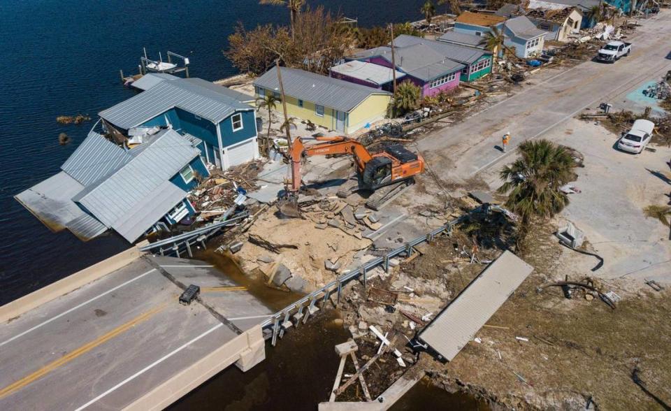
That’s the staggering loss from tens of thousands of homes and buildings in Southwest Florida damaged by Ian’s fierce winds and storm surge — and more than a thousand totally wiped away. Roads and bridges, including the Sanibel causeway, crumbled into the sea. As far away as Broward County across the state, a tornado spawned at the storm’s edge tipped over planes at a small airport, causing a couple million in damages.
A new National Hurricane Center report with the official numbers from Ian put the final death toll at 156 dead and found that at one point the storm did reach Category 5 strength before roaring ashore slightly weaker. The report, released Monday, is a comprehensive look at the hard numbers around Ian, including wind speed, storm surge height and rain totals.
It also discusses the hurricane center’s forecast for the storm, which critics say didn’t give Southwest Florida enough time to prepare and evacuate ahead of the storm. The NHC analysis acknowledged Ian was “challenging” and found that tracking forecasts tend to be biased to the left, away from the coast, but also that cone of uncertainty included Southwest Florida in the days before landfall.
Some key top findings:
Category 4? Or 5?
Hurricane Ian first made landfall in Cuba’s Pinar del Rio Province as a Category 3 hurricane, destroying 60% of the housing in the area. It stayed a Category 3 as its eye passed over the Dry Tortugas in the Florida Keys before continuing to strengthen in the warm waters of the Gulf of Mexico.
Originally, the NHC believed Ian only strengthened to a Category 4 before it hit Florida but researchers now say it actually reached Category 5 in the Gulf with sustained winds topping 160 miles per hour.
Hurricane Ian blasted Pine Island like never before. The community is sticking together
It weakened slightly before landfall in the barrier island of Cayo Costa, the report said, and likely hit Florida as a strong Category 4.
Researchers estimate it stayed a Category 4 for its second landfall on the mainland in Punta Gorda shortly later. But they can’t know for sure, since key equipment couldn’t stand up to Ian’s power.
“Because of instrument failure, no reliable surface observations exist from the coastal areas where the eyewall came on shore,” the report read.
By the time Ian reached Florida’s west coast, it was down to a tropical storm with maximum sustained winds around 70 miles per hour.
The financial toll
In total, NOAA’s National Centers for Environmental Information estimates that Ian did $112.9 billion of damage in the United States, making it the third-costliest storm on record.
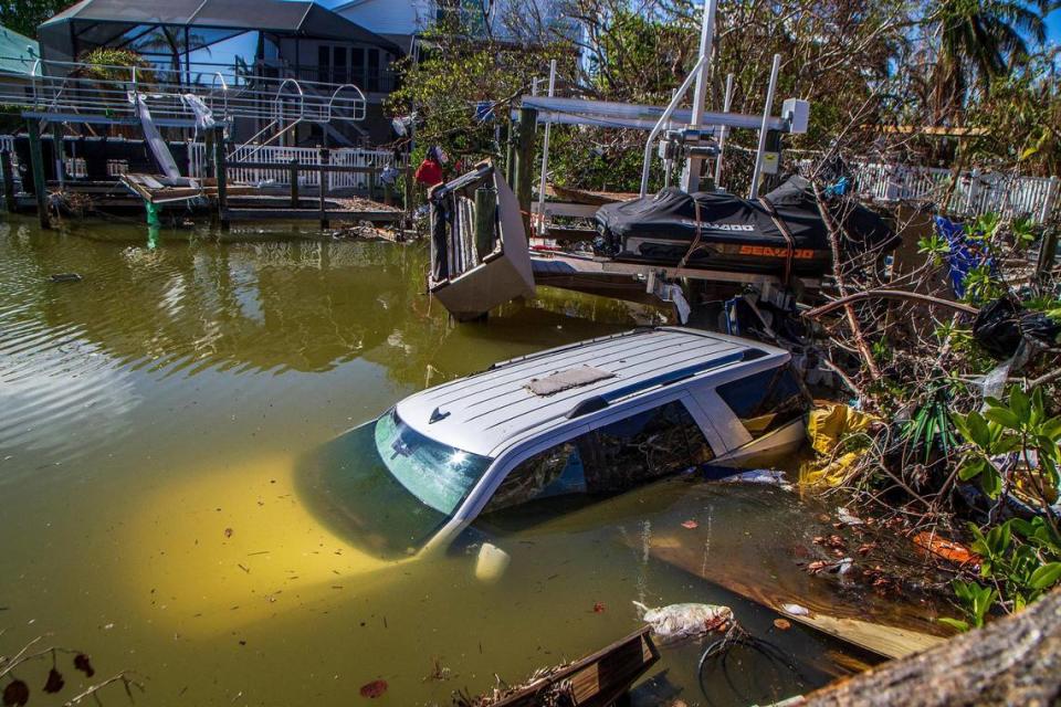
Most of that damage — $109 billion of it — happened in Florida. That makes it the state’s most expensive storm in history. That number reflects the tremendous number of buildings devastated in Ian’s high winds and relentless storm surge.
“In Fort Myers Beach alone, an estimated 900 structures were totally destroyed, and 2,200 were damaged. In Lee County, at least 52,514 structures were impacted, of which 5,369 were destroyed and 14,245 received major damage,” the report said.
That price tag will likely continue to tick up as more insurance claims and lawsuits roll in.
Lives lost
Although it was thought to be far higher at one point, the official final death toll from Hurricane Ian is now 156, with 66 of those deaths directly from the storm. Of those, most were from storm surge, with 41 deaths. The vast majority of those (36) occurred in Lee County.
This does not include people still missing since the storm, including 11 from a migrant boat headed from Cuba to the U.S. and a live-aboard couple from the Keys.
Their father, 87, evacuated for Hurricane Ian. Rattled by storm surge, he died in his car
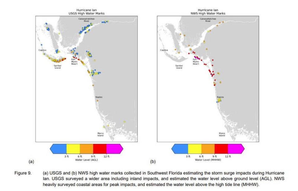
Record storm surge
At its highest point, researchers estimated Hurricane Ian sent 15 feet of water above ground crashing into Southwest Florida. But the measurements came in slightly below that figure.
The single highest recorded point was 12.7 feet over water at Fort Myers Beach Pier, which was nearly wiped out by the storm.
Fort Myers Beach and Estero Island caught the brunt of it, as even early damage estimates revealed, with 10 to 15 feet of storm surge above ground.
How high was Hurricane Ian’s storm surge? These scientists hunt down the answer
The eastern portions of Sanibel were pummeled with nine to 13 feet of water, and Pine Island, Cape Coral and communities along the Calahoosahatchee River saw six to nine feet.
The Keys saw only one to three feet of surge, still enough to flood multiple homes and make some roads impassable. Northeast Florida, where Ian exited, saw three to five feet of surge.
Record rain
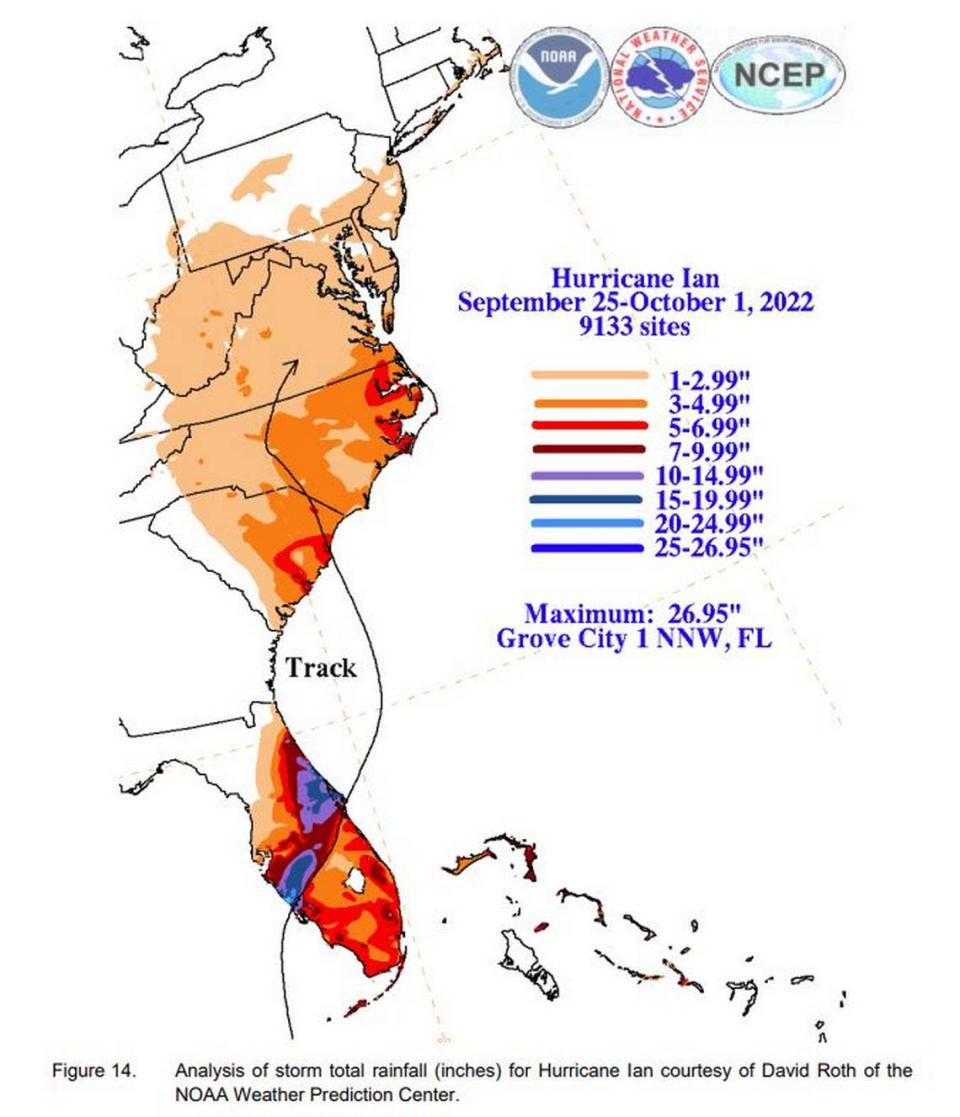
Although Ian may be best known for the havoc it wreaked on the southwest coast, inland Central Florida saw more rain than some places have ever experienced, leading to more than 250 water rescues.
The highest rainfall total was in Grove City in Charlotte County at 27 inches, but inland Florida saw 10 to 20 inches of rain.
Historic storm surge. Record flooding. Ian’s lesson in the rising risk of hurricanes
A questioned forecast
This report noted that the hurricane center’s official forecast exhibited a left-of-track bias for most of its forecasting for Ian, and was outperformed by some of the major storm models in the short term, including ones run by the United Kingdom and other outside forecasting groups.
On average, the report said, the NHC performed better than average for the soonest part of the forecast, the 12 and 24-hour mark, as well as the 120-hour mark. Forecasters did about average for the 36-hour and 48-hour mark and did worse than average for the 72 and 96-hour mark.
Ever since the storm, critics have pushed back on the NHC for its initial forecast, which showed a likely landfall in Tampa Bay. That led to a mass evacuation of the Tampa Bay area and less attention to more southern coastal spots.
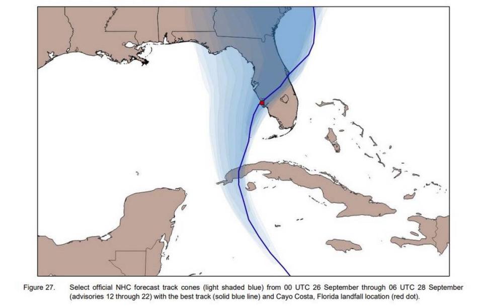
Just a few days before landfall, the forecast bent right, putting more of southwest Florida in the cone of uncertainty and taking the pressure off Tampa Bay. With less time to evacuate, many in the hardest-hit parts of the state chose to stay.
The hurricane center’s report did not get into the controversy, but it did stress that “the forecast track cone of uncertainty did contain the landfall location for all advisory cycles.”
Folks misunderstand hurricane ‘cone of uncertainty,’ study shows. Time for a change?
“In general, storms that parallel a coastline tend to be more challenging to predict because a small change in heading can cause large differences in the landfall location. Ian was an example of this particular challenge,” the report said.

