Hurricane Ian to hit Florida Wednesday. What does it mean for the Valley?
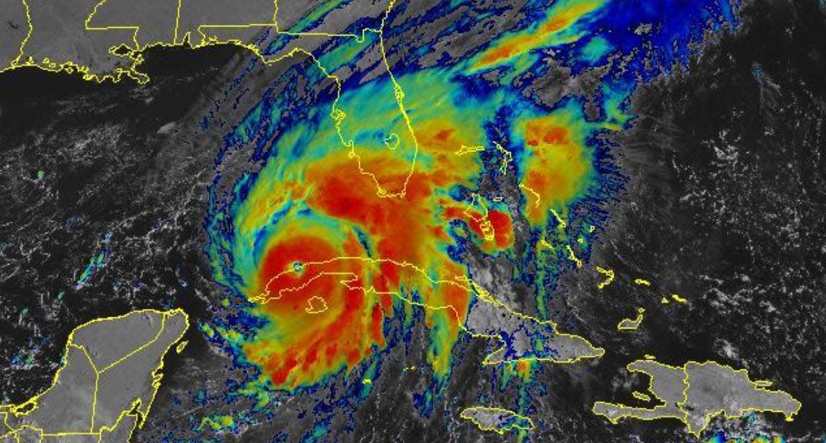
Hurricane Ian, a Category 3 storm, hit Cuba Tuesday morning with 125 mph winds and torrential rains. Its next stop is Florida in the Tampa Bay area.
According to USA TODAY, the storm was forecast to roll off Cuba and strengthen to a Category 4 storm over warm, Gulf of Mexico waters. The storm's winds could reach 140 mph before reaching Florida as soon as Wednesday, the article said.
As for the Southeast, heavy rainfall is expected to hit Friday and Saturday, according to USA TODAY. That could mean widespread flash and urban flooding mid-to-late week across central and northern Florida, southern Georgia and coastal South Carolina. Significant and prolonged river flooding is expected across central to northern Florida, USA TODAY said.
Flash flooding is expected over portions of the Southeast into the Mid-Atlantic mid-to-late week.
There is potential that the path could hit the Shenandoah Valley, but according to National Weather Service Meteorologist Connor Belak, our forecast area is outside the five day outlook for the National Hurricane Center. Belak said that by this time tomorrow, there could be more information regarding the path and impact the storm will have to the area. He said it's a "sensitive timeline."
According to the NWS, winds from the storm are expected to hit North Carolina by 8 a.m. Friday.
In past storms, the Valley has been hit hard by hurricanes that have turned into tropical storms. Last year, Hurricane Ida ran up the coast dumping rain on the Valley. The Commonwealth issued a state of emergency for the storm, at that time. In 2018, Hurricane Florence hit the Valley and flooded large sections of Augusta County and Waynesboro.
More:Waynesboro City Council will have four candidates for two open seats. Here's who they are.
More:New boutique in Staunton; Trolley tours — The buzz
More:Weyers Cave Volunteer Fire Company reports thousands of dollars in damaged property
National Weather Service forecast
Tuesday
Sunny, with a high near 69. West wind 6 to 13 mph, with gusts as high as 21 mph.
Tuesday night
Mostly clear, with a low around 42. West wind 3 to 6 mph.
Wednesday
Sunny, with a high near 65. Light and variable wind becoming north 5 to 8 mph in the morning.
Wednesday night
Partly cloudy, with a low around 43. North wind 3 to 6 mph.
Thursday
Mostly sunny, with a high near 65. Northeast wind 6 to 9 mph.
Thursday night
Partly cloudy, with a low around 43.
Friday
Partly sunny, with a high near 64.
Friday night
A chance of showers. Mostly cloudy, with a low around 50. Chance of precipitation is 40%.
Saturday
A chance of showers. Mostly cloudy, with a high near 61. Chance of precipitation is 50%.
Saturday night
Showers likely. Mostly cloudy, with a low around 52. Chance of precipitation is 60%.
Sunday
Showers likely. Mostly cloudy, with a high near 63. Chance of precipitation is 60%.
Sunday night
A chance of showers. Mostly cloudy, with a low around 52. Chance of precipitation is 40%.
Laura Peters is the trending topics reporter at The News Leader. Have a news tip on local trends or businesses? Or a good feature? You can reach reporter Laura Peters (she/her) at lpeters@newsleader.com. Follow her @peterslaura. Subscribe to The News Leader at newsleader.com.
This article originally appeared on Staunton News Leader: Hurricane Ian: Too far out to tell what impact it will have on Valley

