Hurricane Ian leaves flooding, power outages in its wake, but things could have been worse
Keeping you prepared during the storm is important to us. That's why we've lowered our paywall and made all of floridatoday.com available to you for free. Please support our journalism and our ongoing mission to keep Brevard informed by subscribing today at floridatoday.com/subscribe.
Though Hurricane Ian might have some more rain and wind left as it was making its way offshore Thursday morning, the consensus on the storm's impact on Brevard County was that, even with the heavy rainfall and widespread power outages, things could have been worse. Much worse.
After making landfall Wednesday afternoon in Cayo Costa as a devastating Category 4 hurricane with sustained winds of 150 mph, the storm took a northeastern path through Florida's peninsula toward the Space Coast.
But Ian steadily lost wind strength as it plowed through the state, reaching the east coast of Florida as a tropical storm with 65 mph sustained winds.
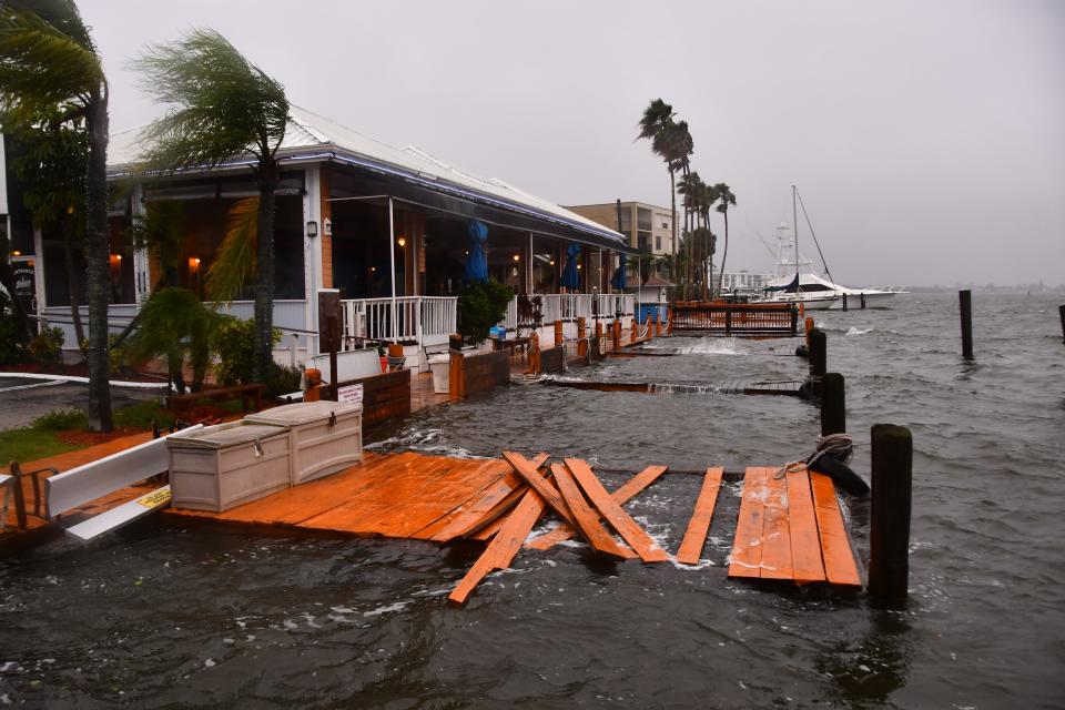
Widespread flooding had been the main concern of emergency management and law enforcement officials. But early reports indicate that the fears of extensive damage did not materialize.
"The overnight report exceeded our best hopes," Brevard County Communications Director Don Walker said early Thursday.
The latest development: Live updates: Hurricane Ian and Brevard, how the storm will affect the Space Coast on Thursday
Scenes from the shelter: 'I'm nervous': Some Brevard residents hunker down for Hurricane Ian in county shelters
County officials received few reports of major damage and no reports of flooding in homes during the overnight hours, Walker said.
Brevard County Emergency Management Director John Scott, though, cautioned that early reports of little major flooding or damage from Hurricane Ian were promising, but an "incomplete picture."
"My expectation is that will tick up," as more reports come in from various parts of the county, Scott said during a Thursday morning briefing to county emergency operations teams.
Brevard County officials on Thursday morning asked residents to reduce water usage, as rains continued from Ian.
Brevard County Utilities said residents are asked to reduce water usage, especially flushing toilets, doing laundry and taking long showers.
Limiting water usage will help reduce the chances of backups into residents' homes, and into the streets and rivers.
Early damage reports
Walker said these were among the initial reports of impacts from Ian:
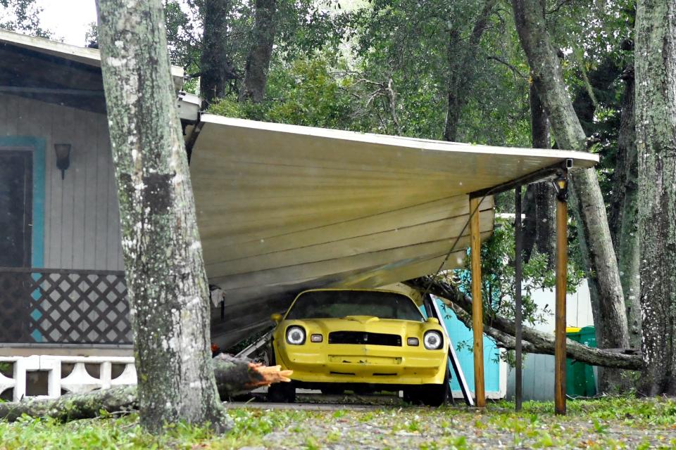
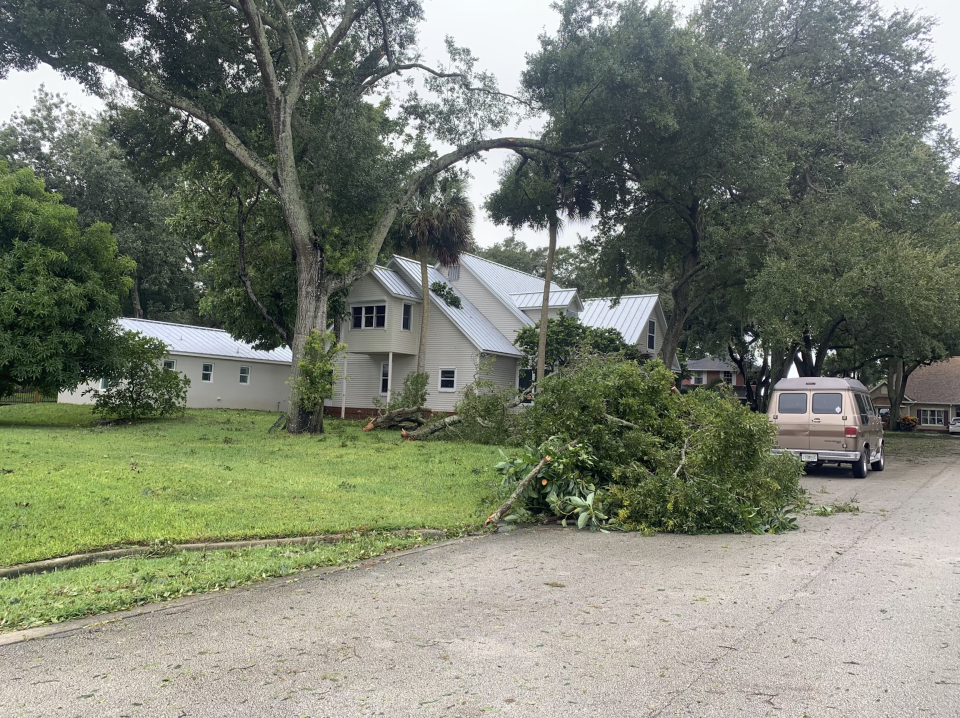
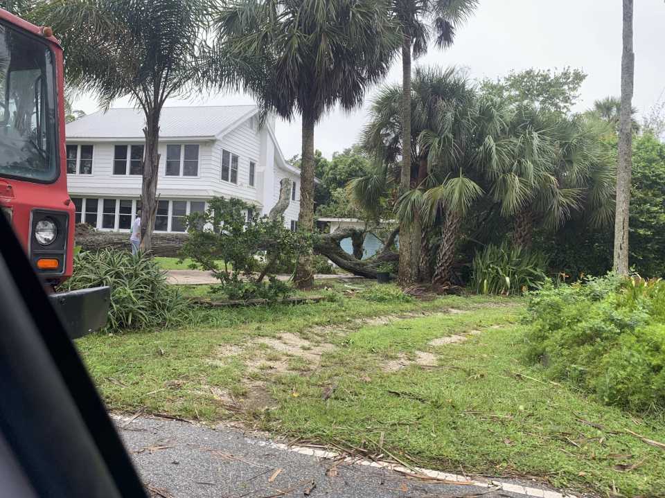
Structure damage: A house lost a roof in Barefoot Bay and a carport was damaged north of Cocoa.
Power lines down: Reported in scattered areas of Cocoa Beach, Melbourne, Satellite Beach and Viera.
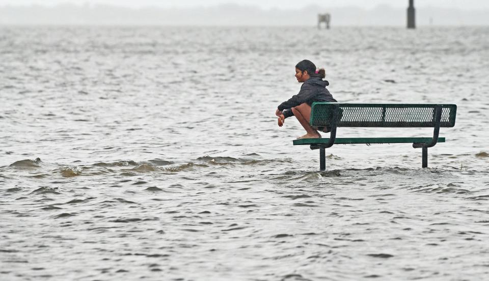
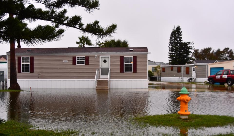
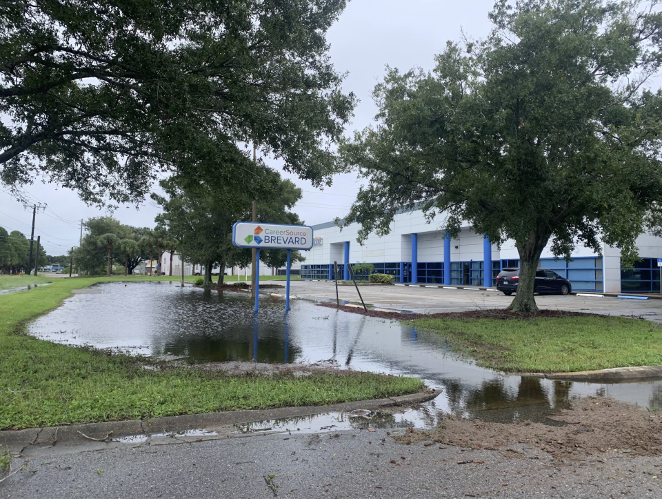
Road flooding: On U.S. 1 in Mims, along Indian River Drive in Cocoa, on side streets in Satellite Beach, and near the on and off ramps between State Road 528 and State Road 520.
Tree fires caused by power lines: In Grant-Valkaria and Indian Harbour Beach.
Walker said State Road 520 was underwater Thursday morning at the State Road 528 interchange. Up to 3 feet of water was reported on the roadway on State Road 520 at the onramps to State Road 528. Traffic on State Road 528 itself was not impeded in either direction, he said. Officials were warning people to avoid the intersection, and find alternate routes to the Beachline.

Crews from the Florida Department of Transportation on Thursday morning were inspecting roadways for flooding and potential damage, Walker said.
Traffic lights also were out throughout the county.
For example, as of Thursday morning, 10 traffic signals across the city of Melbourne remained disabled or on “flash mode” from Ian’s winds, said Cheryl Mall, a city spokesperson.
As Ian approached the Space Coast, most of the heavy rains were in the northern part of Brevard and into Volusia County.
The National Weather Service in Melbourne reported that 6 to 9 inches of rain fell overnight across the Space Coast.
"This is a big rain event," Brevard County Emergency Management Director John Scott said during a Facebook Live update, as the storm approached.
Cocoa resident Mark Fink found his storm experience to be pretty mild.
He was reflecting on the encounter with Ian on Thursday, as he walked his dog along Indian River Drive, near heavy flooding south of Blacks Road.
Fink said he would never have bought a home along the low-lying parts of the roadway and chose his home specifically for the high ground.
“We anticipated it pretty well," Fink said. "My whole backyard’s a big lake now. You could canoe in it."
Widespread power outages
More than 30% of Florida Power & Light Co.'s customers in Brevard experienced power outages during the storm.
As of 9 a.m. Thursday, FPL reported that just over 100,000 of its more than 330,000 Brevard customers had power outages. Of those, 58,640 were still without power, and 41,520 have had their power restored.
Statewide, FPL said, in the 35 counties it serves, 1,770,670 of its 5,269,362 customers had outages. Of those, 1,168,890 were still without power, and 601,780 had their power restored.
"We're responding to Hurricane Ian as it impacts parts of Florida," FPL said in a message to customers posted on its website. "Crews are restoring power in between weather bands, as conditions allow. Remember to stay far away from flooding, downed power lines and debris."
FPL's restoration workforce totals more than 19,000, including mutual assistance from 30 states. FPL said it is operating 37 staging, parking and processing sites around the state to help speed restoration.
Shelters and environmental impacts
Brevard County opened storm shelters Wednesday in Melbourne, Sharpes and West Melbourne. Walker said there were a total of 218 people and 29 pets staying at the shelters during the storm.
The sites had a total capacity of 1,856.
Still to be determined is Ian's impact to local beaches, the lagoon, sewer systems and other infrastructure.
County officials did not anticipate much beach erosion, and the beaches were in good shape to begin with, because of recent county projects to restore sand eroded from past storms.
But Thursday's high tide — around noontime — would obscure the true damage until the surf recedes. Sand swiped away by storms typically is taken just offshore and forms shoals. Tides bring most of the sand back to the beach with in a few weeks.
Biologists say the influx of freshwater to the lagoon could trigger algae blooms, but also say that's very difficult to predict.
Also, while storage capacity for flood waters was in good shape before the storm, Ian lifted most parts of the St. Johns River by about a foot, pushing the river height to greater than 90th percentile levels, increasing the flood risk from future storms.
Be careful out there
During a Facebook Live update Wednesday afternoon, Brevard County Sheriff Wayne Ivey urged residents to be careful, as they start going about their business after storm's impacts subsiding.
"We could have downed power lines. We could have any type of debris out. Obviously, snakes. Everything else would be displaced," Ivey said. "So be aware of your surroundings."
Meanwhile, Walker said the Brevard County Sheriff's Office is sending a team to assist in Lee County on Florida's west coast, where Hurricane Ian roared ashore as a strong Category 4 storm Wednesday, causing catastrophic damage and flooding.
In assessing the storm's impact on Thursday morning, Indialantic Mayor Dave Berkman said, other than about 95% of his town still being without electricity after Ian’s overnight gusts, there were no major problems to report.
"We’ve got lots of palm fronds down, a few trees. But, overall, we came out very well,” Berkman said. “Basically, we dodged a bullet."
J.D. Gallop, Rick Neale, Tyler Vazquez and Jim Waymer contributed to this report.
Dave Berman is business editor at FLORIDA TODAY. Contact Berman at dberman@floridatoday.com. Twitter: @bydaveberman.
Support local journalism and journalists like me. Subscribe today.
This article originally appeared on Florida Today: Ian loses intensity before getting to Brevard, but still drenched us

