Hurricane Ian: Collier and Lee both under hurricane warnings as of 5 p.m. update
Editor's Note: As a public service, the Naples Daily News is making its storm coverage free to readers as long as the region is threatened. To help us continue keeping you informed, please consider supporting us with a subscription.
NATIONAL HURRICANE CENTER STORM SURGE RISK MAP
INSURANCE CHECKLIST BEFORE THE HURRICANE STRIKES
9:28 p.m. Naples airport will close at 10 p.m.
Naples Airport officials released a press conference late Tuesday stating that due to the anticipated arrival of tropical storm force winds, the airport was scheduled to close at 10 p.m. until further notice.
The Naples Airport Authority anticipates the closure to last throughout Wednesday and into Thursday and will reopen upon the completion of a full airfield inspection.
This schedule is subject to change based on weather conditions or damage, added officials.
8:24 p.m. | U.S. Postal Service suspends mail delivery in SWFL
The U.S. Postal Service Florida 2 District has announced a temporary suspension of mail delivery and retail operations in Central and Southwest Florida until further notice due to the approach of Hurricane Ian. The safety of our employees and our customers is a priority for the Postal Service.
6:20 p.m. | RSW to stop operations at 9 p.m.
Southwest Florida International Airport announced all operations will cease at 9 p.m. Tuesday.
All airlines have canceled their flights for Wednesday. Airport officials said some carriers have tentative plans for resuming flights on Thursday; however, it will depend on weather conditions.
Earlier Tuesday morning, Airport spokesperson Vicki Moreland said the airport had been preparing for the storm and would update the public on any incoming flight cancelations or delays.
5:13 p .m. Ian's track shifting more toward SWFL
The forecast for the eye wall of Hurricane Ian has moved a little closer to the Fort Myers area, and meteorologists are calling this a dangerous storm that could cause more impacts locally that Charley, Wilma or Irma.
Those three hurricanes have set the mark for this coast in recent decades. All were major hurricanes and made landfall in Lee or Collier counties.
Storm surge is expected to be the biggest threat, and meteorologists are calling for upwards of 12 feet of surge.
The NHC extended hurricane warnings southward to Chokoloskee. Collier had previously been under a hurricane watch.
4:58 p.m. Marco Island evacuations
Marco Island has issued a mandatory evacuation ahead of Hurricane Ian.
"Given most recent estimates of storm surge predicted to be 6-9 feet and continuing to increase, conditions warrant an evacuation," read the release from the city. "There is a potential threat to life and property. Now is the time for residents to leave the Island."
The threat is not yet imminent, officials say, but it's fewer than 36 hours until the island becomes subject to 4-7 feet of storm surge, flooded roads and power outages.
City officials say now is the time for residents to consider leaving the island and head inland toward Florida's east coast.
They add this is also the time to prepare for a potential mandatory evacuation.
The city won't close the Jolley Bridge or block exits from the Island.
4:33 p.m.. Collier County orders mandatory evacuations for Zone A
Collier County has issued a mandatory evacuation for Zone A.
Generally, Zone A is the coastal area south and west of U.S. 41.
Dan Summers, the county's director of emergency services, announced the evacuation order at a press conference Tuesday afternoon.
With the announcement, he said, the county will open more emergency shelters. However, Summers said they should be "absolutely your last resort," encouraging residents to stay with friends, family, or even in hotels inland.
Three additional shelters are opening.
Two will open at 5 p.m. at Gulfcoast and Immokalee high schools.
The other will open at 6 p.m. at Golden Gate.
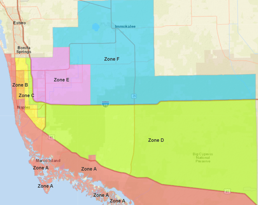
The unusualness of the storm led the county to open more shelters and call for the evacuation for Zone A, Summers said.
Although it's outside the cone of the hurricane, the county still faced a coastal storm warning, a tropical storm warning, a hurricane watch, a flood watch and a tornado watch.
"We want to remind everybody to pay attention to this weather, conditions," Summers said.
The county, he said, has opened its emergency operations center and it's initially staffed at 60
While it appears so much of the state will be affected by the storm, Collier appears fortunate "for this near miss," Summers said.
"All our eyes are north of us," he said.
4:03 p.m. Lots of concern about storm surge
Storm surge is going to be an issue for coastal Lee County as levels could reach upwards of 12 feet above sea level.
Not all of the county will get 12 feet, only the most vulnerable areas.
“It’s extending along the Caloosahatchee River as well,” said Jennifer Hubbard, a meteorologist with the National Weather Service in Ruskin. “People who live well away from the coast are getting a storm surge warning. The winds will push the water up the river and will cause it to flood.”
Storm surge predictions include tidal phases to show the total amount of water above sea level, Hubbard said.
Seas were relatively calm off Sanibel just before 4 p.m. Tuesday, according to the Sanibel Island Live Beach Cam.
2:23 p.m. | Insurance checklist before the storm strikes
Insurance coverage will be a big deal with Hurricane Ian tracking toward Southwest Florida.
Now is the time to review a checklist of things you should do for insurances purposes before the storm hits.
1:10 p.m. | All Collier County Publix stores to close at 6 p.m.
All Publix stores along the west coast of Florida from Key West up to Weeki Wachee, including all stores in Collier, Lee, Hendry and Charlotte counties, will close at 6 p.m. Tuesday and reopen at normal business hours Friday, Sept. 29.
12:50 p.m. | Lee, Collier counties postpone high school football games
The Lee and Collier County school districts announced that football games will not be played on Friday with Hurricane Ian expected to make landfall later this week.
"Since teams cannot safely prepare for a game at the end of the week, all our Friday night games are postponed," Lee County School District spokesman Rob Spicker said in an email.
The tentative plan in Lee County is for the games to be played on Monday, according to Spicker. However, games will only be played on Monday if the teams have been able to hold three practice sessions leading up to the game.
11:38 a.m. | Collier announces schools closed through Thursday
The Collier County School District announced its schools will remain closed through Thursday. It will be posting updates on its website at collierschools.com/hurricane.
CCPS will be CLOSED Tuesday (9/27) & Wednesday (9/28). Forecasted storm effects = heavy rain, potential flooding & high winds. According to @NWSNHC, there is substantial risk for rapid storm intensification that could affect severity. Full update: https://t.co/ru8eriGa3X pic.twitter.com/dpXQDVcFKt
— Collier County Public Schools (@collierschools) September 26, 2022
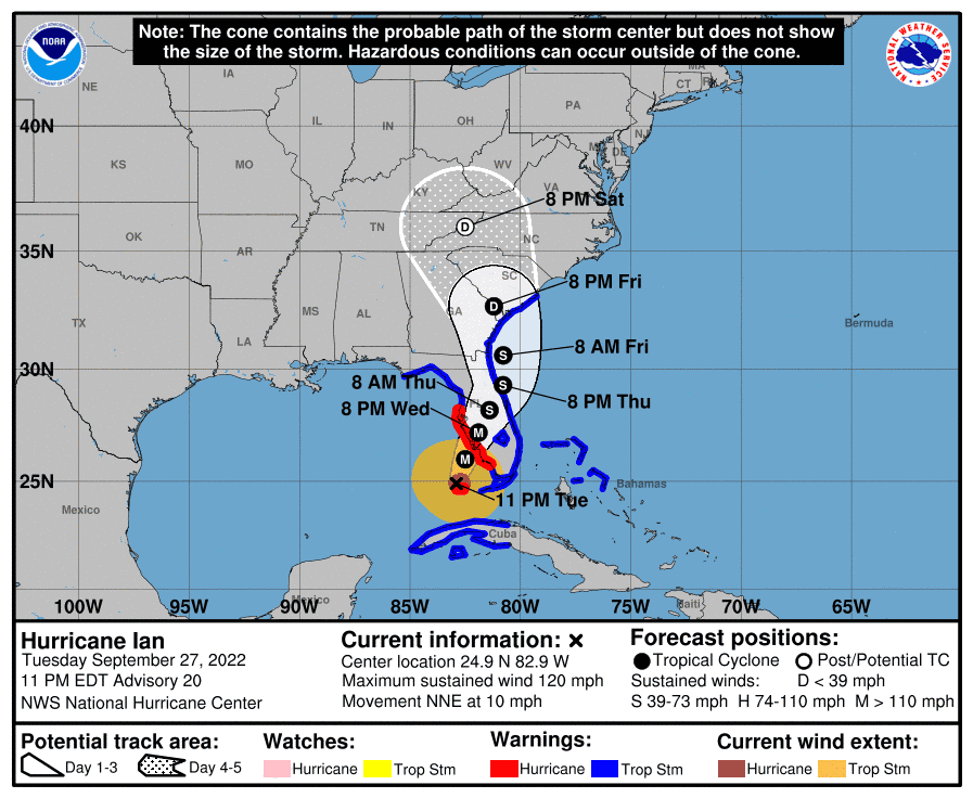
11:08 AM | Ian continuing to strengthen, work its way up the Gulf
Hurricane Ian is plowing its way up the Gulf of Mexico after it emerged from Cuba and into open waters early Tuesday, and it's headed more toward the Fort Myers area.
The 11 a.m. National Hurricane Center advisory calls for tropical storm conditions in Lee County, with upwards of 24 inches of rain in localized areas.
Conditions are expected to deteriorate throughout the day and last for 36 hours or more.
Tropical storm force winds are likely for the Lee County area, and hurricane-level winds could push onshore during heavy rain bands, meteorologists say.
Storm surge had been predicted to been 4 to 5 feet above sea level for the Fort Myers area, but that figured has been raised to 8 to 12 feet.
High tide at 2.7 feet above sea level will hit the Sanibel Lighthouse at 1:56 a.m.
A hurricane watch has issued for south of Bonita Beach to Chokoloskee.
10:44 AM | Evacuation tip, power outages anticipation
Florida Emergency Management Director Kevin Guthrie said Tuesday that potential power outages can be expected statewide. He also said those looking to leave the storm's path may not have to go far.
"Many people in the Southwest Florida area, your best bet is going to be evacuate across the state," Guthrie said. "Just go straight across the state to Broward, Miami-Dade, Palm Beach."
10:43 AM | Governor talks about storm and state prep
Gov. Ron DeSantis said flooding from Hurricane Ian was likely across much of west Florida. He also raised the possibility that after landfall, a weakening Ian would continue to march across Central Florida before exiting somewhere along the state’s Atlantic Coast.
“By and large, we’re looking at really, really major storm surge up and down the west coast of Florida,” DeSantis said.
The state has 5,000 Florida National Guard members in place to assist with the storm and its aftermath. Another 28,000 utility personnel also have been deployed in Florida to help with power restoration, DeSantis said.
10:23 AM | Collier opens five shelters ahead of Hurricane Ian
Collier County will open five shelters for voluntary evacuation as Hurricane Ian draws closer to Southwest Florida.
Shelters will open at 5 p.m.
They include one for seniors and others with special needs at Palmetto Ridge High School.
This shelter is only for those who have preregistered with Emergency Management.
More on evacuations: Evacuation orders have been issued for Florida counties as Hurricane Ian nears. See the list.
Nearly 1,000 people are preregistered in Collier County, said a health department spokesperson.
Additionally, shelters will open at four middle schools: Oak Ridge, Corkscrew, Golden Gate and Immokalee.
"Residents must come prepared with their bedding, their food, and their comfort items," said Dan Summers, the county's director of Emergency Services.
10:09 AM | What they are talking about north of here
Reporter Charles Runnells spent some time in Punta Gorda on Monday talking to residents about any angst they might be having regarding the approach of Hurricane Ian. There's been some comparisons being made between the path Ian is taking and the path Charley took in August of 2004.
9:51 AM | Potential timeline for Hurricane Ian
When will Hurricane Ian affect Southwest Florida? Here's a projected timeline, based on NWS and NHC forecasts:
2 a.m. Wednesday – Hurricane Ian at Category 4, with winds of 130 mph, due west of Everglades National Park
2 a.m. Wednesday – Hurricane-force winds possible in Collier County
8 a.m. Wednesday – Hurricane-force winds possible in Lee County
2 p.m. Wednesday – Hurricane Ian at Category 3, with winds of 125 mph, due west of Fort Myers
5 a.m. Thursday – Possible landfall in north Manatee County or the Tampa Bay Area
6:45 a.m. | Collier County closures, cancellations due to Ian
Here's a running list of closures, cancellations, and postponements due to Hurricane Ian. Have information to add to the list? Email dosborn@gannett.com and we'll include it.
Hurricane Ian Live updates: Live Updates: Hurricane Ian's path, predictions and Florida Gov. DeSantis' latest
More: Collier, Lee schools closing ahead of Hurricane Ian
6 a.m. | Marco Island declares state of emergency
The city of Marco Island is now under a state of emergency due to Hurricane Ian. No evacuation orders have been issued for residents but that could change. There are no hurricane shelters on Marco Island.
5:05 A.M. | The Latest on the track of Hurricane Ian
According to Tuesday's 5 a.m. advisory by the National Hurricane Center, Hurricane Ian's maximum winds have increased to 125 mph, making it a Category 3 storm. It is moving north near 12 mph as it continues to strengthen.
A turn to the north-northeast in the direction of Southwest Florida and a reduction in Ian's speed is expected tonight and Wednesday.
The NHC extended the hurricane warning south to Bonita Beach, meaning hurricane conditions are expected in Lee County as Ian inches closer.
Hurricane-force winds extend outward up to 35 miles from Ian's center and tropical-storm-force winds present up to 115 miles from the storm's core.
Helpful hurricane resources and links
Get your home ready: Here's how to prepare your home for a hurricane, from well in advance to just before a storm's arrival
Need to prepare for a hurricane? Here's what you should have in a disaster supply kit
Hurricane preparedness list: If a storm is coming, here is what you need to do now
Video: Helpful tips for a hurricane survival kit
Hurricanes, typhoons, and cyclones: What’s an invest and why do they keep saying tropical cyclone?
This article originally appeared on Naples Daily News: Hurricane Ian Updates: Naples, Florida under tropical storm watch

