Hurricane Ian Live Updates: St Johns County officials provide update on flooding in St Augustine
The Florida Times-Union has made this article free of charge for all readers in the interest of public safety. Please consider supporting local journalism with a digital subscription.
Quick Northeast Florida Hurricane Ian links:
Hurricane Ian: See the latest forecast, tracking map
Shelter status: Hurricane shelters open across Northeast Florida
Hurricane updates: Sign up to get the latest news sent to your phone
High school football: Florida games postponed, canceled due to Hurricane Ian
What's open? Duval, Jacksonville area closings and cancellations
Hurricane evacuation zones: Evacuation information for Duval, Clay, Nassau and St. Johns counties.
Earlier: See more updates from our live blog on Wednesday
9:50 p.m. | 2 dead in Putnam County crash linked to Hurricane Ian
A Putnam County man and woman became two of Northeast Florida's first known Hurricane Ian-related fatalities trying to navigate across local roads Thursday evening in standing water. --Scott Butler
9:20 p.m. | DeSantis: Over 700 rescued from Hurricane Ian in Charlotte, Lee counties
Florida Gov. Ron DeSantis announced late Thursday that search and rescue teams have rescued more than 700 people in Charlotte and Lee counties, the locations most directly affected by Hurricane Ian's Wednesday landfall.
Other key statistics included $10 million raised in only 24 hours for the Florida Disaster Fund and more than 20,000 people in hurricane shelters around the state.
8:50 p.m. | Northeast Florida Winn-Dixie, Harveys locations to reopen Friday
The reopening process is scheduled to pick up the pace Friday morning in the Jacksonville area, and Winn-Dixie and Harveys supermarkets are scheduled to reopen as well.
Closed locations in Baker, Clay, Duval, Nassau and St. Johns counties are scheduled to reopen Friday at 9 a.m. For residents in Putnam County, the planned reopening time will be 11 a.m.
8 p.m. | New Hurricane Ian advisory shows storm due east of Northeast Florida
![The National Hurricane Center issued its 8 p.m. advisory for Hurricane Ian on September 29, 2022. [National Hurricane Center]](https://s.yimg.com/ny/api/res/1.2/T0bs3OmeF7jROHxG6.iCDQ--/YXBwaWQ9aGlnaGxhbmRlcjt3PTk2MDtoPTY5Mg--/https://media.zenfs.com/en/the-florida-times-union/081b4c7f123f54c591df922c9448e0a3)
Hurricane Ian is officially passing east of the First Coast this evening in the National Hurricane Center's new 8 p.m. advisory. The storm is continuing its north-northeastward track for now, which has kept its strongest bands offshore during recent hours and sparing Northeast Florida its worst effects. However, Jacksonville remains under a tropical storm warning and a hurricane watch.
The key numbers:
Position: 29.7 N, 79.4 W
Movement: NNE at 10 mph
Maximum sustained winds: 75 mph
Minimum central pressure: 986 mb
If you can't see any local weather warnings here, you'll need to open this story in a web browser.
7:30 p.m. | Jacksonville & Northeast Florida sports events postponed, canceled
Hurricane Ian wiped out dozens of high school and college sports events across the First Coast. Find out the latest on plans for rescheduling. | Read more --Clayton Freeman and Garry Smits
7:20 p.m. | Riding out the storm: JIA flights resume Friday and JTA buses run again
As Hurricane Ian's departure from Florida continues en route toward the Carolinas and Savannah, travelers now have some good news when it comes to air and ground transportation in the Jacksonville area.| Read more --Dan Scanlan
5:45 p.m. | Doughnuts delayed: Hurricane Ian shakes up (slightly) plans for traditional Cinotti's pumpkin treats
Good things come to those who wait.
And fans of Cinotti's Bakery's pumpkin doughnut will have to wait a few extra hours longer on Friday to get the first pumpkin doughnuts of the season out of the Jacksonville Beach bakery's fryer and into the crisp white bakery boxes and bags. | Read more --Gary Mills
5:30 p.m. | Jacksonville International Airport to reopen Friday
After a one-day interruption, Jacksonville International Airport announced Thursday afternoon that reopening is planned for Friday. The TSA security checkpoint opens at 7 a.m. Friday.
5 p.m. | Ian strengthens again, regains hurricane force offshore
![The National Hurricane Center issued its 5 p.m. advisory for Hurricane Ian on September 29, 2022. [National Hurricane Center]](https://s.yimg.com/ny/api/res/1.2/1ZMkjgZAmbNqRs2P8fslcg--/YXBwaWQ9aGlnaGxhbmRlcjt3PTk2MDtoPTY4Nw--/https://media.zenfs.com/en/the-florida-times-union/7dce6c14078e5cf4a6f4092ddcef7804)
The National Hurricane Center issued its 5 p.m. advisory, bumping Ian back to hurricane strength with winds of 75 mph. The hurricane warning has been extended eastward to Cape Fear, North Carolina. Northeast Florida remains under a hurricane watch.
The key numbers:
Position: 29.3 N, 79.9 W
Movement: NNE at 10 mph
Maximum sustained winds: 75 mph
Minimum central pressure: 986 mb
4:30 p.m. | Is your electricity out? See the latest power outages for Northeast Florida
Over 1 million Floridians reported being without power as a result of the hurricane, and about 28,300 of them are Northeast Florida residents. | Read more --Alexandria Mansfield
3:45 p.m. | Nassau County: Residents in evacuation zones urged to leave during low tide
Nassau County officials warned in a Thursday afternoon briefing that the county's risks from Tropical Storm Ian are not yet over, as the system continues its north-northeastward course.
Officials said that residents in evacuation zones A and D should leave during low-tide if they are able. | --Alexandria Mansfield
3:25 p.m. | St. Johns County: More than 300 rescue calls since Wednesday night from Hurricane Ian
Emergency personnel have responded to 300-plus rescue calls since Wednesday night in St. Johns County as officials said Hurricane Ian flooded downtown St. Augustine, Summer Haven, Hastings, Flagler Estates and Matanzas Inlet.
Fire Chief Jeff Prevatt said rescuers are using "high water" vehicles to get into evacuation zones where residents failed to leave and then needed help. | Read more --Beth Reese Cravey
3:05 p.m. | JEA power outages surpass 12,000
Even with Ian's center far from Jacksonville, power outages continue to spread. As of 3 p.m., JEA reported 99 power outages, with 12,115 customers without power.
Here's how to track utility outages across Northeast Florida. | Read more --The Times-Union
2:30 p.m. | Waves build at Jacksonville Beach
While less severe than locations to the south, Duval County's beaches have also seen wild weather from Hurricane Ian, threatening coastal flooding.
2:20 p.m. | Duval Schools to decide this weekend about Monday reopening from Hurricane Ian
Duval County Public Schools will not yet make a determination about whether to reopen schools Monday from Hurricane Ian. That decision is expected to come Saturday.
Schools in the county closed Wednesday and Thursday ahead of the hurricane and will remain closed Friday as well. | Read more --Steve Patterson
2:05 p.m. | National Hurricane Center 2 p.m. advisory: Ian expected to regain hurricane force
![The National Hurricane Center's 2 p.m. advisory for Hurricane Ian on September 29, 2022. [National Hurricane Center]](https://s.yimg.com/ny/api/res/1.2/7y0p3oxDEhd8puocHKwY2A--/YXBwaWQ9aGlnaGxhbmRlcjt3PTk2MDtoPTY5Mg--/https://media.zenfs.com/en/the-florida-times-union/2bdaa4f39e373aebf74368d9fef7572c)
The new advisory is in for Hurricane Ian at 2 p.m. The National Hurricane Center expects that Ian, currently with maximum sustained winds at 70 miles per hour, will return to hurricane force prior to a projected landfall around South Carolina.
Position: 28.9 N, 80.0 W
Movement: NNE at 9 mph
Maximum sustained winds: 70 mph
Minimum central pressure: 987 mb
2:00 p.m. | St. Johns County officials update flooding, conditions
Important Tropical Storm Ian Update - Sept. 29, 2022
Posted by St. Johns County Emergency Management on Thursday, September 29, 2022
1:30 p.m. | Mayor Lenny Curry advises vigilance, flooding could persist
Jacksonville residents could experience flooding in certain parts of the city as late as Sunday, Mayor Lenny Curry advised Thursday afternoon.
Hurricane Ian was downgraded to a tropical storm early Thursday morning, but Curry warned against returning to normal during an afternoon press conference at the city's Emergency Operations Center.
"I want to make clear we're not out of the woods, and you should not let your guard down," Curry said. Read more from Hanna Holthaus here.
1:20 p.m. | Tropical Storm Ian slams St. Augustine
First Coast News anchor Jessica Clark reports about waist-deep water in parts of St. Augustine.
A man arrives at work by boat in St. Augustine. Water is waist deep on Avenida Menendez. Hurricane Ian is slamming St Aug @FCN2go pic.twitter.com/gpzob9U0cX
— Jessica (@JessicaFCN) September 29, 2022
Earlier, she showed video of the seawall in downtown St Augstine.
The water is almost over the seawall in downtown St. Augustine… and we haven’t hit the peak of high tide yet. @FCN2go pic.twitter.com/ttn9Um3ufE
— Jessica (@JessicaFCN) September 29, 2022
1:15 p.m. | St. Johns Town Center mostly quiet and empty
12:30 p.m. | Flash flood warning issued in St. Johns County
The National Weather Service has issued a flash flood warning for southeastern St. Johns County in northeastern Florida until 3:15 p.m.
St. Johns County Emergency Management reported water inundating mobile homes near Holmes Boulevard and State Road 207 Thursday morning. The combination of rainfall and surge is causing flash flooding in the warned area. Between 3 and 7 inches of rain have fallen. Additional rainfall amounts of 2 to 4 inches are possible in the warned area.
Some locations that will experience flash flooding include St. Augustine, St. Augustine Beach, St. Augustine Shores, St. Augustine South, Butler Beach, Crescent Beach, Vilano Beach, Dupont Center and Anastasia.
11:15 a.m. | St. Augustine roads flooding
First Coast News, our news partner, is reporting flooding in parts of St. Augustine. They're also now saying the Bridge of Lions is partially closed.
Water rising in #StAugustine. Please don’t do this. Bridge of Lions partially closed. @FCN2go #HurricaneIan pic.twitter.com/OAnbqZ5UOf
— Renata Di Gregorio (@RenataFCNews) September 29, 2022
And this is what it looked like in Davis Shores a little bit ago.
This is the video I was talking about in my live shot before we had to leave because it got sketchy. Ten mins after (took a while to send) this video the road was completely covered in water. @FCN2go #HurricaneIan https://t.co/yqY9vz0DM7
— Renata Di Gregorio (@RenataFCNews) September 29, 2022
11 a.m. | Latest storm tracking, forecast from National Hurricane Center

Ian's maximum sustained winds picked up a little since the 8 a.m. report. The 11 a.m. advisory says there's "a danger of life-threatening storm surge through Friday along the coast of Northeast Florida, Georgia and South Carolina."
Location: 28.7°N 80.4 W
Moving: NE at 9 mph
Maximum sustained winds: 70 mph
10:45 a.m. | Jacksonville appears on Today Show ahead of storm's arrival
Overnight, a tall sign crashed to the ground at a shopping center on Baymeadows Road near Old Kings Road. First Coast News was there and captured the fall on video, which made its way to the Today Show this morning. Here's a look.
.@KerryNBC joins us on the ground in Florida with a look at the rescues, heroes, and helpers during Hurricane Ian. pic.twitter.com/M8xbZ4gmgk
— TODAY (@TODAYshow) September 29, 2022
10:25 a.m. | Bridge of Lions closes in St. Augustine
First Coast News meteorologist Lew Turner reports that the Bridge of Lions in St. Augustine has closed and that water is pouring over the seawall onto A1A in the historic district. Nearby, reporter Renata Di Gregoria shares video from Davis Shores.
Bridge of Lions closed…
Flooded road… river pouring over seawall.
90 minutes until high tide still. #fcnstorm pic.twitter.com/GmJhwEi8Bv— Lew Turner (@LewTurner) September 29, 2022
Houses here that we’ve seen seem okay in Davis Shores. It’s still very windy and rainy. Earlier I could actually taste some salt from the wind blowing the water up. #HurricaneIan @FCN2go pic.twitter.com/bvo8xPHN5Z
— Renata Di Gregorio (@RenataFCNews) September 29, 2022
9:45 a.m. | Watch storm surge inundate Fort Myers
A Michigan TV journalist reporting from Fort Myers captured the dramatic storm surge there. It's a good reminder of how storm surges work.
I've been capturing video from this webcam in Fort Myers all day and I've put it into a Timelapse. Check out the storm surge rushing in! Crazy. #Ian #flwx pic.twitter.com/lj7a1wThga
— Brennan Prill (@WxBrenn) September 28, 2022
8:40 a.m. | Watch video of rescue from sailboat in Nassau County
The Nassau County Sheriff's Office Marine Unit reported it had rescued two people who were on a sailboat in the Fernandina Harbor at about 8:30 p.m. Wednesday.
No one was injured, but people are being reminded not to head out on boats during dangerous conditions.
The NCSO Marine Unit rescued two people that were on their sailboat in the Fernadina Harbor around 8:30 p.m. Luckily no one was injured but let this be a reminder not to head out on your boat in these dangerous conditions. #hurricaneian #OneNassau pic.twitter.com/5cz35OvqPu
— Nassau County SO (@NCSO_FL) September 29, 2022
8:30 a.m. | FHP: Please stay off the roadways
The Florida Highway Patrol is asking Jacksonville-area drivers to stay off the road today as Ian makes its way to Northeast Florida.
"It is not the time for sightseeing as this storm continues. Our troopers and other first responders are out assisting numerous calls for service," FHP tweeted Thursday morning.
You can monitor road conditions via our traffic gridlock guide.
8 a.m. | Winds drop, Ian a tropical storm
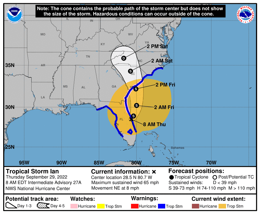
Over the course of 12 hours, Ian's sustained winds have dropped 50 mph, making Ian a tropical storm with sustained winds of 65 mph. The National Hurricane Center says that Ian is producing catastrophic flooding over east-central Florida and is forecast to produce "life-threatening flooding, storm surge and gusty winds" across parts of Florida, Georgia and the Carolinas.
Location: 28.5°N 80.7 W
Moving: NE at 8 mph
Minimum central pressure: 987 mb
Maximum sustained winds: 65 mph
8 a.m. | Trees begin to snap, fall in some areas
Trees are already starting to fall in some areas of Northeast Florida. Emergency Road Access Teams, made up of of JEA utility crews, contractors and others, are out to clear roads to make them passable for first responders and others. You can read more about those teams here.
Trees are falling early…ERAT teams are out all night clearing roads and making sure emergency crews can get through the roads… as the weather gets worse, more trees will fall. @JaxReady @CityofJax @lennycurry #teamwork pic.twitter.com/EVqHqqnkys
— THEJFRD (@THEJFRD) September 29, 2022
7:30 a.m. | 'Calm' before the storm
7:15 a.m. | All flights canceled at Jacksonville International Airport
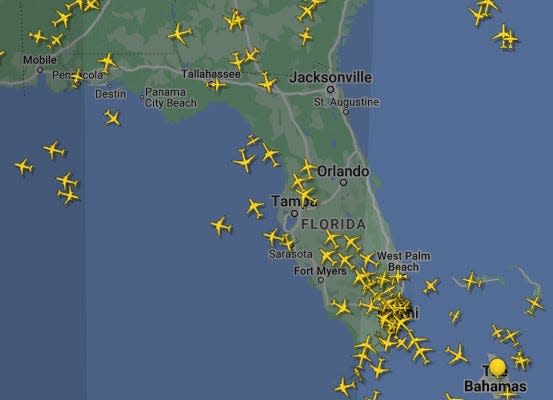
All flights today at Jacksonville International Airport are canceled, the airport announced late Wednesday. Travelers affected by cancellations should contact their airline for rebooking options. (View JIA's flight information.)
At 7:15 a.m., no flights were tracking in Northeast Florida on flightradar24.com.
6:50 a.m. | Winn-Dixie among area stores closed Thursday
All Winn-Dixie stores in Jacksonville are closed Thursday. The same is true for most parts of Northeast Florida. You can check if your own store is impacted on the Winn-Dixie website.
And you can see the status of some other large retailers here.
6:10 a.m. | Power outages in pockets of Northeast Florida
JEA is reporting about 7,300 customers without power right now. You can track outages on JEA's website.
FPL is reporting about 6,450 customers without power now in St. Johns County and about 250 customers in Nassau County. You can also check outages on FPL's website.
Clay Electric is reporting about 4,300 customers without power in Clay County. You can track those outages on Clay Electric's website.
5:30 a.m. | The calm before the storm
5:15 a.m. | Mayor, city brace for Hurricane Ian Thursday
As Jacksonville braces for more severe impacts Thursday from Hurricane Ian, Mayor Lenny Curry stopped short of issuing mandatory evacuations late Wednesday, but reiterated his earlier statement that Ian could bring flooding similar to the city's experience with recent hurricanes Matthew and Irma.
Curry urged residents to stay off the roads once weather begins to deteriorate during Thursday, a process expected to worsen during the morning hours. | Read more --Hanna Holthaus
5:00 a.m. | Updated tracking map, forecast for Hurricane Ian
Here's the latest update on Hurricane Ian from the National Hurricane Center.


Read live updates from Wednesday, Sept. 28, here.
This article originally appeared on Florida Times-Union: Hurricane Ian Jacksonville, Thursday: What you need to know about impact, path

