Hurricane Ian Wednesday updates: Jacksonville opens 4 shelters as storm moves closer
The Florida Times-Union has made this article free of charge for all readers in the interest of public safety. Please consider supporting local journalism with a digital subscription.
Quick Northeast Florida Hurricane Ian links:
Hurricane Ian: See the latest forecast, tracking map
High school football: Florida games postponed, canceled due to Hurricane Ian
What's open? Duval, Jacksonville area closings and cancellations
Hurricane evacuation zones: Evacuation information for Duval, Clay, Nassau and St. Johns counties.
9:20 p.m. | Mayor closes beaches due to Hurricane Ian
Mayor Lenny Curry announced the closure of Jacksonville's beaches due to Hurricane Ian on Wednesday evening, in combination with officials in Atlantic Beach, Neptune Beach and Jacksonville Beach. | Read more --Clayton Freeman
7:55 p.m. | National Hurricane Center issues 8 p.m. Hurricane Ian advisory
![The National Hurricane Center issued its forecast cone and advisory for Hurricane Ian at 8 p.m. on Wednesday, September 28, 2022. [National Hurricane Center]](https://s.yimg.com/ny/api/res/1.2/qVSVjFqIFl4iUsnaOxtgTg--/YXBwaWQ9aGlnaGxhbmRlcjt3PTk2MDtoPTY5Mg--/https://media.zenfs.com/en/the-florida-times-union/0242a6cc898976d57ff9e5ad7dd28778)
The National Hurricane Center issued its intermediate 8 p.m. advisory for Hurricane Ian. The system's intensity has diminished upon landfall to sustained winds of 115 miles per hour, still Category 3 status. Watches and warnings are unchanged. Here's the situation:
Location: 27.2°N 81.7 W
Moving: NNE at 8 mph
Minimum central pressure: 960 mb
Maximum sustained winds: 115 mph
If you can't see any local weather warnings here, you'll need to open this story in a web browser.
7:15 p.m. | What is the situation with Jacksonville-area hospitals as Hurricane Ian's effects soon to be felt?
Jacksonville-area hospitals remained open Wednesday as Hurricane Ian approached, although some of them have limited procedures and visitation and closed specialty centers. | Read more --Beth Reese Cravey
7 p.m. | Clearing the way: Emergency road teams allow Jacksonville firefighters to respond amid storm
Just before Hurricane Ian crossed the state into the Jacksonville area, the city's Fire and Rescue Department strategically placed special teams across town to help slice or shove through road blockages so rescue crews could get to victims.
| Read more --Dan Scanlan
6 p.m. | San Marco shop readies for Hurricane Ian
![Baylie Berry, assistant manager of The White Magnolia Bridal Collection in flood-prone San Marco used black plastic trash bags Wednesday, September 28, 2022, to protect the shop's sample wedding gowns from possible flood waters resulting from Hurricane Ian. Customer gowns were taken out of the store to higher ground. [Teresa Stepzinski/Florida Times-Union]](https://s.yimg.com/ny/api/res/1.2/8EbtQdGgOiKNeUo6mPBQSQ--/YXBwaWQ9aGlnaGxhbmRlcjt3PTk2MDtoPTcyMA--/https://media.zenfs.com/en/the-florida-times-union/3af320d293538be44d10e2e0340df2b4)
The staff of The White Magnolia Bridal Collection shop in flood-prone San Marco spent Wednesday moving customer wedding gowns and veils to higher ground, and using heavy-duty, black trash bags to protect sample gowns in the store from possible flood waters resulting from heavy rainfall produced by Hurricane Ian.
They also cobbled together makeshift flood barriers using sandbags, plexiglass, trash bags and duct tape to keep water out of the store.
"We don't want our brides to have any damage to their dresses. We're preparing for the worst but hoping for the best. Obviously, with Ian, we're trying to over-prepare because of the flooding that we get in San Marco even when there isn't a hurricane," Shannon Woodill, store marketing director, said.
The store will be closed Thursday and Friday, she said. | --Teresa Stepzinski
5 p.m. | National Weather Service issues 5 p.m. advisory on Hurricane Ian
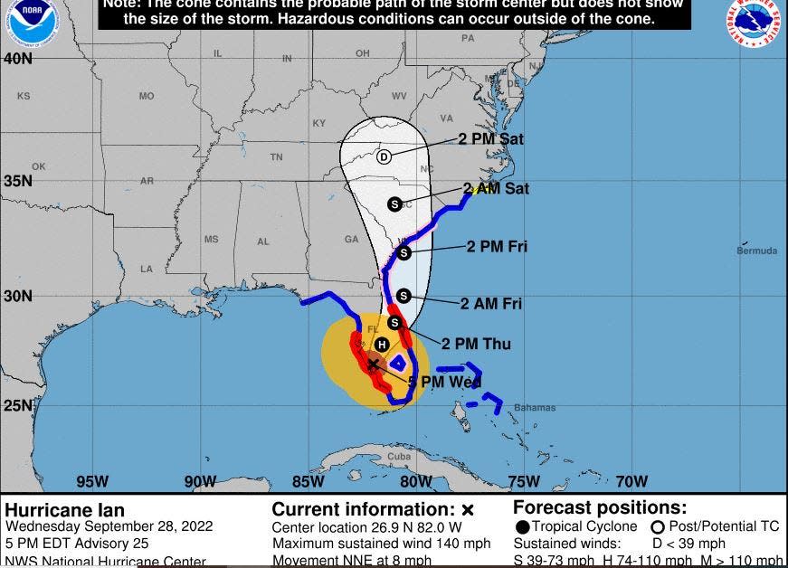
The 5 p.m. advisory is here. Watches and warnings did not change for Northeast Florida, which remains under a hurricane watch. Hurricane Ian's maximum sustained winds have diminished to 140 miles per hour upon landfall, but it remains a powerful Category 4 hurricane. Here's the situation:
Location: 26.9°N 82.0°W
Moving: NNE at 8 mph
Minimum central pressure: 945 mb
Maximum sustained winds: 140 mph
4:40 p.m. | National Weather Service Jacksonville Office updates Hurricane Ian surge projection
Storm surge remains a concern for Northeast Florida residents near the coast and the St. Johns River, and the National Weather Service issued revised forecasts for Hurricane Ian's surge potential.
Along the Atlantic Coast and Intracoastal Waterway: 4-7 feet, similar to Hurrican Matthew (2016)
Along the St. Johns River and estuaries: 3-5 feet, similar to Hurricane Irma (2017)
4:30 p.m. | UPDATED: Publix among retailers to announce Northeast Florida store closures ahead of Hurricane Ian
Northeast Florida Publix locations plan to operate under "modified hours" for the remainder of the week. | Read more --Alexandria Mansfield
4:05 p.m. | Nassau County restricts beach driving during Hurricane Ian
Nassau County emergency management officials prohibited driving on the beach for safety reasons during Hurricane Ian in unincorporated areas of Amelia Island, while city officials in Fernandina Beach did the same at Seaside Park. Northeast Florida's coastline remains under a hurricane watch.
St. Johns County had issued a similar ban on beach driving ahead of Hurricane Ian on Tuesday.
3:50 p.m. | VIDEO: Jacksonville Beach pier shows conditions near outer bands of Hurricane Ian
Times-Union photographer Corey Perrine shot this video Wednesday afternoon, with Hurricane Ian still far from the First Coast.
3:15 p.m. | Garbage collection services suspended for some Northeast Florida areas ahead of Hurricane Ian
Due to potential impacts of Hurricane Ian, some area garbage, recycling and yard debris collection schedules will be impacted around the First Coast. | Read more --Alexandria Mansfield
3:10 p.m. | Jaguars coach Doug Pederson talks Hurricane Ian, Trevor Lawrence
The Jags' coach spoke Wednesday about the coming storm and much more ahead of the team's trip to Philadelphia.
2:35 p.m. | As Hurricane Ian nears landfall, Northeast Florida officials scramble to prepare region
As the eyewall of Hurricane Ian began moving onshore at Sanibel Island near Fort Myers at noon Wednesday — the most significant tropical threat to Florida's West Coast in decades — government and emergency officials in Northeast Florida scrambled to prep residents for the storm's slow crawl across the peninsula, where it's forecast to weaken before punching through the East Coast and out into the Atlantic sometime Thursday evening as a tropical storm. | Read more --Nate Monroe, Katherine Lewin, Alexandria Mansfield and Hanna Holthaus
2:20 p.m. | NOAA: Naples station reports record water level for Hurricane Ian
At Naples, southeast of Hurricane Ian's eyewall, water levels are rising rapidly.
A NOAA Ocean Service post from Twitter: "Water levels in Naples, Florida have reached more than 6' above normal high tide ahead of #Ian's landfall of, eclipsing the station record of 4.25 feet set during Hurricane Irma in 2017. NOAA is continuing to monitor water levels throughout the region and is beginning to see rise at Fort Myers, where our station is recording 1.3 feet above normal high tide."
A live NOAA graphic of coastal flooding is available here.
2:10 p.m. | St. Johns County suspends recycling, garbage and yard waste for Thursday and Friday
St. Johns County officials have suspended collection of household garbage, yard waste and recycling for Thursday and Friday because of Hurricane Ian. Officials requested that residents secure garbage and recycling containers during the storm.
The county expects to release information on rescheduled collection plans when available. The suspension also applies Thursday and Friday for St. Augustine and St. Augustine Beach.
2 p.m. | NHC issues new 2 p.m. Hurricane Ian advisory, winds still 155 mph
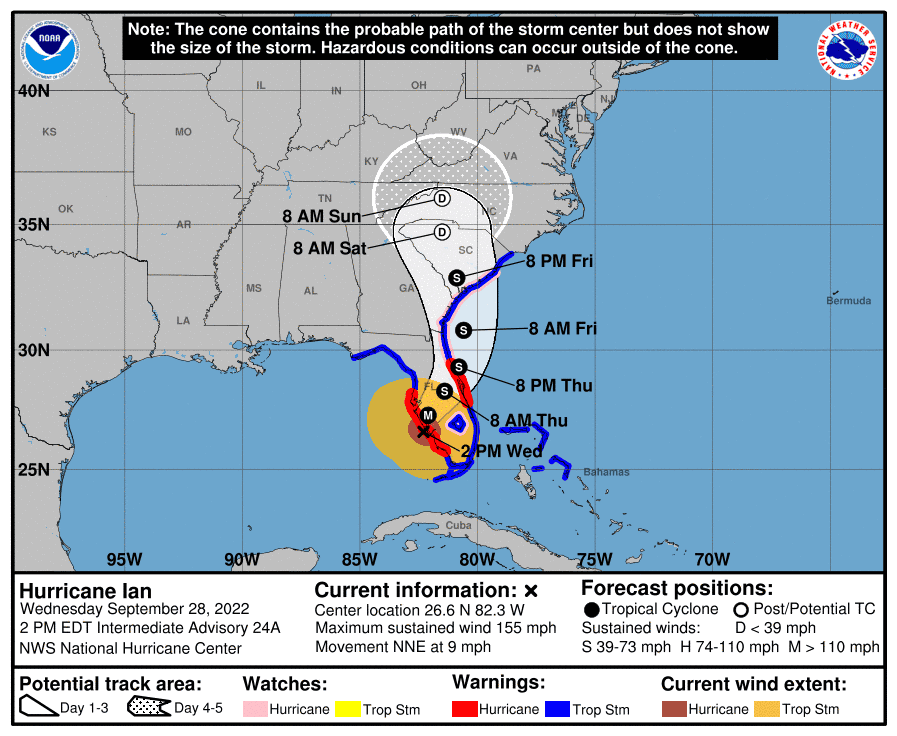
The 2 p.m. advisory is out from the National Hurricane Center, as Hurricane Ian continues to buffet the state's southwestern coast. Here's the situation:
Location: 26.6°N 82.3°W
Moving: NNE at 9 mph
Minimum central pressure: 937 mb
Maximum sustained winds: 155 mph
The center is in the process of making landfall. Northeast Florida remains under a hurricane watch.
1:55 p.m. | Hurricane Ian halts Jacksonville buses, some flights and transportation services
The Jacksonville Transportation Authority is shutting down its mass transit and specialty services due to the approach of Hurricane Ian.
The JTA's bus routes, ReadiRide, First Coast Flyer and Express Select Services will continue to operate on a regular schedule as long as weather permits until 8 p.m. Wednesday when they will be suspended. | Read more --Dan Scanlan
1:40 p.m. | Hurricane Ian: Volunteers help Ken Knight Drive neighbors on Jacksonville's Northside
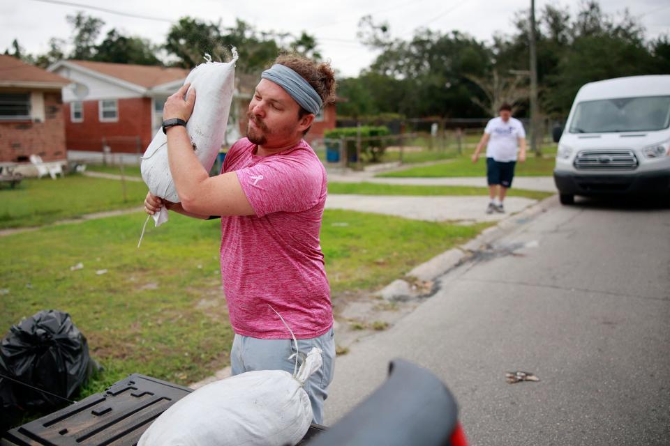
Neighbors and volunteers went door-to-door distributing sandbags along Jacksonville’s flood-prone Ken Knight Drive as preparations for Hurricane Ian accelerated Wednesday.
“This is the first help here we’ve got,” said Alton Gordon. | Read more --Steve Patterson
1:30 p.m. | Sarasota officials: Hurricane Ian winds prevent emergency vehicle response
In the state's southwest, Hurricane Ian's winds are disrupting emergency services. Emergency management officials there posted minutes ago: "Winds are now at sustained speeds of 45 mph in Sarasota County. Emergency vehicles are no longer responding to calls in Sarasota County as it is not safe on the roads. Use this time to shelter in place."
1:15 p.m. | 18 inches: National Weather Service Jacksonville office warns of flood threat from Hurricane Ian
Although Jacksonville does face a threat from the winds of Hurricane Ian, the National Weather Service has particularly emphasized concerns about heavy rainfall. The NWS Jacksonville office warned Wednesday afternoon that Northeast Florida locations could receive as many as 18 inches of rain.
🌧️ Rounds of heavy rainfall beginning today and lasting through Friday
📏6-15" storm total rainfall, local 18" in NE FL
📏 5-9" storm total rainfall, locally higher in SE GA pic.twitter.com/YmmGPinb6v— NWS Jacksonville (@NWSJacksonville) September 28, 2022
1 p.m. | IKEA, Starbucks among Northeast Florida store closures announced ahead of Hurricane Ian
The approach of Hurricane Ian is also altering plans for multiple Jacksonville-area retailers, restaurants and other businesses. | Read more --Alexandria Mansfield
12:50 p.m. | St. Johns County: Today's final Hurricane Ian sand drop-off at 1 p.m.
St. Johns County emergency management authorities announced that today's last new sand drop-off will take place at 1 p.m. for those seeking sandbags.
Six locations in St. Johns County began providing sandbags to county residents Tuesday morning.
12:43 p.m. | Follow updates from Fort Myers as Hurricane Ian makes landfall at Sanibel, Captiva
In this hour, Hurricane Ian is making landfall with sustained winds of 155 miles per hour at Sanibel and Captiva Islands, as announced by the National Hurricane Center.
Within the USA Today Network, the Fort Myers News-Press staff is tracking live updates from the eye of the hurricane. See the latest news on the ground from Lee County. | Read more --Fort Myers News-Press
12:36 p.m. | Furyk & Friends golf tournament at Timuquana getting ready for Hurricane Ian's arrival — and departure
They’re battening down and getting prepared at the Timuquana Country Club to keep next week’s Constellation Furyk & Friends PGA Tour Champions in play.
While none of the tournament structures such as hospitality areas and bleachers are being taken down, other precautions are being made for the arrival and in the aftermath of Hurricane Ian, which is expected to bring tropical-force winds to the First Coast by Thursday morning. | Read more --Garry Smits
12:30 p.m. | National Hurricane Center emphasizes tornado risk
Forecasters are also warning of the risk of tornadoes from Hurricane Ian, even far from the center of circulation. The National Weather Service Storm Prediction Center issued an updated assessment of tornado risk from the storm's landfall.
Eastern and central Florida, including Daytona and the Space Coast, are indicated with the most severe risk, but Northeast Florida could also face a tornado threat.
Another aspect related to #Ian is the tornado risk for the Florida peninsula in outer rainbands away from the immediate center. @NWSSPC currently has an enhanced risk for tornadoes focusing along the E FL coastline near Daytona & West Palm Beach.
More: https://t.co/O0OFBubZVj pic.twitter.com/YW0rdzzM9c— National Hurricane Center (@NHC_Atlantic) September 28, 2022
12:20 p.m. | Shelters now open in Nassau County
Nassau County's two storm shelters for Hurricane Ian are now open, effective at noon. Those locations are as follows:
Special needs: Hilliard Middle-Senior High School, 1 Flashes Drive, Hilliard
General population: Callahan Middle School, 450121 Old Dixie Highway, Callahan
County officials said that residents planning to stay at a shelter should bring items including personal identification, medical information and any needed prescription or over-the-counter medicines, food, bedding, clothing and sanitary supplies. Nassau County is currently under an evacuation order for Zones A and D.
12:10 p.m. | Coast Guard places Jacksonville under Port Condition Zulu: What it means
Though Hurricane Ian's eye remains far from the First Coast, its effects are already wide-reaching, including a virtual halt to port operations in Jacksonville. Effective at noon Wednesday, the U.S. Coast Guard implemented Port Condition Zulu for JaxPort.
Port Condition Zulu, the most severe of the Coast Guard's levels for port conditions, in effect closes JaxPort until authorities determine that conditions are safe to reopen. Under Coast Guard regulations, Port Condition Zulu is applied when gale force winds are expected within 12 hours.
JaxPort also said that the closure will affect the return plans of the Carnival Elation cruise ship, which departed Sept. 24. Its return will be delayed until the storm passes. In addition, Carnival also canceled the cruise that was scheduled to depart Thursday.
Noon | Jacksonville under state of emergency
As of noon, Jacksonville is under a state of emergency, the city's Emergency Operations Center is active and all city offices are closed to the public and nonessential personnel, under orders from Jacksonville Mayor Lenny Curry announced Tuesday.
11:45 a.m. | JTA to suspend bus, Skyway service at 8 p.m.
The Jacksonville Transportation Authority will suspend bus service at 8 p.m. today in advance of Hurricane Ian, the agency announced just before 11 a.m. Bus service is expected to resume by mid-day Friday using a Sunday schedule as weather permits.
JTA's Skyway service, too, will be suspended at 8 p.m. today or earlier based on weather conditions.
Paratransit services will operate on regular schedules until 3 p.m. today.
11 a.m. | Northeast Florida under hurricane watch
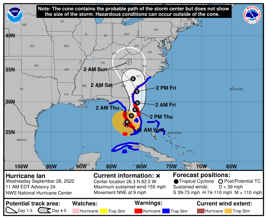
Category 4 hurricane
Maximum sustained winds: 155 mph
Movement: NNE at 9 mph
Location: 26.3 N 82.5 W, about 45 miles WNW of Naples, about 50 miles SSW of Punta Gorda
10:50 a.m. | Jacksonville Humane Society seeks help from community

The Jacksonville Humane Society is seeking families who can temporarily care for dogs and cats until Hurricane Ian passes by, at least until Monday.
The animals are currently living in the shelter, but officials would like to see them in homes for at least a while.
“There’s no better way to ride out a scary storm than with a loving family,” said Denise Deisler, JHS CEO. “We are grateful that we can always count on the compassion of the Jacksonville community.”
Stop by the humane society at 8464 Beach Blvd. between noon and 7 p.m. Wednesday if you're interested in helping. If additional help is needed, the shelter will be open from noon to 4 p.m. Thursday.
10:15 a.m. | City to open additional evacuation shelters
Following Tuesday's announcement that an evacuation shelter would open at the Legends Center, Jacksonville Mayor Lenny Curry announced the opening of additional shelters, all scheduled to open at 5 p.m. today:
Lavilla Middle School, 501 N. Davis St.
Landmark Middle School, 101 Kernan Blvd.
Atlantic Coast High School, 9735 RG Skinner Parkway
The Legends Center is located at 5130 Soutel Drive.
If you choose to go to an evacuation center, the city recommends you bring the following:
Air mattress, blankets, pillows or other bedding
Food, water and medication
Important papers
Games, toys and books
Additional safety, hygiene and comfort items
Emergency supply kit
The mayor reiterated his earlier statement that at this time, he does not anticipate ordering mandatory evacuations. But he did encourage residents living in Zones A and B and in other low-lying areas to consider making plans to evacuate.
“I am not calling for mandatory evacuations. But if you know your home and property are at risk, please consider leaving, even if for just a short time or only the duration of the storm,” Curry said during a 10 a.m. news conference.
10 a.m. | Rain, wind move into Atlantic Beach
8:45 a.m. | Nassau County issues evacuation order
Nassau County has issued an evacuation order for zones A and D. View the Nassau evacuation map here. The order was issued at 8 a.m. Wednesday.
Evacuation Order Issued
As of 8:00 a.m. this morning, Nassau County has issued an Evacuation Order for Evacuation Zones A and D. pic.twitter.com/DqKKsORlI3— NassauEM (@NassauEM) September 28, 2022
8:40 a.m. | No mandatory evacuations in Jacksonville at this time
Mayor Lenny Curry tweeted this morning that he wasn't issuing mandatory evacuations at this time.
He plans to update the community about city preparations at 10 a.m. The Times-Union will provide coverage of that briefing.
Based on the current trajectory of Hurricane Ian , I will NOT BE ISSUING MANDATORY EVACUATIONS at this time.Please join me for an important briefing on your local news stations at 10 AM this morning for additional information and recommendations for citizens throughout @CityofJax
— Lenny Curry (@lennycurry) September 28, 2022
Curry had asked people in Zone A to prepare to evacuate today, but the track for Ian continues to move further off the coast.
In St. Johns County, evacuations of coastal areas, including the city of St. Augustine are underway. View the evacuation zone map or use this tool to search by address.
In Clay County, evacuation orders were issued Tuesday for residents living in zones A, B, C and the Black Creek North and South Prong zones, as well as those who live in mobile or manufactured homes. View the evacuation zone map.
8 a.m. | Updated tracking map, forecast for Hurricane Ian
Here's the latest update on Hurricane Ian from the National Hurricane Center.

Category 4 hurricane
Maximum sustained winds: 155 mph
Movement: NNE at 10 mph
Location: 26.0 N 82.7 W, about 55 miles W of Naples, about 60 miles SW of Punta Gorda
6:15 a.m. | Jacksonville first responders head to Orlando
Members of the Jacksonville Fire and Rescue Department are heading to Orlando to be nearby to provide aid after Ian.
The city is sending about 30 people, including five from the Jacksonville Sheriff's Office, as a state Emergency Road Access Team.
We just sent 30 people including 5 @JSOPIO to deploy to Orlando as a state ERAT (Emergency Road Access Team)…this is the first deployment of its kind and we appreciate the support from @lennycurry @CityofJax and other city officials…. Be Safe all! pic.twitter.com/xURmDFL11M
— THEJFRD (@THEJFRD) September 27, 2022
Mayor Lenny Curry tweeted, in part: "Thank you for your continued courage and sacrifice for our fellow Floridians."
6:05 a.m. | Community supports Ken Knight Drive residents
After Hurricane Irma hit in 2017, residents of Ken Knight Drive in Washington Heights said they felt forgotten as they waited for city help.
It was the community, including some churches and nonprofits, back then that first came to the residents' aid
This week, it's once again the community that's rallying around the residents.
10 citizens, volunteers, people who love their neighbors filled 200 sand bags to support a community that asked for help. Ken Knight Dr. residents know better than most the long impacts of flooding. COJ doing nothing, have done nothing since Irma despite getting millions $$. 1/2 pic.twitter.com/nb7buxM1gv
— Hope (@hmcmath) September 27, 2022
Two years after Irma, the city planned a buyout program for homes on Ken Knight Drive, but it's not immediately clear the status of that program.
But in tweets this week, McMath said much of the promised help from the city never came.
More volunteers are planning to help from 8 a.m. to 10 a.m. today at 11761 N. Main St to bag sand and deliver it to Ken Knight Drive.
5:55 a.m. | JEA pauses utility disconnections
JEA customers who face disconnection of their utility service will get a grace period through Oct. 9 and the city of Jacksonville will use a fresh infusion of money in its 2022-23 budget for emergency relief that can help residents keep the lights on.
Chief Administrative Officer Brian Hughes said the budget will "recharge the coffers" of the city's social service division that responds to requests for help paying utility bills.
He said if the demand for assistance causes the amount of city dollars to run out, city administrators will "come back here immediately" with a request for more funding. He said the Curry administration also will track whether relief payments are going out too slowly and adjust the application process if needed to "help as many people as possible."
Hurricane Ian: JEA pauses utility disconnections and city replenishes emergency relief program
5:45 a.m. | Duval Schools closed through Friday
A reminder: Duval Schools are closed today as Hurricane Ian continues on a path toward Northeast Florida. Schools in the district were set to release students early today before fully closing Thursday and Friday, but changed course after Jacksonville Mayor Lenny Curry said evacuations in some areas of the county may be necessary as early as today.
All extracurricular activities, including athletic practices and games, will be canceled until Monday.
5:15 a.m. | Evacuations in select areas in Northeast Florida possible or underway
Duval County residents who live in Zone A should prepare for a possible evacuation as early as this morning, Jacksonville Mayor Lenny Curry said late Tuesday. If you're not sure whether your home is in Zone A, check the county's evacuation zone map. Or you can use this tool to search by address.
In St. Johns County, evacuations of coastal areas, including the city of St. Augustine are set to begin at 6 a.m. Affected evacuation zones include A, B and F, south of County Road 214. View the evacuation zone map or use this tool to search by address.
In Clay County, evacuation orders were issued Tuesday for residents living in zones A, B, C and the Black Creek North and South Prong zones, as well as those who live in mobile or manufactured homes. View the evacuation zone map.
5:00 a.m. | Updated tracking map, forecast for Hurricane Ian
Here's the latest update on Hurricane Ian from the National Hurricane Center.


Read live updates from Tuesday, Sept 27 here.
This article originally appeared on Florida Times-Union: Hurricane Ian Jacksonville: What you need to know about impact, path

