Hurricane Ian: Marion schools closed Wednesday and Thursday; shelters, sandbags available
Marion County Public Schools will be closed Wednesday and Thursday so emergency officials can open designated school shelters both for local citizens and for Floridians fleeing from the west coast as Hurricane Ian approaches.
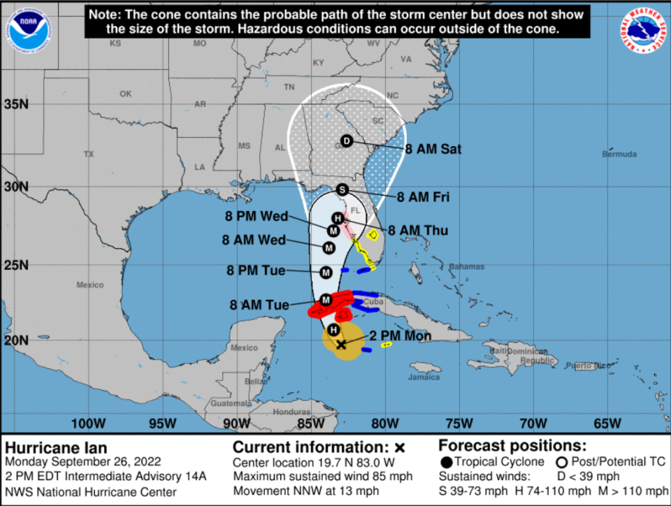
At 5 p.m. Monday, Marion County was placed under a tropical storm watch. The predicted path has Ian making landfall just north of Tampa, and south of Cedar Key, and skirting Marion's western county line.
The Marion County Commission declared a state of emergency at 2 p.m. Monday during a special meeting to address Hurricane Ian, which is strengthening in the Caribbean Sea and is expected to cross Cuba and head north toward Florida’s west coast, near Tampa.
The latest on Ian: Ian reaches hurricane strength, could become 'catastrophic' Category 4 storm targeting Florida
Be prepared: 'Mother Nature ultimately decides' where a hurricane will go, and Marion County should prepare
Ian photos: Ian projected to become major hurricane soon. Where it will go remains uncertain
The emergency declaration states it “is in the best interests of the citizens of Marion County to activate emergency management preparations in advance of Hurricane Ian in order to minimize the hazards and damage that may be created by such storm.”
Marion County officials addressed the commission, stating that the early stages of their emergency plan is up and running.
Tracy Straub, assistant county administrator, noted that after wind speeds hit about 30 mph most road-clearing teams and other staff will be grounded until it is safe for them to be back on the streets and highways.
During the storm, and immediately after Ian passes, officials urge residents not to leave their homes, especially if power lines are down and trees are in roadways. The news comes as it remains uncertain where Ian will make landfall.
“I think it's just extremely important that we reiterate to the public, as we always do, if you don't need to be out on the road after the storm, do not go out,” Commissioner Kathy Bryant said. “That's the safest bet for everyone and it could help us to save lives.”
The timing of when Ian may threaten the Tampa area, and subsequently Marion County, is still evolving. Computer models used by the National Hurricane Center show landfall will be anywhere from Panama City to Sarasota.
Where will Hurricane Ian make landfall in Florida?
The National Hurricane Center uses the middle of all those model runs, which places Ian’s landfall near south of Cedar Key at about 2 p.m. Thursday as Category 1 hurricane and then skirting the western Marion County line as it heads north.
Ian is expected to be packing 140 mph wind as it approaches Tampa.
Ian may weaken after skirting north of Tampa. Officials say high-level wind sheer may lop off the high cloud tops, or what is called wind sheer. Since warm water is needed for hurricanes to strengthen, experts also believe the cooler water north of Tampa will also help deescalate the storm.
But that does not mean that this part of Florida would be out of the woods if that scenario pans out. Ian could dump as much as a foot of rain on Marion County and areas west of Ocala could get 45 mph wind gusts as Ian heads north.
The National Hurricane Center states in its discussion that Ian continues to move northwest in the Caribbean Sea toward Cuba at 13 mph. The statement stated: "A turn toward the north-northwest and north is expected during the next day or so as the hurricane moves around the western extent of a mid-level ridge."

"Then an upper-level trough over the eastern U.S. should cause Ian to turn more north-northeastward through Thursday," the statement states. "This track brings the center of Ian close to the west-central coast of Florida during the middle of the week."
The main issue is that there is an even greater concern that "the slower forward motion that is forecast during this period, as the upper trough passes north and east of Ian and the steering currents weaken."
"This would likely prolong the storm surge, wind, and rainfall impacts along the affected portions of the west coast of Florida, although the roughly shore-parallel track still makes it difficult to pinpoint exactly what locations will experience the most severe impacts."
Why are school being closed before Ian's landfall is pinpointed?
School Board Chairman Eric Cummings said after the school closings were announced that emergency officials believe Marion could begin feeling the impacts of Ian as early as Wednesday afternoon.

He said the decision to close the school district on Wednesday was just in case wind speed tops 35 mph and pose a threat to high-profile buses on roadways. Also, Marion County Emergency Management needs to set up the shelters well before the storm arrives.
“We do not want to be put in a situation where we are transporting children during high wind,” said Cummings, adding buses cannot be used when wind speeds reach above tropical storm force of 35 mph.
Kevin Christian, the school district spokesman, stated in a press release that Tuesday will be a regular school day. However, West Port High School will switch to virtual learning so the school can transition into a special needs shelter. All extra-curricular activities district-wide are also canceled Tuesday.
Decisions regarding Friday will be made later this week and shared via www.marionschools.net, Skylert messaging, social media channels and local media.
What will it mean for Marion County if Ian makes landfall south of Cedar Key?
Hurricane Ian could make landfall near Cedar Key early Friday as a Category 1 storm and that could soak Marion County with 8 inches of rain, up to a foot in some areas, and produce tropical storm-force wind west of Ocala.
Under this track, Marion County should start seeing rain bands and wind gusts of 30 mph Tuesday evening. Wednesday the wind and rain will pick up and the worst of the wind and rain will hit Thursday after midnight through Friday morning, with sustained wind of up to 60 mph and gusts up to 70 mph in west Marion County.
That's all according to the latest update from the National Hurricane Center, which updates the status of hurricanes every three hours. One thing is certain: Ian will head toward Florida. But where it makes landfall could shift many times in the coming days.
Dozens of computer models seem to be in two different camps when it comes to where in Florida the storm could make landfall:
One group of models, including the GFS, predicts a landfall in the Florida Panhandle, between Panama City and the Bid Bend just south of Tallahassee.
The other group, including the Euro model, predicts a landfall near Tampa. After landfall, some models show it crossing Florida and into the Atlantic Ocean, and others show it staying inland as it heads north.
The hurricane center's written discussion about Ian shows that a specific path is still uncertain.
"It should again be stressed that there is still significant uncertainty in the track of Ian, especially in the 3-5 day time frame, and users should not focus on the details of the track forecast at longer time ranges," the discussion noted.
Preston Bowling, Marion County's emergency management director, told the county commission Monday that "you know we prepared for every option that was going to be thrown our way."
— Contact Joe Callahan at (352) 897-0307or at joe.callahan@starbanner.com. Follow him on Twitter @JoeOcalaNews.
Hurricane Ian information
Marion County Public Schools and shelters
Marion County Public Schools will close Wednesday and Thursday. West Port High will open Tuesday at 5 p.m. as a special-needs shelter. The following schools will open at noon Wednesday as additional shelters:
Belleview Middle (10500 SE 36th Ave., Belleview)
Dunnellon High (10055 SW 180 Avenue Road, Dunnellon)
Fort McCoy School (16160 NE County Road 315, Fort McCoy)
Hammett Bowen Jr. Elementary (4397 SW 95th St., Ocala)
North Marion Middle (2085 W. County Road 329, Citra)
Vanguard High (pet friendly; 7 NW 28th St., Ocala)
For more information on sheltering, call the Marion County Citizens Information Hotline at (352) 369-7500.
Sandbag locations
The Marion County Emergency Management Operations Center is currently monitoring Hurricane Ian and has announced nine sandbag locations within Marion County.
These locations will be operational until 7 p.m. Monday and will reopen Tuesday from 8 a.m.-7 p.m. These sandbag locations are self-serve; limit of 10 bags per vehicle.
Dunnellon City Complex: 11808 N. Ohio St,, Dunnellon
Wrigley Field: 405 East County Road 316, Citra
East Marion Sports Complex: 14445 NE 14th St. Road, Silver Springs
Belleview Sports Complex: 6501 SE 107th St., Belleview
Jervey Gantt Park: 2200 SE 36th Ave., Ocala
Tuscawilla Park (Reilly Arts Center): 800 NE Sanchez Ave., Ocala
Hampton Center: 1501 W. Silver Springs Blvd., Ocala
Martel Recycling Center: 296 SW 67th Ave., Ocala
Marion Oaks: 294 Marion Oaks Lane (behind the Community Center), Ocala
For more information
The Marion County Emergency Management Citizen’s information line will be available until 8 p.m. Monday and will reopen at 7 a.m. on Tuesday. Call (352) 369-7500 for any questions about Hurricane Ian. This is for non-emergency inquiries only. Call 911 for emergencies.
Citizens can also go to www.marionso.com or visit the Marion County Sheriff’s Office Facebook page for updates on the storm.
In addition, emergency management officials are encouraging all Marion County citizens to sign up for the emergency notification system, Alert Marion. Sign up for text message alerts, emails, and phone calls for severe weather at www.alertmarion.com.
This article originally appeared on Ocala Star-Banner: Marion County, Florida eyes next steps as Hurricane Ian approaches

