Hurricane Ian nears Category 5 status. When will we see remnants?
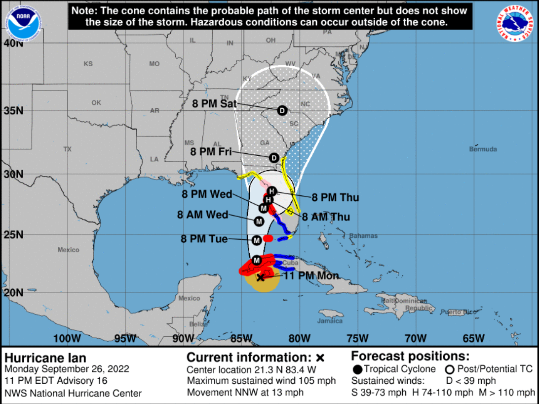
STAUNTON — The coast off of Florida was slammed by Hurricane Ian Wednesday morning and the storm will be moving more inland by the afternoon. The storm was nearing a historic Category 5, according to the Hurricane Center. AccuWeather said landfall of the storm is projected to occur south of Venice and north of Fort Myers, Florida, between noon and 3 p.m.
According to PowerOutage.Us, well above 100,000 homes were without power. Conditions are expected to get worse through Florida as the storm makes landfall, AccuWeather said. There is also a significant tornado threat to southern Florida, AccuWeather said.
Following the projected path of the storm, where it stands now, it shows it hitting the coast of Georgia by Friday and sweeping up through the Carolinas reaching the intersection of North Carolina, Tennessee, Kentucky and Virginia by Sunday.
For now, the path of the storm doesn't show any direct hits to the Shenandoah Valley.
More:Hurricane Ian nears historic Category 5 status as it nears Florida landfall: Live updates
National Weather Service Meteorologist Chesnea Skeen said it's unclear what state the storm will be in once it reaches us — if at all. It might not be a hurricane, tropical storm or depression with the remnants of Hurricane Ian at that point, Skeen said.
"Impacts are a little up in the air, dependent on the track, there's some uncertainty," Skeen said. "Right now, moderate to heavy rainfall from the remnants of Ian should land Saturday. We've been pretty dry lately, the rainfall will be pretty steady over several days."
Flooding, if any, would be isolated, Skeen said. Moderate to heavy rainfall will occur Saturday through Monday.
National Weather Service forecast
Wednesday
Sunny, with a high near 65. Light and variable wind becoming north around 6 mph in the afternoon.
Wednesday night
Partly cloudy, with a low around 45. North wind 3 to 6 mph.
Thursday
Mostly sunny, with a high near 66. Northeast wind 5 to 10 mph, with gusts as high as 20 mph.
Thursday night
Partly cloudy, with a low around 45. North wind 5 to 7 mph.
Friday
A slight chance of rain after 3 p.m. Mostly cloudy, with a high near 63. North wind 7 to 9 mph. Chance of precipitation is 20%.
Friday night
Rain likely, mainly after 9 p.m. Cloudy, with a low around 50. Chance of precipitation is 70%.
Saturday
Rain. High near 58. Chance of precipitation is 80%.
Saturday night
Rain. Low around 52. Chance of precipitation is 80%.
Sunday
Rain likely. Cloudy, with a high near 60. Chance of precipitation is 70%.
Sunday night
Rain likely. Cloudy, with a low around 51. Chance of precipitation is 70%.
Monday
Rain likely. Cloudy, with a high near 59. Chance of precipitation is 60%.
Monday night
A chance of rain. Mostly cloudy, with a low around 48. Chance of precipitation is 50%.
Tuesday
A chance of showers. Mostly cloudy, with a high near 62. Chance of precipitation is 40%.
More:'Mistake in judgment': Staunton teacher apologizes for email critical of school board candidate
More:Beam Internet services through Shentel to be discontinued in Augusta County
More:Craigsville mobile home park residents lose water access
Laura Peters is the trending topics reporter at The News Leader. Have a news tip on local trends or businesses? Or a good feature? You can reach reporter Laura Peters (she/her) at lpeters@newsleader.com. Follow her @peterslaura. Subscribe to The News Leader at newsleader.com.
This article originally appeared on Staunton News Leader: Hurricane Ian nears Category 5 status. When will we see remnants?

