Hurricane Ian: What Palm Beach County residents need to know now
The Palm Beach Post has made this article free of charge for all readers in the interest of public safety. Consider supporting the Post with a digital subscription.
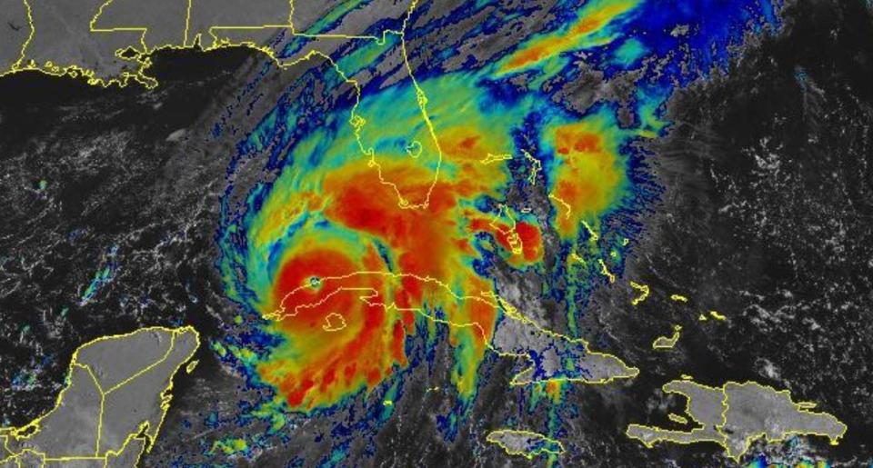
As Hurricane Ian barrels toward the Tampa area as a major hurricane, Palm Beach County will still feel its effects.
Here's what you need to know now.
We're now under a tropical storm warning instead of a watch. What's the difference?
A tropical storm watch is issued when a tropical cyclone containing winds of 39 to 73 mph or higher poses a possible threat, generally within 48 hours. These winds may be accompanied by storm surge, coastal flooding, and/or river flooding.
The watch does not mean that tropical storm conditions will occur. It only means that these conditions are possible.
LIVE COVERAGE: Hurricane Ian live updates: Schools closed Wednesday, Tropical storm warning for Palm Beach County
A tropical storm warning is issued when sustained winds of 39 to 73 mph or higher associated with a tropical cyclone are expected in 36 hours or less. These winds may be accompanied by storm surge, coastal flooding, and/or river flooding.
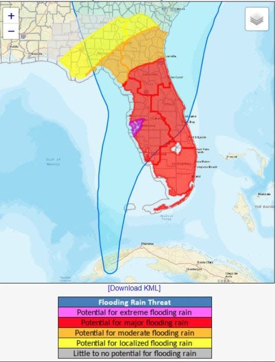
When will we get the rains from Ian?
Hurricane Ian's outer bands began reaching Palm Beach County overnight and rain will be heaviest Tuesday into Wednesday. Up to 8 inches of rain is expected in isolated areas of Palm Beach County and a flood watch is in effect for all of South Florida through Thursday.
Fall's king tides are also a concern as rainfall may have trouble draining and southeast- to-east winds push water into inlets. High tide times at the Lake Worth Pier on Tuesday are 9:38 a.m. and 9:49 p.m. and 10:22 a.m. and 10:30 p.m. on Wednesday.
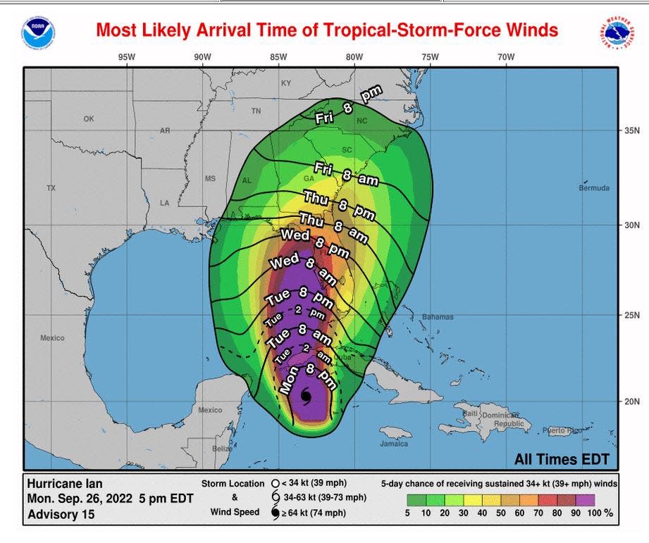
Will we feel tropical storm-force winds? If so, when?
Chances have increased that Palm Beach County will feel tropical storm-force winds of 39 mph or higher as the track cone of Hurricane Ian has shifted east. The most likely arrival time of tropical-storm-force winds is Wednesday morning through afternoon.
Meteorologists believe tropical storm-force gusts are most likely, but said some sustained winds of 39 mph-plus are possible.
It is dangerous to drive in winds above 39 mph.
Will we see flooding?
Flooding is one of the biggest concerns with Hurricane Ian. Low-lying areas in Palm Beach County and those that typically flood are expected to see the highest waters, especially along the Intracoastal Waterway.
There is a 1-foot storm surge expected along the east coast, but that is mainly because of the southeast winds and higher-than-normal astronomical tides.
Are Palm Beach County schools open Tuesday?
Palm Beach County schools are open Tuesday but extracurricular activities have been canceled. Schools will closed Wednesday. Follow @pbcsd on Twitter for updates. For full story, go here.
Are Broward County schools closing?
According to the Florida Department of Education website, Broward County Schools will be closed Wednesday and Thursday. Also closed Wednesday and Thursday are Miami-Dade, Martin, St. Lucie and Indian River counties. For the full state list, go here.
Is Palm Beach airport open? Fort Lauderdale?
Palm Beach International Airport and Fort Lauderdale-Hollywood International Airport are open but please continue to check their social media sites and websites for updates on delays or flight cancellations.
Twitter: PBIA (@flyPBI); Fort Lauderdale (@fllFlyer)
Facebook: PBIA, Fort Lauderdale
Websites: PBIA, Fort Lauderdale
This article originally appeared on Palm Beach Post: Hurricane Ian: What Palm Beach County residents need to know now

