Hurricane Idalia update for Aug. 29: When storm makes landfall, how it will impact NC
North Carolina is under a state of emergency in anticipation of two hurricanes that will brush the state this week.
Hurricanes Franklin and Idalia are expected to bring the potential for rip currents along the coast, flash flooding in Southeastern North Carolina and heavy rain as far inland as I-95 midweek.
Franklin timeline: Heavy surf, rip currents at the coast
Franklin — which the National Hurricane Center predicts will bring life-threatening surf and rip currents along the southeastern coast — is not expected to make landfall.
▪ A Tropical Storm Watch is in effect in Bermuda, meaning tropical storm conditions are possible. Frankin is expected to make its closest approach to the island on Wednesday morning.
▪ It’s forecasted as a Category 4, the strongest of the Atlantic’s 2023 hurricane season, though the eye of the storm should stay far out at sea.
Monday morning imagery of #Franklin and #Idalia
It's not a stretch to think they could both be major hurricanes at the same time (maybe Wednesday). Lets hope not. Also both these storms could impact #Bermuda in some fashion at different times going forward. pic.twitter.com/pBSjerFemN— Jim Cantore (@JimCantore) August 28, 2023
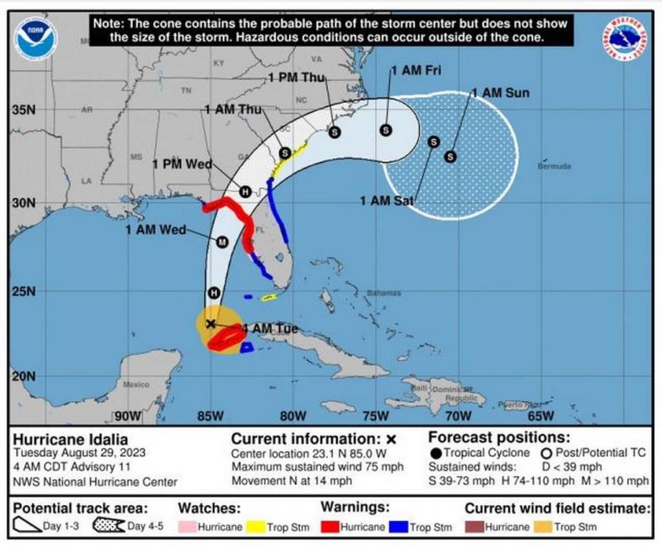
Idalia timeline: Making landfall in the U.S. Wednesday
Idalia — which National Hurricane Center meteorologists pronounce ee-DAHL-yuh — strengthened to a hurricane early Tuesday in the Gulf of Mexico. It’s expected to bring life-threatening storm surge and high winds to Florida’s Gulf Coast after pelting Cuba.
▪ Strong winds will spread across nothern Florida and southern Georgia, and NOAA advises residents to be prepared for long-duration power outages.
▪ Storm surge is expected to have “catastrophic impacts,” with inundation 10 to 15 feet above ground level and destructive waves in Florida.
▪ By the time it makes landfall in that area on Wednesday, forecasters say the storm could be a Category 3 hurricane with peak winds of 129 mph.
8/29 11am Hurricane #Idalia update:
Maximum sustained winds of 85 mph, moving north at 14 mph
Catastrophic storm surge of 10-15 feet now expected north of Yankeetown, FL
️ Destructive winds and heavy rainfall will impact much of the west coast of FL#FLwx pic.twitter.com/FYJ93gwvwF— NWS Tampa Bay (@NWSTampaBay) August 29, 2023
Hurricane Idalia’s impact on North Carolina
NOAA said the storm will move northeast, bringing tropical storm conditions to North Carolina Wednesday into Thursday, as well as South Carolina and Georgia.
Heavy rains and gusty winds will impact central North Carolina, with the worst conditions to the south and east of Raleigh.
▪ Idalia could bring 4 to 6 inches of rain as far inland as I-95.
▪ From I-95 to just east of Wake County, forecasters are calling for an inch to 4 inches of rain. From Wake County to the mountains rainfall amounts vary from none to as much as 4 inches.
▪ Midweek, the Raleigh area is at a marginal risk (at least 5%) of flash flooding, while the southern coast of the state near Wilmington is at moderate risk (at least 40%). The majority of the state is at a slight risk (at least 15%).
Heavy rain from Hurricane Idalia is expected across portions of the west coast of FL, the FL Panhandle, and southern Georgia today into Wednesday, spreading into portions of the eastern Carolinas Wednesday into Thursday. Some resulting flash floods could be locally significant. pic.twitter.com/nQOW982TPO
— NWS Weather Prediction Center (@NWSWPC) August 29, 2023
North Carolina: State of emergency
The state of emergency, declared Monday morning, will:
Activate the state’s emergency operations plan
Waive transportation rules to help the transport of fuel and critical supplies and services
Help first responders and assist the agriculture industry to prepare in advance for inclement weather
Protect consumers from price gouging
“We are continuing to monitor Idalia’s course and its potential impacts on our state and it’s critical to make sure we are fully prepared,” Cooper said in a press release.
“It is important for North Carolinians to gather emergency kits and prepare for the storm before it’s too late. We also want to make sure our farmers are able to protect their crops.”
How to prepare for Hurricanes Idalia, Franklin in NC
Cooper and state officials advise taking the following precautions to ensure everyone’s safety:
Have multiple ways to receive emergency information, including watches and warnings. Make sure emergency alerts are enabled on a cell phone and download a weather app.
Have an emergency plan. Know where to go if there’s a need to evacuate. Make a plan to stay with family, friends or at a hotel. Public shelters should be a last resort.
Gather some emergency supplies or refresh an emergency kit. Visit ReadyNC.gov for info on how to build an emergency kit.
If people live near or are visiting the coast, be aware if you are located in a coastal evacuation zone. Visit KnowYourZone.nc.gov to see if you are located in a pre-determined evacuation zone. Learn your zone and listen for it if evacuations are ordered by local governments.
Never drive through flooded roadways. Turn around, don’t drown.
For more, visit governor.nc.gov.
How much rain will Raleigh get from Idalia?
The area could see gusty winds and heavy rainfall Wednesday into Thursday, NWS Raleigh forecasted.
This is especially possible across the southern Coastal Plain and Sandhills.
The highest winds are expected along and east of I-95. This could result in scattered downed trees and power outages.
What about the weather on Labor Day Weekend?
Conditions should improve on Friday, with clear skies and temperatures in the 80s, then dropping in the 60s overnight.
Labor Day is expected to be sunny with a high near 91.
3 named storms have formed in the Atlantic and 2 more are brewing. What to expect in NC.
Will NC get a fall hurricane this year? Here’s when Farmers’ Almanac says to be ready

