Update for Hurricane Idalia in North Carolina: What to expect on Wednesday
Hurricane Idalia made landfall Wednesday morning in Florida, bringing a dangerous storm surge and 130 mph winds to the state’s Big Bend and starting on its northeasterly path that will bring tropical storm conditions all the way to North Carolina.
The National Weather Service Raleigh issued a hazardous weather outlook for central North Carolina, forecasting strong winds and heavy rain Wednesday and Thursday.
Here’s what to expect from the storm today. We will update this story as NOAA adds new information.
7:45 AM EDT update: Extremely dangerous Category 3 Hurricane #Idalia makes landfall in the Florida Big Bend. Maximum sustained winds were estimated to be 125 mph. Catastrophic storm surge and damaging winds ongoing. pic.twitter.com/umMdj8dD5d
— National Hurricane Center (@NHC_Atlantic) August 30, 2023
Wednesday’s forecast in NC from Hurricane Idalia
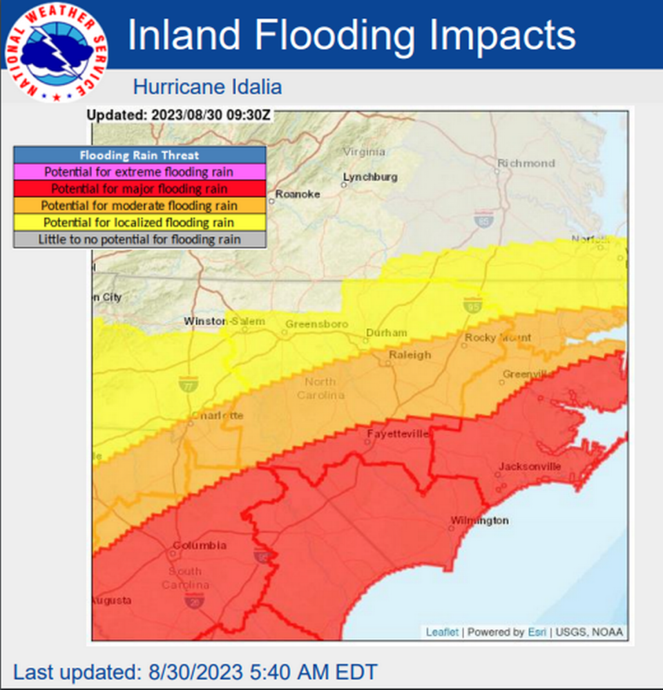
▪ Rain in the Triangle: The Raleigh area will get 1-2 inches of rain from Wednesday afternoon to Thursday evening.
▪ Rain across NC: The heaviest amounts are expected in the Sandhills region, covering the surrounding Fayetteville area and Cumberland County, said meteorologist Andrew Kren. Total rainfall amounts of 2-5 inches through Thursday are expected south and east of Raleigh with localized amounts of more than 6 inches.
Flash flooding and river flooding are possible. Urban flooding is possible especially in Wilmington and Fayetteville, meteorologists say. Light rain began on the southern coast of North Carolina after 2 p.m. as the first bands of the storm arrived.
Parts of the Piedmont could get up to 2 inches of rain from the storm.
▪ Flooding: Possible across southern and eastern portions of North Carolina. A flood watch is in effect from 2 p.m. Wednesday through Thursday evening.
Excessive runoff might result in flooded rivers, creeks, streams and other flood-prone locations.
Wednesday afternoon, Cumberland County announced it would open two emergency shelters for residents who need a safe place to go during the storm. Smith Recreation Center at 1520 Slater Avenue and Kiwanis Recreation Center at 352 Devers Street will open at 7 p.m. today.
*A storm-surge watch is in effect from Beaufort Inlet to Ocracoke Inlet, and in the Neuse and Pamlico rivers. Water could reach up to 4 feet above ground level in some areas under the right conditions.
▪ Rough seas/Rip currents: The marine forecast for areas North Carolina affected by the storm calls for 4- to 6-foot seas Wednesday afternoon, 7- to 10-foot seas after midnight and 8- to 11-foot seas on Thursday. Increased wave action raises the risk of dangerous rip currents.
Cape Lookout National Seashore will temporarily close all public access facilities on Thursday due to the risk of rip currents and of flooded roads leading to the area.
▪ Wind: Gusty winds of 30 to 40 mph. Isolated gusts to 45 mph.
There is a 5-10% chance of tropical storm force winds across southeastern portions of central North Carolina. The earliest reasonable time of arrival is early Wednesday evening.
▪ Tornados can be spawned by hurricanes and often cause more injury and damage than the hurricane itself. A tornado watch is in effect from Hilton Head, S.C. to Surf City until 10 p.m. Wednesday. In North Carolina, the watch covers Brunswick, Columbus, New Hanover and Pender counties.
King tide, supermoon (Blue Moon) could worsen flooding in NC
Flooding at the coast can be made even worse with Wednesday night’s supermoon, which is triggering a king tide.
Supermoon: This occurs when the moon’s orbit is closest to Earth during a full moon cycle. Also known as a Blue Moon.
King tide: These are the highest of the high tides. They typically occur during a full or new moon and when the Earth is at its perigee — the closest location to Earth during its monthly orbit. The closer the moon is to Earth, the higher the tide.
People who live near the beach can sometimes have flooding issues from the king tides alone, even without a tropical cyclone.
“Wrightsville Beach is expecting its high tide at 7:55 a.m. Thursday morning, for example, and Beaufort’s is at 8:32 a.m., coinciding with the time impacts will be ongoing from Idalia. This could exacerbate already high water levels, particularly in those most vulnerable areas,” said Ryan Ellis, science and operations officer at NWS’ Morehead City office.
If you need shelter from the storm
Wednesday afternoon, Cumberland County announced it would open two emergency shelters for residents who need a safe place to go during the storm. Smith Recreation Center at 1520 Slater Avenue and Kiwanis Recreation Center at 352 Devers Street will open at 7 p.m. today.
The latest on what Idalia is doing
After making landfall as a Category 3 hurricane, Idalia lost some strength through the day, with wind speeds dropping to 70 mph before 5 p.m., degrading to a tropical storm. Meteorologists say the center of the storm should track northeasterly across Florida on its way to the Atlantic.
NOAA says the storm should move offshore on Thursday and track to the east-southeast into the Atlantic Friday.
Late Wednesday morning, the southeast U.S. coast was under a tropical storm warning from Sebastian Inlet, Fla., to the Virginia border, with a section of Florida still under a hurricane warning.
Here's the latest on impacts from Hurricane #Idalia in central #NCwx. 2-5" of rain (locally 5-7") is expected to the south & east of Raleigh, which may cause flash flooding. Wind gusts of 30-45 mph may also cause scattered downed trees & power outages, especially in the far SE. pic.twitter.com/PE6ahK0v8K
— NWS Raleigh (@NWSRaleigh) August 30, 2023

