Idalia downgraded to Tropical Storm: Still set to impact Savannah area
Hurricane Idalia, which was downgraded to a Tropical Storm around 5:45 p.m. Wednesday, is set to bring heavy rain and strong winds to south and coastal Georgia, including the Savannah area.
Gov. Brian Kemp declared a state of emergency on Tuesday and is set to expire at 11:59 p.m. on Friday.
"We are taking every precaution ahead of Hurricane Idalia's landfall tomorrow, and I am taking this additional executive action to ensure state assets are ready to respond" said Governor Brian Kemp in a release. "Georgians in the expected impact area can and should take necessary steps to ensure their safety and that of their families. We are well positioned to respond to whatever Idalia may bring."
Check below for the latest updates. This story will be updated regularly by Savannah Morning News staff.
Latest NOAA advisory: Tropical Storm Idalia moves into South Carolina 9 p.m. update
A tropical storm warning is still in effect for Savannah with storm surge warnings from St. Catherine's Sound, Georgia, to South Santee River in South Carolina.
Savannah Morning News updates will resume Thursday morning after damage assessments. City of Savannah offices will remain closed through Thursday.
Downed trees and power lines: City of Tybee Island warns residents to stay inside 8 p.m. update
The City of Tybee Island posted on its Facebook page telling residents and visitors to stay inside unless absolutely necessary. There are downed trees and power lines around the island. City crews will be out at first light to assess and repair storm damage. City Hall will be closed again Thursday.
Storm approaching: Chatham Emergency Management Agency 5 p.m. update
Idalia was downgraded to a Tropical Storm around 5:45 p.m., and Georgia's north coast counties still remain ready for its upcoming impact. Chatham Emergency Management Agency (CEMA) stated in its 5 p.m. update that the area is under a Tropical Storm Warning and Storm Surge Warning; a Tornado Watch is in effect until 6 p.m., and a Flood Watch until 2 a.m.
As of 5:30 p.m., Idalia was a Tropical Storm with tropical storm force winds and higher gusts located 25 miles west of Chatham County moving in a northeasterly direction at 21 mph.
The greatest impacts are expected to occur in Chatham County between now and 9 p.m.
The agency said that the greatest impacts are still predicted to be rainfall, coastal flooding and rip currents. Areas prone to flooding are at risk, and with the additional kick from a king tide the tides at Fort Pulaski's tide monitor are predicted to be at 10.1 feet. The risk of severe weather, including tornadoes, still exists.
Bryan and Effingham schools closed Thursday | 3:35 p.m.
Both Bryan and Effingham schools announced Wednesday that they would be closed Thursday but will re-open Friday.
Weather.com radar projecting hurricane to move toward Augusta and Columbia, S.C. | 3:30 p.m.
As of mid-afternoon, the weather radar is showing that the worst of Hurricane Idalia will move through the state more toward Augusta and Columbia, S.C. rather than taking aim at the coast. However, more than 8,000 Georgia Power customers have been affected by the severe weather.
The core of the storm was over Swainsboro, 90 miles west of Savannah, as of 3:30 p.m.
The area around Claxton in Evans County is under a flash flood warning until 7 p.m.
City of Savannah to keep non-emergency offices closed Thursday | 3:05 p.m.
The City of Savannah stated government offices will remain closed through Thursday, August 31, due to inclement weather from Hurricane Idalia.
All critical workforce for the city and emergency essential services will continue responding at full capacity as weather permits. Those departments include public safety, sanitation, water and sewer, stormwater, park and tree, and traffic engineering, among others.
The following impacts to City services on Thursday, August 31 will be:
All non-emergency essential City government offices will be closed.
In-person payments at the Coastal Georgia Center for utility, tax, license, and other fees will be closed.
Recorder’s Court will be closed.
In-person services with the Office of Special Events, Film, and Tourism will be suspended.
Building closures, including all services within, will include City Hall, Civic Center, Community Centers, Cultural Arts Center, Floyd Adams City Services Complex, Savannah Municipal Services Annex and the Savannah Entrepreneurial Center.
Non-emergency public safety offices will be closed, to include police records.
According to the City of Savannah, sanitation collection services will resume on Thursday with a modified schedule. Wednesday's collection route will start on Thursday with subsequent collections resuming on Friday. Vegetative debris should be set out according to normal guidelines.
For questions about City services or to submit a service request, residents can call 311. Service requests can also be submitted online at Savannahga.gov/311request.
Tornado warning issued for Statesboro, Ga. | 2:25 p.m.
The NWS Charleston issued a tornado warning for Statesboro. This warning is active until 2:45 p.m.
According to the NWS, a tornado warning is when a tornado has been sighted or indicated by weather radar.
Tornado Warning including Statesboro GA until 2:45 PM EDT pic.twitter.com/peYOJ2QTrN
— NWS Charleston, SC (@NWSCharlestonSC) August 30, 2023
Wind gusts pick up in Savannah, Hurricane Idalia predicted path shifts | 2:15 p.m.
As Idalia moves across southeastern Georgia toward the South Carolina border, increased wind gusts and rainfall appeared in the Savannah area.
The latest path projection shows the eye wall, which was near Vidalia at 2:15 p.m., going north of Savannah rather than a direct hit.
Approximately 4,000 Georgia Power customers in the Savannah area are without power. More than 100,00 customers across the state are without power.
Bryan and Effingham counties prepare for storm
Bryan and Effingham County are preparing for the storm as it makes its way across south Georgia this afternoon. Bryan County recently issued a state of emergency.
Matthew Kent, public information officer for Bryan County, said the city is gassing up vehicles and the emergency operation center, where department heads and county leaders gather to make decisions, has been activated. Kent said it is imperative residents follow safety protocols throughout the entirety of the storm and to be mindful of floodwater.
“Public works is standing by for any damage that may be,” said Kent. “That may happen from high winds or flooding and they are clearing ditches to make sure they remain as clear as possible for water to flow through. For individuals, we always suggest having water and food for three days and for your pet as well. We encourage people not to drive across water because they don't know really know how deep it is and it doesn't take very much to make a car float.”
When the tornado struck Ellabell and Pembroke last year, the county had assistance from outside agencies. This time, they are on their own, making preparation for this storm even more meaningful.
“After [the tornado], we kind of went through to see what we could do better and to see what went well,” said Kent. “There are some things for emergencies that are consistent across the board as far as response goes. We will look at that tornado and see what we can draw from that.”
On the Effingham County Emergency Management Agency Facebook page, the organization is asking residents to take caution as the area is expected to receive 4-8 inches of rain. Residents living in the county should also expect power outages.
Savannah airport cancels flights for Hurricane Idalia | 12:30 p.m.
The Savannah/Hilton Head International Airport remains open, but all flights from 2 p.m. to tonight are canceled, according to Lori Lynah, Director of Marketing and Air Service Development.
The earliest flights on Thursday will either be delayed or canceled.
“We’re expecting resumption of service tomorrow, but I don’t have an exact time,” Lynah said in a phone call.
Part of I-75 closed in South Georgia | Noon
Power lines came down Wednesday at I-75 northbound near Loch Laurel Road about 10 miles south of Valdosta, according to Lowndes County's emergency service Facebook page.
Officials are routing northbound traffic off I-75 at Exit 5 and have set up a detour. They are currently waiting for conditions to improve/wind speed to drop so that the power company and Georgia Department of Transportation crews can safely respond. I-75 southbound is not affected.
What to know: Traffic disruptions on I-75 in south Georgia due to Hurricane Idalia
Savannah mayor, officials update on resources and potential curfew | 11:20 a.m.
During a press briefing, city leaders reiterated the need to shelter-in-place as Hurricane Idalia moves into Georgia.
“In short, the important thing is we are in a significant storm right now…and it’s going to get worse throughout the day,” City of Savannah Mayor Van Johnson said.
Johnson said he’s heard from the Federal Emergency Management Agency (FEMA) and the offices of Senators Jon Ossoff and Raphael Warnock, who offered their support to the city.
The city will open up a safety center, located at the Savannah Cultural Arts Center at 201 Montgomery Street, which will provide cots, water, and snacks as supplies are available. The center will be open from noon to 8 p.m., Johnson said. Pets are not permitted.
Johnson said the city and partners have set up a “street team,” which is “going out to places where people usually hang out,” ensuring the local homeless population has access to shelter.
City Manager Jay Melder noted the uptick in public safety operations, including two additional water rescue teams.
“Our number one priority is public safety. And that starts with our residents at home,” said Melder.
Audrey King, vice president of Georgia Power’s south region, said Georgia Power is prepared for the potential power outages that Idalia may cause. King said that Georgia Power has received assistance from Alabama Power and Mississippi Power.
“You may begin to see impacted areas as wind gusts increase fallen trees and downed power lines potentially,” said King.
Asked about the potential curfew, Mayor Johnson said, “Everything's on the table.”
“It depends on the conditions and depends on the recommendation from our public safety professionals. The key here is don't be out on the streets. If you don't have to be out in the streets, stay home.”
Hurricane Idalia now a Category 1, more than 20K without power in Valdosta area | 11 a.m.
Idalia was downgrade to a Category 1 storm, with max sustained winds of 90 mph, at 11 a.m.
The eye wall of the storm had been battering south Georgia, largely in the Valdosta area, for more than an hour. More than 20,000 Georgia Power customers were without power as of 11 a.m.
Roughly 4,000 customers in the Savannah area were without power, according to the Georgia Power Outage Map.
Tybee Island declares state of emergency, but no curfew will be implemented
City of Tybee Island Mayor Shirley Sessions posted on Facebook at 10 a.m., saying that a state of emergency for Tybee was being declared and there would be no curfew for residents but reminding them to stay off the streets and not drive through water.
Sessions added that there was hurricane watch in place until 3:00 p.m., a storm surge and tornado watch in place until 8:00 a.m. Thursday. Tybee is expected to feel the impacts as early as 10 a.m. to 2 p.m., with the most severe being from 5-10 p.m. The official high tide that's expected will be at 8:20 p.m., and 10.3 feet.
According to a NWS spokesperson, the center of the storm will pass over Tybee, with potential for sustained winds of 60-75 mph and wind gusts 70-80 mph, 3-4 inches of rain is expected with 3-5 feet of water.
Tornado warning issued for parts of Bryan County | 10:30 a.m.
The NWS Charleston issued a tornado warning for Richmond Hill, Keller and Burroughs in Bryan County. This warning is active until 11 a.m.
According to the NWS, a tornado warning is when a tornado has been sighted or indicated by weather radar.
Thousands without power in Valdosta area | 10:30 a.m.
According to the Georgia Power Outage Map, more than 10,000 customers in the Valdosta area are currently without power. The eye wall of the storm was moving through the area between 10-10:30 a.m., causing downed power lines and felled trees.
More than 1,000 people in the Brunswick area were also without power as of 10:30 a.m.
Georgia power outage map: See where the power is out as Hurricane Idalia nears
Tornado warning issued in parts of Chatham, Liberty counties | 10:10 a.m.
The NWS Charleston issued a tornado warning for Bloomingdale, Ellabell and Fleming in Chatham and Liberty counties. This warning is active until 10:30 a.m.
Bloomingdale is just west of the Savannah/Hilton Head International Airport, near the Tanger Outlets and Costco.
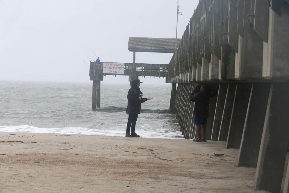
Tybee Island mostly empty ahead of Idalia's arrival | 10 a.m.
The beaches of Tybee Island were mostly empty Wednesday morning as residents brace for potential storm surge, which is predicted to be 2-4 feet. Intermittent heavy rains and winds came through the area as Idalia's bands moved in.
A handful of weather news teams — along with one solo fisherman — were seen along the Tybee Pier & Pavilion.
The eye wall of the storm was passing though south Georgia, near Valdosta, as of 10 a.m.
Hurricane Idalia downgraded to a Category 2 as it weakens over land | 9:30 a.m.
As Hurricane Idalia makes its way across north Florida and southeastern Georgia, the storm is now a category 2 hurricane, with maximum sustained winds of 110 mph.
The eye wall was crossing the Georgia-Florida border and nearing Valdosta as of 9:30 a.m. Wind gusts in the area could reach 80+ mph.
Savannah, Ga. seeing some rainfall, winds from Idalia outer bands | 8:30 a.m.
The Savannah area is beginning to see early effects of the Idalia outer bands, with light rain and mild winds in the area. Stronger winds are expected to arrive in the area between noon and 2 p.m.
Most streets in Savannah were relatively empty with little or no traffic.
The tide was extremely high with water reaching almost equal to River Street in some areas.
Georgia power outage map: See where the power is out as Hurricane Idalia nears
Traffic updates: Which roads in the Savannah area are closed? Live updates on Idalia's impact
Hurricane Idalia makes landfall in Keaton Beach, Fla. as category 3 storm | 7:52 a.m.
Idalia officially made landfall just before 8 a.m., bringing 125 mph winds to Keaton Beach and the surrounding coastal area. Much of north Florida, south and coastal Georgia were already seeing rain and some winds.
Idalia predicted to still be a hurricane when it arrives in Georgia
According to the latest model from the National Hurricane Center, Idalia will likely bring hurricane-level winds — approximately 74-110 mph — and rainfall to Georgia after passing through Florida.
Winds should begin to decrease in intensity as the storm moves into South Carolina and into the Atlantic Ocean.
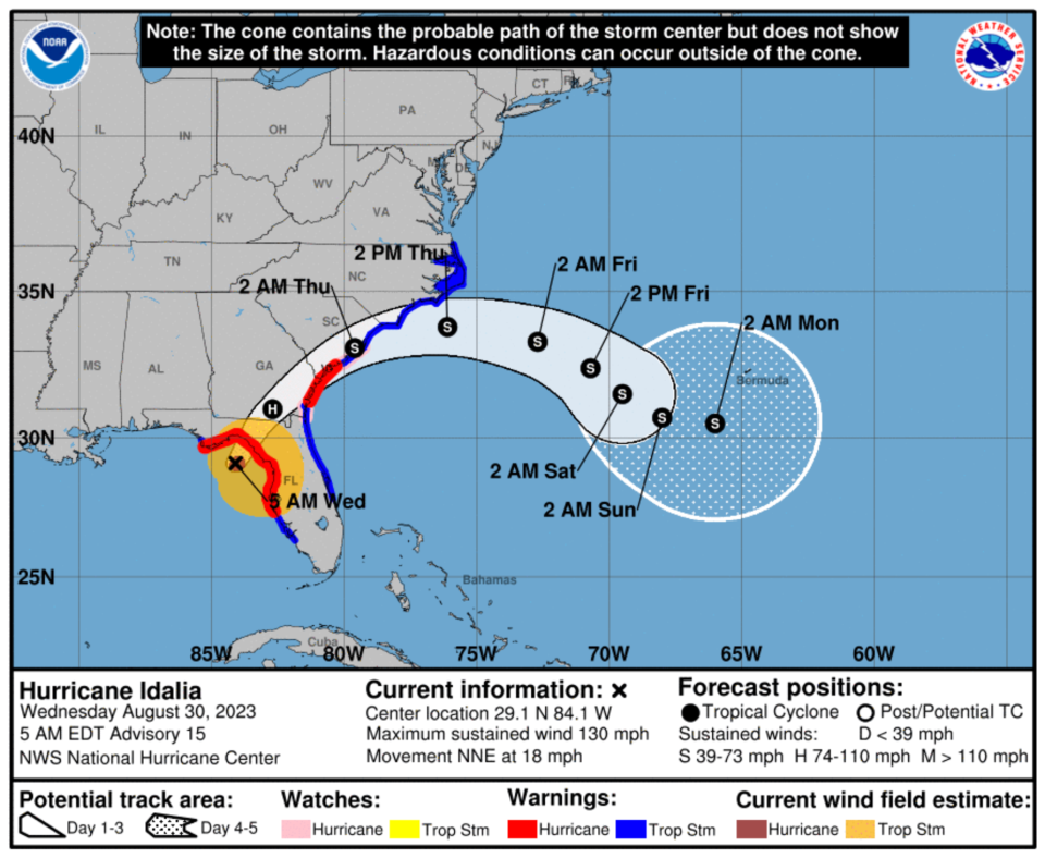
Idalia intensifies to Category 4, tornado watches issued for parts of Georgia
Early Wednesday morning, Hurricane intensified to a Category 4 storm, just hours before it is expected to make landfall in Florida.
"On this track, and potentially factoring in a little more angling to the east, Idalia will be ashore somewhere south of Perry in central Taylor County between 8 and 9 a.m.," said Ryan Truchelut, chief meteorologist for WeatherTiger, in a report for the Tallahassee Democrat.
WeatherTiger Hurricane Idalia updates: Category 4 storm still strengthening
The National Hurricane Center said this storm will bring "catastrophic storm surge and destructive winds" to the Florida coast. A Category 4 storm has winds of 130-156 mph and has the probability of catastrophic damage, according to the National Weather Service.
The NWS issued a tornado watch early Wednesday for much of south and coastal Georgia, stretching from Valdosta to Savannah and up to Screven County.
5am EDT 30 Aug: #Idalia has become an extremely dangerous Category 4 hurricane, and is nearing landfall in Florida Big Bend region this morning. Catastrophic & life-threatening impacts from Storm Surge & Winds expected as Idalia moves ashore. https://t.co/y75tVkKVK7 pic.twitter.com/0NfINii9Mo
— National Hurricane Center (@NHC_Atlantic) August 30, 2023
Savannah, Ga. preparing for Hurricane Idalia, curfew in consideration
The City of Savannah announced that Mayor Van Johnson, II will declare a state of local emergency effective Aug. 30 at 6 a.m. The state of local emergency allows the city manager "to execute emergency management plans and procure necessary resources to prepare for and respond to any impacts brought on by Hurricane Idalia," the press release said.
Savannah is considering a curfew on Wednesday at 6 p.m. until Thursday at 6 a.m. "if weather conditions necessitate a curfew be put in place for public safety," according to a release at 4:20 p.m. Tuesday. An official announcement will be made public if the curfew is enacted. Residents are urged to limit travel on Wednesday.
More: Tropical storm and storm surge watches in affect for Tropical Storm Idalia
How will King Tides affect the Savannah area's potential for flooding?
Heavy rains regularly bring flooding to coastal Georgia, but Idalia's arrival is syncing up with another flood-inducing condition on the coast: King tides. King tides are exceptionally high tides that take place during full or new moons due to the moon's gravitational pull and impact on tides. When storms and heavy winds combine with high tides it can exacerbate flooding not only on the coast but up rivers and streams, as well.
"As of right now we're looking at 4 to 6 inches of rainfall, and we do have an astronomical high tide or a 'king tide' that is coming for Wednesday night," Jones from CEMA said. "With that extremely high tide coupled with the rainfall, there is a potential for us to have water encroachment across Highway 80 going out to Tybee Island."
In this case, which happens a few times every year according to Jones, Tybee could be cut off and isolated for a few hours. He said CEMA is also keeping an eye on the Burnside Island area, which also has the potential to be isolated, as well as other low-lying areas that tend to have the worst flooding impacts.
This article originally appeared on Savannah Morning News: Hurricane Idalia live updates from Savannah, coastal Georgia

