Hurricane Idalia has made landfall, here’s when it will reach Columbia, SC area
Hurricane Idalia has made landfall in the southeastern U.S., and it’s forecast to reach South Carolina later Wednesday, the National Weather Service said.
Idalia might be a Category 1 hurricane when it reaches South Carolina and moves along the coast, National Weather Service Head of Meteorologists Richard Okulski told The State. It will continue to weaken, but at least will be a strong tropical storm when it impacts the Columbia area, Okulski said.
Regardless of its classification, Idalia will produce severe and potentially dangerous weather effects in the Midlands, according to the National Weather Service.
And the Midlands could start to experience those effects as soon as midday, Okulski said.
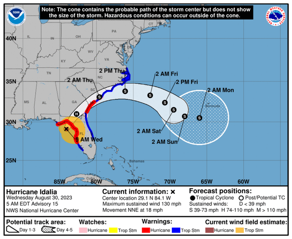
A tropical storm watch is in effect in Columbia, as well as Richland, Lexington and Kershaw counties, the National Weather Service said. A tropical storm warning is in effect for Sumter, Clarendon, Calhoun and Orangeburg counties, according to the National Weather Service.
“We’re going to begin seeing the weather deteriorate this morning into the afternoon as winds are going to pick up,” Okulski said.
What will begin as breeziness will become more powerful, and gusts in excess of 40 mph are possible overnight, with peak hours for the strongest winds around midnight, according to Okulski. But those gusts will continue through 8 a.m. Thursday, the National Weather Service said.
A threat of tornadoes in the Midlands is possible, but Okulski said it’s minimal risk. There’s a greater chance of tornadoes to the east of Columbia, and toward the South Carolina coast, according to Okulski.
Powerful winds and tornadoes could cause considerable damage to trees and branches, in addition to mobile homes, roofs and outbuildings. Vehicles would also be under siege in the case of a tornado.
Damage to trees and branches creates the possibility of downed power lines and outages.
But the greatest threat being posed to the Columbia area by Idalia is excessive rainfall that could lead to flooding.
Rain caused by Idalia could begin by 3 p.m., and the bulk of the showers and thunderstorms will continue to douse the Midlands through 3 a.m. Thursday, Okulski said. The intensity will continue in the evening and overnight, according to the National Weather Service.
Up to 5 inches of rain is possible in Columbia, while other areas of the Midlands, further to the east, could get up to 8 inches of rain, according to Okulski. Localized rainfall amounts could be higher.
“This will be extremely heavy rainfall and it will create challenges with flash flooding,” Okulski said.
The National Weather Service issued a flood watch for all of the Midlands, and it remains in effect until Thursday afternoon — after the rains have moved out of the area. All of the Midlands is at risk of flash flooding, according to the National Weather Service.
Heavy rain and possible floods will pose threats to drivers, especially those on the road during rush hour on Wednesday evening and those making the Thursday morning commute, when visibility might be limited, according to Gropp.
“With that much rain in 12 hours, if you don’t have to go anywhere it’s best to stay home,” Okulski said. “It will be treacherous driving.”
Conditions are expected to improve by sunrise Thursday, but river flooding remains a threat Thursday and through the weekend, according to the National Weather Service.
Idalia would be the first hurricane or tropical storm to affect the Columbia area in 2023, according to the National Weather Service. Last year, the remnants of Hurricane Ian and Tropical Storm Nicole doused the Midlands in October and November, respectively.
As of 8 a.m. Wednesday, the storm was moving northeast at 13 mph, and had maximum sustained winds of 110 mph, according to the National Hurricane Center.

