Tropical Storm Idalia moving across coastal SC. Tornado flips car, flooding reported
Hurricane Idalia hit Florida's Big Bend on Wednesday morning as a Category 3 tropical cyclone before making its way north and northeast toward the South Carolina coast.
Around 9 a.m., Idalia was centered about 25 miles south of Valdosta, Georgia, and more than 200 miles away from South Carolina's Lowcountry. It's speeding north-northeast at 18 mph with sustained winds easing to 105 mph, still clocking in as a Category 2 hurricane.
The National Weather Service forecasts that Idalia will be at hurricane strength as it reaches southeast Georgia late Wednesday afternoon before becoming a tropical storm as it tracks along the South Carolina coast. NWS also stated a flood watch in southeast South Carolina will be in effect through Wednesday.
We will bring you the latest updates from the coast as we continue to track the storm.
Lowcountry SC Hurricane Idalia updates: Here's the latest as storm moves toward coastal SC
Tropical Storm Idalia: Strong winds, flooding on SC coast
The storm was bringing strong winds to Savannah, Georgia, Wednesday evening as it made its way toward the Carolinas. It was forecast to pass over Charleston, South Carolina, early Thursday morning before turning east and heading out to the Atlantic Ocean.
Idalia spawned a tornado that briefly touched down in the Charleston suburb of Goose Creek, the National Weather Service said. The winds sent a car flying and flipped it over, according to authorities and eyewitness video. Two people received minor injuries.
Along South Carolina's coast, North Myrtle Beach, Garden City, and Edisto Island all reported ocean water flowing over sand dunes and spilling onto beachfront streets Wednesday evening. In Charleston, storm surge from Idalia topped the seawall that protects the downtown, sending ankle-deep ocean water into the streets and neighborhoods where horse-drawn carriages pass million-dollar homes and the famous open-air market.
Preliminary data showed the Wednesday evening high tide reached just over 9.2 feet (2.8 meters), more than 3 feet (0.9 meters) above normal and the fifth-highest reading in Charleston Harbor since records were first kept in 1899.
Associated Press
Tropical Storm Idalia moving across coastal South Carolina
Tropical Storm Idalia is moving across coastal South Carolina with maximum sustained winds of 65 mph, according to the 8 p.m. update from the National Hurricane Center.
The storm is currently 60 miles west of Charleston and moving northeast at 21 mph.
"Dangerous coastal inundation is going across much of the lower South Carolina coast," wrote The National Weather Service at 8 p.m. on Twitter. "Do not go to the beach and stay out of flood waters. Tide levels in the Charleston Harbor are now over 9..03 ft MLLW (3.27 ft MHHW). This is a dangerous situation!"
URGENT: Dangerous coastal inundation is going across much of the lower South Carolina coast. Do not go to the beach and stay out of flood waters. Tide levels in the Charleston Harbor are now over 9..03 ft MLLW (3.27 ft MHHW). This is a dangerous situation! #chswx #scwx
— NWS Charleston, SC (@NWSCharlestonSC) August 30, 2023
Power outages reported. Flash Flood Warning in effect for SC coast
Combined, there are nearly 40,000 Dominion and Palmetto customers without power as of 7:20 p.m. Wednesday.
A Flash Flood Warning is in effect for Walterboro, Smoaks and Lodge South Carolina until 8:45 p.m. EDT, according to a Tweet from the National Weather Service in Charleston.
Significant coastal inundation will occur along much of the lower South Carolina coast over the next few hours, including downtown Charleston, according to NWS Charleston. If you live near marshes, beaches, sounds or harbors along the coast, be sure all preparations for high tide are finalized.
Flooding was reported in the areas of Jackson Street and Willard Street in the Town of Hampton, according to the Town of Hampton Facebook page.
#URGENTIDALIAUPDATE: The Battery is now completely flooded and roads are being closed. @Live5News #chsnews pic.twitter.com/UzlL2gYG1z
— Emily Johnson | Live 5 News (@EmilyJohnsonTV) August 30, 2023
Tornado appears to flip car in Charleston
As the rain came down in sheets across the South Carolina Lowcountry Wednesday afternoon, punctuated by rolling thunderstorms and occasional wind gusts, multiple tornado warnings were popping up on the radar from coastal Charleston and Beaufort counties inland to Hampton and Bamberg counties.
As of 5:45 p.m. officials with the National Weather Service in Charleston, which covers the service area of lower South Carolina and southeast Georgia, said they could not confirm the number of tornado warnings so far, or the number of actual tornadoes, as they are "ongoing as we speak."
One possible twister reportedly flipped a car on a highway outside the city of Charleston.
A post on Twitter/X appears to show "a brief, weak tornado spawned by Hurricane Idalia flip a car on a highway outside of Charleston," according to AccuWeather.
The video was widely shared on a variety of social media channels including WeatherNation, and LiveStormChasers.
SC Gov. McMaster encourages residents to stay home
South Carolina Gov. Henry McMaster is issuing no evacuations and isn't closing state offices with storm Idalia forecast to move along the state’s coast overnight.
“This is not as bad as some we’ve seen,” McMaster, who has ordered at least three coastal evacuations since taking office in 2017, said Wednesday. But, he said, the state is ready to respond if the storm is worse than anticipated — and he encouraged people to stay home.
Flooding could be the state's biggest threat. Wednesday evening’s high tide in Charleston Harbor is forecast to be nearly 9 feet (2.7 meters) above normal sea level or about 3 feet (just under 1 meter) above normal high tide.
The city opened parking garages so people could park well above ground and gathered barricades to close off streets in the low- lying city, which frequently floods whenever tides are above normal.
Hilton Head Island emergency manager Tom Dunn said as much as 6 inches (15 centimeters) of rain combined with a potential storm surge of 4 feet (1.2 meters) could put parts of the island underwater, as when Hurricane Irma passed by after striking Florida in 2017.
Associated Press
Tornado Warning issued for Charleston area
The National Weather Service issued a Tornado Warning for Charleston, North Charleston and Mount Pleasant until 4 p.m.
Tornado Warning including Summerville SC, Ladson SC and Lincolnville SC until 4:15 PM EDT pic.twitter.com/Srd6VZCbK1
— NWS Charleston, SC (@NWSCharlestonSC) August 30, 2023
Tornado Warning including Summerville SC, Ladson SC and Lincolnville SC until 4:15 PM EDT pic.twitter.com/Srd6VZCbK1
— NWS Charleston, SC (@NWSCharlestonSC) August 30, 2023
National Weather Service: Idalia brings rain, rain and just a bit more rain
The Upstate will have a rainy evening as Idalia continues to track to the south of us. The National Weather Service also warns of some moderate to heavy rainbands being possible as the storm continues to move.
Rain 🌧️ will continue to spread in across the area from the south this afternoon as Idalia tracks to our south, with some embedded moderate to heavy rainbands possible this evening. #ncwx #scwx #gawx #cltwx #gspwx #avlwx ☂️ pic.twitter.com/GYKqddsxoJ
— NWS GSP (@NWSGSP) August 30, 2023
Gov. Henry McMaster holds press conference on SC's Hurricane Idalia preparedness
Gov. Henry McMaster's office held a press conference Wednesday afternoon to provide an update on South Carolina's preparation efforts.
McMaster said no state offices will be closed and no evacuations will be ordered as a result of Hurricane Idalia.
Hurricane Idalia impact
South Carolina Lowcountry is in the path of Idalia as it moves up the coast on Wednesday.
The NWS predicts that the Greenville, Spartanburg and Anderson area will see some gusty wind and bands of rain drenching the area as Idalia weakens.
Find out more here.
SC declares a state of emergency, price gouging laws in effect
Ahead of Idalia, South Carolina Gov. Henry McMasters declared a state of emergency on Tuesday. McMaster warned residents should take precautions despite the state likely missing the "worst of Hurricane Idalia’s impacts."
"Although South Carolina may avoid the worst of Hurricane Idalia's impacts, this State of Emergency is issued out of an abundance of caution to ensure that we have the necessary resources in place to respond to flooding events and are able to respond quickly if the forecast worsens," McMasters said in a release.
The S.C. Attorney General announced that price gouging laws were in effect because of the declaration as well.
“With the possibility that Hurricane Idalia could hit South Carolina after making landfall in Florida, we all need to be prepared. We can expect normal price increases, and those are not considered price gouging under our law. But we may see businesses and individuals looking to unfairly take advantage of the situation through price gouging of food, gasoline, lodging, and other commodities as defined by the statute. By our law, that’s a criminal violation and an unfair trade practice,” S.C. Attorney Alan Wilson said.
Follow the path of Hurricane Idalia
The latest path for Hurricane Idalia as it moves north, northeast.

Where did Idalia make landfall?
Radar imagery indicated the eye of Idalia made landfall along the coast of Florida's Big Bend near Keaton Beach in Taylor County around 7:45 a.m., the National Hurricane Center said.
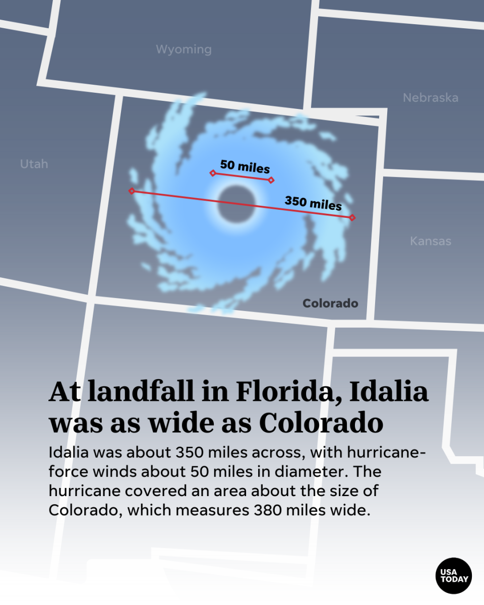
Idalia ranks among the 20 most powerful storms to make landfall in Florida since modern recordkeeping began more than a century ago, according to the National Oceanic and Atmospheric Administration.
Tornado Warning issued for Charleston area
The National Weather Service issued a Tornado Warning for Charleston, North Charleston and Mount Pleasant until 4 p.m.
This article originally appeared on Nashville Tennessean: Tropical Storm Idalia in SC updates: McMaster issues no evacuations.

