Hurricane Idalia updates: Tropical Storm Warning issued for Wilmington area
LIVE UPDATES ON HURRICANE IDALIA: The latest on impacts in Wilmington
Hurricane Idalia continued to intensify Tuesday and is expected to grow into a category 3 monster before slamming into the Gulf Coast of Florida early Wednesday.
Idalia is projected to pass through the Wilmington area as a tropical storm, with rain and wind beginning here late Wednesday into early Thursday.
The National Weather Service (NWS) issued a tropical storm warning for Southeastern North Carolina at 5 p.m. Tuesday, Aug. 29. That means tropical storm conditions are possible within 36 hours.
As of 11 p.m., Hurricane Idalia had maximum sustained winds of 110 mph and was moving north at 18 mph.
On Tuesday afternoon, the NWS issued a flood watch that remains in effect until 8 p.m. Thursday.
Tuesday morning, N.C. Gov. Roy Cooper declared a state of emergency to activate the state’s emergency operations plan.
"We are continuing to monitor Idalia’s course and its potential impacts on our state and it’s critical to make sure we are fully prepared," Cooper said in a news release. "It is important for North Carolinians to gather emergency kits and prepare for the storm before it’s too late."
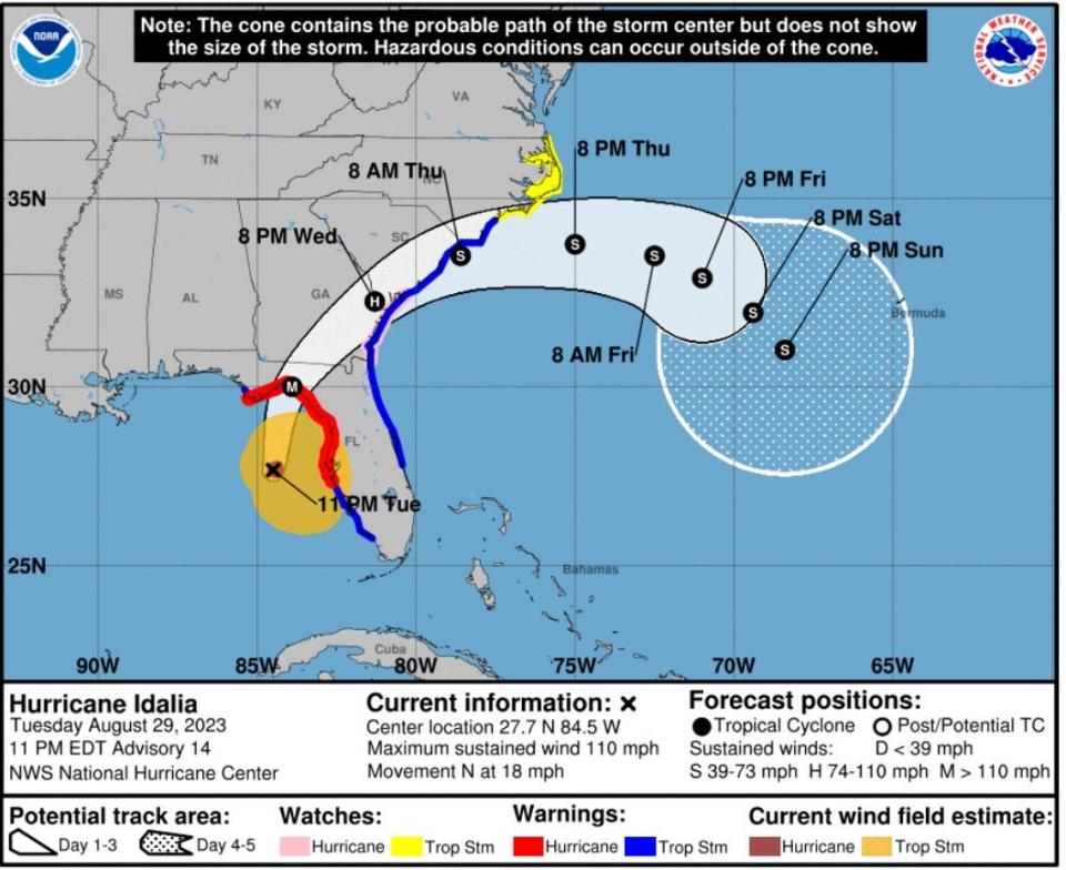
Matt Scalora, meteorologist with the National Weather Service's Wilmington office, said the storm's track shifted "a little more westward" overnight, which increases the risk of tornadoes in the area. The National Weather Service's 11 a.m. update had the track shifting slightly to the west again.
TRACK THE STORM: See the latest updates on the path of Hurricane Idalia.
Here's a look at what we can expect in the Wilmington area, according to the latest briefing from the National Weather Service:
WIND: Tropical storm force winds (over 40 mph) are likely for parts of the region. Downed trees and isolated power outages are possible. Winds will probably be highest Wednesday night and Thursday morning, with sustained winds of 30 to 40 mph and gusts as high as 55 mph. Again, tornadoes and waterspouts are possible.
RAIN: The area could see between 4 and 8 inches of rain, which will likely result in some flooding in low-lying areas and places with poor drainage. Road closures are possible. Heaviest rain is expected to be Wednesday night and Thursday morning, with 4 to 6 inches along the I-95 corridor and 6 to 8 inches along the coast.
STORM SURGE: The briefing said there's also "potential for some storm surge" and coastal inundation, especially during high tides around 8 p.m. Wednesday and 8 a.m. Thursday. Any storm surge impacts are likely to be limited.
MARINE: Maritime conditions will continue to be hazardous, due not only to Idalia, but also to Hurricane Franklin, a major hurricane off the Atlantic Coast. The risk of dangerous rip currents is expected to last through the end of the week.
A guide for hurricane season: Supplies, shelters, evacuations and more
More: What are the 5 worst hurricanes to ever hit the Wilmington area?
TRASH & DEBRIS: According to a post from the city of Wilmington's official Facebook page, due to expected stormy conditions, people who usually have trash, yard waste and recycling collected on Thursday will have it collected this week on Wednesday instead.
After the storm has passed, all debris "for city collection MUST meet the yard waste preparation and volume requirements. That information can be found here: https://bit.ly/3Z23C7N."
This article originally appeared on Wilmington StarNews: Hurricane Idalia what to expect in Wilmington

