Hurricane Isaias makes landfall in the Bahamas

Hurricane Isaias continued to lash the Bahamas with strong winds and heavy rain early Saturday as it crept closer to the coast of the mainland United States. Isaias, packing winds of 80 mph, crashed ashore in Andros Island of the Bahamas early Saturday.
At 11:00 a.m., EDT, the National Hurricane Center (NHC) reported that the Hurricane Isaias was making landfall over the northern portion of Andros Island, the largest and southernmost island of the archipelago. The Category one storm was only a mere 40 miles west-southwest of the Bahamian capital of Nassau. Forecasters said that the storm was continuing to move to the northwest at a speed of 12 mph. The storm had slowed down from its pace of 18 mph on Friday.
The Associated Press reported that there was roof damage and tree damage across parts of the archipelago early Saturday.
 |
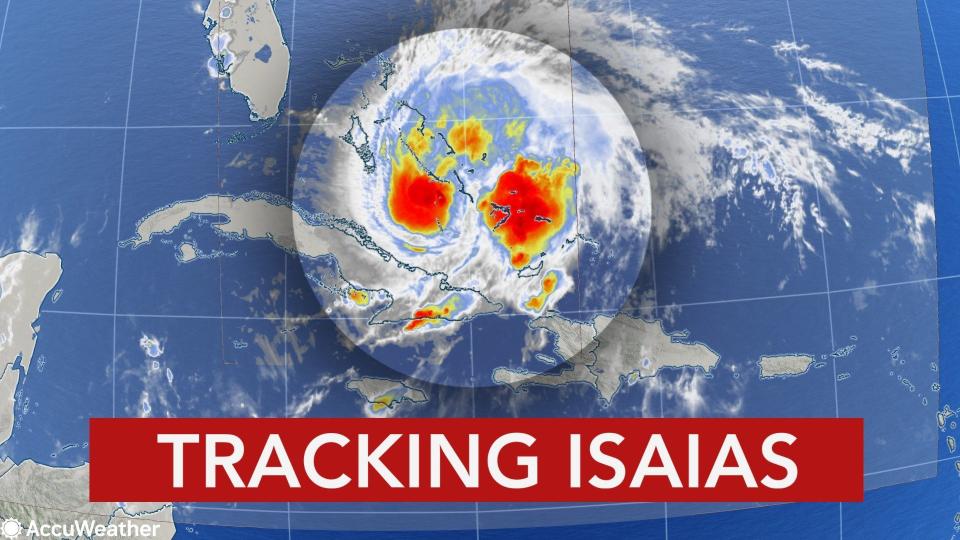
A satellite image showing Hurricane Isaias churning through the Bahamas and heading for Florida on Aug. 1, 2020. The system was described as having a "ragged" eye by the National Hurricane Center early Saturday. (NOAA / GOES-East) |
As the storm closed in on the Bahamas, residents were still rushing to complete preparations for the storm on Saturday, Paula Miller, Mercy Corps director for the Bahamas, told the AP, adding that people were still in long lines to buy gas on Grand Bahama.
"People are doing the best they can to prepare, but a lot of businesses still have not fully repaired their roofs or their structures" since devastating Hurricane Dorian struck in 2019, Miller said. "Even a lower level storm could really set them back."
Government officials and residents in Florida were in full preparation mode on Friday. Florida Gov. Ron DeSantis declared a state of emergency in every coastal county of Florida's Atlantic Coast, stretching from Miami-Dade to Nassau counties, on Friday in preparation for the storm. Meanwhile, the NHC issued a hurricane warning for portions of Florida's Atlantic coast.
Later Friday evening, DeSantis requested a pre-landfall emergency declaration from President Donald Trump ahead of Isaias.
Residents in Florida were bracing for impact and stocking up on essentials ahead of Isaias' potential arrival, all while wearing masks -- a sign of the confluence of hurricane season with a global pandemic.
 |
Isaias rapidly strengthened into a Category 1 hurricane Thursday night, shortly after pulling away from Hispaniola. AccuWeather forecasters expect it to make a run along the Eastern Seaboard of the United States this weekend into early next week and could result in a multibillion dollar disaster.
Hurricane warnings were in effect for the Bahamas on Friday, including hard-hit areas from Dorian in 2019 like the Abaco Islands, although meteorologists expect the impacts to pale in comparison to the monster storm that stalled for 24 hours and caused utter devastation there last year. By Friday evening, the government of the Bahamas discontinued the hurricane warning for the southern Bahamas and the tropical storm warning for the Turks and Caicos was also discontinued.
"Isaias is rated a 1 on the AccuWeather RealImpact™ Scale for Hurricanes in the Bahamas and the coastal southeastern U.S. due to flooding and damaging winds," AccuWeather Senior Meteorologist Rob Miller said. This scale is a more nuanced method the company introduced in 2019 to assess the potential damage a tropical system could cause.
AccuWeather estimates the total damage and economic loss caused by Isaias will be $3 billion and could be as much as $5 billion should it reach Category 2 status on the Saffir-Simpson scale before approaching the east coast of Florida, according to AccuWeather founder and CEO Joel N. Myers. The estimate is based on an analysis incorporating independent methods to evaluate all direct and indirect impacts of the storm and is based on a variety of sources, statistics and unique techniques AccuWeather uses to estimate damage.
AccuWeather's estimate includes damage to homes and businesses as well as their contents and cars, job and wage losses, infrastructure damage, auxiliary business losses, medical expenses and school closures. The estimates also account for the costs of power outages to businesses and individuals and for economic losses because of highway closures and evacuations, as well as extraordinary government expenses for cleanup operations.
Isaias's recent strengthening will help the hurricane forge a track more to the north. And the system could potentially strengthen even more over the very warm waters of the Gulf Stream, especially since Isaias is now expected to avoid the large land mass of Cuba this weekend. While a track up part of the Florida Peninsula is still possible, forecasters have ruled out a track toward the Gulf of Mexico with these developments.
Conditions will deteriorate rapidly from south to north over the Bahamas and the eastern part of the Florida Peninsula this weekend as Isaias takes a northwestward, then northward path over the warm waters of the Gulf Stream. How far west versus east Isaias tracks and exactly how strong and large the eye wall becomes will determine the severity of conditions in the Bahamas and along the Florida Atlantic coast.
CLICK HERE FOR THE FREE ACCUWEATHER APP
The National Guard released dramatic flood rescue video from Puerto Rico, showing young children and infants being pulled from high waters left behind after Isaias's torrential downpours. Parts of the island picked up more than 10 inches of rain as Isaias moved just south of the island on Thursday. In the Dominican Republic, officials blamed at least one death on the storm's impacts, The Associated Press reported.
 |
AccuWeather meteorologists expect Isaias to fluctuate in strength through this weekend with intensity ranging from a Category 1 hurricane to a tropical storm. While some additional strengthening is possible, Isaias is expected to fall just short of Category 2 strength. A Category 1 hurricane has winds ranging from 74 to 95 mph, while a Category 2 hurricane has winds of 96 to 110 mph. A tropical storm has winds of 39 to 73 mph.
Isaias will be moving over water that is very warm this weekend, with temperatures ranging from 84 to 90 degrees Fahrenheit, which is more than sufficient to allow for abrupt strengthening. However, wind shear may factor into the storm's future into this weekend and beyond.
Wind shear is the increase in wind speed or direction with altitude or across a horizontal distance. When wind shear is strong, hurricanes and tropical storms can weaken and potential tropical systems may fail to develop. Since wind shear is almost never in a constant state, it can lead to fluctuations in strength, structure and forward speed of tropical storms and hurricanes as they move along.
 |
"Wind shear can cause Isaias to weaken for a time into Friday night and perhaps again before approaching the Carolina coast [next week]," Miller said. Officials along the North Carolina coast weren't taking any chances given the possibility of a strike by Isaias. Mandatory evacuations were issued Friday on Ocracoke Island, one of the places hardest hit last year by Hurricane Dorian.
"The forward speed of Isaias will also fluctuate, meaning that Isaias's speed can slow down a bit for a time," Miller added.
However, this will not evolve into another situation like Hurricane Dorian from 2019, which stalled over the Bahamas for days. Isaias will keep moving, and it is not expected to be nearly as strong as Dorian. Impact on Florida and the Bahamas may be similar to or perhaps not as severe as that of Matthew from September 2016, provided the eyewall of the storm does not reach much of Florida's east coast.
Rainfall and tropical-storm-force winds will continue to advance northward through the Bahamas into Saturday night and are projected to reach southeastern Florida, including Miami, late Friday night to early Saturday morning and then spread northward over the eastern half of the Florida Peninsula this weekend. Seas and coastal water levels will also build in advance of the storm by roughly 24 hours. People along the coast can expect a quickening breeze and increasing surf and rip currents in advance of the storm as well.
 |
"Widespread rainfall amounts of 2-4 inches can be expected over the Bahamas and the eastern part of the Florida Peninsula, with totals of 4-8 inches with an AccuWeather Local StormMax™ of 10 inches over the western Bahamas," Miller said.
The fast-forward motion of Isaias should limit the overall amount of rain, but there can still be incidents of urban flooding in the Bahamas and from Florida to the Carolinas. But, a track farther to the east would bring less rain to the U.S. and more rain to the Bahamas, for example.
 |
"While current projections have the eye of Isaias remaining at sea, the situation remains fluid and can change quickly," DeSantis said at a press conference on Isaias Friday. The Florida division for emergency management created new guidance on opening shelters amid the pandemic should they become necessary, he added. DeSantis called on Floridians to remain vigilant and heed warnings.
Florida officials have been urging residents to prepare for days, especially as the state responds to another disaster: the coronavirus pandemic. The state has been experiencing a tremendous surge in COVID-19 cases over the last month. On Friday, Florida reported a record number of COVID-19 fatalities for the fourth straight day, bringing the total death toll there since the pandemic began to nearly 7,000, data from John Hopkins University shows.
 |
Still, officials are preparing for the worst in case shelters need to be opened to keep residents safe from the hurricane, which is expected to run up the Sunshine State's coast this weekend.
"We have 20 evacuation centers on standby, they're not open, should they need to open them, should we need to open them and we will have them set up with COVID-19 safety measures. It's really too early to tell yet, so we're closely monitoring the situation," Miami-Dade Mayor Carlos A. Gimenez said at a press conference about hurricane preparation.
Floridians headed to stores late this week to stock up on supplies ahead of the storm, and DeSantis warned people to be prepared for possible power outages on top of adding coronavirus-related items to storm kits, such as hand sanitizer and extra masks.
 |
Shoppers stock up on groceries to prepare for Hurricane Isaias at a Costco store in Palm Beach Gardens, Florida, on July 31, 2020. (Greg Lovett/Palm Beach Post via USA TODAY NETWORK) |
"Wind gusts of 60-70 mph can occur over the Bahamas and eastern Florida through the weekend, with an AccuWeather Local StormMax™ wind gust of 80 mph possible in eastern Florida and 100 mph expected in the western parts of the Bahamas," Miller said.
In the Bahamas, damage to some trees, poorly constructed buildings and temporary structures should be anticipated. Power outages may result, and disruption of electricity may last several days in more remote areas.
 |
Sporadic power outages are possible along the east coast of Florida. Residents and property owners should secure loose items and protect windows from flying debris that often accompanies storms of this magnitude.
Residents along the southeastern and mid-Atlantic coasts of the U.S. were also being urged to closely monitor the storm's track and strength in the coming days. As Isaias continues to move northward, impact from rain, wind and storm surge will move northward as well along the southeastern U.S. coast.
A storm surge of 3-6 feet is forecast in the northwestern Bahamas with 1-3 feet likely along much of the Florida east coast and along the shoreline of Georgia and South Carolina. Depending on the track of Isaias, which may include a landfall, a storm surge of 3-6 feet is possible in parts of eastern North Carolina and perhaps southeastern Virginia.
 |
"A general 2-4 inches of rain can occur early next week over the eastern Carolinas with wind gusts of 50-60 mph with an AccuWeather Local StormMax™ wind gust of 80 mph," Miller said.
A non-tropical storm system will have an affect on Isaias upon nearing the U.S. coast.
 |
"We sometimes see jet stream troughs like this draw tropical systems closer in to the U.S., rather than drive them away," AccuWeather Chief Broadcast Meteorologist Bernie Rayno said.
The storm will tend to draw the storm closer to the coast for a time, before likely shoving the system off to the northeast.
How quickly the northeast turn occurs early next week will determine whether landfall occurs along the North Carolina coast and perhaps other points in the mid-Atlantic and New England, or perhaps if the storm moves just inland over these areas or perhaps stays just offshore.
North Carolina Gov. Roy Cooper issued a state of emergency for portions of the state on Friday and urged residents to prepare for the hurricane.
"Although the track and arrival of the hurricane could still change, now is the time for North Carolinians to prepare," Cooper said. "Hurricane preparations will be different given the COVID-19 pandemic, and families need to keep that in mind as they get ready."
North Carolina Emergency Management (NCEM) readied the National Guard should they need to respond to flood rescues, and the North Carolina Department of Transportation were also on standby with equipment should they need to respond to storm damage early in the week.
 |
Following a slow-down in forward speed this weekend, an increase in forward speed of the storm seems likely next week, so stormy conditions may be brief and limited to less than 24 hours at any one spot in the Northeast.
Hurricane Isaias, pronounced ees-ah-ee-ahs, is already one for the record books. It was named Isaias when it strengthened to a tropical storm Wednesday night -- and, with its upgrade from the National Hurricane Center (NHC), became the earliest "I-storm" in recorded history, surpassing Irene, which formed on Aug. 7, 2005.
It has been 25 years since a hurricane tracked through the Bahamas so early in the season, specifically prior to the middle of August. Erin strengthened into a Category 1 hurricane near Rum Cay in the Bahamas and moved through the island chain on Aug. 1-2, 1995, according to Colorado State tropical meteorologist Philip Klotzbach. The storm passed over the Abaco Islands and Grand Bahama, causing generally minor damages, before heading toward Florida.
Isaias could become the second named system to make landfall in the U.S. in about a week's time following Hanna's arrival as a Category 1 hurricane in South Texas on Saturday, July 25. But after Isaias' abrupt strengthening Thursday night, the system's curved path could keep most of the hurricane-force winds east of the U.S. coastline.
The Atlantic basin is showing no signs of letting up in the coming weeks, and forecasters are already busy monitoring two other areas of concern. AccuWeather's top hurricane expert Dan Kottlowski issued an update to the numbers of tropical storms and direct impacts to the United States for the Atlantic season this week. He warned that the tropics could become "hyperactive" as the heart of hurricane season nears, and that one area in particular should remain "very vigilant" of the pattern setting up.
Six of the nine tropical storms thus far in 2020 have set new records for early formation for their respective letters in the basin -- Cristobal, Edouard, Fay, Gonzalo, Hanna and Isaias -- and more are likely to fall as the season progresses, according to forecasters. The "J-storm" record is currently held by Jose on Aug. 22, 2005, with the "K-storm" record held by the infamous Katrina, which formed on Aug. 24, 2005.
The 10th and 11th names on this year's tropical list are Josephine and Kyle. For more names on the 2020 Atlantic list and all tropical weather information, please visit the AccuWeather hurricane center.
It's not just meteorologists who need to keep a close eye on how storms develop and where they're heading. AccuWeather users can now do that from home using our local hurricane tracker pages that provide detailed information about a specific location.
Click on the city name to track how Isaias will impact each place as it churns northward: Miami, Florida; Daytona Beach Florida; Jacksonville, Florida; Myrtle Beach, South Carolina; Hilton Head, South Carolina; Virginia Beach, Virginia; Ocean City, New Jersey; New York City; Boston, Massachusetts.
