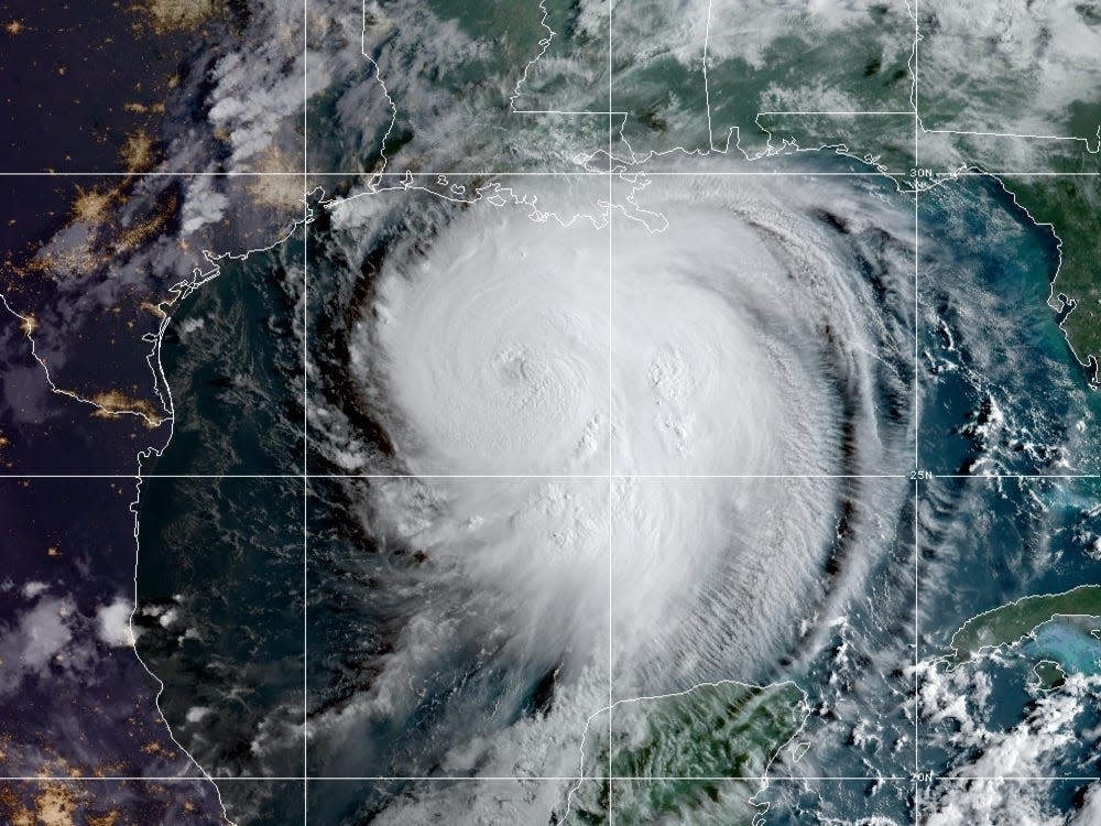
The major hurricane is poised to strengthen even more and make landfall Wednesday night as a Category 4 storm, just days before the 15th anniversary of Hurricane Katrina.
Scientists can't definitively say whether Hurricane Laura or other individual storms are directly caused by climate change, but warming overall makes hurricanes more frequent and devastating than they would otherwise be.
That's because storms feed on warm water, and higher water temperatures also lead to sea-level rise, which in turn increases the risk of flooding during high tides and in the event of storm surges. Warmer air also holds more atmospheric water vapor, which enables tropical storms to strengthen and unleash more precipitation.
"Our confidence continues to grow that storms have become stronger, and it is linked to climate change, and they will continue to get stronger as the world continues to warm," James Kossin, an atmospheric scientist at NOAA who studies how climate change affects tropical cyclones, told the Washington Post.
Here's why storms are getting so much stronger, wetter, and more frequent in the Atlantic.
How a hurricane forms
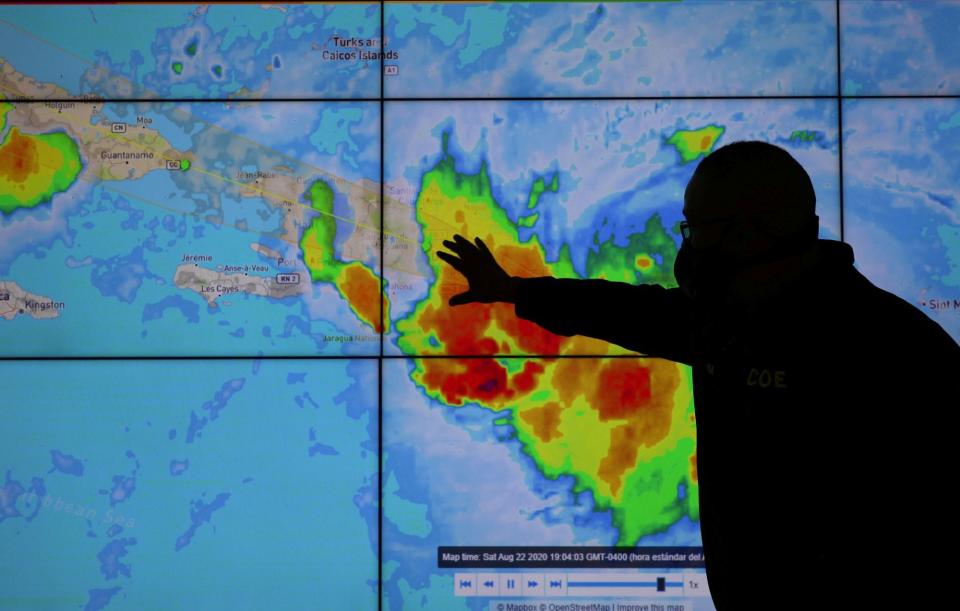
A member of the Emergency Operations Committee monitors the trajectory of Hurricane Laura in Santo Domingo, Dominican Republic, August 22, 2020.
Hurricanes are vast, low-pressure tropical cyclones with wind speeds over 74 mph.
The Atlantic hurricane season generally runs from June through November, with storm activity peaking around September 10. On average, the Atlantic sees six hurricanes during a season, with three of them developing into major hurricanes (Category 3 or above). The storms form over warm ocean water near the equator, when sea surface temperature is at least 80 degrees, according to the National Hurricane Center.
As warm moisture rises, it releases energy, forming thunderstorms. As more thunderstorms are created, the winds spiral upward and outward, creating a vortex. Clouds then form in the upper atmosphere as the warm air condenses. As the winds churn, an area of low pressure forms over the the ocean's surface. At this point, hurricanes need low wind shear — or a lack of prevailing wind — to form the cyclonic shape associated with a hurricane.
Shayanne Gal/Business Insider
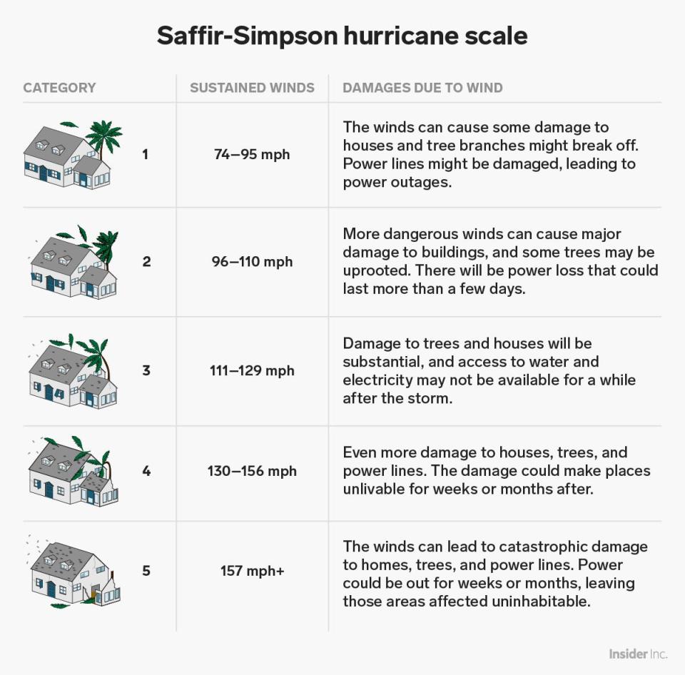
Cyclones start out as tropical depressions, with sustained wind speeds below 39 mph. Once wind speeds pass that threshold, the cyclone becomes a tropical storm. Then above 74 mph, the storm is considered a Category 1 hurricane on the Saffir-Simpson scale.
Samantha Lee/Business Insider
So far this year, the Atlantic Ocean has produced a record 13 tropical storms in just three months. Three have become hurricanes — Hanna, Isaias, and Laura.
The National Oceanic and Atmospheric Administration has predicted an "extremely active" 2020 hurricane season, with 19 to 25 named storms — the first time in NOAA's history the number is that high. The forecast includes seven to 11 hurricanes, with three to six of them reaching Category 3 or higher (that's considered a "major hurricane").
"This is one of the most active seasonal forecasts that NOAA has produced in its 22-year history of hurricane outlooks," US Secretary of Commerce Wilbur Ross said in an August press release, adding, "we encourage all Americans to do their part by getting prepared, remaining vigilant, and being ready to take action when necessary."
Hurricanes are getting stronger
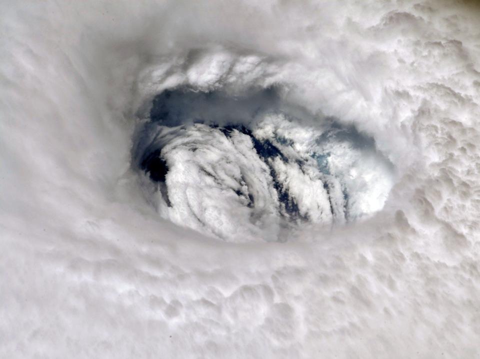
Astronaut Nick Hague, aboard the International Space Station, posted this photograph of Hurricane Dorian to Twitter on September 2, 2019.
As ocean temperatures increase, we're seeing more severe hurricanes. That's because a storm's wind speed is influenced by the temperature of the water below: A 1-degree Fahrenheit rise in ocean temperature can increase a storm's wind speed by 15 to 20 miles per hour, according to Yale Climate Connections.
That's what Laura did this week in its process of rapid intensification — the term for an increase of at least 35 mph in a storm's wind speeds within 24 hours.
"Rapid intensification events are more likely because of climate change," Kossin said.
In a recent study, Kossin's team found that each new decade over the last 40 years has brought an 8% increase in the chance that a storm turns into a major hurricane.
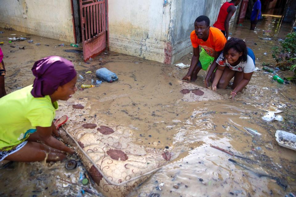
Neighbors help Lafaille Katia (left) pick up a mattress at her flooded house the day after the passing of Tropical Storm Laura in Port-au-Prince, Haiti, August 24, 2020.
Generally, a strong storm also brings a storm surge: an abnormal rise of water above the predicted tide level. If a storm's winds are blowing toward the shore and the tide is high, storm surges can cause water levels to rise as rapidly as a few feet per minute along a coast.
"Almost all of the damage and mortality caused by hurricanes is done by major hurricanes," Kossin told CNN. "Increasing the likelihood of having a major hurricane will certainly increase this risk."
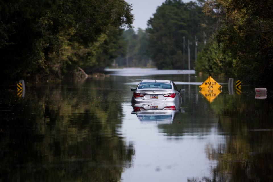
A disabled car is submerged in flood waters from Hurricane Florence in South Carolina in September 2018.
Sean Rayford/Getty Images
Higher sea levels also lead to more destructive storm surges. Unfortunately, even if we were to cut emissions dramatically starting today, some sea-level rise is already inevitable, since the planet's oceans absorb 93% of the extra heat that greenhouse gases trap, and water (like most things) expands when heated.
Storms are moving more slowly and dropping more rain
Over the past 70 years or so, the speed of hurricanes and tropical storms has slowed about 10% on average, according to a 2018 study. Over land in the North Atlantic and Western North Pacific specifically, storms are moving 20% to 30% more slowly, the study showed.
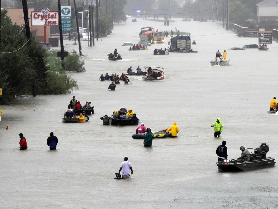
Rescue boats float on a flooded street as people are evacuated from rising flood waters brought on by Tropical Storm Harvey in Houston, August 28, 2017.
That gives a storm more time to pummel an area with powerful winds and rain.
Hurricane Harvey in 2017 was a prime example of this: After it made landfall, Harvey weakened to a tropical storm, but then stalled for days over the Houston area — scientist Tom Di Liberto described it as the "storm that refused to leave."
Climate scientist Michael Mann wrote on Facebook that Hurricane Harvey "was almost certainly more intense than it would have been in the absence of human-caused warming, which means stronger winds, more wind damage, and a larger storm surge."
Hurricane Dorian did something similar last year when it stalled over the Bahamas, pummeling the islands with 185-mph winds and up to 30 inches of rain. Although the country's official death toll was 74, Dr. Duane Sands, who served as the Minister of Health at the time, has said the true death toll "remains unknown," according to the Miami Herald.
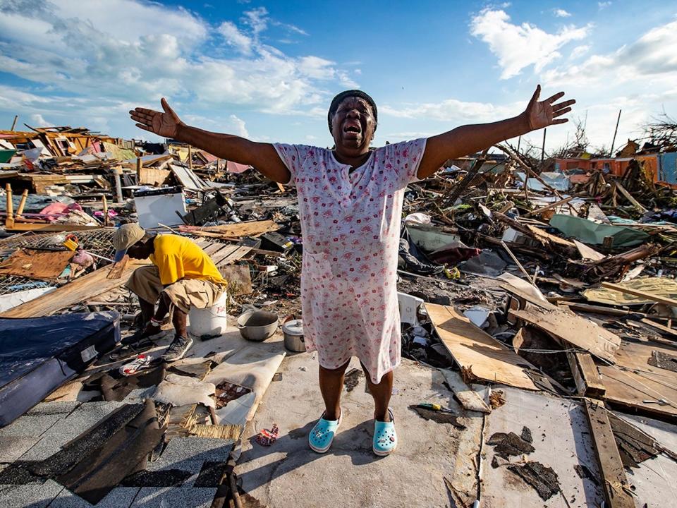
Aliana Alexis of Haiti stands on the concrete slab of what is left of her home after destruction from Hurricane Dorian in an area called "The Mud" at Marsh Harbour in Great Abaco Island, Bahamas on Thursday, September 5, 2019.
Al Diaz/Miami Herald/Tribune News Service via Getty Images
Former NBA guard Darius Morris has died at the age of 33. He played for five teams during his four NBA seasons. Morris played college basketball at Michigan.
Affluent Americans may want to double-check how much of their bank deposits are protected by government-backed insurance. The rules governing trust accounts just changed.
With free agency and the draft behind us, what 32 teams look like today will likely be what they look like Week 1 and beyond for the 2024 season. Matt Harmon and Scott Pianowski reveal the post-draft fantasy power rankings. The duo break down the rankings in six tiers: Elite offensive ecosystems, teams on the cusp of being complete mixed bag ecosystems, offensive ecosystems with something to prove, offenses that could go either way, and offenses that are best to stay away from in fantasy.
It’s key to note that we’re not saying the “best team” or “best roster.” Instead, we’re talking about the best confluence of factors that can outline a path for survival and then success.
Jake Mintz & Jordan Shusterman discuss the Padres-Marlins trade that sent Luis Arraez to San Diego, as well as recap all the action from this weekend in baseball and send birthday wishes to hall-of-famer Willie Mays.
An annual government report offered a glimmer of good news for Social Security and a jolt of good news for Medicare even as both programs continue to be on pace to run dry next decade.
Budgeting apps can help you keep track of your finances, stick to a spending plan and reach your money goals. These are the best budget-tracking apps available right now.
Minneapolis Fed president Neel Kashkari said interest rates will likely stay at current levels for an "extended period" and didn't rule out a hike if inflation stalls near 3%.