Hurricane Lee to affect U.S. East Coast up into Canada; new depression expected in Atlantic
Hurricane Lee’s trajectory is now aimed at New England and coastal Canada, with impacts likely this weekend. Elsewhere in the Atlantic, Hurricane Margot may have reached peak intensity. Farther east, a low-pressure system will likely become a tropical depression by this weekend, according to the latest forecast.
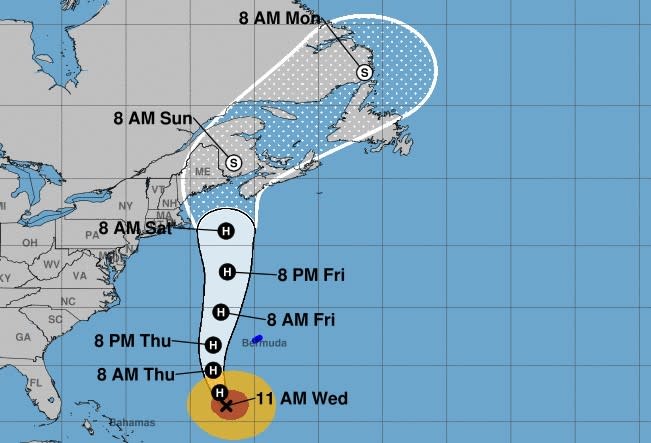
Lee’s arc northwest increases the risk of coastal flooding rain, particularly for New England and Canada later this week. The storm is projected to parallel to the U.S. East Coast over the coming days while accelerating and widening, the National Hurricane Center said.
The National Hurricane Center said in its 11 a.m. update that tropical-storm-force winds could reach Long Island and southern New England by Friday night and the storm will be located off Cape Cod by Saturday morning.
Meteorologist Jeff Berardelli of WFLA-TV in Tampa posted on social media that “the biggest impact from these large fast moving systems … is huge waves and substantial surge.” He shared a map indicating potential wave heights of 10 feet along the south shore of Long Island 16 feet on Cape Cod.
The storm has widened over time and is expected to continue to grow as it accelerates north. Hurricane-force winds extend outward up to 115 miles from the center and tropical-storm-force winds extend outward up to 240 miles.
A tropical storm watch was in effect for Bermuda Wednesday with Lee passing to its west. Bermuda could see up to 2 inches of rain Thursday into Friday, forecasters said.
Related Articles
As of 11 a.m. Wednesday, Lee was about 430 miles south-southwest of Bermuda, moving north-northwest at 9 mph and maintaining top wind speeds of 115 mph, according to the National Hurricane Center.
Last week, Lee went through exceptionally rapid intensification, vaulting from a Category 1 hurricane with maximum sustained winds of 80 mph early Thursday to a dangerous Category 5 storm with 165 mph winds in just 24 hours.
The hurricane center said islands in the far eastern Caribbean, the British and U.S. Virgin Islands, Puerto Rico, Haiti and the Dominican Republic, Turks and Caicos Islands, the Bahamas and Bermuda were experiencing swells from Lee as of Tuesday night.
Forecasters said “dangerous surf and rip currents” were expected to move north along much of the coast and to Atlantic Canada in the next few days.
The weather service added that South Florida beaches will experience “deteriorating beach and boating conditions” by the midweek with a likely risk of deadly rip currents.
As Lee gradually builds swells during the week, there could be some minor beach erosion from rough surf pounding against shore at high tide.
Related Articles
Storms & Hurricanes | What’s next for Florida property insurance in wake of Hurricane Idalia?
Storms & Hurricanes | ‘Really heartbreaking’: DeSantis surveys Hurricane Idalia damage in hard-hit Big Bend area
Storms & Hurricanes | This summer was a global record breaker for the highest heat ever measured, meteorologists say
Lee is expected to move over cooler sea temperatures left in the wake of Hurricane Franklin later in the week. That, along with wind shear and dry air, is expected to weaken Lee steadily late this week and throughout the weekend, forecasters said.
Margot is holding steady as a Category 1 hurricane in the central Atlantic, but its path is forecast to meander in a circular fashion.
The storm has maximum sustained winds of 85 mph, with hurricane-force winds extend outward up to 45 miles from Margot’s center and tropical-storm-force winds extend outward up to 230 miles.
Forecasters said Wednesday that a meandering Margot may have reached its peak intensity and could be a post-tropical cyclone by early next week.
Forecasters also are monitoring a broad area of low pressure moving west-northwest or northwestward across the central Atlantic that is likely to develop into a tropical depression.
As of 8 a.m. Wednesday, the hurricane center said it has an 80% chance of developing in the next seven days and a 50% chance in the next 48 hours.
The season officially runs through Nov. 30. The next named storm will be Nigel.

