Hurricane Lee expected to be Category 5 storm in 12 hours. What can Florida expect?
Hurricane Lee continues to strengthen, with forecasts calling for the storm to be a Category 5 storm within the next 36 hours, according to the National Hurricane Center.
Maximum sustained winds have reached 130 mph, making Lee a strong Category 4 storm, making it the third Category 4 storm this year, following Franklin and Idalia.
"Only four years on record have had three Category 4-5 hurricanes by Sept. 9: 1933, 2004, 2005 and 2017," said Philip Klotzbach, Colorado State University meteorologist specializing in Atlantic hurricanes.
Winds are expected to reach 165 mph within the next 24 hours. A Category 5 hurricane has maximum sustained winds of at least 157 mph.
AccuWeather forecasters were the first to predict Lee will become a Category 5 storm as it nears the Caribbean islands and may eventually track toward the United States.
Farther east in the Atlantic, Tropical Strorm Margot has formed. It's expected to become a hurricane over the weekend.
What impact will Hurricane Lee have on Florida?
Current spaghetti models put Lee east of the Bahamas and Florida early next week. After that, forecasts are less certain.
"Most models turn Lee northward, but that doesn’t happen til mid-next week," tweeted the Florida Public Radio Emergency Network.
"This means at least small changes to the ultimate track are likely. So the U.S. east coast should prep for potential impacts. Never hurts to be ready!"
AccuWeather forecasters said there is the possibility for the strengthening storm to impact North America, including the United States and Atlantic Canada.
TROPICAL UPDATE: @NOAA's #GOESEast🛰️ continues to closely monitor rapidly intensifying #Hurricane #Lee in the Atlantic Ocean. @NHC_Atlantic predicts that Lee will eventually become an extremely strong Category 5 hurricane, with sustained winds of 157 mph or higher.
Get the… pic.twitter.com/s4alxAqLXA— NOAA Satellites (@NOAASatellites) September 7, 2023
The timing of when Lee takes a turn to the north will be the main factor in determining the exact impacts along the East Coast beginning next week, forecasters said.
Based on the projected track, direct impacts from Lee are not expected across Florida, Georgia and South Carolina.
"Right now, the area in the United States that really needs to pay attention includes locations from the Outer Banks of North Carolina up to the Northeast," AccuWeather Chief Broadcast Meteorologist Bernie Rayno said
As the storm nears the East Coast next week, expect rough surf and seas, as well as a significant risk for dangerous rip currents.
Monster in the making: Hurricane season forecast: Lee breaks record before it's even born
Many of the models forecasters use indicate the hurricane is likely to head northward in the Atlantic, but not all. Any bump westward in the track could be disastrous for the Atlantic Coast anywhere from Florida to Nova Scotia.
While that thought is alarming, weather models show a deep trough of low pressure over the eastern U.S. next week, and that dip in the jet stream "should turn Lee more to the north around this time next week," said Ryan Truchelut, chief meteorologist at Florida-based Weather Tiger.
"Unless something very weird happens, that northward movement should occur well east of Florida, and Lee does not look like a threat to the state," Truchelut said.
What does Jim Cantore have to say about Hurricane Lee?
Beyond Sunday things get very interesting because steering is resetting in the larger scale atmosphere and how certain features evolve and interact is very important as to how #Lee interacts or doesn't with Bermuda and/or the eastern part of USA/Canada. So this tweet is all… pic.twitter.com/bk61fm8Hde
— Jim Cantore (@JimCantore) September 7, 2023
"No question that it's on its way to the upper end of the hurricane scale," The Weather Channel meteorologist Jim Cantore tweeted this morning.
"That gets us through the weekend. Even with a track north of the Lesser Antilles TS conditions can still be felt not to mention dangerous surf over the weekend.
"Beyond Sunday things get very interesting.
"Lee could stall early next week north of the Greater Antilles as it waits for large scale features to set up. Monday features a formidable Lee north of the Greater Antilles.
"By Wednesday several ECMWF members have Lee on the move north with east coast troughing and a subtropical ridge north and east. By next Friday look at the spread by the members. It could be anywhere from north of the Turks to north of Bermuda. You can see the features set up on the ECMWF for Friday, but little confidence in how strong or weak they are and how they play with Lee at this point is shown here.
"That is why Bermuda should be watching Lee intently and we cannot rule out impacts for the northeast USA and maritime Canada at this time. We do know this will be a huge wave machine for the eastern part of the USA."
Here's the latest update from the NHC as of 5 p.m.:
Category 4 Hurricane Lee strengthening rapidly

Special note on the NHC cone: The forecast track shows the most likely path of the center of the storm. It does not illustrate the full width of the storm or its impacts, and the center of the storm is likely to travel outside the cone up to 33% of the time.
Location: 780 miles east of the northern Leeward Islands
Maximum sustained winds: 130 mph
Movement: west-northwest at 15 mph
At 5 p.m., the center of Hurricane Lee was located 780 miles east of the northern Leeward Islands. If you're tracking the storm, it's near latitude 16.9 North, longitude 51.3 West.
Lee is moving toward the west-northwest at 15 mph, and this motion is expected to continue through Friday. A slower motion toward the west-northwest is forecast over the weekend. On the forecast track,the core of Lee will move north of the northern Leeward islands during the next few days.
Maximum sustained have quickly increased to near 130 mph, with higher gusts and additional strengthening is expected Thursday night. Lee is forecast to remain a very strong major hurricane well into next week.
Hurricane-force winds extend outward up to 30 miles from the center and tropical-storm-force winds extend outward up to 140 miles.
Hurricane Hunters are scheduled to investigate Lee beginning this evening and overnight, which should provide information about Lee's intensity during the coming days.
Hurricane Lee forecast to become Category 5 storm in 12 hours
Prediction and timing of winds:
12 hours: 160 mph (Category 5)
24 hours: 165 mph (Category 5)
36 hours: 160 mph (Category 5)
48 hours: 155mph
60 hours: 155 mph
72 hours: 150 mph
96 hours: 150 mph
120 hours: 140 mph
A Category 5 hurricane has maximum sustained winds of at least 157 mph.
Spaghetti models for Hurricane Lee
Special note about spaghetti models: Illustrations include an array of forecast tools and models, and not all are created equal. The hurricane center uses only the top four or five highest performing models to help make its forecasts.
Confidence continues to increase that Lee will pass north of the northern Leeward Islands, though swells associated with Lee will affect the islands starting tomorrow. By the end of the forecast, the uncertainty is a little higher.
Tropical Storm Margot forms in eastern Atlantic

Location: 290 miles west-northwest of the Cabo Verde Islands
Maximum sustained winds: 40 mph
Movement: west-northwest at 17 mph
At 5 p.m., the center of Tropical Storm Margot was located 290 miles west-northwest of the Cabo Verde Islands. Exact location is near latitude 16.8 North, longitude 28.3 West.
The depression is moving toward the west-northwest near 17 mph, and this motion is expected to continue during the next several days.
Maximum sustained winds are near 40 mph, with higher gusts.
Gradual strengthening is expected during the next few days and Margot is forecast to become a hurricane over the weekend.
The estimated minimum central pressure is 1004 mb.
What else is out there and how likely are they to strengthen?
Post-Tropical Cyclone Franklin: Shower and thunderstorm activity associated with Post-Tropical Cyclone Franklin, located a few hundred miles west-northwest of the northwestern coast of Spain, have diminished this afternoon.
Environmental conditions are becoming increasing unfavorable, and development is no longer expected, as the system meanders northwest of Spain and Portugal.
Formation chance through 48 hours: near 0 percent.
Formation chance through 7 days: near 0 percent.
Who is likely to be impacted?
Lee has become a major hurricane, and further strengthening is expected, with its core moving north of the northern Leeward Islands, the Virgin Islands, and Puerto Rico this weekend and early next week.
The potential for tropical storm conditions to occur in the islands is decreasing, but residents there should continue to monitor updates on Lee.
Dangerous surf and life-threatening rip currents are likely in the northern Leeward Islands beginning Friday. These conditions will spread westward, affecting Puerto Rico, Hispaniola, the Turks and Caicos, and the Bahamas through the weekend.
Dangerous surf and rip currents are expected along most of the U.S. East Coast beginning Sunday.
Forecasters urge all residents to continue monitoring the tropics and to always be prepared.
Weather watches and warnings issued in Florida
When is the Atlantic hurricane season?
The Atlantic hurricane season runs from June 1 through Nov. 30.
When is the peak of hurricane season?
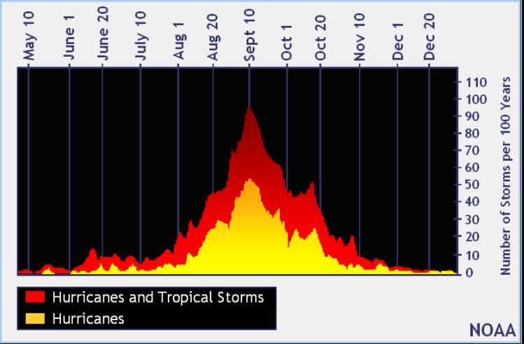
The peak of the season is Sept. 10, with the most activity happening between mid-August and mid-October, according to the Hurricane Center.
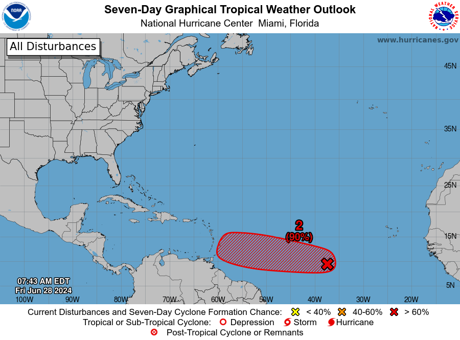
Tropical forecast over the next seven days
Excessive rainfall forecast
What's out there?
Systems currently being monitored by the National Hurricane Center.

Noaa
Embedded content: https://www.nhc.noaa.gov/xgtwo/two_atl_0d0.png?052051
What's next?
We will continue to update our tropical weather coverage daily. Download your local site's app to ensure you're always connected to the news. And look at our special subscription offers here.
This article originally appeared on Treasure Coast Newspapers: Hurricane Lee strengthening. See spaghetti models, forecast path. Cat 5

