Hurricane Lee forecast to make turn Wednesday, brush Bermuda

SAN JUAN, Puerto Rico (WFLA) — Hurricane Lee whipped up waves of more than 15 feet as the Category 3 storm cranked through open waters just north of the Caribbean region.
The storm is not expected to make landfall this week, although forecasters said residents of New England and nearby areas should keep a close eye on Lee, which was predicted to slowly turn northward later in the coming days.
National Hurricane Center watching 2 hurricanes and 1 disturbance with 80% chance of formation
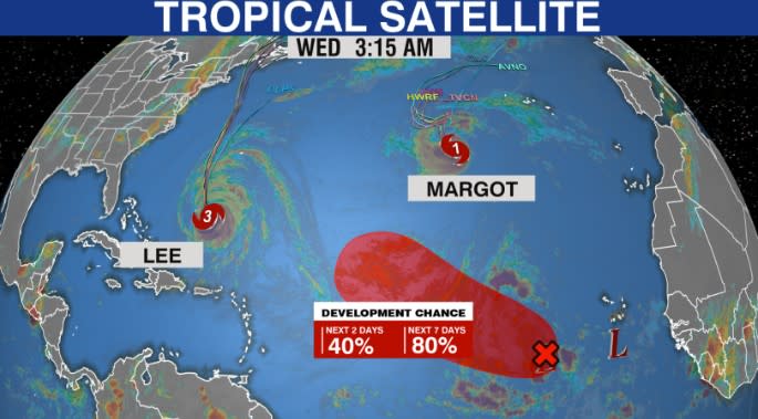
The storm was located about 430 miles south-southwest of Bermuda, according to the National Hurricane Center. It had maximum sustained winds of 115 mph and was moving northwest at 9 mph.
A tropical storm warning is in effect for Bermuda. A turn toward the north-northwest is expected later Wednesday. The center said Lee is likely to pass just west of Bermuda on Thursday and Thursday night and be located offshore of the mid-Atlantic states and New England by the end of the week.
“Although Lee is expected to weaken later in the week, it is expected to significantly increase in size, and hazards will extend well away from the storm center,” the agency said.
Bermuda could experience wind, rain and high surf, but “it is too soon to determine the specific timing and level of those impacts,” the center said.
A high surf advisory was in effect for Puerto Rico and the U.S. Virgin Islands, with the National Weather Service warning of breaking waves of up to 15 feet for north and east-facing beaches.
The National Hurricane Center also warned of dangerous surf and rip currents for most of the U.S. East Coast this week, but what the hurricane might do beyond that is unclear.
“It remains too soon to know what level of additional impacts Lee might have along the northeast U.S. coast and Atlantic Canada late this week and this weekend, however, wind and rainfall hazards will likely extend well away from the center as Lee grows in size,” the center said.
Lee strengthened from a Category 1 storm to Category 5 last week in the span of 24 hours before weakening slightly.
Lee is the 12th named storm of the Atlantic hurricane season, which runs from June 1 to Nov. 30 and peaked on Sunday.
In August, the National Ocean and Atmospheric Administration updated its forecast and doubled the chance to 60% for an above-normal hurricane system. Between 14 and 21 named storms are forecast, with six to 11 predicted to strengthen into hurricanes. Of those, two to five are forecast to become major hurricanes — storms that are in Categories 3, 4 or 5.
Hurricane Margot
Hurricane Margot is located about 790 miles west-southwest of the Azores. The storm is moving toward the north near 12 mph.
Forecasters said Margot is expected to turn to the north-northwest early Thursday. The storm will likely stall or meander within weak steering currents into the weekend, the NHC said.
Margot’s maximum sustained winds are near 85 mph, with higher gusts.
Swells generated by Margot will begin to affect the Azores later Wednesday. The swells are likely to cause life-threatening surf and rip current conditions.
Area of interest
Meteorologists are also monitoring a disturbance in the eastern tropical Atlantic. A broad area of low pressure continues to produce some disorganized showers and thunderstorms, the NHC said.
Forecasters said the system is likely to become a tropical depression over the weekend as it nears the central tropical Atlantic.
It has a 40 percent chance of formation over the next two days and an 80 percent chance of formation over the next seven days.
The Associated Press contributed to this report.
For the latest news, weather, sports, and streaming video, head to WKRN News 2.

