Hurricane Lee live updates: Millions in New England under storm warnings as landfall looms
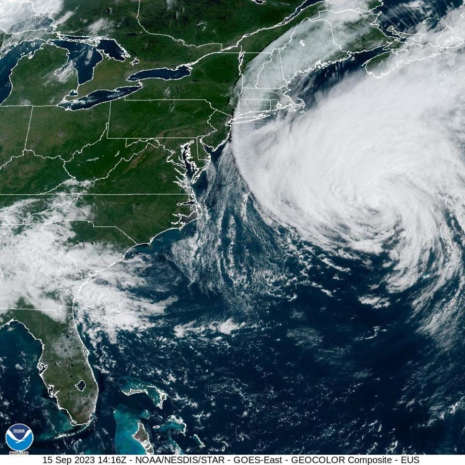
HAMPTON, N.H. — Millions of residents across eastern New England and parts of Canada remained under tropical storm warnings Friday evening as Hurricane Lee moved faster toward the region as a Category 1 hurricane with maximum sustained winds of 80 mph, according to the National Hurricane Center's evening update.
Due to the approaching storm, President Joe Biden granted a disaster declaration requested by Maine Gov. Janet Mills to ensure access to federal resources and personnel, officials said Friday. Mills already declared a state of emergency for the state.
There were widespread worries of power outages in Maine, the nation’s most heavily forested state, where the ground is saturated and trees are weakened from heavy summer rain. Utility workers from as far away as Tennessee began taking up positions Friday across the state as the storm approached.
Although Lee is not the storm it once was and the worst-case scenarios for landfall in the heart of New England are off the table, risks remain for residents along the coast, where the possibility of tropical-storm force winds is highest.
Lee was once a powerhouse Category 5
Once a powerhouse that doubled its wind speeds in 24 hours, growing to a Category 5 hurricane, Lee is now far weaker but much wider. The storm is encountering wind shear and dry air on its southern side that will continue to weaken the storm as it moves over cooler waters tonight and tomorrow, and Lee is forecast to be a tropical storm by Saturday evening.
But the extent of its tropical storm force winds – spanning a distance of 564 miles – remain a reason to take the storm seriously, the National Weather Service is warning the region’s residents. Wind gusts of up to 40-50 mph are possible inland, which is expected to bring down trees and damage power lines.
Because it's losing its pure tropical storm characteristics, its will seem more like a nor'easter, according to the weather service office in Portland, Maine.
Where is Lee now?
Lee was spinning about 290 miles south-southeast of Nantucket, Massachusetts, according to the National Hurricane Center's 5 p.m. advisory. It was traveling north on a path that could lead to landfall in Nova Scotia, possibly as a tropical storm, forecasters said.
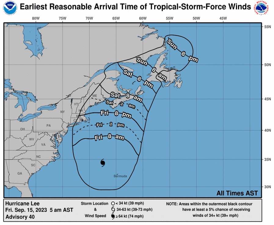
"The worst conditions on Cape Cod will occur late Friday night and Saturday as Lee tracks more than 100 miles to the east Saturday morning," AccuWeather hurricane expert Dan Kottlowski said.
Then, on Saturday, "hurricane conditions and coastal flooding are possible in portions of eastern Maine, southern New Brunswick, and western Nova Scotia," the National Hurricane Center said.
Maine prepares for Lee's arrival
Maine residents were preparing Friday for the arrival of Lee. "We've taken everything out of our yard that could blow around. We've taken things out of the windows," said Mollie Brunetti, 76, of Belmont, Maine. "We just took family pictures and put them in totes, and fragile things that could blow around."
"We've got our sump pumps set up and ready to go and if the power goes out, we'd have to hook that to a small generator we have. We're just doing the best we can," she added.
Elsewhere, in Bangor, Maine, the Lowe's Home Improvement store has seen a steady flow of customers purchasing generators, sump pumps, shop vacuums, water, flashlight and batteries, store manager Ryan O'Donnell told USA TODAY Friday afternoon.
"We're not used to this in northern Maine," he said. "There's a lot of chatter about that and hurricane weather, we don't hear a lot about that."
The store ended it's patio season and is taking advantage of the empty space to put it's hurricane prep supplies for customer's ease of access.
O'Donnell reiterated the anomaly of the hurricane, with Maine seeing high wind, intense rain and snow through the year, but rarely a hurricane.
"This is all new to the community in Bangor," O'Donnell said.
New storm forms in the Atlantic
Tropical Depression 15 formed Friday morning in the open Atlantic Ocean, and it's forecast to become major Hurricane Nigel within the next few days, the National Hurricane Center said. Although it's expected to stay out at sea and not affect any land areas, the storm will add to what is shaping up to be a very active 2023 Atlantic hurricane season.
"Through September 13, the 2023 Atlantic hurricane season is above average for all tropical cyclone parameters that we track at Colorado State University," tweeted hurricane researcher Phil Klotzbach this week. This includes named storms, named storm days, major hurricanes and major hurricane days.
See photos of hurricane prep: Hurricane Lee's path puts New England coastal towns on alert
How big is Hurricane Lee
Lee had a diameter of tropical-storm-force winds or higher across 564 miles on Friday, with winds of hurricane force spanning 184 miles. The tropical wind field is larger than the equivalent of 15 Rhode Islands if measured from east to west, and larger than three Massachusetts – again measuring east to west.
Comparing the size of Hurricane Lee to Hurricane Katrina
Strictly by size alone, Hurricane Lee is huge. On Friday, its wind field was much wider than that of infamous Hurricane Katrina at landfall. That's in part because Lee was already transitioning away from a purely tropical system.
Hurricane Katrina's tropical-storm-force winds hours before landfall were estimated at a diameter of 420 miles, while its hurricane-force winds spanned 178 miles.
Lee's hurricane-force winds span a similar diameter, 184 miles, but its tropical-storm-force winds extend more than 120 miles wider, a total of 564 miles.
Hurricane Katrina's winds, however, far dwarfed Lee's in intensity. At landfall, Katrina's maximum sustained winds were 120 mph, according to the hurricane center's final report. Lee's sustained hurricane force winds on Friday were 80 mph.
How is the size of a hurricane measured?
It's easy to roughly guesstimate the size of a hurricane using forecasts and satellites, but experts use a more exact method to calculate the size of the wind fields within the storm.
The size of the wind field in each quadrant of the storm is spelled out in each of the hurricane center's forecast advisories.
Wind fields are fluid and can shift and move depending on what's happening within the storm and how close it is to land, where there's greater friction than over the water.
"It's complicated," said Daniel Chavas, an associate professor of atmospheric science at Purdue University who has spent much of his career so far working on wind size. "It's so complicated, that there's no defined list" of hurricanes by size, Chavas said.
The National Oceanic and Atmospheric Administration has easily accessible lists that compare hurricanes by wind speeds and barometric pressure, but not size.

Martha's Vineyard bracing for wind, floods
Businesses on the popular Martha's Vineyard in Massachusetts are setting up sandbags and hoping for a best-case scenario ahead of the hurricane's expected impact, said Carolina Cooney, executive director of the Martha's Vineyard Chamber of Commerce.
As of late Friday morning, Cooney said it has been windy on the island as Dukes County has sent out a litany of emergency management information to businesses urging them to have emergency kits, batteries, dock boats and be prepared for possible power outages.
People are crossing their fingers in hopes that fears about the storm don't materialize and they don't sustain major damage. Cooney said some businesses are looking to close early Friday in anticipation of extreme winds and foods.
"It's only supposed to be tonight and tomorrow," she said. "The ferries are still running and some of us enjoy the wild weather."
Maine under state of emergency
Maine Gov. Janet Mills on Thursday declared a state of emergency as the state was under its first hurricane watch in 15 years Thursday afternoon. Earlier in the week, the region saw 10 inches of rain over six hours.
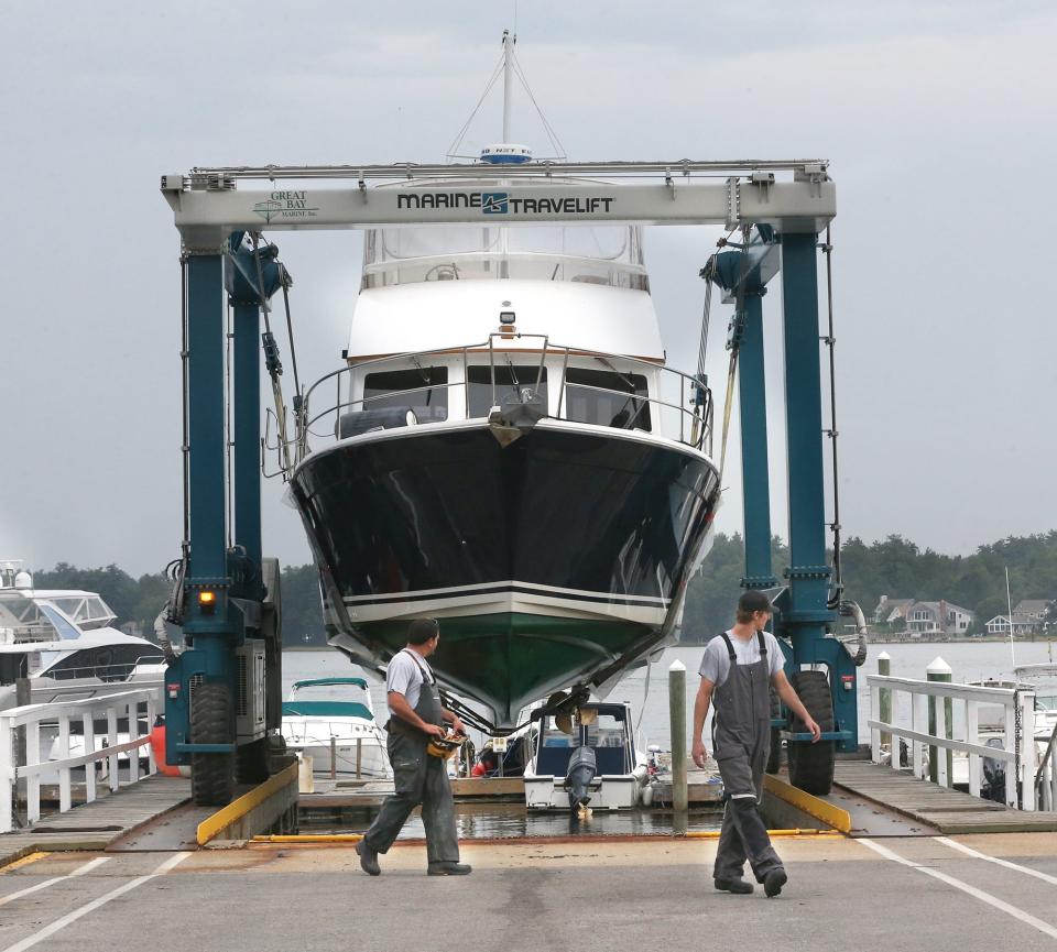
The Coast Guard and emergency management agencies warned New England residents to be prepared, and utility companies brought in reinforcements to deal with power outages. At Boothbay Harbor Marina in Maine, the community came together to remove boats from the water to keep them out of harm’s way.
“It’s a batten-down-the-hatches kind of day,” owner Kim Gillies said Thursday.
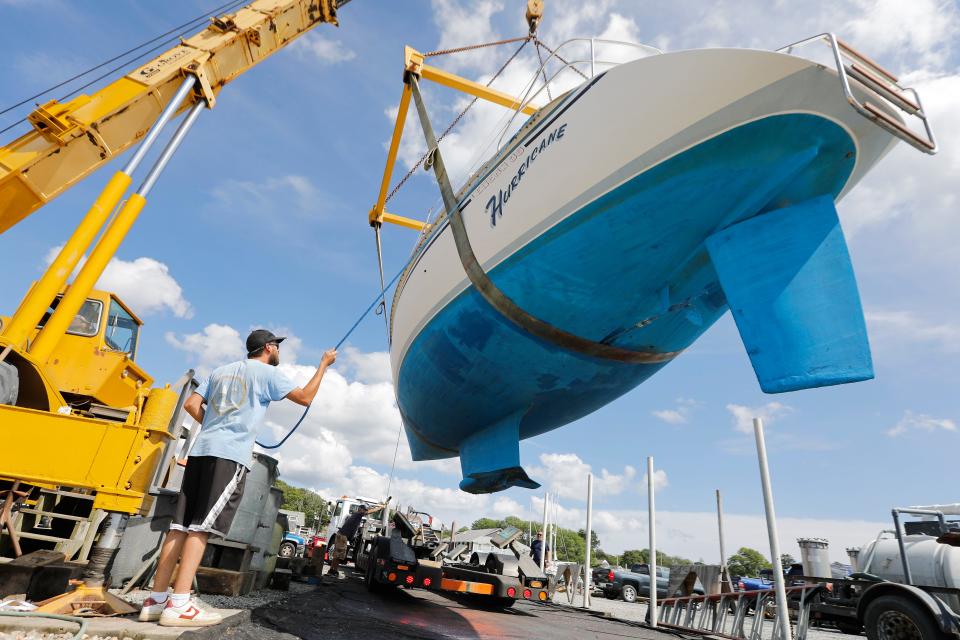
Commercial lobster fisherman Steve Train said fishermen have been sinking gear in deeper water to protect against storm damage. Fishing boats were also headed to the safety of harbors.
The system threatened to bring a mixed bag of threats to coastal Maine. Ocean waves as tall as 20 feet could lash the coast, damaging structures and causing erosion; powerful wind gusts could knock down trees weakened by a wet summer; and rain could cause flash flooding in a region where the soil is already saturated, said Louise Fode, a National Weather Service meteorologist in Maine.
State of Emergency declared in Massachusetts
Gov. Maura Healey declared a State of Emergency in Massachusetts on Friday and requested FEMA issue a pre-disaster emergency declaration, she announced during a noon press conference.
Healey activated 50 National Guard troops for storm preparation and to be prepared to respond with high-water vehicles if needed.
The Massachusetts Emergency Management Agency (MEMA) opened their state of emergency operation center at their Framingham headquarters at 7 a.m. The state will also set up operation centers in Franklin and Tewksbury to support local and state agencies.
The Massachusetts Department of Transportation told residents to plan ahead and to stay off the roads in the height of the storm.
Will Hurricane Lee impact Boston?
The worst of Hurricane Lee is expected to miss Boston, the state's largest city; however, nor’easter conditions with heavy rain, strong winds and flooding along coastal and low-lying areas were still expected through the weekend, Boston Mayor Michelle Wu said at a news conference Thursday morning.
She was made hopeful by the storm's turn "slightly east," according to the National Weather Service's Thursday update. She added that the hurricane's track could still change.
"At this time we are expecting the worst of it to miss Boston, which is good news," Wu said. "Fingers crossed that that will remain the projection."
Flight delays at Logan Airport in Boston and T.F. Green in Providence
As of Friday morning, both major airports are showing limited delays and cancelations for Friday night and Saturday morning flights. Cape Air has canceled Friday flights from Boston Logan International Airport to Bar Harbor, Maine.
The message on Logan’s website says advises travelers to check with their airlines for flight status prior to arrival at the airport.

Massachusetts official: 'The ground is saturated'
Officials across the state are also worried that the summer's heavy rainfall may worsen the storm's impact. Some parts of the Massachusetts South Shore received roughly double the amount of summer rain compared to last year.
“The ground is saturated,” said Peter Buttkus, the public works director of Duxbury. “... the trees act like sails.”
Derek Brindisi, the town manager of Plymouth, said, “We definitely anticipate losing trees during a high-wind event because the grounds are so saturated and roots become more susceptible to damage."
Cape Cod residents brace for Hurricane Lee
On Cape Cod, residents were advised to have cash on hand, a stock of non-perishable food, water and medicine for three days, flashlights and batteries, an emergency evacuation plan and a list of emergency contacts. The local power company, Eversource, said "Prepare for losing power for days."
Ace Hardware Store Manager James MacNaught in South Yarmouth, Mass., said Wednesday the store is selling sandbags, Quick Dam flood barriers, generators and TruFuel, plastic gasoline containers, chain saws, flashlights, batteries and coolers.
"We're seeing a lot of people," MacNaught said. "There's definitely an uptick."
'Not a lot of panic buying'
Joshua Allen, store manager of Trucchi's in New Bedford, Massachusetts, told USA TODAY he hasn't seen a lot of panic buying at the store. Traffic has been higher than usual, he said, but not it's not translating to sell-out items like what is seen in the winter with snowstorms.
"There's not a lot of panic buying going on and people I see on the weekend are coming in on today," Allen said.
His co-workers are in high spirits as well and he's only heard a few employees talk about leaving early Friday to beat any rain.
But Allen, who lives down the street from the store, said his concern is power outages as he'll need to be at the store if one happens.
Surfers in New Hampshire take advantage of waves ahead of Lee's arrival
As Hurricane Lee churns in the Atlantic, New Hampshire’s Seacoast is seeing large waves that are attracting surfers looking for a late-summer thrill.
Local surf photographer and blogger Ralph Fatello was at the surf spot known as Fox Hill in Rye Thursday, shooting pictures and video of surfers enjoying 10-foot waves in 60-degree water.

“It’s like surfing in Hawaii,” Fatello said. “We don’t get that that often.”
Surf shop Cinnamon Rainbows' Dave Cropper said the pleasant surfing conditions will last until Saturday when the storm worsens. He said the beach has been busy this week, as has his shop on Route 1 in North Hampton.
“Any time you have surf multiple days on end, that gets the crowds out,” Cropper said.
Contributing: Dinah Voyles Pulver; Caitlyn Kelleher, USA TODAY Network; Hannah Morse, The Patriot Ledger; Denise Coffey, The Cape Cod Times; Cheryl McCloud; Kinga Brody, Worcester-Telegram; Associated Press.
This article originally appeared on USA TODAY: Hurricane Lee live updates: New England residents brace for landfall

