'Dangerous hurricane' Lee weakens slightly Saturday but is forecast to re-strengthen
Read the latest Hurricane Lee updates Saturday: Will Hurricane Lee turn and miss the East Coast?. Previous coverage below:
⋯
Hurricane Lee weakened some Saturday, but the storm churning in the Atlantic Ocean is expected to strengthen again. Forecasters are still evaluating risk to land, including the United States' East Coast.
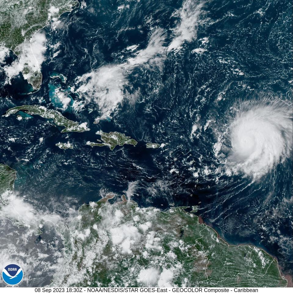
Hundreds of miles from land, the storm ‒ once a Category 5 hurricane – was a Category 3 storm on Saturday morning with winds of 115 mph.
"Regardless of the details, it is likely that Lee will continue to be a dangerous hurricane through the entire forecast period," a Saturday discussion from the National Hurricane Center says.
The National Hurricane Center's five-day forecast indicates Lee will continue moving west-northwestward on a track that takes it somewhere northeast of the Turks and Caicos Islands and the eastern Bahamas on Tuesday, Michael Brennan, the center's director, said Friday.
High surf and life-threatening rip currents are are expected to affect the islands in the northeastern Caribbean through the weekend.
Most computer models used by the hurricane center agree that Lee will make a turn to the north that will spare Florida from a potential landfalling hurricane.
"There’s absolutely no indication in front of us that this is going to be a huge threat to Florida, other than it’s going to be a huge rip current risk," Jamie Rhome, the center's deputy director, told USA TODAY on Friday.
"Right now, save the rip current risk, which is extreme, there’s no reason for people on the East Coast to be fearful," Rhome said. "We need them to be informed and aware and check back for details but right now there’s no reason other than rip currents for people to be fearful."
Rough surf, rip currents and hazardous conditions are forecast along much of the U.S. East Coast starting as early as Sunday evening. By Tuesday and Wednesday, a large field of very large waves will reach the U.S. East Coast, "producing dangerous surf, rip current conditions and certainly some beach erosion," Brennan said.
As for direct impacts farther to the north, along the Northeast U.S. or Canadian coasts, large margins of error remain in forecasts that far out, the center has said.
“Right now, every computer model is showing there’s a big dip in the jet stream over the United States that seems very likely,” said David Nolan, a professor of atmospheric science at the University of Miami’s Rosenstiel School and its Cooperative Institute for Marine and Atmospheric Studies. “If that depiction comes through, what’s going to happen is Lee’s going to basically be pulled up.”
But it's still too soon to know for sure what the impacts will be to the U.S. East Coast and Canada by late next week, said Nolan, echoing guidance in the hurricane center's forecast discussions.
Where is Hurricane Lee?
At 5 a.m. Saturday, Lee was 385 miles east of the northern Leeward Islands, moving west-northwest at 12 mph, the National Hurricane Center said.
FEMA prepares for potential impacts from Lee
President Joe Biden on Thursday was given the hurricane’s latest trajectory and details of preparations underway by the Federal Emergency Management Agency. About 4.5 million meals and nearly 8.9 million liters of water are available in Puerto Rico, and another roughly 250,000 meals and more than 600,000 liters of water in the U.S. Virgin Islands, the agency said Friday.
FEMA said it has also deployed rapid response teams to both U.S. territories as a precaution.
Hurricane center's forecast track for Lee
The official forecast track cone shows the most likely path of the center of the storm. It does not illustrate the full width of the storm or its potential impacts, and the center of the storm is likely to travel outside the cone up to 33% of the time.
Expect hazardous beach conditions
Conditions will be hazardous at the beach regardless of Lee's distance from shore, Brennan said. Even if it's "well offshore and well away from the U.S. East Coast," a hurricane can produce dangerous surf and rip current conditions and beach erosion, he said, "even when otherwise it's a very nice day to be at the beach."
AccuWeather senior meteorologist Alyson Hoegg said Friday that the rip currents and rough surf could be "life-threatening" for people who venture into the water.
Deaths among people who go into the surf during hurricanes have increased in recent years, according to the National Oceanic and Atmospheric Administration.
"So you always want to pay attention to the latest beach forecast, pay attention to any warning flags that are flying or advice given by lifeguards," Brennan said.
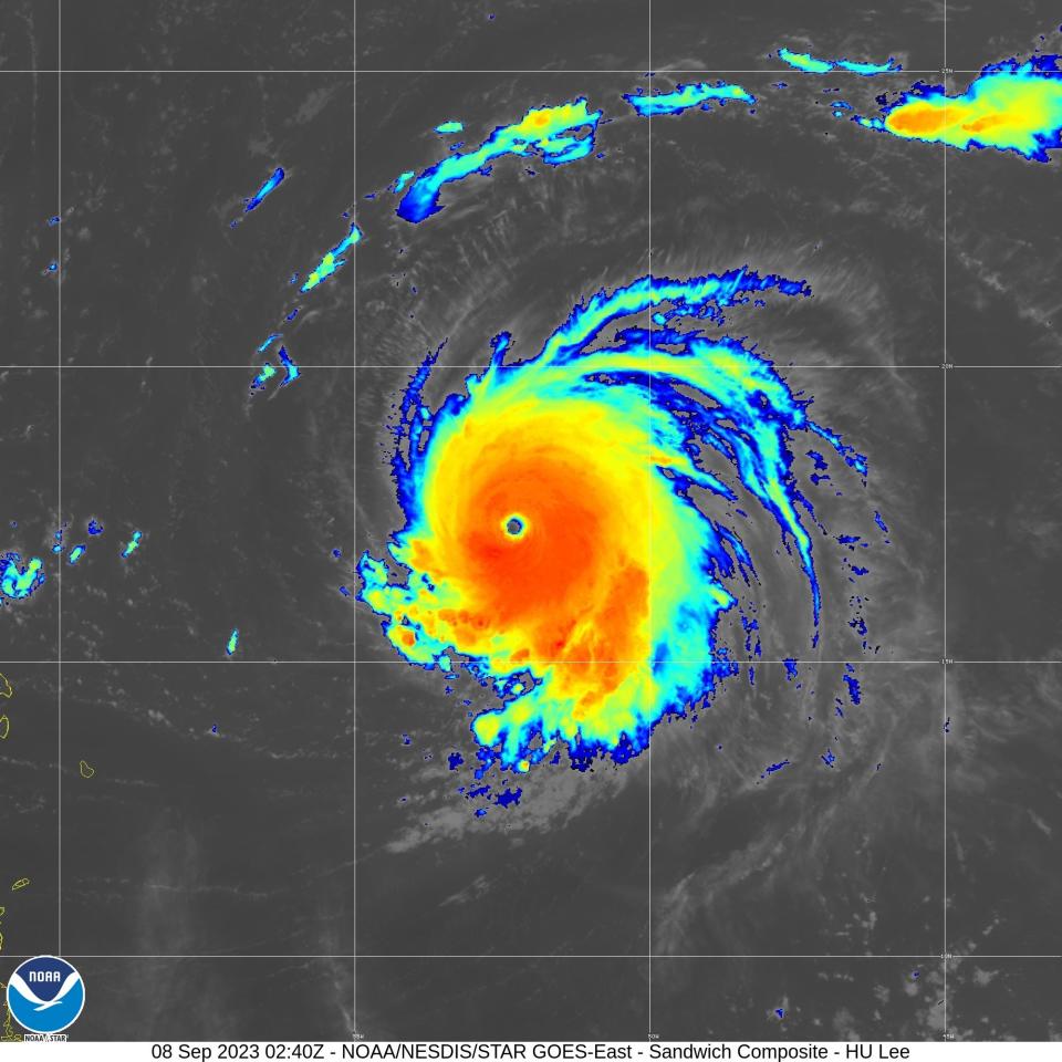
Why did Lee rapidly intensify?
"This is one of the most impressive rapid intensification episodes I've ever seen in the Atlantic," meteorologist Levi Cowan, founder of tropicaltidbits.com, wrote Thursday on X, formerly Twitter. Hurricane Lee went from having no eye in the morning to a Category 5 by the evening. "Absolutely incredible," Cowan said.
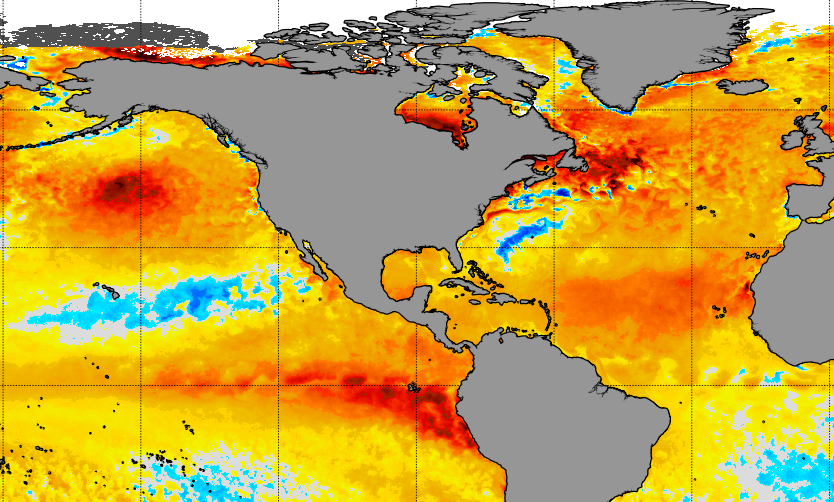
Water temperatures in a swath across the Atlantic are much warmer than normal, averaging nearly 85 degrees, the hurricane center said.
"But it's not just the sea surface temperatures," said Mark Bourassa, a meteorology professor at Florida State University − it's that Lee was in a place where nothing else was interfering with it strengthening to the degree the sea surface temperatures would support.
Storms intensify when there's nothing else messing them up, Bourassa said. "Lee is not near land, there's no dry air coming in, and there's no higher winds aloft."
How does Lee compare with other hurricanes?
Despite its strengthening from Category 1 to Category 5 status in 24 hours on Thursday, Lee isn't the fastest storm to intensify in the Atlantic. In October 2005, Wilma rocketed from a tropical storm to a Category 5 hurricane in 24 hours, according to the hurricane center's post-storm report.
Five other Atlantic storms have intensified by 80 mph or more in 24 hours, Philip Klotzbach, a hurricane researcher at Colorado State University, posted on X Thursday night. They are: Wilma (2005), Felix (2007), Ike (2008), Matthew (2016), Maria (2017) and Eta (2020).
Klotzbach also shared the list of other hurricanes that have had winds equal to or greater than 180 mph. They are: Allen (1980), Gilbert (1988), Mitch (1998), Rita (2005), Wilma (2005), Irma (2017) and Dorian (2019).
What the spaghetti model plots show
Model plot illustrations include an array of forecast tools and models, and not all are created equal. The hurricane center uses the top four or five highest-performing models to help make its forecasts.
Other storms the hurricane center is watching:
Margot – The season's 13th named storm – formed in the Atlantic Thursday. About 890 miles west-northwest of the Cabo Verde Islands, it was forecast to become a hurricane on Sunday as it moves north in the Atlantic far from land.
Jova – In the Pacific, after intensifying this week, Hurricane Jova was forecast to move into cooler water and dissipate by early next week.
How do hurricanes form? An inside look at the birth and power of ferocious storms
Contributing: The Associated Press
This article originally appeared on USA TODAY: Hurricane Lee updates: Now category 3, NHC forecasts strengthening

