Hurricane Lee’s rain bands approach New England; Tropical Depression 15 forecast to become major hurricane
Hurricane Lee’s outer rain bands reached New England as the large storm continued its track to the north, with tropical storm and hurricane conditions expected to begin Friday and last throughout the weekend.
Though the storm was far away from Florida, swells generated by Lee were creating a high risk of life-threatening rip currents in Palm Beach County, forecasters said, likely to remain through the weekend and into early next week.
Meanwhile, Tropical Depression 15 formed in the Central Atlantic and expected to become a major hurricane as it approaches Bermuda.
Lee will remain “large and dangerous” for the next few days; it was maintaining Category 1 storm strength Friday with sustained wind speeds of 80 mph. The storm continues to arc northward, accelerating on a trajectory that will carry it along the eastern seaboard of the United States.
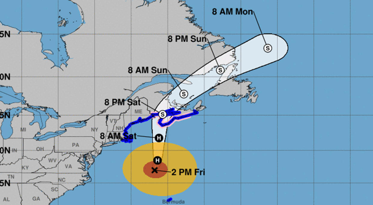
As of 5 p.m. Eastern time Friday, Hurricane Lee was located about 290 miles south-southeast of Nantucket, Massachusetts, heading north at 20 mph.
Though Lee is expected to start gradually weakening Friday night, the storm will remain large and powerful, forecasters said. Its hurricane-force winds extend out 115 miles and tropical-storm-force winds extend out 345 miles.
“Little change in strength is expected through tonight. Lee is forecast to become post-tropical and begin weakening by Saturday, but it is still expected to be a large and dangerous storm when it reaches eastern New England and Atlantic Canada,” forecasters said.
Tropical storm conditions are forecast to begin in southern New England on Friday afternoon with hurricane conditions in Maine and Canada on Saturday as the storm picks up speed and transitions as it moves over colder waters. The hurricane center warns conditions could lead to downed trees and power outages. Some urban and small stream flooding is possible from the forecast 1 to 4 inches of rain. Storm surge is expected to rise 1 to 3 feet in some areas.
A hurricane watch is in place for the coast of northern Maine to the Canadian border, and most of coastal New England is under a tropical storm warning, including Martha’s Vineyard and Nantucket, up to the Canadian border. Several areas of southeastern Atlantic Canada are under a tropical storm watch.
Storm surge could reach up to 3 feet in Cape Cod, Long Island Sound, Martha’s Vineyard and Nantucket, Boston Harbor, and from Flushing, New York, to the Canadian border, forecasters said.
“Life-threatening surf and rip current conditions” were expected to move north along much of the coast and to Atlantic Canada in the next few days, the hurricane center said. Swells were already reaching the eastern U.S., Canada and several islands in the Caribbean.
There may be a higher risk of rip currents at Atlantic Coast beaches through the weekend due to a swell developing as Lee moves north, the National Weather Service Miami said. Palm Beach County beaches are at the highest risk.
Lee will be traversing much cooler sea-surface temperatures by Friday night, which will begin to weaken the storm, forecasters said.
“Regardless of Lee’s designation when it approaches New England and Atlantic Canada, it will remain a very large and dangerous cyclone through landfall,” forecasters said.
A new tropical depression formed in the central Atlantic on Friday morning, expected to become a hurricane northeast of the Lesser Antilles in the far-eastern Caribbean as it moves northwest at 13 mph.
It should intensify more rapidly over the weekend, becoming a storm on Saturday, then a hurricane later this weekend, forecasters said.
If it forms, it will be Tropical Storm Nigel. The storm is forecast to become a major hurricane as it approaches Bermuda, with top winds reaching of 120 mph, according to the National Hurricane Center.
Far to the east, a weakening Tropical Storm Margot continued making a slow loop in the north-central Atlantic. Its top winds remained at 65 mph as of late Friday afternoon. It was located about 615 miles west of the Azores, moving southeast at 3 mph, and is likely to downgrade to a tropical depression.
The hurricane center is also tracking one other system off the coast of Africa.
A tropical wave is forecast to emerge off the west coast of Africa by the middle of next week. Forecasters are giving the system a 20% chance to form in the next seven days.
The season officially runs through Nov. 30.
_____

