What happens when hurricanes rapidly intensify and how is that affecting Cat 4 Lee?
In just a few short days, Lee went from a small tropical storm to a Category 2 hurricane to the top of the chart: a powerful Category 5 hurricane.
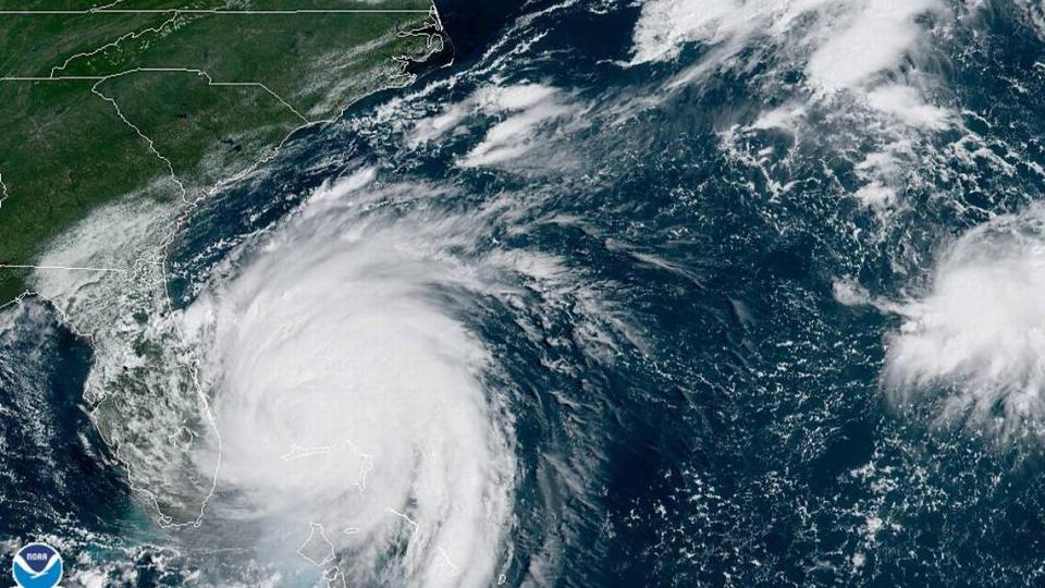
On satellite, Lee’s already formidable winds had started to wrap around a visible eye at the center, and the road ahead appeared to be paved with record-warm waters and otherwise friendly conditions for a strong storm.
Megan Borowski, senior meteorologist for the Florida Public Radio Emergency Network, called the conditions “good, if not great” for strengthening.
“On satellite, you can see it’s got a well-formed eye and high cloud tops. That all tells me that we’ve got a strong hurricane,” she said.
Thankfully, long-range forecast models appear to point Lee north and away from the East Coast of the U.S., although forecasters warn that residents should still keep an eye on the forecast — just in case.
But as of Friday, Lee was nearly 600 miles away from the nearest inhabited piece of land, the Leeward Islands. The open ocean ahead of it is warmer than it’s ever been, forming a solid source of fuel for Lee to suck up and turn into the billowing storm clouds that wrap around its now sharply defined eye.
The National Hurricane Center predicted Friday that Lee could maintain Category 4 hurricane status for the next few days, a drop from its peak as a Category 5 overnight. Its biggest jump so far was on Thursday, when it jumped from 110 mph to 160 mph in a single day. Gaining that much power in such a short time is called rapid intensification, and it happens in nearly all “major” Category 4 and 5 storms.
“The question doesn’t appear to be if [rapid intensification] continues, but rather how strong Lee will get, and how quickly will it get there. Many of the models are calling for remarkable rates of intensification, beyond rates normally seen with model forecasts,” the National Hurricane Center wrote in the 11 a.m. Thursday discussion.
The ingredients for rapid intensification
Kim Wood, an associate professor of hydrology and atmospheric sciences at the University of Arizona, said hurricanes rely on a set of ingredients both externally and internally to get stronger.
“When it comes to rapid intensification there’s two sets of ingredients we care about. One set is in the environment, and one set is in the storm itself,” they said.
The external ones are easy to spot and relatively straightforward to understand. Storms run off of moisture, so warm oceans — both on the surface and deeper below — plus moist air are easy fuel for storms.
Storms also prefer when the center eye can stay straight up and down as it moves across the ocean. When winds near the surface of the ocean are headed in one direction and the winds miles in the air are blowing another, that tilts a storm and makes it harder to organize and strengthen. That difference in wind direction is called shear, and there’s not much of it ahead of Lee right now.
And the waters ahead are warm, not just on the surface but for several feet underneath. That means when a storm starts churning up the ocean and absorbing that moisture, there’s even more fuel to gobble up.
The Atlantic basin is far warmer than it’s been in past decades, both as a result of the annual weather phenomena known as El Niño and the long-term impacts of human-caused climate change.
“The tropical Atlantic in 2023 looks like the Gulf of Mexico in 1983. Even compare it to 1998 — a very warm year for the 1990s and very warm for any year up to that point. The Atlantic blows it away in 2023,” Eric Blake, a senior hurricane scientist at the National Hurricane Center posted on X, the social media site formerly known as Twitter.
The tropical Atlantic in 2023 looks like the Gulf of Mexico in 1983. Even compare it to 1998- a very warm year for the 1990s and very warm for any year up to that point. The Atlantic blows it away in 2023. pic.twitter.com/0W4GwVMxh7
— Eric Blake (@EricBlake12) September 6, 2023
Blake, whose social media posts are not statements from his employer, went on to say that the waters Lee is entering now are about 2 degrees warmer than they were in 1983, an “astounding difference” that he said “arguably doubles or triples the chance of rapid intensification.”
Multiple scientific studies suggest that climate change has made rapid intensification more likely, and a warmer planet is more likely to have hotter oceans and less wind shear, the crucial ingredients to make it happen.
READ MORE: What we know — and don’t — about how climate change impacts hurricanes
Looking under Lee’s hood
The other set of ingredients to make a storm rapidly intensify are harder to spot because they happen inside a storm.
Wood describes it like a car getting from point A to point B. The road ahead matters. Is there traffic? Is the road paved or dirt? Those factors, like a hot ocean or wind shear, are easy to spot.
“We can see that from far away. To look under the hood you’ve got to be much closer,” they said. “But looking inside the storm is harder and thus forecasting what the storm will do is harder.”
Scientists can take a peek inside a storm through different satellite images and through the work of the Hurricane Hunters, planes of scientists that fly directly into storms to capture data and improve forecasts.
One of the first things forecasters are looking for is the shape of the storm. A more asymmetric storm can have a hard time pulling together, which can slow it down. A very round, organized storm can develop a smaller and smaller eye, which helps it intensify.
Tropical Storm #Lee has went full shrimp mode. pic.twitter.com/z2Bpg7OBZv
— Jamai Woodberry (@woodberrywx) September 6, 2023
The halfway point between disorganized lump and deadly circle is a spiral shape some meteorologists call a “shrimp.” The shrimp shape indicates that the storm is starting to suck in more thunderstorm clouds and wrap them around its eye. Once that eye is fully closed off, it can start seriously strengthening.
“One thing that struck me this morning was watching how quickly, over the space of hours, that shrimp structure turned into a very distinct eye surrounded by cold cloud tops. It went from ‘Oh, it’s trying to form an eye in satellite imagery’ to ‘OK, that’s an eye,’ ” Wood said.
The next thing forecasters watch for is called an eyewall replacement cycle, which is when a very powerful storm starts to lose its center eye and form a new, larger center farther out in the storm. That can lead to lower overall sustained wind speed as the storm readjusts, and sometimes it can emerge even stronger — but not always.
“The outcome of an eyewall replacement cycle is not set in stone. Sometimes a storm never returns to its initial intensity,” Wood said.

That’s exactly what the hurricane center is watching for with Lee over the next few days, and it’s one of the reasons a storm’s intensity can be hard to forecast.
“It should be stressed that internal dynamics [eyewall replacement cycles] will become a factor with the maximum strength of Lee as it becomes a major hurricane. This is almost certain to lead to fluctuations in intensity that are beyond our ability to forecast at these lead times,” the hurricane center wrote Thursday morning.
How Lee stacks up historically
At its peak, the hurricane center now forecasts Lee to pack maximum sustained winds of 155 mph, a Category 4 storm. There is no Category 6 for storms, because the definition of a Category 5 on the Saffir-Simpson wind speed scale is anything 157 mph or greater.
But if Lee stays in that powerful and rare range, it will still notch a few slots below some of the most powerful storms to ever slice through the Atlantic.
Topping the list is the Labor Day hurricane of 1935, which struck Florida and obliterated parts of the Florida Keys. It was a Category 5 with 185 mph sustained winds, the strongest storm to make landfall for many decades.
That is, until it was tied in 2019 by Category 5 Hurricane Dorian. It struck the Bahamas with 185 mph winds and up to 25 feet of storm surge, decimating swaths of the low-lying island chain.
South Florida’s most infamous storm, Hurricane Andrew in 1992, is remembered for the ferocity of its winds. But compared to Dorian and the Labor Day hurricane, its winds topped out at a mere 165 mph.

