Hurricane Lee reaches Category 4 strength in Atlantic Ocean. Will it hit Pensacola?
After Tropical Storm Lee formed into a hurricane Wednesday afternoon in the Atlantic Ocean, it quickly grew to a Category 4 storm Thursday night.
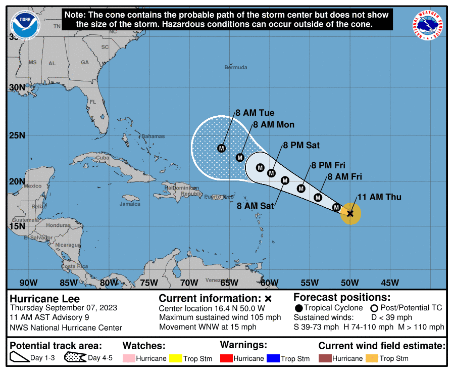
Hurricane Lee currently has maximum sustained winds of 135 mph, according to the National Hurricane Center. According to recent spaghetti models, Lee, the 12th named storm of the season, will likely curl eastward back toward the Atlantic, never hitting Florida and keeping Pensacola out of the crosshairs.
Despite a majority of spaghetti models forecasting Lee to curl back east, one model named XTRP, which uses an extrapolation of NHC data based on the storm's past 12-hour movement, tracks it heading straight for the Panhandle. However, spaghetti models differ from one another and can be difficult to determine which is "best" for forecasting.
Will it hit Cat 5?: 'Dangerous' Hurricane Lee spins in Atlantic: Will it reach Category 5 intensity of 157 mph?
National Weather Service in Mobile forecaster Morgan Barry told the News Journal that Lee is not expected to hit Pensacola.
"There is a very strong ridge of high pressure that is over the Atlantic, and that's what is going to cause the storm to eventually start to curve," Barry said. "It should not impact our area and it should stay out in the Atlantic. There is a lot of uncertainty about how close it will get to the east coast."
Lee expected to become at least a Category 4 hurricane
Lee is expected to undergo rapid intensification as it zooms across the Atlantic, thanks to unusually warm ocean water and a lack of wind shear, both of which act to strengthen storms. Forecasts from the hurricane center now predict the storm at 150 mph, a strong Category 4 hurricane, by the weekend.
AccuWeather said that the storm's winds would reach or surpass 157 mph, making it a Category 5 hurricane and the "most intense storm" of the 2023 Atlantic hurricane season.
Other private forecasters are also predicting that Lee could reach Category 5 intensity.
Where is Lee headed?
Lee is forecast to move northwest over the open Atlantic Ocean over the next few days and have only minimal impact on the islands of the Caribbean.
Beyond that, all major hurricane models that meteorologists use to forecast storms indicate that Lee will recurve away from Florida. Looking even further ahead, the latest forecasts suggest Lee's path could vary across a wide swath spanning from the U.S. East Coast northward to eastern Canada, or even skirt away from the coast entirely.
How is the 2023 Atlantic hurricane season stacking up?
Lee is the 12th named storm to form this season. It's the season's fourth hurricane and third major hurricane.
If Lee becomes a Category 4 hurricane by Saturday, it will be the third Category 4 storm this year, following Franklin and Idalia.
An average hurricane season produces 14 named storms and seven hurricanes. Even before the season started, forecasters said 2023 was likely to be a busier-than-normal season, but in August they bumped up their predictions, calling for 14-21 named storms.
Contributing: Cheryl McCloud and Doyle Rice, USA TODAY Network
This article originally appeared on Pensacola News Journal: Hurricane Lee strengthens, Pensacola clear of path

