Hurricane Lee slows ahead of northward turn as US East Coast remains an area of concern
Hurricane Lee has slowed down slightly ahead of its expected turn northward as it moves away from land, the latest forecast shows.
The storm, which intensified to a Category 3 storm again as it whirls across the open Atlantic Ocean, is expected to go through “additional strengthening” within the coming days.
Lee exploded to a Category 5 storm within 24 hours last week before slowing down and reorganizing over the weekend. Just behind Lee is Tropical Storm Margot, which is predicted to reach hurricane status by Monday afternoon.
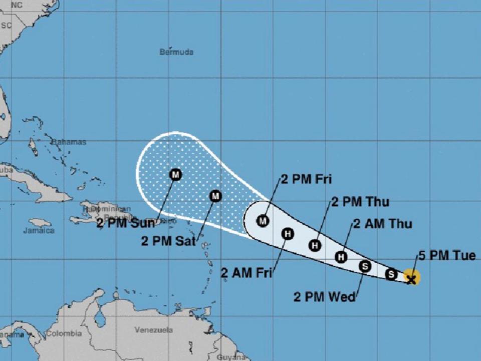
Hurricane Lee is moving well north of Puerto Rico, the Virgin Islands and the northern Leeward Islands, though it still remains too early to determine whether the northeastern US coast and Canada could see any impacts, according to advisories from the National Hurricane Center on Sunday.
Life-threatening surf and rip conditions are expected along the East Coast, while dangerous swells generated by the storm are spreading to the Virgin Islands, Puerto Rico, Hispaniola, the Turks and Caicos Islands, the Bahamas, and Bermuda.
Lee’s historic intensification from an 80 mph Category 1 to a Category 5 with 160 mph winds last week makes it one the fastest-intensifying Atlantic storms on record. Warm waters are a potent fuel for hurricanes to gain strength, a phenomenon expected to accelerate amid a growing climate crisis.
Key Points
Latest Lee update: Hurricane ‘restrengthening’ as Category 3 storm
Tropical Storm Margot predicted to turn into a hurricane on Monday
How Lee shattered ‘rapid intensification’ standards
Here’s how quickly the storm picked up speed
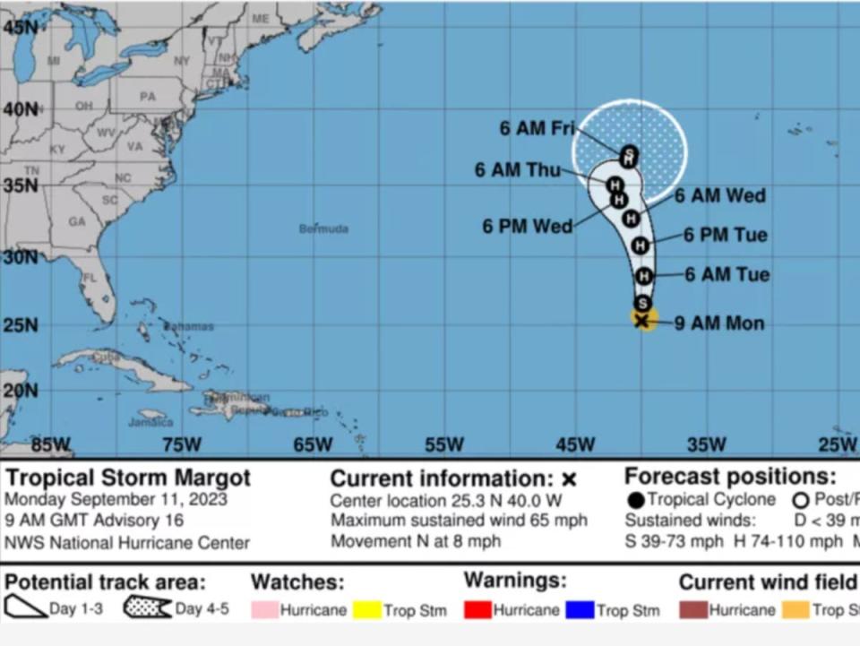
Path of Hurricane Margot
07:00 , Stuti Mishra
Margot which has strengthened into a hurricane now, is expected to continue to remain in open waters.
Here’s the path the storm is following:

Margot strengthens into a hurricane
06:24 , Stuti Mishra
Tropical Storm Margot intensified into a hurricane on Monday night with further strengthening forecast during the next 48 hours, the US National Hurricane Center said in its latest advisory.
The hurricane was located about 1,265 miles (2,035km) northwest of the Cape Verde Islands, packing maximum sustained winds of 75mph (120kph), the Miami-based forecaster said.Margot became a Category 1 storm Monday afternoon and was expected to continue to intensify to become the fifth hurricane of the season. It was forecast to remain over open waters.
Hurricane Lee’s late-week impact on US east coast, Canada, still unknown
04:59 , Graig Graziosi
Hurricane’s Lee’s potential late-week impact on the US east coast and Canada is still unknown, according to the National Hurricane Centre.
“It remains too soon to know what level of impacts, if any, Lee might have along the U.S. East Coast and Atlantic Canada late this week, especially since the hurricane is expected to slow down considerably over the southwestern Atlantic,” the centre said on Monday.
It did note, however, that high surf and rip currents were still likely along the coast.
Heavy rains and high surf possible risk for Bermuda this week
04:00 , Graig Graziosi
Hurricane Lee may bring heavy rains, strong winds, and high surf to Bermuda later this week as it continues its journey through the Atlantic basin and along the US east coast.
“Lee could bring wind, rainfall, and high surf impacts to Bermuda later this week. Although it is too soon to determine the specific timing and level of those impacts, interests on Bermuda should monitor the latest forecasts for Lee,” the National Hurricane Centre said in a report.
Hurricane Lee is expected to gradually shift north by the middle of the week.
We’re in the ‘peak’ of Atlantic hurricane season
03:00 , Alex Woodward
Sunday’s climatological peak of the Atlantic hurricane season – with conditions ripe for tropical storms and hurricanes – saw considerable action, with a strengthening Category 3 hurricane and soon-to-be hurricane tracking closely together, followed by two brewing systems to their west.
The “peak” date typically sees ocean waters at their highest temperatures, peak intensity in the atmosphere to generate thunderstorms, and shearing winds that can suffocate storms declining to a minimum, which tropical waves that fuel storms in the summer continue well into September.
What happens when hurricanes ‘collide’?
02:00 , Stuti Mishra
Tropical Storm Margot is expected to reach hurricane status on Monday, raising the prospect of two potentially major hurricanes spinning in the Atlantic simultaneously and in similar paths.
That phenomenon, when two storms rotate around each other and spin in the same direction, is called the Fujiwhara effect. The National Weather Service describes it as “an intense dance around their common center” and potentially combine into one major storm.
The rare phenomenon occured with hurricanes Hilary and Irwin in the East Pacific in 2017.
If one hurricane is stronger than the other, the smaller one will orbit it and eventually come crashing into its vortex to be absorbed, according to the NHC.
“Two storms closer in strength can gravitate towards each other until they reach a common point and merge, or merely spin each other around for a while before shooting off on their own paths,” the center explains.
Hurricane season, by the numbers
01:00 , Alex Woodward
NOAA forecasts 12 to 17 total named storms this year, with five to nine of those storms turning into hurricanes, including up to four major hurricanes with winds of 111 mph or higher.
The season, which officially began on 1 June and will end on 30 November, already has produced 14 storms, including four hurricanes – theree of which were Category 3 or higher.
Lee is the strongest yet among them.
Half of world’s population suffered under climate crisis-fuelled extreme heat this year, research says
Tuesday 12 September 2023 00:00 , Graig Graziosi
Nearly half of the world’s population was exposed to at least 30 days of extreme heat driven by the climate crisis between June and August, according to recently published research from Climate Central.
More than 3.8 billion people across the world suffered extreme temperatures for over a month, while “nearly every living human” – around 98 per cent of the world – was exposed to extreme heat at least once between June and August 2023, the report found.
The longest duration of extreme temperatures, approximately three months, was experienced by at least 1.5 billion people who were exposed to unusually high heat on each day over the period of June to August, the study says.
The Independent’s Stuti Mishra reports:

Half of world’s population suffered under extreme heat this summer, study says
Can Hurricane Lee become Category 5 again?
Monday 11 September 2023 23:00 , Graig Graziosi
Lee went through another phase of intensification over the warm Atlantic waters, returning to Category 4 strength after it was downgraded to Category 2 on Saturday.
The National Hurricane Center said the storm would intensify on Monday morning, though it failed to reach a Category 5 storm by Monday evening. Last week the storm went from Category 1 to Category 5 within 24 hours.
Hurricane Margot becomes fifth hurricane of the 20223 season
Monday 11 September 2023 22:50 , Graig Graziosi
The National Weather Service announced that Tropical Storm Margot had been upgraded to a full fledged hurricane on Monday afternoon.
Hurricane Margot is the fifth hurricane of the season, and formed not only during the peak of the season but in the immediate wake of Hurricane Lee, which is still churning through the Atlantic off the southeastern coast of the US.
Newly formed Hurricane #Margot becomes the fifth hurricane of the 2023 Atlantic Season. https://t.co/0bcEmBeFdb pic.twitter.com/Fc1hphwzr4
— National Weather Service (@NWS) September 11, 2023
New Englanders “need to be careful” as Hurricane Lee heads for the US east coast
Monday 11 September 2023 22:00 , Graig Graziosi
John Cangialosi, senior hurricane specialist at the National Hurricane Center, said that New Englanders “need to be careful” if they have any seafaring adventures planned in the coming days.
Hurricane Lee may move close to the US northeast coast, bringing with it high waves, dangerous rip currents, and strong winds.
Mr Cangialosi told Boston.com that mariners should keep up-to-date with their local weather services before setting out to sea, especially later in the week as the hurricane moves further north.
“If you’re going to go offshore, you need to be careful,” Mr Cangialosi said. “You need to go now or wait for this to go by.”
Despite the warnings, researchers have noted that its unclear exactly what effect Hurricane Lee will have on northeastern states by the time it reaches the area.
The storm is still gaining strength, but will likely weaken as it hits colder northern waters. Despite its weakening, the storm may still produce high winds within hundreds of miles of its centre.
Atlantic to see two simultaneous hurricanes as Margot strengthens
Monday 11 September 2023 21:00 , Stuti Mishra
Hurricane Lee is expected to continue to gain strength as it cruises across the Atlantic Ocean, and just behind it is Tropical Storm Margot, which forecasters predict will reach hurricane strength today.
Tropical Storm Margot became the 13th named storm after forming on Thursday evening, but it was far out in the Atlantic and posed no threat to land. It was last spotted about 1,185 miles (1,910 kilometres) west-northwest of the Cape Verde Islands late on Sunday night. Its winds stood at 65 mph (100 kph) and it was moving northward at 8 mph (13 kph).
It’s unclear what path they will take in the coming days, and whether they will pose a threat to the East Coast.
But they could get close enough for a phenomenon called the Fujiwhara effect, in which two storms rotate around each other and spin in the same direction. The National Weather Service describes it as “an intense dance around their common center.”
The phenomenon occured with hurricanes Hilary and Irwin in the East Pacific in 2017.
‘Rapid intensification’ of storms likely to accelerate with warming waters
Monday 11 September 2023 20:30 , Alex Woodward
Hurricane Lee is in rare company. Only two recorded storms – Hurricane Wilma in 2005 and Hurricane Felix in 2007 – strengthened faster than Lee over a 24-hour period, as Lee developed from a Cat 1 to a Cat 5 last week before degrading into its current Cat 3 status.
The storm is predicted to continue to regain strength after slowing down over the weekend.
Brian McNoldy with the University of Miami told NBC News that the warm conditions in the Atlantic were ripe for the storm’s rapid intensification last week.
The “vertical wind shear was very low and the water temperature under it was very warm,” he said, adding that Lee “took full advantage of both.”
Last year, Hurricane Ian rapidly intensified over two separate periods before striking Florida. Hurricane Idalia recently strengthened from a Cat 1 to a Cat 4 within 24 hours.
“It’s a huge problem, and the past is not a good guide to what we should expect going forward,” Jeff Masters, a former hurricane scientist with the National Oceanic and Atmospheric Administration, told NBC.
New England watching Hurricane Lee as flooding, rain soak region
Monday 11 September 2023 20:00 , Graig Graziosi
New Englanders are watching the current course of Hurricane Lee, as some spaghetti models predict the storm may be on a collision course for the region.
Though Hurricane Lee will likely arrive as a weaker storm by the time it reaches the northeast, it will land just on the heels of a wet weekend. Flooding has been reported in Rhode Island — and more is forecasted for the region today — while Maine experienced heavy rains late Sunday.
If the storm does turn into New England and the Canadian east coast, it will at very least bring with it high winds, dangerous rip currents, significant surf, and likely more rain for the region.
#HurricaneLee will produce some monster waves (50ft+ near the core). Swells start to arrive Tues-Wed along the SE Coast and work north. Surfers will prob love it, but careful folks. Big time rip current risk! New moon means slightly elevated tides/ coastal flooding/ erosion too. pic.twitter.com/NrPCOLsysT
— Jeff Berardelli (@WeatherProf) September 8, 2023
Watch: Footage from inside the NOAA’s flight into Hurricane Lee
Monday 11 September 2023 19:31 , Graig Graziosi
The NOAA sent a “hurricane hunter” aircraft into Hurricane Lee on Sunday night to gather data on the now Category 3 storm churning in the Atlantic.
The agency filmed a portion of the flight, which shows the researchers being jostled back and forth by the storm’s sustained 120mph winds.
Hurricane Lee is expected to remain a powerful hurricane until midweek, when forecasters believe it will begin to weaken.
Watch the flight below:
OVER THE ATLANTIC - An inside look at late night storm flying! Last night NOAA WP-3D Orion #NOAA43 "Miss Piggy" flew a mission into Hurricane #Lee. Visit https://t.co/3phpgKMZaS for the latest forecast and advisories.
Video Credit: Lt. Cmdr. Joshua Rannenberg, NOAA Corps #FlyNOAA pic.twitter.com/feGd7k0UOs— NOAA Aircraft Operations Center (@NOAA_HurrHunter) September 11, 2023
Hurricane Lee generates 15 foot waves
Monday 11 September 2023 19:00 , Graig Graziosi
Hurricane Lee reportedly has generated 15 foot waves as it moves north of the Caribbean and into the waters off the US east coast, according to the Associated Press.
High surf and dangerous rip currents have already begun for some southeastern US states as the Category 3 hurricane continues on its trajectory further north.
Dangerous rip currents caused by Hurricane Lee begin to affect southeast US
Monday 11 September 2023 18:30 , Graig Graziosi
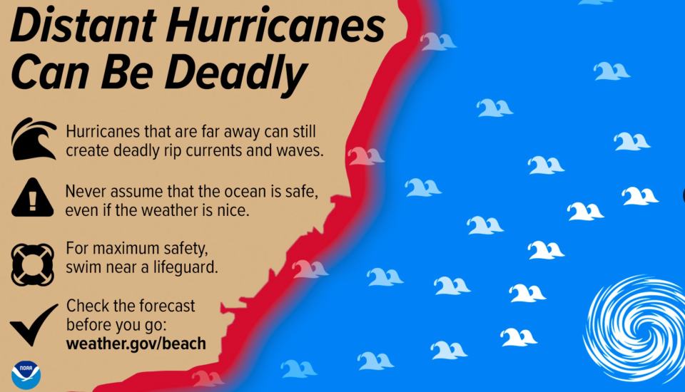
Forecasters have warned for days that Hurricane Lee could produce dangerous rip currents on the US east coast, and those predicitions have come to pass.
The National Hurricane Centre reported Monday morning that dangerous rip currents — which can drag swimmers out to sea — have begun in the southeastern US.
“Dangerous surf and rip currents have begun to affect portions of the southeastern U.S. coast, and these conditions are forecast to spread northward along much of the U.S. East Coast during the next couple of days,” the centre warned.
Swimmers in southeastern US states should consult their local weather information providers before heading out for a swim over the next few days.
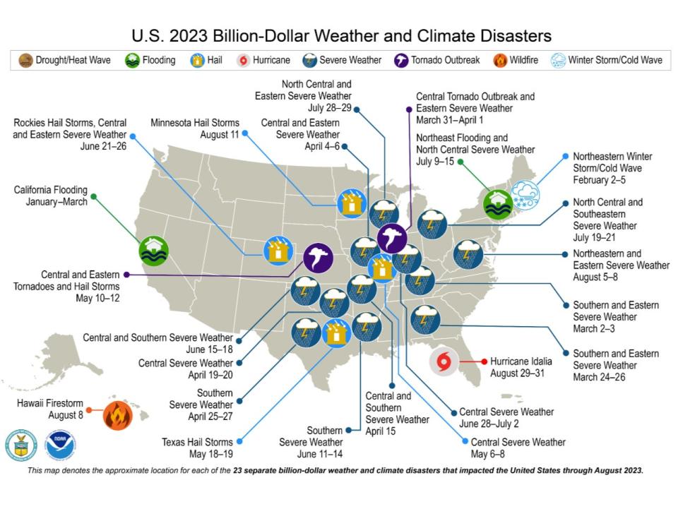
2023 sets the record for number of billion-dollar climate disasters
Monday 11 September 2023 18:00 , Graig Graziosi
The NOAA has identified 23 seperate climate and weather disasters in 2023 that caused at least a billion dollars in damages, according to the agency.
Those events include Hurricane Idalia, which struck Florida’s western shoreline near Big Bend in late August, the devastating wildfire on Maui that killed more than 100 people, and a number of lesser reported but still highly damaging weather and climate disasters.
Severe storms, tornadoes, and hail blasted the Plains states in the spring, while California saw record breaking floods between January and March.
“There have been 23 confirmed weather and climate disaster events this year, each with losses exceeding $1bn. These disasters consisted of 18 severe storm events, two flooding events, one tropical cyclone, one winter storm and one wildfire event,” the NOAA reports. “For this year-to-date period, the first eight months of 2023 rank highest for disaster count, ahead of 2020 with 16 disasters. The total cost of these events exceeds $57.6bn, and they have resulted in 253 direct and indirect fatalities.”
Monday 11 September 2023 17:34 , Graig Graziosi
Hurricane Lee is expected to gain strength for the next two days before gradually weakening as the the week wears on, according to the National Hurricane Centre.
The storm is expected to pass near Bermuda on its way north.
The centre said the hurricane’s impact on the US east coast and Atlantic Canada is still unknown. Some spaghetti models of show Hurricane Lee skirting close to the coast, others place it further out in the Atlantic.
“Some strengthening is forecast over the next day or so, followed by gradual weakening. Hurricane-force winds extend outward up to 75 miles (120 km) from the center and tropical-storm-force winds extend outward up to 185 miles (295 km),” the National Hurricane Centre said in an 11am EST update.
Tropical Storm Margot expected to become a hurricane tonight as path remains uncertain
Monday 11 September 2023 17:11 , Graig Graziosi
The National Hurricane Centre expects Tropical Storm Margot to strengthen into a hurricane sometime tonight, making it the second storm in as many weeks to spin up in the Atlantic basin.
“At 900 AM GMT (0900 UTC), the center of Tropical Storm Margot was located near latitude 25.3 North, longitude 40.0 West. Margot is moving toward the north near 8 mph (13 km/h), and this general motion is expected to continue during the next several days,” the National Hurricane Centre said in an advisory.
Forecasters are expecting it to gain strength over the next 48 hours. The storm’s winds are currently peaking around 65mph (104km/h).
READ MORE:
Tropical Storm Margot expected to become hurricane tonight as path remains uncertain
Hurricane Lee’s late-week impact on US east coast, Canada, still unknown
Monday 11 September 2023 16:27 , Graig Graziosi
Hurricane’s Lee’s potential late-week impact on the US east coast and Canada is still unknown, according to the National Hurricane Centre.
“It remains too soon to know what level of impacts, if any, Lee might have along the U.S. East Coast and Atlantic Canada late this week, especially since the hurricane is expected to slow down considerably over the southwestern Atlantic,” the centre said on Monday.
It did note, however, that high surf and rip currents were still likely along the coast.
Heavy rains and high surf possible risk for Bermuda this week
Monday 11 September 2023 15:27 , Graig Graziosi
Hurricane Lee may bring heavy rains, strong winds, and high surf to Bermuda later this week as it continues its journey through the Atlantic basin and along the US east coast.
“Lee could bring wind, rainfall, and high surf impacts to Bermuda later this week. Although it is too soon to determine the specific timing and level of those impacts, interests on Bermuda should monitor the latest forecasts for Lee,” the National Hurricane Centre said in a report.
Hurricane Lee is expected to gradually shift north by the middle of the week.
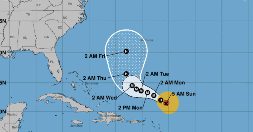
Hurricane Lee: Latest National Hurricane Centre report says storm should begin to swing north by midweek
Monday 11 September 2023 14:45 , Graig Graziosi
Hurricane Lee continued churning in the Atlantic on Monday after reaching its peak as a Category 5 storm on Thursday.
The National Hurricane Centre reports that Hurricane Lee is producing maximum sustained winds of 120mph (195km/h) — a Category 3 hurricane — and is on a northwesterly trajectory moving at 7mph (11km/h).
The centre believes Hurricane Lee will continue taking a "slow" path toward the west-northwest over the next few days before turning gradually north by the middle of the week.
The storm is expected to pass well north of the Virgin Islands and Puerto Rico. It is currently approximately 340 miles (545km) north of the Northern Leeward Islands and approximately 650 miles (1045km) south-southeast of Bermuda.
We’re in the ‘peak’ of Atlantic hurricane season
Monday 11 September 2023 14:00 , Alex Woodward
Sunday’s climatological peak of the Atlantic hurricane season – with conditions ripe for tropical storms and hurricanes – saw considerable action, with a strengthening Category 3 hurricane and soon-to-be hurricane tracking closely together, followed by two brewing systems to their west.
The “peak” date typically sees ocean waters at their highest temperatures, peak intensity in the atmosphere to generate thunderstorms, and shearing winds that can suffocate storms declining to a minimum, which tropical waves that fuel storms in the summer continue well into September.
What happens when hurricanes ‘collide’?
Monday 11 September 2023 13:00 , Stuti Mishra
Tropical Storm Margot is expected to reach hurricane status on Monday, raising the prospect of two potentially major hurricanes spinning in the Atlantic simultaneously and in similar paths.
That phenomenon, when two storms rotate around each other and spin in the same direction, is called the Fujiwhara effect. The National Weather Service describes it as “an intense dance around their common center” and potentially combine into one major storm.
The rare phenomenon occured with hurricanes Hilary and Irwin in the East Pacific in 2017.
If one hurricane is stronger than the other, the smaller one will orbit it and eventually come crashing into its vortex to be absorbed, according to the NHC.
“Two storms closer in strength can gravitate towards each other until they reach a common point and merge, or merely spin each other around for a while before shooting off on their own paths,” the center explains.
Hurricane season, by the numbers
Monday 11 September 2023 12:00 , Alex Woodward
NOAA forecasts 12 to 17 total named storms this year, with five to nine of those storms turning into hurricanes, including up to four major hurricanes with winds of 111 mph or higher.
The season, which officially began on 1 June and will end on 30 November, already has produced 14 storms, including four hurricanes – theree of which were Category 3 or higher.
Lee is the strongest yet among them.
Half of world’s population suffered under climate crisis-fuelled extreme heat this year, research says
Monday 11 September 2023 11:00 , Stuti Mishra
Nearly half of the world’s population was exposed to at least 30 days of extreme heat driven by the climate crisis between June and August, according to recently published research from Climate Central.
More than 3.8 billion people across the world suffered extreme temperatures for over a month, while “nearly every living human” – around 98 per cent of the world – was exposed to extreme heat at least once between June and August 2023, the report found.
The longest duration of extreme temperatures, approximately three months, was experienced by at least 1.5 billion people who were exposed to unusually high heat on each day over the period of June to August, the study says.
The Independent’s Stuti Mishra reports:
Half of world’s population suffered under extreme heat this summer, study says
Atlantic to see two simultaneous hurricanes as Margot strengthens
Monday 11 September 2023 10:00 , Stuti Mishra
Hurricane Lee is expected to continue to gain strength as it cruises across the Atlantic Ocean, and just behind it is Tropical Storm Margot, which forecasters predict will reach hurricane strength today.
Tropical Storm Margot became the 13th named storm after forming on Thursday evening, but it was far out in the Atlantic and posed no threat to land. It was last spotted about 1,185 miles (1,910 kilometres) west-northwest of the Cape Verde Islands late on Sunday night. Its winds stood at 65 mph (100 kph) and it was moving northward at 8 mph (13 kph).
It’s unclear what path they will take in the coming days, and whether they will pose a threat to the East Coast.
But they could get close enough for a phenomenon called the Fujiwhara effect, in which two storms rotate around each other and spin in the same direction. The National Weather Service describes it as “an intense dance around their common center.”
The phenomenon occured with hurricanes Hilary and Irwin in the East Pacific in 2017.
Can Hurricane Lee become Category 5 again?
Monday 11 September 2023 09:00 , Stuti Mishra
Lee is going through another phase of intensification over the warm Atlantic waters, nearing Category 4 strength now after it was downgraded to Category 2 on Saturday.
National Hurricane Center has said the storm could intensify further on Monday morning, which means it could once again become a Category 5 storm.Last week the storm went from Category 1 to Category 5 within 24 hours.
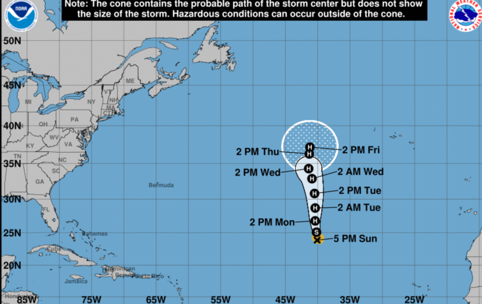
Path of Hurricane Lee: Will it make landfall?
Monday 11 September 2023 08:04 , Stuti Mishra
Hurricane Lee is projected to stay in open waters, according to the National Hurricane Center but its impact is being felt in the Caribbean with rainfall and large swells and the same could be experienced in the US East Coast.
Lee is expected to take a turn to the north by Wednesday. However, its path after that remained unclear.
Here is the projected path of the hurricane:
Hurricane Lee 'growing larger' as US east coast braces for large swells
Monday 11 September 2023 07:15 , Stuti Mishra
The centre of Hurricane Lee is growing in size, the National Hurricane Center has said in its latest advisory, after the storm once again intensified to Category 3 from Category 2 on Sunday night.
Lee has hurricane-force winds extending outward up to 75 miles (120 kilometres) from the centre and tropical storm-force winds extending outward up to 175 miles (280 kilometres).
The NHC also said that dangerous surf and rip currents were expected to hit most of the US East Coast starting on Sunday night and Monday morning, but that the hurricane's impact beyond that was still unclear.
"It is way too soon to know what level of impacts, if any, Lee might have along the US East Coast, Atlantic Canada, or Bermuda, especially since the hurricane is expected to slow down considerably over the southwestern Atlantic." the centre said.
Hurricane #Lee Advisory 23: Lee Growing Larger But Maximum Sustained Winds Have Not Yet Increased. Hazardous Beach Conditions Expected to Spread Through the Western Atlantic During the Week. https://t.co/tW4KeGe9uJ
— National Hurricane Center (@NHC_Atlantic) September 11, 2023
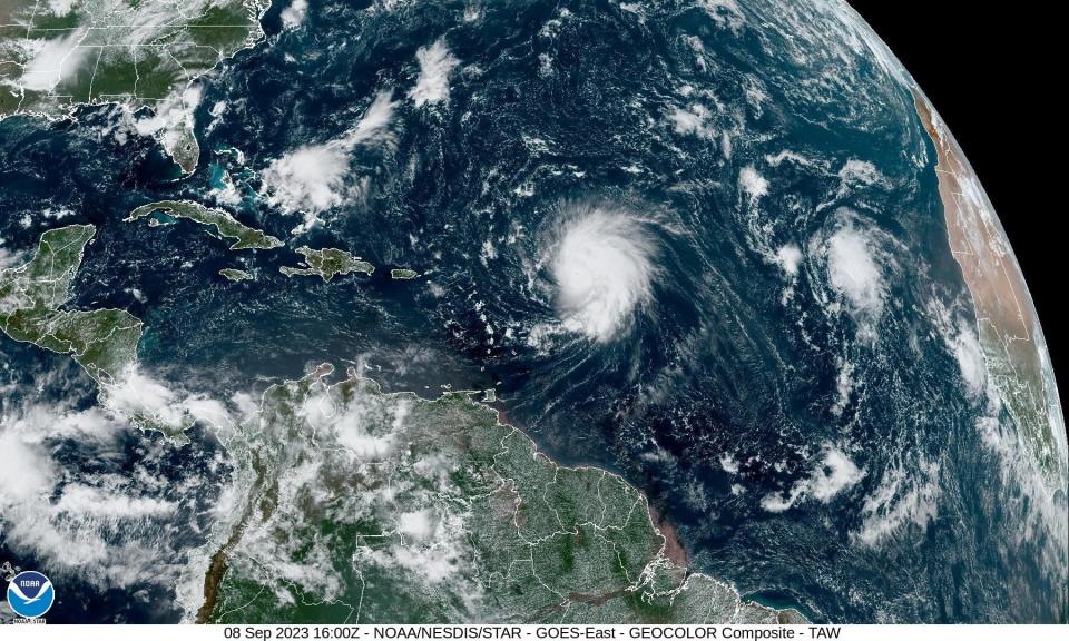
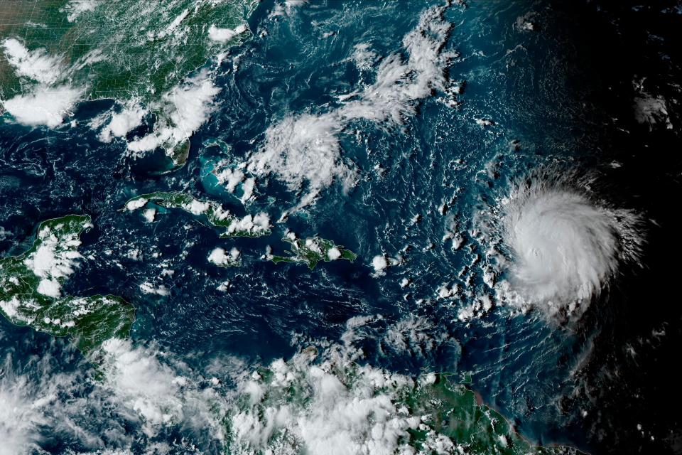
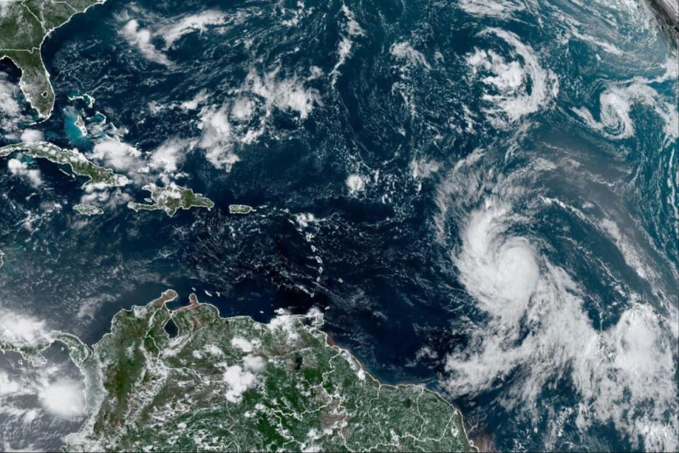
Hurricane Lee unleashes heavy swell on northern Caribbean as it restrengthens over open waters
Monday 11 September 2023 06:32 , Stuti Mishra
Hurricane Lee barrelled over open waters late night just northeast of the Caribbean, unleashing heavy swell on several islands as it regained some strength and expanded in size.
Lee has again intensified to a Category 3 storm after reducing to Category 2 earlier on Saturday, but it is not forecast to make landfall and it is staying over open waters. However, its bands brought heavy rains and hazardous beach conditions.
The impacted regions include the Lesser Antilles, the British and US Virgin Islands, Puerto Rico, Hispaniola, the Turks and Caicos Islands, the Bahamas and Bermuda.
Late Sunday, it was centred about 310miles (500kilometres) north of the northern Leeward Islands. Its maximum sustained winds were clocked at 120mph (195kph) and it was moving northwest at 8mph (13kph).
“We had the perfection conditions for a hurricane: warm waters and hardly any wind shear,” said Lee Ingles, a forecaster with the National Weather Service in San Juan.
‘Rapid intensification’ of storms likely to accelerate with warming waters
Monday 11 September 2023 06:00 , Alex Woodward
Hurricane Lee is in rare company. Only two recorded storms – Hurricane Wilma in 2005 and Hurricane Felix in 2007 – strengthened faster than Lee over a 24-hour period, as Lee developed from a Cat 1 to a Cat 5 last week before degrading into its current Cat 3 status.
The storm is predicted to continue to regain strength after slowing down over the weekend.
Brian McNoldy with the University of Miami told NBC News that the warm conditions in the Atlantic were ripe for the storm’s rapid intensification last week.
The “vertical wind shear was very low and the water temperature under it was very warm,” he said, adding that Lee “took full advantage of both.”
Last year, Hurricane Ian rapidly intensified over two separate periods before striking Florida. Hurricane Idalia recently strengthened from a Cat 1 to a Cat 4 within 24 hours.
“It’s a huge problem, and the past is not a good guide to what we should expect going forward,” Jeff Masters, a former hurricane scientist with the National Oceanic and Atmospheric Administration, told NBC.
Forecasters predoct another rapid intensification cycle for Lee
Monday 11 September 2023 04:00 , Alex Woodward
Lee made history last week after it rapidly intensified from a Category 1 to a Category 5 within 24 hours.
The hurricane could enter another period of rapid intensification this week after slowing down over the weekend.
In the last 12 hours, NHC has recorded a 15 knot increase for #HurricaneLee, confirming that #Lee is steadily re-intensifying. The next 36 hours are looking like medium-low shear so I wouldn’t be surprised if we get near a rapid intensification cycle between today and tomorrow. pic.twitter.com/OYPoaxFCux
— Kieran Bhatia (@BhatiaKieran) September 10, 2023
East Coast likely to avoid Lee landfall, but hazardous beach conditions are incoming
Monday 11 September 2023 02:00 , Alex Woodward
It appears that Hurricane Lee will likely avoid making any landfall in the US, but life-threatening rip currents and dangerous beaches conditions along the East Coast are expected over the next couple of days.
“Dangerous surf and rip currents are expected to begin along much of the US East Coast later today and worsen through this week,” according to the National Hurricane Center.
Beach erosion and some coastal flooding is also possible, the center reported.
The Category 3 storm is predicted to continue gaining strength as it moves north this week.
5pm AST Sun Sep 10th Key Messages for #Hurricane #Lee.
Hazardous beach conditions to spread across the western Atlantic this week. Too soon to know level of impacts for US East coast or Atlantic Canada late this week, so stay tuned for updates. https://t.co/w5INoaj9KX pic.twitter.com/NaXXHp21Mz— National Hurricane Center (@NHC_Atlantic) September 10, 2023
Atlantic will see two simultaneous hurricanes this week, forecasters predict
Monday 11 September 2023 00:00 , Alex Woodward
Hurricane Lee is expected to continue to gain strength as it cruises across the Atlantic Ocean, and just behind it is Tropical Storm Margot, which forecasters predict will reach hurricane strength on 11 September.
It’s unclear what path they will take in the coming days, and whether they will pose a threat to the East Coast.
But they could get close enough for a phenomenon called the Fujiwhara effect, in which two storms rotate around each other and spin in the same direction. The National Weather Service describes it as “an intense dance around their common center.”
The phenomenon occured with hurricanes Hilary and Irwin in the East Pacific in 2017.
Tropical Storm Margot is growing ‘stronger’ and ‘better organized’ and predicted to turn into a hurricane on Monday
Sunday 10 September 2023 22:30 , Alex Woodward
Just behind Hurricane Lee is Tropical Storm Margot, which has grown “stronger” and “better organized” over the weekend, according to the National Hurricane Center.
Margot is expected to continue moving north in the next few days and potentially intensify into a hurricane on Monday.
Maximum sustained winds have increased to near 65 mph with higher gusts. Tropical storm-force winds extend outward up to 80 miles from the storm’s center, according to the advisory.
Latest Lee update: Hurricane ‘restrengthening’ as Category 3 storm
Sunday 10 September 2023 21:50 , Alex Woodward
As predicted, Hurricane Lee has intensified into a Category 3 storm after slowing down overnight and into Sunday.
Lee is expected to take a slow west-northwestward track in the coming days, passing well north of the northern Leeward Islands, the Virgin Islands and Puerto Rico during the next day or two, according to a Sunday afternoon advisory from the National Hurricane Center.
The storm has returned to Category 3 strength and “additional strengthening” is forcast within the next day or so, the NHC is reporting.
There are no coastal watches or warnings in effect, and it remains unclear whether the storm will reach the northeastern US coast and Canada or continue spinning into the Atlantic on that western track. It still remains too early to tell, according to forecasters.
5pm AST Sun Sep 10th Key Messages for #Hurricane #Lee.
Hazardous beach conditions to spread across the western Atlantic this week. Too soon to know level of impacts for US East coast or Atlantic Canada late this week, so stay tuned for updates. https://t.co/w5INoaj9KX pic.twitter.com/NaXXHp21Mz— National Hurricane Center (@NHC_Atlantic) September 10, 2023
Watch: Atlantic storm activity at the ‘peak’ of hurricane season
Sunday 10 September 2023 20:30 , Alex Woodward
Take a look at the Atlantic activity with Hurricane Lee, Tropical Storm Margot and two disturbances behind them with a chance of developing into storms in the coming days
The storms and storms-to-be are taking shape during the “peak” of the Atlantic hurricane season.
NOAA forecasts 12 to 17 total named storms this year, with five to nine of those storms turning into hurricanes, including up to four major hurricanes with winds of 111 mph or higher.
There's no shortage of activity in the Atlantic Basin! Along with named storms Hurricane #Lee and Tropical Storm #Margot, the #NHC is monitoring a pair of disturbances in the Main Development Region that each have a 30% chance of development over the next 7 days. pic.twitter.com/rZpRxTeOmW
— RadarOmega (@RadarOmega) September 10, 2023
Hurricane Lee is a Category 2 storm, but it’s still unclear where it’s headed
Sunday 10 September 2023 19:55 , Alex Woodward
Hurricane Lee was downgraded to a Category 2 on Sunday, slowing down as it rears northwest along the eastern seaboard.
It’s expected to strengthen in the coming days, but Lee is not projected to strike land, and there are no coastal watches or warnings in effect, for now.
“It remains too soon to know what level of impacts, if any, Lee might have along the US East Coast, Atlantic Canada or Bermuda late next week, especially since the hurricane is expected to slow down considerably over the southwestern Atlantic,” according to the National Hurricane Center.
Dangerous surf conditions are expected along parts of the East Coast and around the northern Leeward Islands, Virgin Islands and Puerto Rico as well as Hispaniola, the Turks and Caicos Islands, the Bahamas, and Bermuda.
But the storm, roughly 270 miles northeast of the northern Leeward Islands, is expected to steer away from Caribbean islands as it makes its northern turn.
Why Hurricane Lee has shattered ‘rapid intensification’ standards
Sunday 10 September 2023 18:00 , Alex Woodward
Hurricane Lee’s acceleration from an 80 mph Cat 1 to a Cat 5 with 160 mph winds within 24 hours has surpassed the standards meteorologists typically associate with “rapid intensification,” or when winds increase by 35 mph within that same time period.
It not only makes Lee the one of the fastest-intensifying Atlantic storms on record, it has set a new threshold that scientists see as a potential harbinger for what’s to come as the climate crisis accelerates.
“This one increased by 80 mph,” Marshall Shepherd, director of the University of Georgia’s Atmospheric Sciences Program and a past president of the American Meteorological Society told the Associated Press. “I can’t emphasize this enough – we used to have this metric of 35 mph, and here’s a storm that did twice that amount and we’re seeing that happen more frequently.”
September 10 is ‘peak’ hurricane season, as more Atlantic storms are brewing
Sunday 10 September 2023 17:00 , Alex Woodward
Today is the “peak” date for the Atlantic hurricane season, and it couldn’t come at a more-active time, with Hurricane Lee likely gaining strength as Tropical Storm Margot and two brewing storms pop up behind it.
“September 10 is basically when you still have low vertical wind shear, plenty of moisture and increasing sea surface temperatures,” Colorado State meteorologist Philip Klotzbach told AccuWeather. “The increasing vertical wind shear tends to dominate over the continued warming sea surface temperatures as you move later in September.”
On the heels of #Lee and Margot is #invest97L and it’s larger relative near Africa. These two should blend in time. Given it’s the heart of the hurricane season and the entire basin is ripe, this new system may follow a similar path that Lee has traveled thus far. By NEXT… pic.twitter.com/O4SitQiZ5x
— Jim Cantore (@JimCantore) September 10, 2023
While the climate crisis and warming waters have indicated that hurricane seasons are trending longer than the official six-month window typically observed, that “peak” date is likely to remain.
“While Atlantic sea surface temperatures typically continue to warm until late September/early October, vertical wind shear starts to increase relatively quickly in late September, knocking down storm activity,” Mr Klotzbach added.
Latest Lee update: Storm to pass ‘well north’ of Leeward Islands, Virgin Island and Puerto Rico
Sunday 10 September 2023 16:32 , Alex Woodward
Hurricane Lee, now a Category 2 storm, is expected to spin outwards as it approaches the eastern seaboard, and the storm is moving “well north” of the northern Leeward Island, Virgin Islands and Puerto Rico in the coming days, according to an 11am ET update from the National Hurricane Center.
Still, it remains too early to tell what impacts, if any, will be felt along the US East Coast and Canada, “especially as the hurricane is expected to slow down considerably” as it moves over the southwestern Atlantic, according to the advisory.
Data from a NOAA Hurricane Hunter aircraft indicate that maximum sustained winds have increased to nearly 110 mph with higher gusts, and “some strengthening is forecast during the next couple of days.”
Dangerous waves are expected along the East Coast throughout the weekend, with potentially life-threatening rip currents and dangerous surf hitting northern Leeward Island, Virgin Islands and Puerto Rico as well as Hispaniola, the Turks and Caicos Islands, the Bahamas, and Bermuda.
11AM AST Sep 10: #Lee is passing well north of the northern Leeward Islands. Hazardous beach conditions are forecast to spread across the western Atlantic this week. Stay up to date with the latest at https://t.co/tW4KeGe9uJ pic.twitter.com/FSB4BYvbIQ
— National Hurricane Center (@NHC_Atlantic) September 10, 2023
Latest Lee update: Storm is ‘slowing down’ and likely regaining strength as it steers north
Sunday 10 September 2023 14:30 , Alex Woodward
After it was downgraded from a Category 3 storm, Hurricane Lee is predicted to regain strength as it travels along warm Atlantic waters in the coming days.
Lee is “slowing down” as it moves well north of Puerto Rico, the Virgin Islands and the northern Leeward Islands, though it still remains too early to determine its course and whether the northeastern US coast and Canada could see any impacts, according to an advisory from the National Hurricane Center on 10 September.
But life-threatening surf and rip conditions are expected along the East Coast, while dangerous swells generated by the storm are spreading to the Virgin Islands, Puerto Rico, Hispaniola, the Turks and Caicos Islands, the Bahamas, and Bermuda.
5 AM AST - Sept 10: #Lee slowing down...Deteriorating seas and beach conditions expected this week for PR/USVI.
|#Lee está desacelerando...Se esperan condiciones marítimas y costeras deterioradas esta semana para PR/USVI.#PRwx #USVIwx pic.twitter.com/WFwxiTULEG— NWS San Juan (@NWSSanJuan) September 10, 2023
Will Lee and Margot collide in the Atlantic?
Sunday 10 September 2023 11:00 , Alex Woodward
Newly formed Tropical Storm Margot is expected to grow into a hurricane next week, raising the possibility that it could mingle or alter Hurricane Lee’s path, though it is still far too soon to project whether the two major storms could get close to one another any time soon in the Atlantic Ocean.
Such a phenomenon, when two storms rotate around each other and spin in the same direction, is called the Fujiwhara effect. The National Weather Service describes it as “an intense dance around their common center.”
That could then push them both around the Atlantic and alter their paths.
The phenomenon occured with hurricanes Hilary and Irwin in the East Pacific in 2017.
‘Rapid intensification’ of storms likely to accelerate with warming waters
Sunday 10 September 2023 09:00 , Alex Woodward
Hurricane Lee is in rare company. Only two recorded storms – Hurricane Wilma in 2005 and Hurricane Felix in 2007 – strengthened faster than Lee over a 24-hour period, as Lee developed from a Cat 1 to a Cat 5 last week before degrading into its current Cat 3 status.
Brian McNoldy with the University of Miami told NBC News that the warm conditions in the Atlantic were ripe for the storm’s rapid intensification.
The “vertical wind shear was very low and the water temperature under it was very warm,” he said, adding that Lee “took full advantage of both.”
Warm waters are a potent fuel for hurricanes to gain strength, a phenomenon likely to accelerate amid a growing climate crisis and warming waters.
Last year, Hurricane Ian rapidly intensified over two separate periods before striking Florida. Hurricane Idalia recently strengthened from a Cat 1 to a Cat 4 within 24 hours.
“It’s a huge problem, and the past is not a good guide to what we should expect going forward,” Jeff Masters, a former hurricane scientist with the National Oceanic and Atmospheric Administration, told NBC.
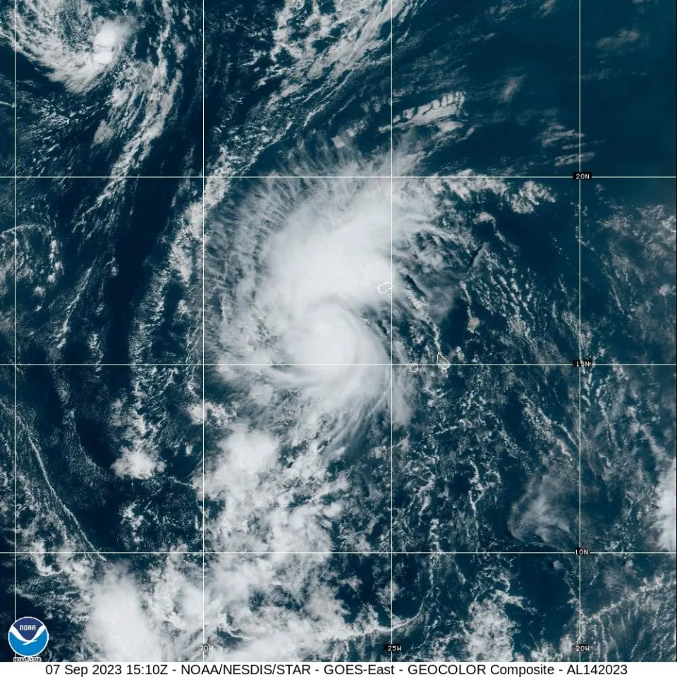
Why Lee is blowing meteorologists’ minds before it even makes landfall
Sunday 10 September 2023 07:00 , Alex Woodward
The first Category 5 storm of the Atlantic hurricane season didn’t stay that way very long, but Hurricane Lee’s rapid intensification from a Category 1 into a Category 5 within 24 hours from Thursday into Friday is likely a record-breaking event in modern meteorological history.
The storm then degraded into a Cat 4 then a Cat 3, though it is likely to gather strength as it moves northeast.
Cat 5 storms already are rare, but inreasingly more common, relative to the history books. According to University of Miami hurricane expert Brian McNoldy, roughly 4 per cent of named storms in the Atlantic basin have reached that threshold since the early 1920s.
Category 5 hurricanes are rare... these are tropical cyclones with 157mph+ sustained winds in the eyewall. Meteorological perfection. What percentage of Atlantic named storms is known to have reached Cat 5 intensity?
1923-2023: 3.8%
1973-2023: 3.5%
1993-2023: 3.6%
2013-2023: 4.5%— Brian McNoldy (@BMcNoldy) September 8, 2023
Lee’s intensification from an 80 mph Cat 1 to a Cat 5 with 160 mph winds has likely made it the fastest-intensifying Atlantic storm on record.
Not only that, for the first time on record, Cat 5 storms have formed in every tropical ocean basin within one year.
This is one of the most impressive rapid intensification episodes I've ever seen in the Atlantic. Hurricane #Lee went from having no eye this morning to possibly Cat 5 intensity this evening. Absolutely incredible. pic.twitter.com/49NmtkIJO2
— Dr. Levi Cowan (@TropicalTidbits) September 8, 2023
FEMA stocks up food and water for potential Puerto Rico and US Virgin Islands response
Sunday 10 September 2023 03:00 , Alex Woodward
The USS Federal Emergency Management Agency has roughly 4.5 million meals and nearly 8.9 million liters of water in Puerto Rico as Hurricane Lee rears eastward as a powerful Category 3 storm that could gain strength over the weekend.
The storm is not yet predicted to make landfall, if it does at all, but emergency responders and national weather agencies are keeping a close watch.
Roughly 250,000 meals and more than 600,000 liters of water are prepared to support the US Virgin Islands, FEMA also announced on Friday.
‘A major wave producer'
Sunday 10 September 2023 01:00 , Alex Woodward
It still remains far too early to tell what Lee will look like for the East Coast as it creeps along a northeastern track, but forecasters predict high seas and rip currents up and down the Eastern Seaboard.
“What we are going to see from Lee – and we’re very confident – is it’s going to be a major wave producer,” National Hurricane Center director Mike Brennan said in a Friday briefing.
On Saturday, large swells battered the northeast Caribbean as Lee churned through open waters hundreds of miles off the northern Leeward Islands, the Associated Press reported.
The highest waves recorded by the center were at about 45 and 50 feet, and the “highest waves could even be double that,” Mr Brennan said.
“So we could be looking at 80-, 90-foot waves associated with Lee,” he added.
How close will Lee get to the US?
Saturday 9 September 2023 23:00 , Alex Woodward
Exactly when or how Lee will travel northeast is still too early to tell. What happens next is up to a combination of atmospheric factors, including an area of high pressure in the Atlantic Ocean and a jet stream to its west.
That area of high pressure is likely to play a major role in Lee’s track, and is expected to keep Lee on its current west-northwestward path over the weekend. That scenario would keep the storm rotating out to sea, or send it closer to Bermuda.
The storm is still roughly one week from posing a potential threat to the East Coast of the US, if it poses any at all.
Latest Lee advisory: Hurricane expected to pass north of Leeward Islands while generating dangerous waves over weekend
Saturday 9 September 2023 22:10 , Alex Woodward
Hurricane Lee, still a Category 3 storm, is expected to pass “pass well to the north of the northern Leeward Islands, the Virgin Islands, and Puerto Rico into early next week,” according to an afternoon advisory from the National Hurricane Center.
Maximum sustained winds are near 115 mph with higher gusts, and gradual “restrengthening” is possible during the next couple of days, the center predicts.
Swells generated by Lee are affecting portions of the Lesser Antilles and will spread westward to the British and US Virgin Islands, Puerto Rico, Hispaniola, the Turks and Caicos Islands, the Bahamas, and Bermuda through the weekend. Those swells are “likely to cause life-threatening surf and rip current conditions,” according to the report.
“Dangerous surf and rip currents” are also expected along the US East Coast on Sunday and Monday and then worsen through the week.
Hurricane #Lee Advisory 18: Lee to Pass Well North of the Leeward Islands During the Next Day Or So. Hazardous Beach Conditions Expected to Develop Around the Western Atlantic Through Next Week. https://t.co/tW4KeGe9uJ
— National Hurricane Center (@NHC_Atlantic) September 9, 2023
Too soon to tell but too soon to rule out significant impacts, forecasters say
Saturday 9 September 2023 22:00 , Alex Woodward
Hurricane Lee was significantly disrupted by wind shear within the 24 hours after it accelerated into a Category 5 hurricane, as it then degraded into a Category 4 then Category 3 into Saturday morning.
Models are suggesting that the shear will subside by Sunday morning, which could allow Lee to gain more strength as it continues to track east, according to Levi Cowan with Joint Typhoon Warning Center.
“Regardless of Lee’s exact intensity, it will be a major hurricane tracking north of the Caribbean and then turning northward over the western Atlantic over the next week,” he said.
“It remains too soon to rule out impacts from Lee” as models predict it could track forwards Bermuda, Canada and the northeastern US, he added.
Hurricane #Lee has been disrupted significantly by some mid-level wind shear in the past 24 hours, with max winds down to 115 mph after being as high as 160 mph at one point. Models suggest that the shear will subside by Sunday morning, probably allowing Lee to regain strength.… pic.twitter.com/vOikNUrYQs
— Dr. Levi Cowan (@TropicalTidbits) September 9, 2023
Lee shattered ‘rapid intensification’ standards, a warning of future storms amid growing climate crisis
Saturday 9 September 2023 21:02 , Alex Woodward
Hurricane Lee’s acceleration from an 80 mph Cat 1 to a Cat 5 with 160 mph winds within 24 hours has surpassed the standards meteorologists typically associate with “rapid intensification,” or when winds increase by 35 mph within that same time period.
It not only makes Lee the fastest-intensifying Atlantic storm on record, it has set a new threshold that scientists see as a potential harbinger for what’s to come as the climate crisis accelerates.
“This one increased by 80 mph,” Marshall Shepherd, director of the University of Georgia’s Atmospheric Sciences Program and a past president of the American Meteorological Society told the Associated Press. “I can’t emphasize this enough – we used to have this metric of 35 mph, and here’s a storm that did twice that amount and we’re seeing that happen more frequently.”
Lee and Margot could mingle in the Atlantic
Saturday 9 September 2023 18:57 , Alex Woodward
Newly formed Tropical Storm Margot is expected to grow into a hurricane next week, raising the possibility that Hurricane Lee’s path could be changed, though it is still far too soon to project whether the two major storms could get close to one another in the Atlantic.
Such a phenomenon, when two storms rotate around each other and spin in the same direction, is called the Fujiwhara effect. The National Weather Service describes it as “an intense dance around their common center.”
That could then push them both around the Atlantic and alter their paths.
The phenomenon occured with hurricanes Hilary and Irwin in the East Pacific in 2017.
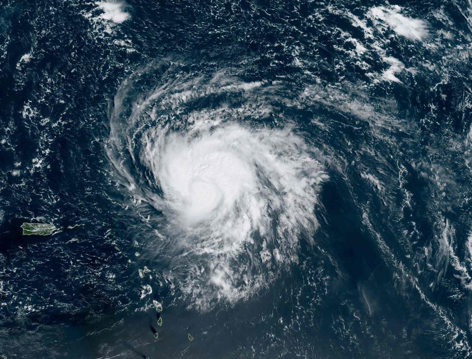
Watch Lee intensify from Category 1 to Category 5 storm
Saturday 9 September 2023 18:04 , Alex Woodward
Lee marked the first Category 5 hurricane of this year’s Atlantic season when it rapidly grew from a Category 1 within 24 hours this week. There have been seven other Cat 5 storms from the Atlantic since 2016, with one – Michael – making landfall in the US in 2018.
Within thouse 24 hours, Hurricane Lee intensified from an 80 mph Cat 1 to a Cat 5 with 160 mph winds, likely making it the fastest-intensifying Atlantic storm on record.
Lee has since diminished to a Cat 3 storm and is expected to maintain its strength over the weekend.
#Lee's life story, Chapter 1: From African easterly wave to sudden extreme intensification into a Category 5 #hurricane (wait for it) pic.twitter.com/1EWakTRkBe
— Stu Ostro (@StuOstro) September 8, 2023
Lee ‘maintaining strength’ but ‘little change expected’ on Saturday
Saturday 9 September 2023 16:25 , Alex Woodward
Hurricane Lee is “maintaing strength” as a recently downgraded Category 3 storm as it moves across the Atlanta Ocean with maximum sustained winds of 115 mph with higher gusts, according to the latest advisory from the National Hurricane Center.
“Little change in strength is expected today, but gradual restrengthening is forecast to occur on Sunday and Monday,” according to the advisory.
11AM AST Sep 9: @NOAA_HurrHunter & @53rdWRS find #Lee maintaining strength this morning. Hazardous beach conditions are expected around the western Atlantic through next week. Visit https://t.co/tW4KeGe9uJ for the latest information pic.twitter.com/xXiy8NY8Ux
— National Hurricane Center (@NHC_Atlantic) September 9, 2023
Lee is in rare company during an already-historic storm year
Saturday 9 September 2023 15:35 , Alex Woodward
For the first time on record, Category 5 storms have formed in every tropical ocean basin within one year.
Lee, which has since downgraded to a Category 3 as it tracks along open Atlantic Ocean, accelerated from Category 1 strength into a Category 5 this week.
“I think it’s reasonable to hypothesize that the abnormally warm ocean temperatures around the world made this more likely to happen,” University of Miami, hurricane expert Brian McNoldy told The Washington Post. “Gives everything a boost.”
Saturday, Sept 9th 5 AM AST Key Messages for Hurricane #Lee: It is too soon to know what level of impacts, if any, Lee might have along the U.S. East Coast, Atlantic Canada, or Bermuda late next week. Continue to monitor forecasts at https://t.co/tW4KeGe9uJ for the latest. pic.twitter.com/2106DvFQFh
— National Hurricane Center (@NHC_Atlantic) September 9, 2023
‘Way too soon’ to chart US impacts, if any, but Lee could strengthen as it moves across open ocean
Saturday 9 September 2023 14:30 , Alex Woodward
Hurricane Lee ramped up to a Category 5 storm within 24 hours this week, but it has been downgraded to a Category 3 and will likely lose strength over the course of the day as it struggles with wind shear.
The National Hurricane Center continues to stress it is still “way too soon” to know what impacts, if any, the storm could have along the East Coast of the US, and the storm could gain strength as it continues to move with sustained winds at 115 mph as of Saturday morning.
Dangerous and life-threatening rip currents are affecting parts of the Leeward Islands, according to NHC. Those conditions are expected to impact parts of Puerto Rico, Hispaniola, the Turks and Caicos Islands, the Bahamas and Bermuda over the weekend.
Saturday, Sept 9th 5 AM AST Key Messages for Hurricane #Lee: It is too soon to know what level of impacts, if any, Lee might have along the U.S. East Coast, Atlantic Canada, or Bermuda late next week. Continue to monitor forecasts at https://t.co/tW4KeGe9uJ for the latest. pic.twitter.com/2106DvFQFh
— National Hurricane Center (@NHC_Atlantic) September 9, 2023
Will Hurricane Lee reach New York?
Saturday 9 September 2023 11:06 , Louise Boyle
Some forecast models suggest that Hurricane Lee could graze the US East Coast - but the jury is still out.
“Regardless, dangerous surf and rip currents are expected along most of the US East Coast beginning Sunday,” the National Hurricane Center warned.
Joe Sommerlad reports
Will Hurricane Lee reach New York?
Watch: Inside the eye of Hurricane Lee
Saturday 9 September 2023 10:07 , Louise Boyle
Lee gains elite status
Saturday 9 September 2023 09:03 , Louise Boyle
Lee is expected to keep strengthening and reach winds of up to 180mph (290kph).
Only seven Atlantic hurricanes have had winds of that magnitude since 1966, according to Colorado State University hurricane researcher Phil Klotzbach.
Among those was Hurricane Dorian, which pummeled the northern Bahamas in 2019 as a Category 5 storm, hovering over small islands for some two days.
The Associated Press
Lee gains elite status
Saturday 9 September 2023 05:05 , Louise Boyle
Lee is expected to keep strengthening and reach winds of up to 180mph (290kph).
Only seven Atlantic hurricanes have had winds of that magnitude since 1966, according to Colorado State University hurricane researcher Phil Klotzbach.
Among those was Hurricane Dorian, which pummeled the northern Bahamas in 2019 as a Category 5 storm, hovering over small islands for some two days.
The Associated Press
Watch: Inside the eye of Hurricane Lee
Saturday 9 September 2023 04:04 , Louise Boyle
Hurricane Lee powers through Caribbean as forecasters warn ‘too soon to know’ of US impact next week
Saturday 9 September 2023 01:01 , Graeme Massie
‘We will see waves between 10 and 15 feet, so we don’t want anyone on the beaches’.
Hurricane Lee powers through Caribbean as ‘too soon to know’ on US impacts next week
Ocean warnings
Saturday 9 September 2023 00:03 , Louise Boyle
The National Hurricane Center said that dangerous surf and deadly rip currents will likely hit the northern Leeward Islands later Friday from Hurricane Lee.
They would spread to Puerto Rico, Hispaniola, the Turks and Caicos, the Bahamas and Bermuda over the weekend.
“We will see waves between 10 and 15 feet (3 and 5 meters), so we don’t want anyone on the beaches,” said Ernesto Morales with the National Weather Service in San Juan, Puerto Rico.
The National Hurricane Center said dangerous surf and rip currents were forecast for most of the US East Coast starting Sunday. (AP)
Will Hurricane Lee reach New York?
Friday 8 September 2023 23:02 , Louise Boyle
Some forecast models suggest that Hurricane Lee could graze the US East Coast - but the jury is still out.
“Regardless, dangerous surf and rip currents are expected along most of the US East Coast beginning Sunday,” the National Hurricane Center warned.
Joe Sommerlad reports
Will Hurricane Lee reach New York?
FEMA prepared for worst-case scenario in Puerto Rico in response to Hurricane Lee
Friday 8 September 2023 22:00 , Graig Graziosi
Hurricane Lee strengthened to a Category 5 storm on Thursday evening. The same day, Joe Biden was briefed by the Federal Emergecy Management Agency about its preparations in the event the storm’s force caused disruptions in Puerto Rico and the US Virgin Islands.
FEMA said it had prepared approximately 4.5 million meals and nearly 8.9 million liters of water for Puerto Rico. Another 250,000 meals and more than 600,000 liters of water were made available for the US Virgin Islands.
The agency also deployed rapid response teams to both of the US territories in the event the storm turned and threatened the islands.
Thankfully, Hurricane Lee did not make landfall on any of the islands and is continuing north along the US east coast.
‘No reason’ for east coast US residents to be fearful of Hurricane Lee
Friday 8 September 2023 21:40 , Graig Graziosi
Jamie Rhome, the director of the National Hurricane Centre, said that right now there is “no reason” for east coast US residents to fear Hurricane Lee’s trajectory outside of rip current risks.
“There’s absolutely no indication in front of us that this is going to be a huge threat to Florida, other than it’s going to be a huge rip current risk,” Mr Rhome told USA Today. “Right now, save the rip current risk, which is extreme, there’s no reason for people on the East Coast to be fearful. We need them to be informed and aware and check back for details but right now there’s no reason other than rip currents for people to be fearful.”
Hurricane Lee underwent rapid intensification, strengthening from a Category 2 to Category 4 storm in just six hours, according to the National Hurricane Centre.
The storm became a Category 5 hurricane on Thursday night, but has since weakened to a Category 4.
Tracking Hurricane Lee’s evolution
Friday 8 September 2023 21:10 , Graig Graziosi
Tropical Storm Lee formed in the Atlantic Ocean and under went rapid intensification into an “extremely dangerous” hurricane, eventually reaching Category 5 before it slowed to Category 4 on Friday morning.
Tropical Storm Lee was announced by the National Hurricane Center (NHC) at 5pm (eastern time) on Tuesday.
Its wind speeds picked up on Tuesday afternoon and was forecast to become a major hurricane.
“The depression is forecast to become a major hurricane by this weekend and could bring impacts to the Leeward Islands by that time,” NHC reported at the time.
READ MORE:

Tropical Storm Lee expected to become ‘extremely dangerous’ hurricane by weekend
Hurricane Lee: What is the path of the monster storm?
Friday 8 September 2023 20:50 , Graig Graziosi
Hurricane Lee reached Category 5 on Friday, after “rapidly strengthening” as it stirred through the Caribbean, the US National Hurricane Center reported on Thursday.
Hurricane Lee began to strengthen over the very warm waters of the Atlantic, growing from a tropical storm into a Category 1 hurricane on Wednesday and by late Thursday night, it had grown to Category 5, with maximum sustained winds of 160mph.
By Friday morning, forecasters said Lee could become a “monster 180mph” storm.
The storm reached its peak Thursday night and became to be a vicious hurricane over the southwestern Atlantic before weakening to a Category 4 on Friday morning.
READ MORE:
Tracking Hurricane Lee: What is the path of the monster storm?
Will Hurricane Lee reach New York?
Friday 8 September 2023 20:30 , Graig Graziosi
Hurricane Lee, currently barreling westwards through the Atlantic towards the Caribbean islands, rapidly intensified into a Category 5 storm on Thursday night and it is feared the storm could soon work up to wind speeds of 180mph.
It is expected to pass well to the north of the northern Leeward Islands, the Virgin Islands and Puerto Rico over the weekend and into early next week, according to forecasters.
After that, however, its path is less clear cut, with different models reaching different verdicts as to precisely how close it could pass along the US East Coast as it steers northwards, already inspiring some premature and slightly hysterical tabloid headlines.
More credibly, CBS has warned that Hurricane Lee’s path “might” bring it to New York City and the Tri-State Area, reporting that initial forecasts suggested “a landfall in the Mid-Atlantic region, and then riding up the coastline towards New York” before drifting out to sea.
READ MORE:
Will Hurricane Lee reach New York?
National Hurricane Centre warns of surf, rip currents in the Caribbean, US east coast
Friday 8 September 2023 20:07 , Graig Graziosi
The National Hurricane Centre has warned that Hurricane Lee — now a Category 4 storm after it strengthened into a Category 5 storm on Thursday — could produce high surf and life-threatening rip currents in the northeastern Caribbean on Friday and throughout the weekend.
The centre also said that rough surf and hazardous ocean conditions were likely along much of the US east coast by Sunday evening.
Hurricane Lee is continuing to churn in the Atlantic basin, with spaghetti models predicting a northern track, with a possible threat to New England and Canada’s east coast.
Hurricane Lee still ‘very powerful’ despite weakening
Friday 8 September 2023 19:30 , Graig Graziosi
The National Hurricane Centre said that Hurricane Lee is still a “very powerful” storm despite weakening from a Category 5 to a Category 4 storm between Thursday night and Friday morning.
“Although Lee’s current intensity is lower than the overnight peak, the hurricane remains very powerful,” the centre said.
Hurricane Lee is expected to remain a strong storm into early next week as it continues north through the Atlantic. It is still unclear what impact it might have on the US, but some spaghetti models show the storm on a course for New England and Canada’s east coast.
Half of world’s population suffered under climate crisis-fuelled extreme heat this year
Friday 8 September 2023 19:10 , Louise Boyle
Half the world was exposed to at least 30 days of extreme heat driven by the climate crisis between June and August, a new study has found.
Over 3.8 billion people suffered extreme temperatures for more than a month, while “nearly every living human” – around 98 per cent of the world – was exposed to extreme heat at least once between June and August 2023, an analysis released on Thursday by the nonprofit Climate Central showed.
The longest duration of extreme temperatures, approximately three months, was experienced by at least 1.5 billion people, the study says.
“Virtually no one on Earth escaped the influence of global warming during the past three months,” Dr Andrew Pershing, vice president for science at Climate Central, said.
Stuti Mishra reports
Half of world’s population suffered under extreme heat this summer, study says
‘Hurricane hunter' pilot captures lightning show inside Hurricane Lee
Friday 8 September 2023 19:00 , Graig Graziosi
A user on X/Twitter recorded video from the inside of Hurricane Lee, capturing a stunning lightning storm inside the churning storm.
Hurricane Lee underwent rapid intensification yesterday, strengthening from a Category 2 to a Category 4 storm in just six hours.
The storm reached Category 5 on Thursday night before weakening back to a Category 4 on Friday.
Nice lighting show in the eye of #HurricaneLee this morning pic.twitter.com/F3Spj54syS
— FlyAnon (@FlynonymousWX) September 8, 2023
Ocean warnings
Friday 8 September 2023 18:38 , Louise Boyle
The National Hurricane Center said that dangerous surf and deadly rip currents will likely hit the northern Leeward Islands later Friday from Hurricane Lee.
They would spread to Puerto Rico, Hispaniola, the Turks and Caicos, the Bahamas and Bermuda over the weekend.
“We will see waves between 10 and 15 feet (3 and 5 meters), so we don’t want anyone on the beaches,” said Ernesto Morales with the National Weather Service in San Juan, Puerto Rico.
The National Hurricane Center said dangerous surf and rip currents were forecast for most of the US East Coast starting Sunday. (AP)
Will Hurricane Lee reach New York?
Friday 8 September 2023 18:05 , Louise Boyle
Some forecast models suggest that Hurricane Lee could graze the US East Coast - but the jury is still out.
“Regardless, dangerous surf and rip currents are expected along most of the US East Coast beginning Sunday,” the National Hurricane Center warned.
Joe Sommerlad reports
Will Hurricane Lee reach New York?
Watch: Inside the eye of Hurricane Lee
Friday 8 September 2023 17:33 , Louise Boyle
Lee gains elite status
Friday 8 September 2023 17:10 , Louise Boyle
Lee is expected to keep strengthening and reach winds of up to 180mph (290kph).
Only seven Atlantic hurricanes have had winds of that magnitude since 1966, according to Colorado State University hurricane researcher Phil Klotzbach.
Among those was Hurricane Dorian, which pummeled the northern Bahamas in 2019 as a Category 5 storm, hovering over small islands for some two days.
The Associated Press
‘Distant but deadly'
Friday 8 September 2023 16:40 , Louise Boyle
US forecasters had this warning for Americans on Friday as Category 5 Hurricane Lee roars through the Caribbean.
“Distant hurricanes can be deadly,” NOAA warned and said that beach-goers should be aware of rip currents and powerful waves.
Inside the eye of Hurricane Lee
Friday 8 September 2023 16:15 , Louise Boyle
The US Air Force Reserve’s “Hurricane Hunters” shared dramatic footage from inside Hurricane Lee on Thursday night.
The 403rd Wing Reserves posted on X, formerly Twitter, footage of the rotating thick clouds with lightning bursts.
“Here’s last night’s flight inside the eye of Cat 5 Hurricane Lee,” they wrote.
Here’s last night’s flight inside the eye of Cat 5 #hurricaneLee pic.twitter.com/I9Gmy4sHut
— Hurricane Hunters (@53rdWRS) September 8, 2023
Will Hurricane Lee make landfall?
Friday 8 September 2023 15:43 , Louise Boyle
The current forecasts show that Hurricane Lee is not expected to make landfall in the coming days - but that doesn’t rule out “life-threatening” impacts.
The storm is forecast to pass well to the north of the northern Leeward Islands, the Virgin Islands, and Puerto Rico over the weekend and into early next week.
However, “it is way too soon” to know what level of impacts, if any, Lee might have along the US East Coast, Atlantic Canada or Bermuda, late next week, according to the National Weather Service.
Watch: Hurricane Lee gathering strength in Caribbean waters
Friday 8 September 2023 15:27 , Louise Boyle

