Hurricane Lee is ‘growing in size’ with flood threat for New England: Live forecast
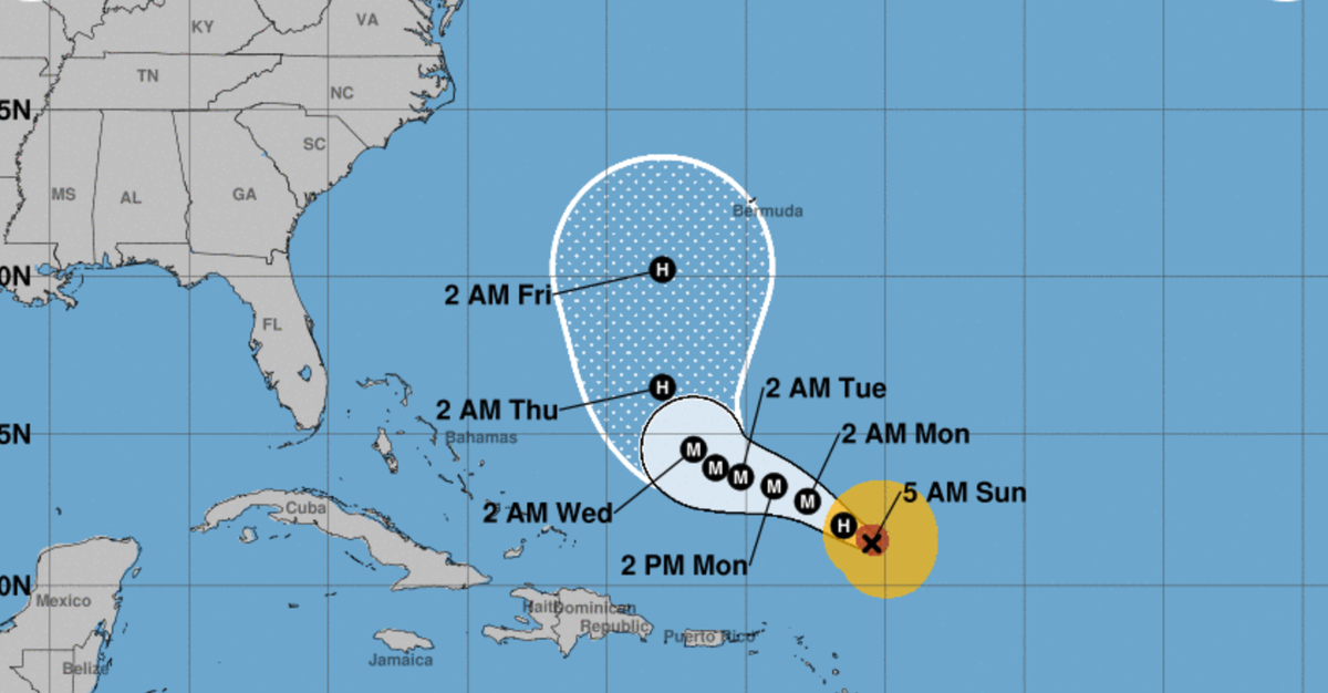
Hurricane Lee is “growing in size” and forecast to turn north on Thursday, increasing in forward speed, according to the National Weather Service (NWS).
Forecasters believe that Lee will make landfall in Nova Scotia, Canada as a tropical storm on Sunday, bringing winds and widespread flooding to large parts of New England - Rhode Island, eastern Massachusetts, southeastern New Hampshire and central and coastal Maine.
The slow-moving storm is currently 535 miles (860km) south of Bermuda, where a tropical storm watch was issued on Tuesday.
“Lee is very large hurricane. Hurricane-force winds extend outward up to 125miles (205km) from the center and tropical-storm-force winds extend outward up to 240miles (390 km),” NWS reported today.
Hazardous surf and rip current conditions are expected at beaches up and down the US East Coast and Atlantic Canada this week.
“Life-threatening” coastal conditions are also being experienced in parts of the Lesser Antilles, the British and US Virgin Islands, Puerto Rico, Hispaniola, the Turks and Caicos Islands, the Bahamas, and Bermuda.
Behind Lee is Hurricane Margot, the fifth hurricane of the 2023 season. Margot is tracking north for now, the NWS reported, but that the forecast beyond Friday was “highly uncertain”.
Key Points
Latest update: Hurricane Lee could see storm-force winds extend 300 miles from its core
Map of Hurricane Lee as storm expected to make northward turn
The models forecasting Lee’s likely progress
The hurricane’s projected path
Storm Margot strengthens into hurricane
Hurricane Lee swirls through open waters on a path to Atlantic Canada
13:00 , Martha Mchardy
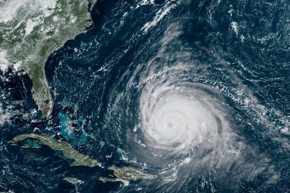
Hurricane Lee whirled north of Puerto Rico on Tuesday as a Category 3 storm, with forecasters noting it would remain in open waters through this week while on a path to Atlantic Canada.
The storm was located 575 miles (925 kilometers) south of Bermuda. It had winds of up to 115 mph (185 kph) and was moving west-northwest at 7 mph (11 kph).
By Sunday, Lee was forecast to weaken into a tropical storm and likely make landfall in Nova Scotia, Canada, according to AccuWeather.
Read more:

Hurricane Lee swirls through open waters on a path to Atlantic Canada
Latest satellite image of Hurricane Lee
12:30 , Martha Mchardy
In this satellite image provided by the National Oceanographic and Atmospheric Administration via NASA, Hurricane Lee continues its slow west-northwest trajectory across the Atlantic Ocean.
Watch: Inside the eye of Hurricane Lee
12:00 , Martha Mchardy
Lee expected to make landfall in Canada
11:30 , Martha Mchardy
Hurricane Lee is expected to make landfall in Canada as a tropical storm, forecasters have said.
Lee is set to hit Nova Scotia, Canada on Sunday, bringing winds and widespread flooding.
On the forecast track, the center of Lee will pass west of Bermuda on Thursday before approaching the coast of New England or Atlantic Canada late this week.
Dangerous surf and rip currents to continue affecting western Atlantic into the weekend
10:49 , Martha Mchardy
Dangerous surf and rip currents are expected to continue affecting areas around the western Atlantic into the weekend, the National Hurricane Center has said.
Portions of the northern Leeward Islands, the Virgin Islands, Puerto Rico, Hispaniola, the Turks and Caicos Islands, the Bahamas, Bermuda, and most of the East Coast will be affected throughout much of the week.
It comes as a tropical storm warning has been issued for Bermuda and the US East Coast, with heavy rainfall expected throughout Thursday.
The National Hurricane Center said early Wednesday morning that Lee is now a “very large hurricane” and is producing large swells which will impact parts of the western Atlantic all week.
5 am AST Wednesday, Sep. 13 Key Messages for Hurricane #Lee. Dangerous surf and rip currents will continue to affect areas around the western Atlantic into the weekend.https://t.co/8sILm5tGbP pic.twitter.com/VmxDDxDC6g
— National Hurricane Center (@NHC_Atlantic) September 13, 2023
Hurricane Lee expected to weaken in upcoming days
10:30 , Martha Mchardy
Hurricane Lee is expected to weaken in upcoming days as it enters cooler waters, the National Hurricane Center has said.
“Despite the weakening that is forecast, keep in mind that the expanding wind field of Lee will produce impacts well away from the storm center,” the center said.
Lee was generating dangerous surf and rip currents for the Lesser Antilles, the British and U.S. Virgin Islands, Puerto Rico, Hispaniola, the Turks and Caicos Islands, the Bahamas, Bermuda and parts of the southeast U.S. coast. Those conditions were expected to soon spread to the U.S. East Coast.
“It remains too soon to know what level of additional impacts Lee might have along the northeastern U.S. coast and Atlantic Canada late this week and this weekend,” the National Hurricane Center said.
Latest pictures from Massachusetts after hit by 10 inches of rain
10:00 , Martha Mchardy


Latest update on Lee: Bermuda under tropical storm warning
09:30 , Rachel Sharp
A tropical storm warning has been issued for Bermuda and the US East Coast is bracing for “life-threatening” rip currents and dangerous surf as Hurricane Lee continues to chart its path across the Atlantic.
The National Hurricane Center said early Wednesday morning that Lee is now a “very large hurricane” and is producing large swells which will impact parts of the western Atlantic all week.
Swells are affecting parts of the Lesser Antilles, the British and US Virgin Islands, Puerto Rico, Hispaniola, the Turks and Caicos Islands, the Bahamas, and Bermuda, the agency said.
Meanwhile, dangerous surf and rip currents are affecting parts of the southeastern US coast, with conditions forecast to spread north along much of the East Coast and Atlantic Canada over the coming days.
11PM AST Sep 12: A tropical storm warning has been issued for Bermuda. #Lee is a very large hurricane producing large swells with dangerous surf and life-threatening rip currents expected at beaches across the western Atlantic all week. Stay up to date at https://t.co/tW4KeGe9uJ pic.twitter.com/EYKUM8yW5c
— National Hurricane Center (@NHC_Atlantic) September 13, 2023
Watch: Inside the eye of Hurricane Lee
04:51 , Louise Boyle
Hurricane Lee’s path
03:52 , Louise Boyle
Hurricane Lee is expected to turn north later this week and forecasters suggested that it would make landfall in Nova Scotia, Canada as a tropical storm on Sunday.
Winds and flooding also are expected to affect Rhode Island, eastern Massachusetts, southeastern New Hampshire and central and coastal Maine this weekend, forecasters said.
‘Not heading for NYC'
02:50 , Louise Boyle
The New York Metro Weather account on X, formerly Twitter, had a warning for New Yorkers on Tuesday.
“Hurricane Lee is still not heading for NYC, despite what the clickbait articles and social media videos might be trying to tell you,” a post read.
“Here’s what we can expect as the storm passes by.”
Hurricane Lee is still not heading for NYC, despite what the clickbait articles and social media videos might be trying to tell you. Here’s what we can expect as the storm passes by: https://t.co/iCfS5WZVK6
— New York Metro Weather (@nymetrowx) September 12, 2023
One bumpy ride
01:50 , Louise Boyle
The 403rd Wing of the US Air Force Reserve Command, otherwise known as the “Hurricane Hunters”, shared this video of their aerial weather reconnaissance of Hurricane Lee at the weekend.
Sometimes #Hurricane flights can get a little bumpy.
Video by Tech. Sgt Nate Calloway, Sept. 8, into hurricane #Lee pic.twitter.com/PFSWrJvyEi— Hurricane Hunters (@53rdWRS) September 12, 2023
Libya flood: 10,000 missing, 1,500 bodies recovered after Storm Daniel sends wall of water through city of Derna
Wednesday 13 September 2023 00:50 , Louise Boyle
Emergency workers uncovered more than 1,500 bodies in the wreckage of Libya’s eastern city of Derna on Tuesday, and it was feared the toll could spiral with 10,000 people reported still missing after floodwaters smashed through dams and washed away entire neighborhoods of the city.
The startling death and devastation wreaked by Mediterranean storm Daniel pointed to the storm’s intensity, but also the vulnerability of a nation torn apart by chaos for more than a decade.
The country is divided by rival governments, one in the east, the other in the west, and the result has been neglect of infrastructure in many areas.
Outside help was only just starting to reach Derna on Tuesday, more than 36 hours after the disaster struck. The floods damaged or destroyed many access roads to the coastal city of some 89,000. (Associated Press)

10,000 missing as deadly flood from Storm Daniel sweeps through Libyan city of Dernia
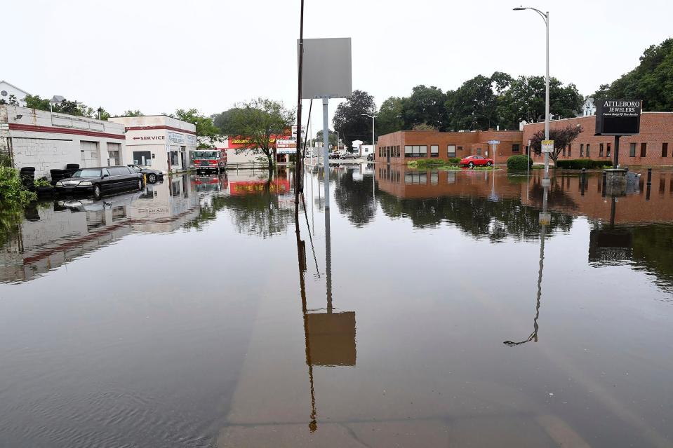
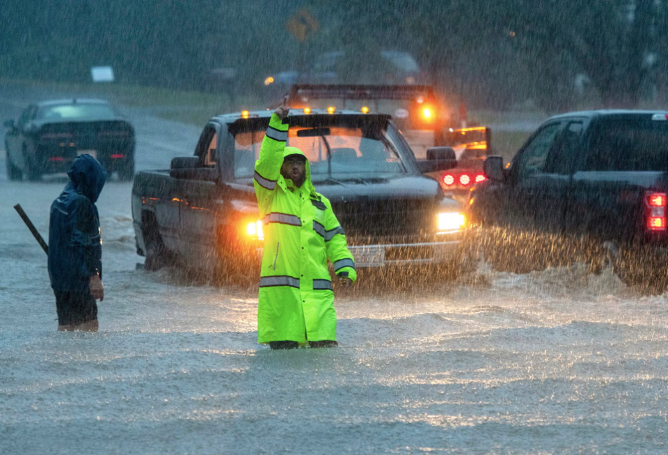
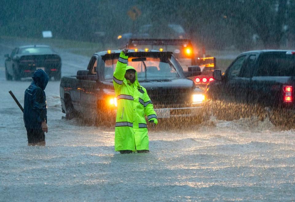
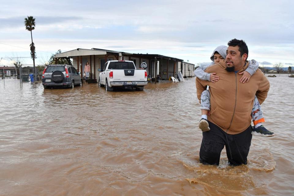
Massachusetts city gets 11 inches of rain, flooding homes, jeopardizing dam
Tuesday 12 September 2023 23:50 , Louise Boyle
Heavy rainfall has flooded parts of Massachusetts and Rhode Island, with one city declaring a state of emergency as water poured into homes, creating moats around their foundations and leading to boat rescues of residents. Concern about a dam listed in poor condition led to more evacuations.
More storms were in the forecast for Wednesday, and although it was still early, winds and flooding from Hurricane Lee were expected to affect Rhode Island, eastern Massachusetts, southeastern New Hampshire and central and coastal Maine during the weekend, forecasters said.
Up to 300 people were evacuated by Tuesday morning in Leominster, about 40 miles northwest of Boston, Mayor Dean Mazzarella said. That included residents of a high-rise apartment building and a nursing home. All schools were closed and two shelters were opened.
Read more
Heavy rain brings flash flooding in parts of Massachusetts and Rhode Island
Flood watch for large parts of Massachusetts
Tuesday 12 September 2023 22:50 , Louise Boyle
A flood watch was issued from 11am on Wednesday into Thursday morning by the Boston office of the National Weather Service.
One to two inches of rain is expected across the area, although localized amounts up to 4 inches are possible. Flooding is likely and forecasters warned people not to drive through submerged streets or underpasses.
The warning came after central Massachusetts was pounded by several inches of rainfall on Monday leading states of emergency to be declared in the cities of Leominster and North Attleborough.
📆 Flood Watch - 11 AM Wednesday - 7 AM Thursday
🌧️ 1-2 inches of rain, although localized amounts up to 4 inches are possible.
⚠️ Excessive runoff may result in flooding of streets, urban areas, as well as low-lying, poor drainage and flood-prone locations.#MAwx #RIwx #CTwx pic.twitter.com/ZgS3No9QBH— NWS Boston (@NWSBoston) September 12, 2023
Margot makes five
Tuesday 12 September 2023 21:50 , Louise Boyle
Hurricane Margot became the fifth named hurricane of the Atlantic season on Monday.
On Tuesday, it was located some 890 miles (1,430 kilometers) southwest of the Azores with maximum sustained winds of 85mph (140 kph) and was moving north at 12mph (19 kph).
The hurricane is forecast to remain over open waters. Regardless, Swells generated by Margot will begin to affect the Azores on Wednesday. These swells are likely to cause life-threatening surf and rip current conditions.
Lee impacts coastal areas hundreds of miles from storm
Tuesday 12 September 2023 20:48 , Louise Boyle
Forecasters warned of dangerous surf and rip currents affecting the southeastern US coast from Tuesday due to Hurricane Lee and local emergency departments backed up those alerts.
“Pay attention to beach warning flags and do not enter the water in unsafe conditions,” warned the Florida Division of Emergency Management.
Offshore impacts from distant Hurricane Lee may cause increasingly dangerous beach conditions along the E coast, including a high risk of rip currents & elevated wave heights throughout the week.
Pay attention to beach warning flags & do not enter the water in unsafe conditions. pic.twitter.com/5q2xAlDCbq— FL Division of Emergency Management (@FLSERT) September 12, 2023
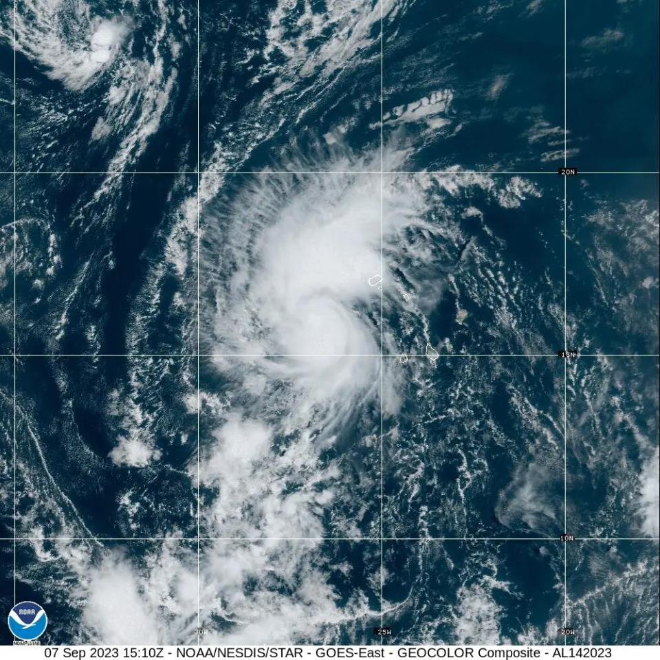
Satellites capture the twin hurricanes
Tuesday 12 September 2023 19:50 , Louise Boyle
The US National Oceanic and Atmospheric Administration’s satellites captured the twin storms of Lee and Margot swirling in the Atlantic today.
Hurricane Lee was seen just north of Puerto Rico, and Hurricane Margot was strengthening farther east. Lee is a powerful Category 3 storm and is expected to cause hazardous surf and rip conditions at beaches across the western Atlantic this week.
This morning, @NOAA's #GOESEast 🛰️ is watching two hurricanes swirl over the Atlantic—#Lee, north of Puerto Rico, and #Margot, strengthening farther east.
Lee is a powerful Category 3 storm and is expected to cause hazardous surf and rip conditions at beaches across the western… pic.twitter.com/4Hq9n5lX6n— NOAA Satellites (@NOAASatellites) September 12, 2023
Watch: Hurricane Lee takes aim at Canada
Tuesday 12 September 2023 19:31 , Louise Boyle
Watch: Here’s where Hurricane Lee and Hurricane Margot are tracking
Tuesday 12 September 2023 17:47 , Louise Boyle
Hurricane Lee’s path
Tuesday 12 September 2023 17:37 , Louise Boyle
Hurricane Lee is expected turn north later this week and forecasters suggested that it would make landfall in Nova Scotia, Canada as a tropical storm on Sunday.
Winds and flooding also are expected to affect Rhode Island, eastern Massachusetts, southeastern New Hampshire and central and coastal Maine this weekend, forecasters said.
AP
Tropical Storm watch issued for Bermuda
Tuesday 12 September 2023 17:10 , Louise Boyle
A tropical storm watch has been issued for Bermuda, the US National Hurricane Center reported in its late morning update.
Hazardous surf and rip current conditions are expected at beaches across the western Atlantic all week, the report added.
Major Hurricane Lee churns in the western Atlantic.
The storm is offshore, but dangerous surf and rip currents are affecting the southeastern US coast are are expected to move northward over the next few days. pic.twitter.com/3JTw0oXf4k— CIRA (@CIRA_CSU) September 12, 2023
Satellites capture Lee... with Margot not far behind
Tuesday 12 September 2023 17:43 , Louise Boyle
This morning, @NOAA's #GOESEast 🛰️ is watching two hurricanes swirl over the Atlantic—#Lee, north of Puerto Rico, and #Margot, strengthening farther east.
Lee is a powerful Category 3 storm and is expected to cause hazardous surf and rip conditions at beaches across the western… pic.twitter.com/4Hq9n5lX6n— NOAA Satellites (@NOAASatellites) September 12, 2023
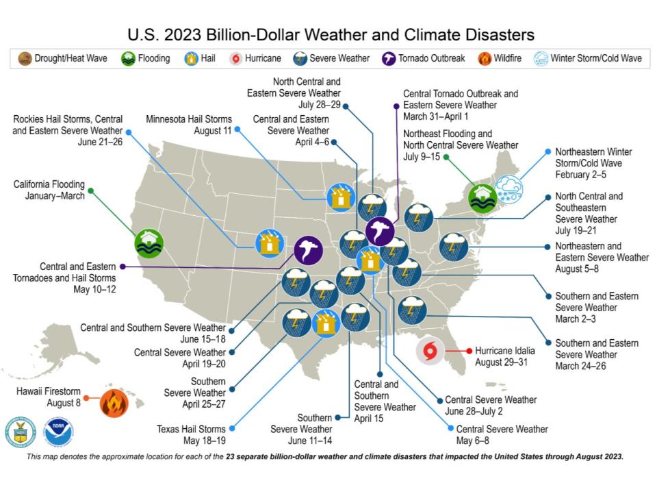
US sets record for billion-dollar weather disasters in a year — and there’s still 4 months to go
Tuesday 12 September 2023 16:38 , Louise Boyle
The deadly firestorm in Hawaii and Hurricane Idalia’s watery storm surge helped push the United States to a record for the number of weather disasters that cost $1 billion or more. And there’s still four months to go on what’s looking more like a calendar of calamities.
The National Oceanic and Atmospheric Administration announced Monday that there have been 23 weather extreme events in America that cost at least $1 billion this year through August, eclipsing the year-long record total of 22 set in 2020. So far this year’s disasters have cost more than $57.6 billion and claimed at least 253 lives.
And NOAA’s count doesn’t yet include Tropical Storm Hilary’s damages in hitting California and a deep drought that has struck the South and Midwest because those costs are still to be totaled, said Adam Smith, the NOAA applied climatologist and economist who tracks the billion-dollar disasters.
Read more
US sets record for billion-dollar weather disasters in a year -- and there's still 4 months to go
Watch: Inside the eye of Hurricane Lee
Tuesday 12 September 2023 16:03 , Louise Boyle
Hurricane Lee: The latest update
Tuesday 12 September 2023 15:23 , Louise Boyle
The Category 3 system remains a slow-moving, major storm and is forecast to go through “additional strengthening” in the coming days in the warm Atlantic waters.
The hurricane is currently moving west-northwest near 7mph (11kph) before it turns north mid-week, passing west of Bermuda, according to the 5am (eastern time) update from the US National Hurricane Center (NHC).
Swells generated by Lee are causing life-threatening surf and rip currents in parts of the Lesser Antilles, the British and US Virgin Islands, Puerto Rico, Hispaniola, the Turks and Caicos Islands, the Bahamas, and Bermuda, according to NHC.
The southeastern US coast is also facing these hazardous conditions which are expected to spread north along much of the US East Coast in the next couple of days.
Atlantic sees two simultaneous hurricanes as Margot strengthens
Tuesday 12 September 2023 15:00 , Joe Sommerlad
Hurricane Lee is expected to continue to gain strength as it cruises across the Atlantic Ocean, and just behind it is Hurricane Margot, which reached hurricane status on Monday night. Margot is forecast to go through further strengthening during the next 48 hours, the US National Hurricane Center said in its latest advisory.
The hurricane was located about 1,265 miles (2,035km) northwest of the Cape Verde Islands, packing maximum sustained winds of 75mph (120kph), the Miami-based forecaster said.
Margot became a Category 1 storm Monday afternoon and was expected to continue to intensify to become the fifth hurricane of the season. It was forecast to remain over open waters.
It’s unclear what path they will take in the coming days, and whether they will pose a threat to the East Coast.
But they could get close enough for a phenomenon called the Fujiwhara effect, in which two storms rotate around each other and spin in the same direction. The National Weather Service describes it as “an intense dance around their common center.”
The phenomenon occured with hurricanes Hilary and Irwin in the East Pacific in 2017.
New Englanders “need to be careful” as Hurricane Lee heads for the US east coast
Tuesday 12 September 2023 14:00 , Graig Graziosi
John Cangialosi, senior hurricane specialist at the National Hurricane Center, said that New Englanders “need to be careful” if they have any seafaring adventures planned in the coming days.
Hurricane Lee may move close to the US northeast coast, bringing with it high waves, dangerous rip currents, and strong winds.
Mr Cangialosi told Boston.com that mariners should keep up-to-date with their local weather services before setting out to sea, especially later in the week as the hurricane moves further north.
“If you’re going to go offshore, you need to be careful,” Mr Cangialosi said. “You need to go now or wait for this to go by.”
Despite the warnings, researchers have noted that its unclear exactly what effect Hurricane Lee will have on northeastern states by the time it reaches the area.
The storm is still gaining strength, but will likely weaken as it hits colder northern waters. Despite its weakening, the storm may still produce high winds within hundreds of miles of its centre.
Hurricane Lee could see storm-force winds extend 300 miles from its core
Tuesday 12 September 2023 13:00 , Joe Sommerlad
Hurricane Lee is expected to continue to grow in size after its spins northward this week, the precise extent of which will determine severity of its impact on the northeastern United States, New England, Bermuda and Canada.
On Monday evening, Lee was categorised as a Category 3 hurricane and was situated north of the Leeward Islands and Puerto Rico in the Atlantic, hitting maximum wind speeds of 115 mph, according to the US National Hurricane Center (NHC).
The NHC says it will then likely weaken, expand in size and speed up in the wake of its anticipated northward turn along the East Coast.
A bigger storm, even if weaker, has the potential to impact a much larger area, possibly including the Eastern Seaboard, even without actually making landfall in North America.
“Even as the peak winds come down, the wind field of Lee is going to continue to grow in size,” NHC director Michael Brennan said in a Monday storm briefing, according to CNN.
“We could see the tropical storm-force winds expand by 50 to 60 to 70 per cent.”
Hurricane #Lee Advisory 28: Lee Remains a Large and Powerful Hurricane. Hazardous Surf and Rip Current Conditions Expected At Beaches Across the Western Atlantic All Week. https://t.co/tW4KeGe9uJ
— National Hurricane Center (@NHC_Atlantic) September 12, 2023
As of yesterday, hurricane-force winds extended 75 miles from Lee’s centre, up from 45 miles a day earlier. Tropical storm-force winds extended 185 miles from its core.
Those same winds could extend over 300 miles from Lee’s centre later this week, Mr Brennan said.
“There’s still a lot of uncertainty as to the exact track of how close it will get to the coast of New England and Atlantic Canada over the next several days,” he added.
“But certainly the chance for significant impacts with a growing storm.”
‘Rapid intensification’ of storms likely to accelerate with warming waters
Tuesday 12 September 2023 12:00 , Alex Woodward
Hurricane Lee is in rare company. Only two recorded storms – Hurricane Wilma in 2005 and Hurricane Felix in 2007 – strengthened faster than Lee over a 24-hour period, as Lee developed from a Cat 1 to a Cat 5 last week before degrading into its current Cat 3 status.
The storm is predicted to continue to regain strength after slowing down over the weekend.
Brian McNoldy with the University of Miami told NBC News that the warm conditions in the Atlantic were ripe for the storm’s rapid intensification last week.
The “vertical wind shear was very low and the water temperature under it was very warm,” he said, adding that Lee “took full advantage of both.”
Last year, Hurricane Ian rapidly intensified over two separate periods before striking Florida. Hurricane Idalia recently strengthened from a Cat 1 to a Cat 4 within 24 hours.
“It’s a huge problem, and the past is not a good guide to what we should expect going forward,” Jeff Masters, a former hurricane scientist with the National Oceanic and Atmospheric Administration, told NBC.
Watch: Footage from inside the NOAA’s flight into Hurricane Lee
Tuesday 12 September 2023 11:00 , Joe Sommerlad
The NOAA sent a “hurricane hunter” aircraft into Hurricane Lee on Sunday night to gather data on the now Category 3 storm churning in the Atlantic.
The agency filmed a portion of the flight, which shows the researchers being jostled back and forth by the storm’s sustained 120mph winds.
Hurricane Lee is expected to remain a powerful hurricane until midweek, when forecasters believe it will begin to weaken.
Watch the flight below:
#HurricaneLee will produce some monster waves (50ft+ near the core). Swells start to arrive Tues-Wed along the SE Coast and work north. Surfers will prob love it, but careful folks. Big time rip current risk! New moon means slightly elevated tides/ coastal flooding/ erosion too. pic.twitter.com/NrPCOLsysT
— Jeff Berardelli (@WeatherProf) September 8, 2023
Hurricane Lee generates 15 foot waves
Tuesday 12 September 2023 10:00 , Graig Graziosi
Hurricane Lee reportedly has generated 15 foot waves as it moves north of the Caribbean and into the waters off the US east coast, according to the Associated Press.
High surf and dangerous rip currents have already begun for some southeastern US states as the Category 3 hurricane continues on its trajectory further north.
Dangerous rip currents caused by Hurricane Lee begin to affect southeast US
Tuesday 12 September 2023 09:00 , Graig Graziosi
Forecasters have warned for days that Hurricane Lee could produce dangerous rip currents on the US east coast, and those predicitions have come to pass.
The National Hurricane Centre reported Monday morning that dangerous rip currents — which can drag swimmers out to sea — have begun in the southeastern US.
“Dangerous surf and rip currents have begun to affect portions of the southeastern U.S. coast, and these conditions are forecast to spread northward along much of the U.S. East Coast during the next couple of days,” the centre warned.
Swimmers in southeastern US states should consult their local weather information providers before heading out for a swim over the next few days.
2023 sets the record for number of billion-dollar climate disasters
Tuesday 12 September 2023 08:00 , Graig Graziosi
The NOAA has identified 23 seperate climate and weather disasters in 2023 that caused at least a billion dollars in damages, according to the agency.
Those events include Hurricane Idalia, which struck Florida’s western shoreline near Big Bend in late August, the devastating wildfire on Maui that killed more than 100 people, and a number of lesser reported but still highly damaging weather and climate disasters.
Severe storms, tornadoes, and hail blasted the Plains states in the spring, while California saw record breaking floods between January and March.
“There have been 23 confirmed weather and climate disaster events this year, each with losses exceeding $1bn. These disasters consisted of 18 severe storm events, two flooding events, one tropical cyclone, one winter storm and one wildfire event,” the NOAA reports. “For this year-to-date period, the first eight months of 2023 rank highest for disaster count, ahead of 2020 with 16 disasters. The total cost of these events exceeds $57.6bn, and they have resulted in 253 direct and indirect fatalities.”
Path of Hurricane Margot
Tuesday 12 September 2023 07:00 , Stuti Mishra
Margot which has strengthened into a hurricane now, is expected to continue to remain in open waters.
Here’s the path the storm is following:

Margot strengthens into a hurricane
Tuesday 12 September 2023 06:24 , Stuti Mishra
Tropical Storm Margot intensified into a hurricane on Monday night with further strengthening forecast during the next 48 hours, the US National Hurricane Center said in its latest advisory.
The hurricane was located about 1,265 miles (2,035km) northwest of the Cape Verde Islands, packing maximum sustained winds of 75mph (120kph), the Miami-based forecaster said.Margot became a Category 1 storm Monday afternoon and was expected to continue to intensify to become the fifth hurricane of the season. It was forecast to remain over open waters.
Hurricane Lee’s late-week impact on US east coast, Canada, still unknown
Tuesday 12 September 2023 04:59 , Graig Graziosi
Hurricane’s Lee’s potential late-week impact on the US east coast and Canada is still unknown, according to the National Hurricane Centre.
“It remains too soon to know what level of impacts, if any, Lee might have along the U.S. East Coast and Atlantic Canada late this week, especially since the hurricane is expected to slow down considerably over the southwestern Atlantic,” the centre said on Monday.
It did note, however, that high surf and rip currents were still likely along the coast.
Heavy rains and high surf possible risk for Bermuda this week
Tuesday 12 September 2023 04:00 , Graig Graziosi
Hurricane Lee may bring heavy rains, strong winds, and high surf to Bermuda later this week as it continues its journey through the Atlantic basin and along the US east coast.
“Lee could bring wind, rainfall, and high surf impacts to Bermuda later this week. Although it is too soon to determine the specific timing and level of those impacts, interests on Bermuda should monitor the latest forecasts for Lee,” the National Hurricane Centre said in a report.
Hurricane Lee is expected to gradually shift north by the middle of the week.
We’re in the ‘peak’ of Atlantic hurricane season
Tuesday 12 September 2023 03:00 , Alex Woodward
Sunday’s climatological peak of the Atlantic hurricane season – with conditions ripe for tropical storms and hurricanes – saw considerable action, with a strengthening Category 3 hurricane and soon-to-be hurricane tracking closely together, followed by two brewing systems to their west.
The “peak” date typically sees ocean waters at their highest temperatures, peak intensity in the atmosphere to generate thunderstorms, and shearing winds that can suffocate storms declining to a minimum, which tropical waves that fuel storms in the summer continue well into September.
What happens when hurricanes ‘collide’?
Tuesday 12 September 2023 02:00 , Stuti Mishra
Tropical Storm Margot is expected to reach hurricane status on Monday, raising the prospect of two potentially major hurricanes spinning in the Atlantic simultaneously and in similar paths.
That phenomenon, when two storms rotate around each other and spin in the same direction, is called the Fujiwhara effect. The National Weather Service describes it as “an intense dance around their common center” and potentially combine into one major storm.
The rare phenomenon occured with hurricanes Hilary and Irwin in the East Pacific in 2017.
If one hurricane is stronger than the other, the smaller one will orbit it and eventually come crashing into its vortex to be absorbed, according to the NHC.
“Two storms closer in strength can gravitate towards each other until they reach a common point and merge, or merely spin each other around for a while before shooting off on their own paths,” the center explains.
Hurricane season, by the numbers
Tuesday 12 September 2023 01:00 , Alex Woodward
NOAA forecasts 12 to 17 total named storms this year, with five to nine of those storms turning into hurricanes, including up to four major hurricanes with winds of 111 mph or higher.
The season, which officially began on 1 June and will end on 30 November, already has produced 14 storms, including four hurricanes – theree of which were Category 3 or higher.
Lee is the strongest yet among them.
Half of world’s population suffered under climate crisis-fuelled extreme heat this year, research says
Tuesday 12 September 2023 00:00 , Graig Graziosi
Nearly half of the world’s population was exposed to at least 30 days of extreme heat driven by the climate crisis between June and August, according to recently published research from Climate Central.
More than 3.8 billion people across the world suffered extreme temperatures for over a month, while “nearly every living human” – around 98 per cent of the world – was exposed to extreme heat at least once between June and August 2023, the report found.
The longest duration of extreme temperatures, approximately three months, was experienced by at least 1.5 billion people who were exposed to unusually high heat on each day over the period of June to August, the study says.
The Independent’s Stuti Mishra reports:

Half of world’s population suffered under extreme heat this summer, study says
Can Hurricane Lee become Category 5 again?
Monday 11 September 2023 23:00 , Graig Graziosi
Lee went through another phase of intensification over the warm Atlantic waters, returning to Category 4 strength after it was downgraded to Category 2 on Saturday.
The National Hurricane Center said the storm would intensify on Monday morning, though it failed to reach a Category 5 storm by Monday evening. Last week the storm went from Category 1 to Category 5 within 24 hours.
Hurricane Margot becomes fifth hurricane of the 20223 season
Monday 11 September 2023 22:50 , Graig Graziosi
The National Weather Service announced that Tropical Storm Margot had been upgraded to a full fledged hurricane on Monday afternoon.
Hurricane Margot is the fifth hurricane of the season, and formed not only during the peak of the season but in the immediate wake of Hurricane Lee, which is still churning through the Atlantic off the southeastern coast of the US.
Newly formed Hurricane #Margot becomes the fifth hurricane of the 2023 Atlantic Season. https://t.co/0bcEmBeFdb pic.twitter.com/Fc1hphwzr4
— National Weather Service (@NWS) September 11, 2023
New Englanders “need to be careful” as Hurricane Lee heads for the US east coast
Monday 11 September 2023 22:00 , Graig Graziosi
John Cangialosi, senior hurricane specialist at the National Hurricane Center, said that New Englanders “need to be careful” if they have any seafaring adventures planned in the coming days.
Hurricane Lee may move close to the US northeast coast, bringing with it high waves, dangerous rip currents, and strong winds.
Mr Cangialosi told Boston.com that mariners should keep up-to-date with their local weather services before setting out to sea, especially later in the week as the hurricane moves further north.
“If you’re going to go offshore, you need to be careful,” Mr Cangialosi said. “You need to go now or wait for this to go by.”
Despite the warnings, researchers have noted that its unclear exactly what effect Hurricane Lee will have on northeastern states by the time it reaches the area.
The storm is still gaining strength, but will likely weaken as it hits colder northern waters. Despite its weakening, the storm may still produce high winds within hundreds of miles of its centre.
Atlantic to see two simultaneous hurricanes as Margot strengthens
Monday 11 September 2023 21:00 , Stuti Mishra
Hurricane Lee is expected to continue to gain strength as it cruises across the Atlantic Ocean, and just behind it is Tropical Storm Margot, which forecasters predict will reach hurricane strength today.
Tropical Storm Margot became the 13th named storm after forming on Thursday evening, but it was far out in the Atlantic and posed no threat to land. It was last spotted about 1,185 miles (1,910 kilometres) west-northwest of the Cape Verde Islands late on Sunday night. Its winds stood at 65 mph (100 kph) and it was moving northward at 8 mph (13 kph).
It’s unclear what path they will take in the coming days, and whether they will pose a threat to the East Coast.
But they could get close enough for a phenomenon called the Fujiwhara effect, in which two storms rotate around each other and spin in the same direction. The National Weather Service describes it as “an intense dance around their common center.”
The phenomenon occured with hurricanes Hilary and Irwin in the East Pacific in 2017.
‘Rapid intensification’ of storms likely to accelerate with warming waters
Monday 11 September 2023 20:30 , Alex Woodward
Hurricane Lee is in rare company. Only two recorded storms – Hurricane Wilma in 2005 and Hurricane Felix in 2007 – strengthened faster than Lee over a 24-hour period, as Lee developed from a Cat 1 to a Cat 5 last week before degrading into its current Cat 3 status.
The storm is predicted to continue to regain strength after slowing down over the weekend.
Brian McNoldy with the University of Miami told NBC News that the warm conditions in the Atlantic were ripe for the storm’s rapid intensification last week.
The “vertical wind shear was very low and the water temperature under it was very warm,” he said, adding that Lee “took full advantage of both.”
Last year, Hurricane Ian rapidly intensified over two separate periods before striking Florida. Hurricane Idalia recently strengthened from a Cat 1 to a Cat 4 within 24 hours.
“It’s a huge problem, and the past is not a good guide to what we should expect going forward,” Jeff Masters, a former hurricane scientist with the National Oceanic and Atmospheric Administration, told NBC.
New England watching Hurricane Lee as flooding, rain soak region
Monday 11 September 2023 20:00 , Graig Graziosi
New Englanders are watching the current course of Hurricane Lee, as some spaghetti models predict the storm may be on a collision course for the region.
Though Hurricane Lee will likely arrive as a weaker storm by the time it reaches the northeast, it will land just on the heels of a wet weekend. Flooding has been reported in Rhode Island — and more is forecasted for the region today — while Maine experienced heavy rains late Sunday.
If the storm does turn into New England and the Canadian east coast, it will at very least bring with it high winds, dangerous rip currents, significant surf, and likely more rain for the region.
#HurricaneLee will produce some monster waves (50ft+ near the core). Swells start to arrive Tues-Wed along the SE Coast and work north. Surfers will prob love it, but careful folks. Big time rip current risk! New moon means slightly elevated tides/ coastal flooding/ erosion too. pic.twitter.com/NrPCOLsysT
— Jeff Berardelli (@WeatherProf) September 8, 2023
Watch: Footage from inside the NOAA’s flight into Hurricane Lee
Monday 11 September 2023 19:31 , Graig Graziosi
The NOAA sent a “hurricane hunter” aircraft into Hurricane Lee on Sunday night to gather data on the now Category 3 storm churning in the Atlantic.
The agency filmed a portion of the flight, which shows the researchers being jostled back and forth by the storm’s sustained 120mph winds.
Hurricane Lee is expected to remain a powerful hurricane until midweek, when forecasters believe it will begin to weaken.
Watch the flight below:
OVER THE ATLANTIC - An inside look at late night storm flying! Last night NOAA WP-3D Orion #NOAA43 "Miss Piggy" flew a mission into Hurricane #Lee. Visit https://t.co/3phpgKMZaS for the latest forecast and advisories.
Video Credit: Lt. Cmdr. Joshua Rannenberg, NOAA Corps #FlyNOAA pic.twitter.com/feGd7k0UOs— NOAA Aircraft Operations Center (@NOAA_HurrHunter) September 11, 2023
Hurricane Lee generates 15 foot waves
Monday 11 September 2023 19:00 , Graig Graziosi
Hurricane Lee reportedly has generated 15 foot waves as it moves north of the Caribbean and into the waters off the US east coast, according to the Associated Press.
High surf and dangerous rip currents have already begun for some southeastern US states as the Category 3 hurricane continues on its trajectory further north.
Dangerous rip currents caused by Hurricane Lee begin to affect southeast US
Monday 11 September 2023 18:30 , Graig Graziosi
Forecasters have warned for days that Hurricane Lee could produce dangerous rip currents on the US east coast, and those predicitions have come to pass.
The National Hurricane Centre reported Monday morning that dangerous rip currents — which can drag swimmers out to sea — have begun in the southeastern US.
“Dangerous surf and rip currents have begun to affect portions of the southeastern U.S. coast, and these conditions are forecast to spread northward along much of the U.S. East Coast during the next couple of days,” the centre warned.
Swimmers in southeastern US states should consult their local weather information providers before heading out for a swim over the next few days.
2023 sets the record for number of billion-dollar climate disasters
Monday 11 September 2023 18:00 , Graig Graziosi
The NOAA has identified 23 seperate climate and weather disasters in 2023 that caused at least a billion dollars in damages, according to the agency.
Those events include Hurricane Idalia, which struck Florida’s western shoreline near Big Bend in late August, the devastating wildfire on Maui that killed more than 100 people, and a number of lesser reported but still highly damaging weather and climate disasters.
Severe storms, tornadoes, and hail blasted the Plains states in the spring, while California saw record breaking floods between January and March.
“There have been 23 confirmed weather and climate disaster events this year, each with losses exceeding $1bn. These disasters consisted of 18 severe storm events, two flooding events, one tropical cyclone, one winter storm and one wildfire event,” the NOAA reports. “For this year-to-date period, the first eight months of 2023 rank highest for disaster count, ahead of 2020 with 16 disasters. The total cost of these events exceeds $57.6bn, and they have resulted in 253 direct and indirect fatalities.”
Monday 11 September 2023 17:34 , Graig Graziosi
Hurricane Lee is expected to gain strength for the next two days before gradually weakening as the the week wears on, according to the National Hurricane Centre.
The storm is expected to pass near Bermuda on its way north.
The centre said the hurricane’s impact on the US east coast and Atlantic Canada is still unknown. Some spaghetti models of show Hurricane Lee skirting close to the coast, others place it further out in the Atlantic.
“Some strengthening is forecast over the next day or so, followed by gradual weakening. Hurricane-force winds extend outward up to 75 miles (120 km) from the center and tropical-storm-force winds extend outward up to 185 miles (295 km),” the National Hurricane Centre said in an 11am EST update.
Tropical Storm Margot expected to become a hurricane tonight as path remains uncertain
Monday 11 September 2023 17:11 , Graig Graziosi
The National Hurricane Centre expects Tropical Storm Margot to strengthen into a hurricane sometime tonight, making it the second storm in as many weeks to spin up in the Atlantic basin.
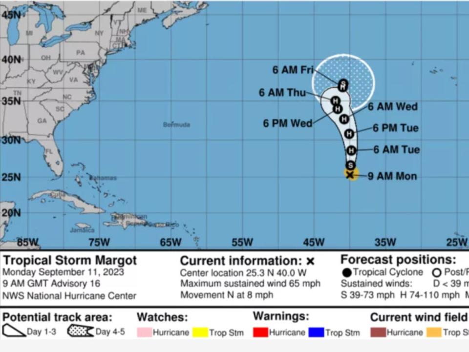
“At 900 AM GMT (0900 UTC), the center of Tropical Storm Margot was located near latitude 25.3 North, longitude 40.0 West. Margot is moving toward the north near 8 mph (13 km/h), and this general motion is expected to continue during the next several days,” the National Hurricane Centre said in an advisory.
Forecasters are expecting it to gain strength over the next 48 hours. The storm’s winds are currently peaking around 65mph (104km/h).
READ MORE:
Tropical Storm Margot expected to become hurricane tonight as path remains uncertain
Hurricane Lee’s late-week impact on US east coast, Canada, still unknown
Monday 11 September 2023 16:27 , Graig Graziosi
Hurricane’s Lee’s potential late-week impact on the US east coast and Canada is still unknown, according to the National Hurricane Centre.
“It remains too soon to know what level of impacts, if any, Lee might have along the U.S. East Coast and Atlantic Canada late this week, especially since the hurricane is expected to slow down considerably over the southwestern Atlantic,” the centre said on Monday.
It did note, however, that high surf and rip currents were still likely along the coast.
Heavy rains and high surf possible risk for Bermuda this week
Monday 11 September 2023 15:27 , Graig Graziosi
Hurricane Lee may bring heavy rains, strong winds, and high surf to Bermuda later this week as it continues its journey through the Atlantic basin and along the US east coast.
“Lee could bring wind, rainfall, and high surf impacts to Bermuda later this week. Although it is too soon to determine the specific timing and level of those impacts, interests on Bermuda should monitor the latest forecasts for Lee,” the National Hurricane Centre said in a report.
Hurricane Lee is expected to gradually shift north by the middle of the week.
Hurricane Lee: Latest National Hurricane Centre report says storm should begin to swing north by midweek
Monday 11 September 2023 14:45 , Graig Graziosi
Hurricane Lee continued churning in the Atlantic on Monday after reaching its peak as a Category 5 storm on Thursday.
The National Hurricane Centre reports that Hurricane Lee is producing maximum sustained winds of 120mph (195km/h) — a Category 3 hurricane — and is on a northwesterly trajectory moving at 7mph (11km/h).
The centre believes Hurricane Lee will continue taking a "slow" path toward the west-northwest over the next few days before turning gradually north by the middle of the week.
The storm is expected to pass well north of the Virgin Islands and Puerto Rico. It is currently approximately 340 miles (545km) north of the Northern Leeward Islands and approximately 650 miles (1045km) south-southeast of Bermuda.
We’re in the ‘peak’ of Atlantic hurricane season
Monday 11 September 2023 14:00 , Alex Woodward
Sunday’s climatological peak of the Atlantic hurricane season – with conditions ripe for tropical storms and hurricanes – saw considerable action, with a strengthening Category 3 hurricane and soon-to-be hurricane tracking closely together, followed by two brewing systems to their west.
The “peak” date typically sees ocean waters at their highest temperatures, peak intensity in the atmosphere to generate thunderstorms, and shearing winds that can suffocate storms declining to a minimum, which tropical waves that fuel storms in the summer continue well into September.

