Hurricane Lee's waves, ferry cancelations and no damage: What we see on the SouthCoast
As of 5 a.m. Saturday, Sept. 16, Hurricane Lee, now post-tropical cyclone Lee, is moving north off the coast of Cape Cod Massachusetts, bringing possible hurricane conditions to southern New Brunswick and Nova Scotia later today and into tomorrow.
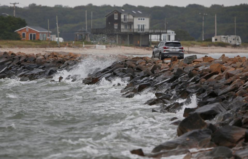
At Horseneck Beach the surf was fairly calm and a few cars were passing to look at the conditions as of 8 a.m. The wind was calm at Padanamaram in Dartmouth as well.

On Saturday morning, Fall River Mayor Paul Coogan, said he "was already out and about" had just checked in at the Department of Community Maintenance barn on Lewiston Street.
"So there have been no calls to Lewiston Street. We have been prepared to go, but so far no reports of trees down, no calls for anything important. So we have skated by this one and we are pretty calm right now," he added.
What happened overnight?
Area police and fire departments reported a quiet night. New Bedford, Fairhaven, Dartmouth, Mattapoisett, and Marion officials said they didn't have any storm-related problems to report overnight. There were also no power outages recorded in any of the communities, according to the Eversource website.

The Boston weather service office said the region did not experience a lot of coastal flooding with the early morning high tide, but did experience minor flooding in Nantucket Harbor and some "splashover" in Scituate. A Canadian buoy to the east of Lee's center, roughly 350 miles east of Boston, has reported wave heights ramping up from 20 at 1 a.m. to 36 feet by 8 a.m.
Track the storm: Follow Hurricane Lee's path with our tracker. Storm to bring rip currents, storm surge
Where is Hurricane Lee now and how strong is it?
Per the National Hurricane Center's 5 a.m. forecast discussion, Hurricane Lee "completed its transition to a post-tropical cyclone" overnight, forming into a comma-shaped storm lacking the convection and organization of a tropical storm or hurricane.
However, the NHC notes that Lee remains a "potent" storm, with winds measuring up to 75 mph recorded 110 miles from its center.
Lee is traveling north, outside of the Gulf Stream, at about 25 mph.
Several trees have been reported down in Washington County, Maine, the National Weather Service office in Caribou, Maine reported. Gusts up to 80 mph were reported on Grand Manan Island, a Canadian island just offshore of Washington County where the Gulf of Maine becomes the Bay of Fundy.
'Sobering' data: US has set a record for natural disasters and climate catastrophes in 2023
Is the Seastreak Ferry running today?
Seastreak Ferries has cancelled all service between New Bedford, Martha's Vineyard and Nantucket today, and all Martha’s Vineyard service will be diverted to Vineyard Haven on Sunday.
Sunday's diverted schedule includes:
8:45 a.m. New Bedford departure will arrive in Vineyard Haven, not Oak Bluffs; 12:30 p.m. Martha’s Vineyard departure will depart from Vineyard Haven, not Oak Bluffs; 2 p.m. New Bedford departure will arrive in Vineyard Haven, not Oak Bluffs; 5:30 p.m. Martha’s Vineyard departure will depart from Vineyard Haven, not Oak Bluffs
The address for the Vineyard Haven dock is 1 Water St., Vineyard Haven.
Questions can be directed to 1-800-BOATRIDE (262-8743), or via email at contactnb@seastreak.com.
Block Island Ferry cancels high speed ferry Saturday, adjusts traditional ferry schedule
According to the Block Island Ferry website, all high speed ferry departures have been cancelled for Saturday, Sept. 16.
The ferry service also cancelled the 8:15 a.m. traditional ferry departing Block Island and 9 a.m. traditional ferry departing Pt. Judith.
Traditional ferry service will resume from Block Island and Pt. Judith starting at 11 a.m., according to the website.
Is Hurricane Lee causing flight delays at T.F. Green?
As of 8 a.m. Saturday morning, flights into and out of Rhode Island T.F. Green International Airport remain largely unaffected by Hurricane Lee.
The flight tracker on the airport's website shows all flights scheduled for the day running on time.
State of Emergency declared in Massachusetts ahead of Hurricane Lee to help with response
Gov. Maura Healey declared a state of emergency in Massachusetts on Friday and is requesting that FEMA issue a pre-disaster emergency declaration. A state of emergency and an emergency declaration makes Massachusetts eligible for direct federal assistance for response costs, personnel, equipment, supplies and evacuation assistance.
Healey activated 50 National Guard troops for storm preparation and to be prepared to respond with high-water vehicles if needed.

The Massachusetts Emergency Management Agency opened its state of emergency operation center at its Framingham headquarters at 7 a.m. The state will also set up operation centers in Franklin and Tewksbury to support local and state agencies and organizations.
The Massachusetts Department of Transportation has urged residents to stay off the roads in the height of the storm.
~ Kinga Borondy, Massachusetts Statehouse reporter with the Worcester Telegram.
Power outage estimates: Affects could be 'minor to moderate'
Carl Sawejko, coordinator of Emergency Management Services for Swansea, was on the statewide briefing coordinated by MEMA and the National Weather Service at 3 p.m. Friday.
Sawejko said that storm officials anticipated that affects of the storm will likely be minor to moderate, and wind gusts could peak early Saturday.
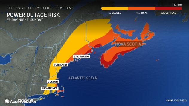
Storm officials also indicated, according to Sawejko, that utility company Eversource anticipates that at the peak of the storm 140,000 could be impacted with National Grid estimating that at the height, 139,000 of its customers could be impacted.
To report an outage to Eversource, call 800-592-2000; to report an outage to National Grid, call 800-465-1212.
Making plans for Nigel: National Hurricane Center tracking tropical depression expected to become hurricane soon
Looking ahead: Could another tropical storm follow Lee? Accuweather thinks so
The National Hurricane Center is currently tracking a tropical depression that formed in the Atlantic. It is expected to become a tropical storm Saturday, and could become a hurricane late this weekend. The developing storm will likely be named Nigel, unless something else pops up very soon ahead of it to grab the next name on this year's list.
The storm could follow a path similar to that Hurricane Lee's over the past week, according to AccuWeather.
The National Hurricane Center is predicting maximum sustained winds could reach 120 mph in four days, making it a Category 3 storm. And that's a conservative estimate, forecasters said.
— Cheryl McCloud, USA Today Network
Emergency numbers to know:
To report a downed power line, medical, fire, or other emergencies, dial 911
Eversource: 800-592-2000
National Grid: 800-465-1212
Verizon: 800-VERIZON
Comcast: 800-XFINITY
Police non-emergency lines:
Acushnet: 508-998-0240
Dartmouth: 508-910-1700
Fairhaven: 508-997-7421
Fall River: 508-676-8511
Freetown: 508-763-4017
New Bedford: 508-991-6350
Somerset: 508-679-2138
Swansea: 508-674-8464
Westport: 508-636-1122
New Bedford Department of Public Infrastructure: 508-979-1550
Fall River Department of Community Maintenance: for downed trees or branches, 508-324-2762; for sewer/storm drain flooding, 508-672-4530; for Water Department-related issues, 508-324-2721
This article originally appeared on The Herald News: New Bedford and Fall River weather: Hurricane Lee's rain, high surf
