Tropical storm watch in effect for Bermuda as Hurricane Lee approaches. Will it hit NJ?
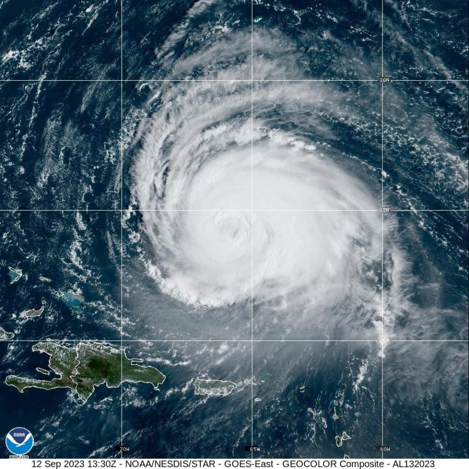
A tropical storm watch was in effect Tuesday afternoon for Bermuda as Hurricane Lee remained a large and powerful storm, causing dangerous surf and rip currents along the southeastern U.S. coast. Similar conditions should be felt along the New Jersey shore later in the week as the storm starts to make its move northwards, National Weather Service forecasters said.
Lee was still a major Category 3 hurricane Tuesday afternoon, with sustained winds of 115 mph and even stronger gusts. Forecasters expect little change in strength over the next day or two, followed by gradual weakening.
Tropical storm winds should be felt on Bermuda by Thursday morning.
UPDATE Will Hurricane Lee hit the East Coast? The latest on the storm's likely impact for NJ
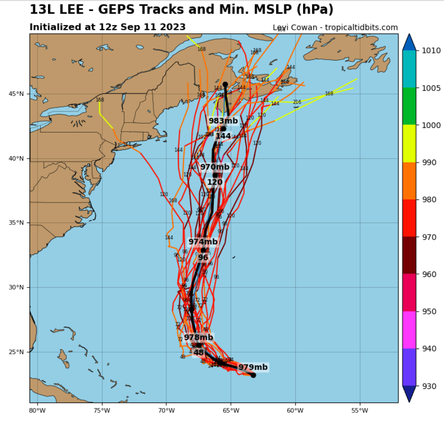
Most models are currently in agreement, showing Lee's likely path will shift north by midweek, avoiding the New Jersey and New York area, but eventually making landfall somewhere in the Maritime provinces of eastern Canada.
It should pass a little to the west of Bermuda this week, and Lee's winds should reach the Atlantic east of New Jersey by Friday morning, according to the National Hurricane Center.
Lee was moving northwest at 6 mph about 545 miles south of Bermuda Tuesday morning, and remained large, with hurricane force winds extending 90 miles out from the center and tropical storm force winds extending 205 miles out.
When is Hurricane Lee supposed to impact NJ? And how?
While the modeling Monday remained consistent on likely landfall in eastern Canada, one extreme outlier model that's part of the ensemble of possible paths produced by the National Oceanic and Atmospheric Administration has Lee shift suddenly to the northwest, making landfall around Sandy Hook and barreling right up into New York Harbor and the Meadowlands region of Bergen County. By Tuesday that model no longer showed the hurricane hitting the New York region.
Three other outlier paths show Lee slamming into the Martha's Vineyard and Cape Cod region of Massachusetts.
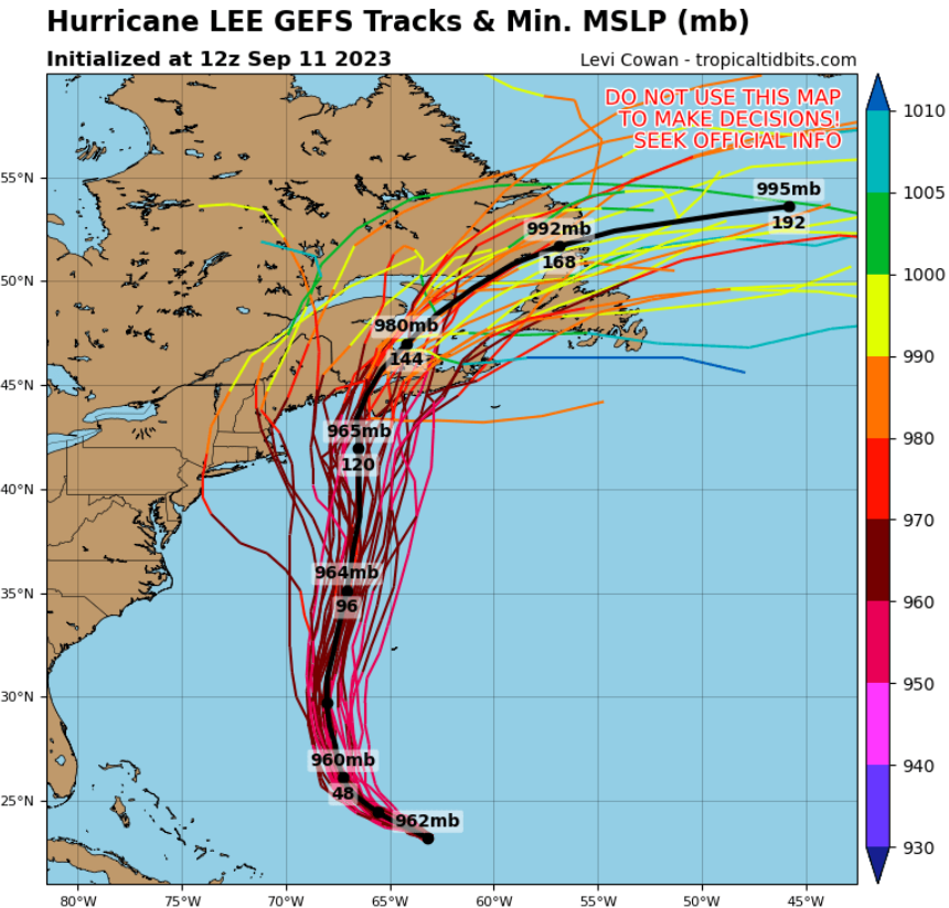
Another outlier model, part of the ensemble produced by the European Centre for Medium-Range Weather Forecasts, shows Lee making landfall in the posh Hamptons of eastern Long Island, cutting across Long Island Sound and then heading into upstate New York.
"When you see an outlier, that's showing the outside envelope of what could happen," said John Scala, a certified consulting meteorologist and instructor for the Federal Emergency Management Agency. "We don't completely discount it, but it's a very low probability."
Obviously, as modelers receive new data on Lee's actual behavior, they update their models and the possible storm paths could change.
Hurricane Lee projected path could veer away from the East Coast
Most of the models show Lee eventually shifting course to the north because a trough, or upper level disturbance, is expected to arrive, which would help the mid-latitude westerly winds push Hurricane Lee away from the East Coast, said Steven Decker, an expert on weather analysis and forecasting at Rutgers University.
More: How do they make those hurricane modeling charts? And what do they predict for Lee?
So the models are trying to account for the trough's future arrival by showing Lee's path shift north, Scala said.
How quickly the trough arrives and how strong it is will help determine Lee's ultimate path, Decker said.
Swells generated by Lee with the potential to create life-threatening rip currents are affecting portions of the Lesser Antilles, the British and U.S. Virgin Islands, Puerto Rico, Hispaniola, the Turks and Caicos Islands, the Bahamas, and Bermuda, according to the National Hurricane Center.
This article originally appeared on NorthJersey.com: Hurricane Lee to hit NJ with dangerous rip currents as it moves north

