Hurricane Lee path tracker, spaghetti models: New Hampshire could see tropical storm-force winds
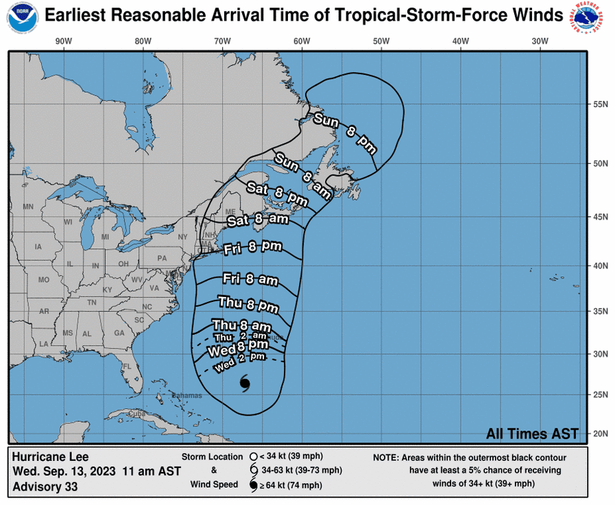
Hurricane Lee continued to move northwest over the Atlantic Ocean with sustained winds near 115 miles per hour Wednesday morning as it heads toward the coasts of Maine and eastern Canada, according to the latest advisory from the National Hurricane Center.
Lee, which has remained a Category 3 major hurricane, is forecast to weaken into a tropical storm by Sunday before the storm’s center reaches the coast of Maine, New Brunswick or Nova Scotia, the hurricane center said.
The National Hurricane Center projected Wednesday that New Hampshire and other parts of New England could be looking at tropical-storm force winds, 39 mph or greater, as early as Friday night.
“Dangerous surf and life-threatening rip currents” will affect parts of the northern Leeward Islands, Virgin Islands, Puerto Rico, Hispaniola, the Turks and Caicos Islands, Bahamas, Bermuda and most of the U.S. East Coast this week, according to the hurricane center.
Hurricane Lee: With Hurricane Lee on the move, Cape Cod harbormasters advise mariners to prepare, in case
Latest updates from USA TODAY: Hurricane Lee's projected path to bring big surf, dangerous currents to US East Coast
As forecasters continue to monitor Lee, those at the National Hurricane Center as well as at AccuWeather agree it's a storm New Englanders should keep an eye on.
The NH Homeland Security and Emergency Management has not issued any warnings regarding Hurricane Lee, saying its proximity to New England remains uncertain.
"While building waves and hazardous surf are expected, it is too early to determine if there will be any other significant impacts to western Maine and New Hampshire," said the emergency management body.
Meanwhile, the state is expected to experience moderate rains with pockets of heavy rain and thunderstorms.
Hurricane Lee projected path
This forecast track shows the most likely path of the center of the storm, but does not illustrate the full width of the storm or its impacts. The center of the storm is likely to travel outside the cone up to 33% of the time.
Hurricane Lee spaghetti models
Model plot illustrations include an array of forecast tools and models, and not all are created equal. The hurricane center uses the top four or five highest-performing models to help make its forecasts.
Contributing: USA TODAY staff
This article originally appeared on USA TODAY: Hurricane Lee tracker: New Hampshire encouraged to watch path, models

