Hurricane Lee path tracker, spaghetti models: Rhode Island could see tropical storm-force winds
Category 3 Hurricane Lee, with sustained winds near 115 miles per hour, remains a large and powerful hurricane that projects to be heading towards the coasts of Maine and eastern Canada, said the National Hurricane Center Wednesday.
Lee, which has remained a Category 3 major hurricane, is forecast to weaken into a tropical storm by Sunday before the storm’s center reaches the coast of Maine, New Brunswick or Nova Scotia, the hurricane center said.
“Dangerous surf and life-threatening rip currents” will affect parts of the northern Leeward Islands, Virgin Islands, Puerto Rico, Hispaniola, the Turks and Caicos Islands, Bahamas, Bermuda and most of the U.S. East Coast this week, according to the hurricane center.
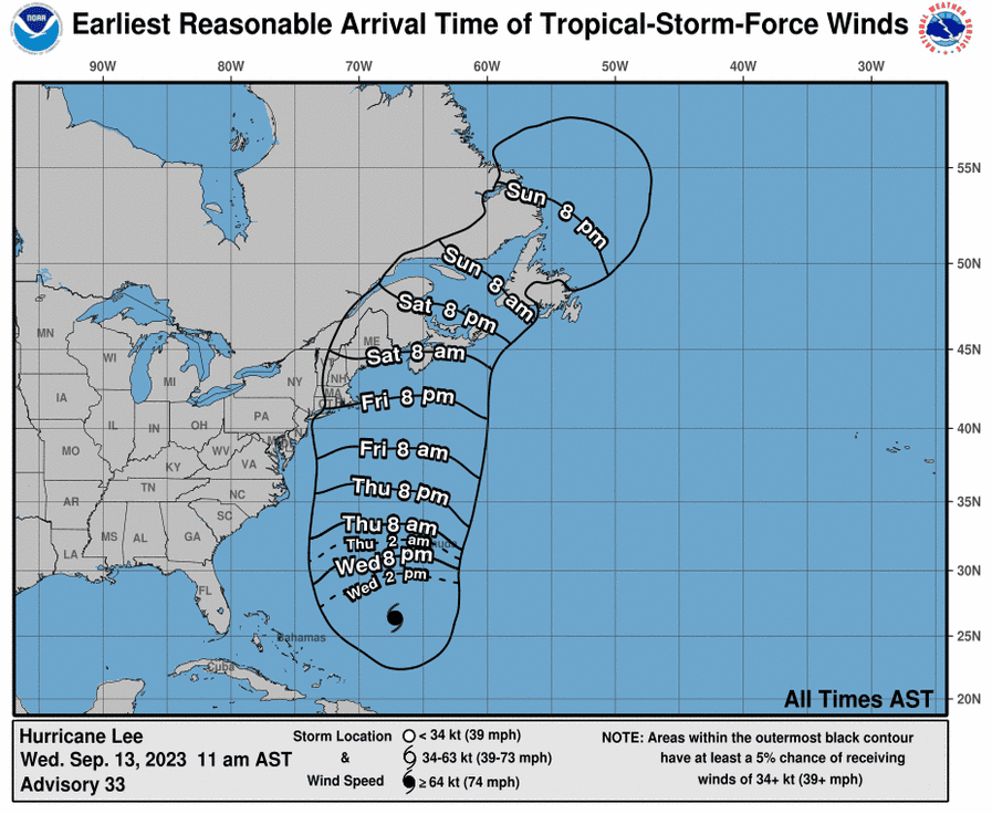
A National Hurricane Center graphic shows Rhode Island, eastern Massachusetts and eastern Connecticut potentially getting tropical-storm force winds, 39 mph or greater, as early as Friday night.
AccuWeather predicts Lee is most likely to make landfall in Nova Scotia, Canada, this weekend but could be pulled west toward New England or pushed east toward Newfoundland and Labrador.
Hurricane Lee: With Lee on the move, Cape Cod harbormasters advise mariners to prepare, in case
Latest updates from USA TODAY: Hurricane Lee's projected path to bring big surf, dangerous currents to US East Coast
As forecasters continue to monitor Lee, those at the National Hurricane Center as well as at AccuWeather, agree it's a storm New Englanders should keep an eye on.
The National Weather Service warned of high rip current risk on Rhode Island and Massachusetts beaches Wednesday.
Look back: NOAA predicts a busy hurricane season. Take a look back at 7 big New England storms
Hurricane Lee projected path
This forecast track shows the most likely path of the center of the storm but does not illustrate the full width of the storm or its impacts. The center of the storm is likely to travel outside the cone up to 33% of the time.
Hurricane Lee spaghetti models
Model plot illustrations include an array of forecast tools and models, and not all are created equal. The hurricane center uses the top four or five highest-performing models to help make its forecasts.
This article originally appeared on USA TODAY: Hurricane Lee tracker, model: Rhode Island urged to watch path updates

