Hurricane Lee drops to Category 3 after building to Cat 5; S. Fla. impacts not expected
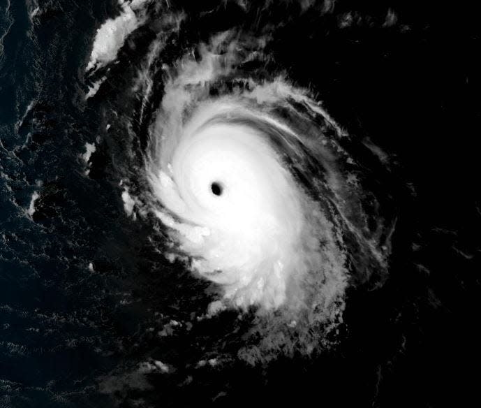
Hurricane Lee reached the epitome of tropical cyclone royalty late Thursday — a brutal and beautiful, remorseless and uncontainable Category 5 with winds expected to remain at major-hurricane strength for at least the next five days.
The National Hurricane Center dropped Lee’s intensity to a Cat 4 early Friday, noting that it may fluctuate over the coming days, as super-hurricanes are capricious in nature.
By the grace of an invisible dip of frigid winds from Canada, South Florida has been promised amnesty from Lee’s pure wrath.
The storm, which has defied even the most extreme wind speed expectations, is predicted to zip around the western edge of the Bermuda High with a boost from the diving jet stream over the U.S. Working together, the two forces will help steer Lee away from the Sunshine State beginning in the middle of next week.
As of 11 a.m. today, Lee had dropped to a Category 3 storm, but forecasts were calling for it to regain intensity in the coming days. The storm was about 350 miles east of the Lesser Antilles and packing maximum winds of 115 mph.
More storms for Florida?: AccuWeather updates forecast, predicting 3-5 major hurricanes in 2023 season
The impact Hurricane Lee may have on Palm Beach County
Meteorologist Barry Baxter of the National Weather Service said today forecasters don’t expect South Florida to be impacted by the hurricane, because the storm is too far east. While communities in north and central Florida may experience swells and rip currents, Baxter said the same is not true of South Florida because it’s protected by the Bahamas.
In the Treasure Coast, NWS meteorologist Zach Law said seas will start building Sunday and steadily increase through the week to 8-9 feet offshore.
At the coast, wave heights could reach 6 feet. He’s expecting dangerous rip currents and heavy erosion.
“At this time, there is pretty good model agreement, but, again, once you start getting long-term, the confidence gets low,” Law said. “Regardless, we are entering peak hurricane season, so it’s always good to have your hurricane preparations in place.”
The peak of hurricane season lasts from about mid-August through mid-October with Sunday, Sept. 10, as the pinnacle.
That put Lee in the right spot for ripening, although as the third major hurricane of Category 3 or higher this season, it is 51 days ahead of climatology, said Brian McNoldy, a hurricane researcher at the University of Miami Rosenstiel School of Marine Atmospheric and Earth Sciences.
“Turns out that hurricanes like 30-31 degrees Celsius (86-88 degrees Fahrenheit) ocean temperatures,” he said jokingly in a social media post.
Hurricane Lee strengthened by 80 mph in a day: Current path of storm
Over those record-warm waters in the main runway between Africa and the Caribbean, Lee was able to strengthen by a remarkable 80 mph in just 24 hours.
On Wednesday at 11 p.m., it was a Category 1, 80 mph hurricane. By Thursday at 11 p.m., it was a Category 5 storm with 160 mph winds. By 8 a.m. Friday, sustained winds were up to 165 mph.
The definition of rapid intensification is 35 mph in 24 hours or less.
“Comparisons being thrown out there are to Hurricane Wilma, which really topped the scales in terms of fastest intensification in a major Cat 5,” said Brandon Buckingham, a meteorologist with AccuWeather. “We knew it was going into an area ripe for development and we were forecasting a Cat 5, but we didn’t expect 80 mph strengthening in 24 hours.”
Six other Atlantic hurricanes in the satellite era have intensified by 80 mph or higher, according to Colorado State University hurricane expert Phil Klotzbach. Those include Wilma (2005), Felix (2007), Ike (2008), Matthew (2016), Maria (2017) and Eta (2020.)
“It’s fairly rare to see a storm reach Cat 5 strength,” Buckingham said. “There are only a few that have made it there.”
Hurricane Wilma reached sustained wind speeds of 185 mph on Oct. 19, 2005, after a rapid intensification that had it gaining 98 mph in 24 hours. It made landfall Oct. 24 on the southwest coast of Florida as a Cat 3 storm and reached western Palm Beach County as a Category 2.
Wilma shredded South Florida: Meteorologists remain astonished by the deadly late season surprise
Bryan Norcross, the hurricane specialist for Fox Weather, said Lee’s feverish increase to a Cat 5 also reminded him of 1992’s Hurricane Andrew.
“We weren’t expecting that super intensification Thursday,” Norcross said about Lee. “It wasn’t supposed to happen until the weekend.”
The most intense storms can also be unpredictable. Eyewall replacement cycles — where a storm’s contracting eyewall is overtaken by an outer ring of thunderstorms — can temporarily weaken a hurricane.
And those cycles are difficult to forecast.
“This is going to be, and is, a super-powerful storm,” Norcross said about Lee. “And it will stay that way for several days.”
Kimberly Miller is a veteran journalist for The Palm Beach Post, part of the USA Today Network of Florida. She covers real estate and how growth affects South Florida's environment. Subscribe to The Dirt for a weekly real estate roundup. If you have news tips, please send them to kmiller@pbpost.com. Help support our local journalism, subscribe today.
This article originally appeared on Palm Beach Post: Hurricane Lee's path, spaghetti models, impact on Florida

