Hurricane Lee's impact: NH Seacoast, Maine to see tropical storm force winds, high waves
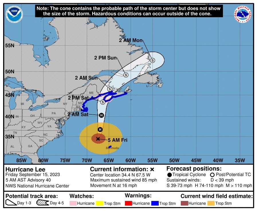
Hurricane Lee has weakened and its path is moving eastward, but its impact is still expected to affect Seacoast New Hampshire and southern Maine. A tropical storm warning remains in effect locally, according to the National Weather Service in Gray, Maine.
After dropping to a Category 1 storm earlier in the day, Lee was stirring off the coast of Virginia and traveling northbound on Friday afternoon. The National Hurricane Center reported that around 2 p.m., the system was about 340 miles south-southeast of Nantucket moving at 18 miles per hour.
“On the forecast track, the center of Lee will continue to move farther away from Bermuda and approach the coast of New England and Atlantic Canada through Saturday,” the National Hurricane Center said. “Lee is then expected to turn toward the north-northeast and northeast and move across Atlantic Canada Saturday night and Sunday.”
The hurricane was last measured as having 80-mile-per-hour maximum sustained wind speeds, and coastal New Hampshire and Maine are under tropical storm advisories. The latest update from the National Hurricane Center showed that Lee's hurricane-force winds extend outward up to 105 miles, while its tropical storm-force winds can be felt up to 320 miles away.
Downeast Maine had a hurricane watch in effect as recently as Friday morning, though the National Weather Service has since downgraded it to a tropical storm watch.
Joining Hurricane Lee in the Atlantic Ocean is the simultaneous Tropical Storm Margot, which late Friday morning was roughly 625 miles west of the Azores.
Nikki Becker, a National Weather Service meteorologist stationed in Gray, Maine, noted Friday afternoon that Hurricane Lee is expected to make landfall in Nova Scotia on Saturday night around 8 p.m. The system at that point is projected to lessen to a tropical storm.
"Hoping for best": Southern Maine coast prepares for Hurricane Lee
What the storm's impact looks like in Seacoast NH and southern Maine
Hurricane Lee’s track has moved east over the last few days, decreasing expected rainfall, wind speeds and coastal flooding in the Seacoast New Hampshire and in southern Maine. Its ripple effects will still be felt throughout the region, however, and could lead to scattered power outages.
NH power outage map: Track the latest information here
Hurricane Lee is not anticipated to bring much rain to area communities, though the coast is currently under a high surf advisory and a coastal flooding advisory. Later Friday night, a wind advisory will take effect for much of the area.

Sustained winds of about 10 to 20 miles per hour are expected along the coastline Friday night, with gusts reaching 35 miles per hour. Sea swells on Friday night could range between five and nine feet high with potential splash over.
Beginning Friday night, according to Becker, slight rainfall is expected to begin, which would strengthen to on-and-off showers Saturday morning into early afternoon.
On Saturday, the coastline may experience winds of 25 to 35 miles per hour, with gusts hitting 45 miles per hour. Sea swells on Saturday may stretch to between 12 and 18 feet high, creating larger splash overs.
Rainfall, wind speeds and possible flooding risks increase further north into Maine, Becker added.
Maine power outage map: Track the latest information here
“We’re actually not expecting that much precipitation in most of our forecast (area),” she said. “We’re looking at around a few tenths (of an inch) to about a half inch, and it’s going to be higher the more north you go. It will be the same thing with the (sea) swells and the coastal flooding.”
Possible coastal flooding would not come from the anticipated minimal rainfall, though could be the result of Lee’s high winds and sea swells combining with Margot’s tropical storm winds.
Temperatures in the low 70s are expected locally Saturday. The storm is forecast to wind down starting Saturday evening locally. Sunny weather with temperatures in the mid- to upper 70s is forecast Sunday.
Stay connected: Seacoastonline, Foster's apps give you best access to local breaking news
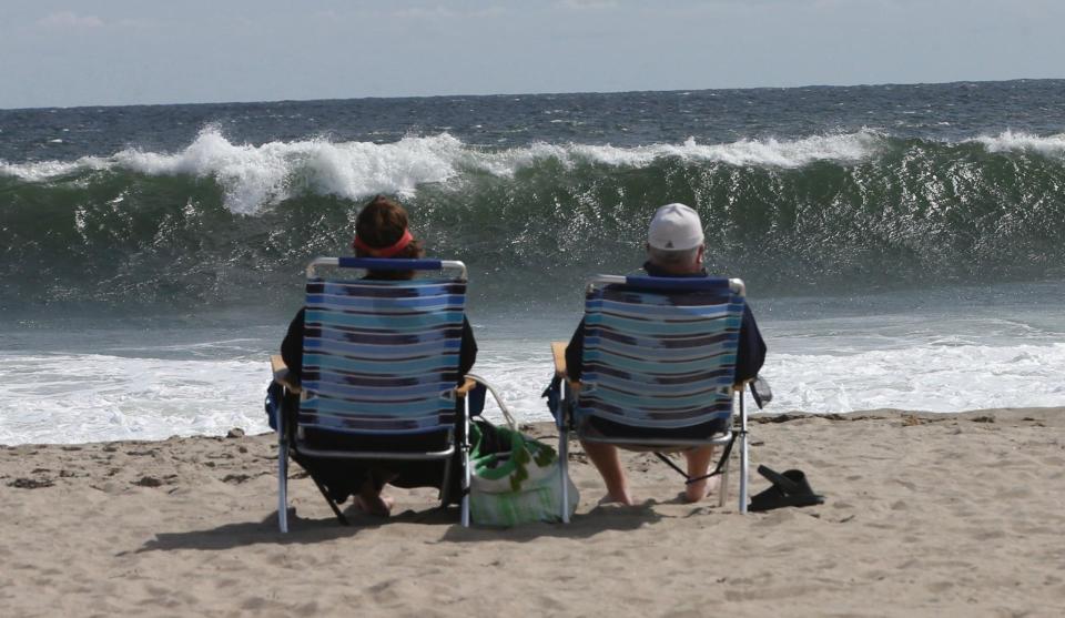
What will waves look like at Seacoast NH and southern Maine beaches?
The National Weather Service has a high surf advisory issued for the New Hampshire and Maine coasts. Swimmers are being warned against going in the water with rip currents expected.
Watch live: Here are web cams from Hampton Beach, Rye and southern Maine beaches
"It’s like surfing in Hawaii": NH surfers are making the most of Hurricane Lee’s waves
Swimmers warned: Hampton Beach lifeguards warn of 'flash' rip currents and high waves from Hurricane Lee
Coast Guard warns boaters
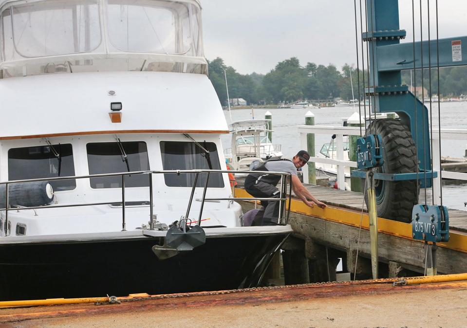
The Coast Guard issued a statement urging caution for boaters as Hurricane Lee moves northward.
"Do not go to sea in a recreational boat to 'ride out' a hurricane," the Coast Guard's statement says in part. "All mariners should stay off the water."
NH impact: Hurricane Lee path tracker, spaghetti models
The Coast Guard also offered more safety advice, including:
If you cannot evade a storm, wear a life jacket and know how to activate your distress signaling devices. Rescue and assistance by the Coast Guard and other agencies, however, may be severely degraded or unavailable immediately before, during and after a devastating storm.
If you are in a vessel and see signs of bad weather, seek shelter. While en route to shelter, tie down loose objects on the boat and prepare passengers for possible rough water, heavy rains and high winds. Have all aboard put on life jackets, including pets. Do not let passengers below deck remove their life jackets.
If you think the boat may sink or capsize, keeping passengers above deck and attached to safety lines may be best.
If you get into trouble, call for help immediately.
How Seacoast NH and southern Maine towns are preparing
The town of New Castle is closing down Great Island Common and the town beach to pedestrians beginning Friday evening as Hurricane Lee closes in, in addition to nearby Fort Stark.
The grassy, rocky common is a popular spot for photographers to snap pictures of weather events, passing submarines heading to the Portsmouth Naval Shipyard and large boats traversing through the area.
The closure will begin at 9 p.m. Friday and won’t be lifted until the town’s fire or police chief deem it appropriate.
“Large rocks and debris are blown (and) washed far from the edge of the shore and can cause serious bodily injury,” wrote New Castle Fire Chief and Emergency Management Director Ted Hartmann in a public notice. “Injured or trapped persons (and) vehicles place additional burdens on emergency services. If you fall into the ocean limited measures can be taken during the severe weather.”
December 2022 storms, which wreaked havoc on local communities by causing flooding and widespread power outages, drew photographers and onlookers to Fort Stark. Hartmann wrote that rocks the size of softballs at Fort Stark were flung through the air due to winds in those storms.
Additionally, being closed on Friday night in New Castle is the beach access and parking area at the end of Ocean Street.
“It is not worth the risk to capture a picture or feel the force of the wind,” Hartmann added.
Portsmouth cancels recreational soccer, farmers' market
New Castle’s neighbor, Portsmouth, noted in a citywide hurricane alert that its public safety staff will be monitoring the storm, though the city does not anticipate major impacts this weekend.
Still, the city shared that the Portsmouth Recreation Department has canceled soccer on Saturday, and Seacoast Eat Local has called off its regular farmers’ market.
“There is the potential for life-threatening storm surge, rip currents and dangerous surf,” Portsmouth’s notice states. “Expect high winds. “Rainfall may produce localized urban, coastal, and small stream flooding from Friday night into Saturday.”
Kittery, Maine issues advisories, closes pier and parking
Across the bridge, leaders in Kittery, Maine advised residents to remove their dinghies from the Pepperrell Cove docks by Thursday at 7 p.m. in order for town harbormaster John Brosnihan to finish preparation for the storm. The town warned that anyone who doesn’t remove their dinghies could lose mooring privileges or be fined.
Projected storm surge is causing the town to close the Pepperrell Cove pier and parking lot at 8 p.m. Friday until the storm ends.
Kittery advised residents to steer clear of Fort Foster and Seapoint Beach during the storm.
“Accessing these sites increases the risk of injury or need for rescue if you are stranded or swept out with the waves,” the town wrote in an alert on Thursday. “Our public safety personnel will be actively addressing storm impacts all over town during this storm. By staying away from highly impacted, risky areas, you can help make their jobs significantly easier.”
York, Maine to close coastal roads and beaches
The town of York, Maine, announced Friday they are expecting closures of low-lying coastal roads (Long Beach Avenue, Ocean Avenue and potentially others) due to forecasted storm surge and coastal splash-over on Saturday.
The town also has ordered the closure of all beaches (including bathhouses/restrooms) from midnight on Saturday, Sept. 16 to midnight on Sunday, Sept. 17.
Kennebunkport, Kennebunk and Wells, Maine brace for impact
In Kennebunkport, the town announced that the Public Works Department would be placing large rocks at the foot-path entrances at Goose Rocks Beach to help mitigate the potential storm damage and clean-up.
“This will be a temporary measure and will be moved as soon as appropriate,” the town said.
Kennebunkport temporarily opened its newly acquired public boat launch on Langsford Road to allow people to take their boats out of the water, ahead of the storm and without the need for a reservation.
On its website, the town of Kennebunk alerted residents that public service employees are in the process of removing portable trash cans and toilets, benches, stairs, ramps and more from all beaches.
Similarly, the town of Wells issued an early advisory on its website, informing residents that efforts were underway to secure such coastline items as trash, receptacles, portable restrooms, and lifeguard stations. The town also is placing barricades throughout the community, in case road closures become necessary.
Hurricane Lee's impact on weekend events
The Alzheimer’s Association Maine Chapter announced Friday that the Maine Beaches Walk to End Alzheimer’s (York Beach) and Lakes & Mountains Walk to End Alzheimer’s (Lewiston) scheduled for Saturday, Sept. 16, are canceled due to weather concerns as Hurricane Lee approaches.
The Alzheimer’s Association is encouraging participants to continue to fundraise and invite others to donate online. Fundraising for the Walk to End Alzheimer's continues through the end of the calendar year.
The Mount A Challenge in York on Saturday has been postponed until Sept. 30. The Mount Agamenticus gate will be closed from sunset Friday, Sept. 15, through sunrise Sunday, Sept. 17.
The York Art Association has moved its annual Art in the Park event from Saturday, Sept. 16 to Sunday, Sept. 17. The event will take place from 10 a.m. to 5 p.m. at Moulton Park at 394 York St. in York.
This story will be updated.
This article originally appeared on Portsmouth Herald: Will Hurricane Lee hit NH, Maine? Wind, high waves, what to expect

