Like Hurricane Michael, Idalia was as big as Colorado. How storm's size compares to others
When the eye of Hurricane Idalia made landfall near Keaton Beach, Florida, about 7:45 a.m. Wednesday, Aug. 30, it was a powerful Category 3 storm − about as wide as the state of Colorado.
At the time, Idalia had sustained winds at 125 mph and was on a collision course with Florida's Big Bend, inside 65 miles from the state's capital, Tallahassee.
How does Idalia's size and width compare to other storms? Take a look.
How big is Hurricane Idalia?
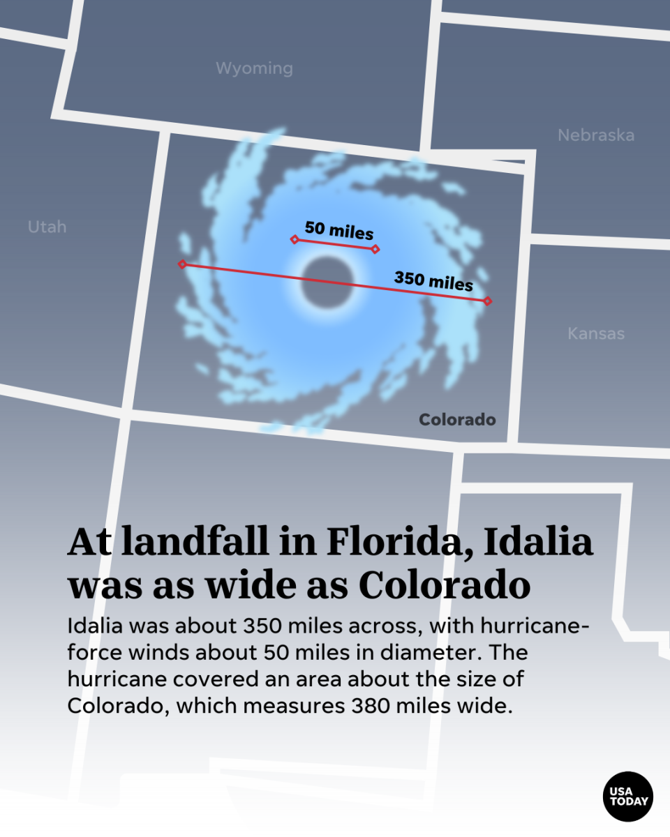
At 8 a.m. Wednesday, Aug. 30, the National Hurricane Center reported Idalia had hurricane-force winds extending "outward up to 25 miles from the center and tropical-storm-force winds extend outward up to 175 miles." That computes to about 350 miles across, with the hurricane-force winds about 50 miles in diameter, meaning Idalia covers an area about the size of Colorado, which measures 380 miles wide.
How big was Hurricane Sally?
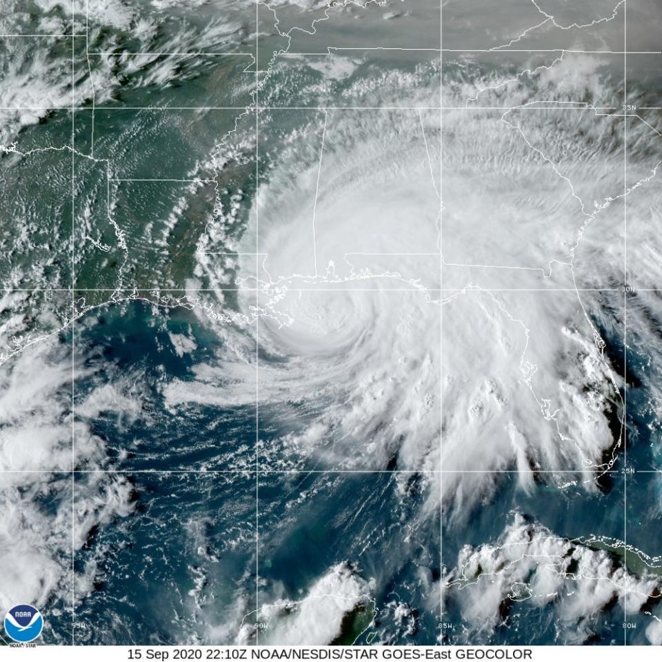
On Sept. 15, 2020, the National Hurricane Center reported hurricane-force winds extend outward up to 40 miles from the center and tropical-storm-force winds extend outward up to 125 miles, meaning Hurricane Sally was about 250 miles across. To compare, the state of Maryland is 250 miles long and 90 miles wide.
At the time, Sally's tropical storm-force wind field was 49,087 square miles. That's a little larger than the state of Mississippi. The hurricane-force wind field was about 5,026 square miles, which is slightly smaller than Connecticut.
Hurricane Sally made landfall Sept. 16, 2020, as a Category 2 storm near Gulf Shores, Alabama.
Hurricane Sally photos: Pensacola Beach, Quietwater Beach began flooding as storm inched closer
How big was Hurricane Dorian?
On Sept. 2, 2019, Labor Day, the National Hurricane Center reported Hurricane Dorian had hurricane-force winds that extend outward up to 45 miles from the center and tropical-storm-force winds that extend outward up to 140 miles. At the time, Hurricane Dorian was about 280 miles across, and its tropical storm-force wind field was 61,575 square miles. To compare, Florida measures 65,755 square miles, while neighboring state Georgia measures 59,425 square miles, meaning the Category 4 Dorian was smaller than Florida but slightly wider than Georgia.
Dorian made landfall at 12:40 p.m. Sept. 1, 2019, in Elbow Cay, Abacos, in the Bahamas as a Category 5 with 190 mph winds. The eye of Hurricane Dorian made a second landfall at 2 p.m. Sept. 1, 2019, on the Great Abaco Island near Marsh Harbour, according to the National Hurricane Center. Dorian was a Category 5 storm for a day before downgrading to a Category 4 on Sept. 2.
How big was Hurricane Michael?

On Oct. 9, 2018, the National Hurricane Center had reported Hurricane Michael's hurricane-force winds extended outward up to 45 miles from the center and tropical-storm-force winds extended outward up to 175 miles. Hurricane Michael was about 350 miles across, with the hurricane-force winds about 90 miles in diameter. On the day of landfall, Michael's tropical storm-force wind field was 96,211 square miles. That's a little smaller than the state of Colorado.
The hurricane-force wind field was about 6,361 square miles, which is about the size of Delaware.
Hurricane Michael made landfall at Mexico Beach as a dangerous Category 4 hurricane on Oct. 10, 2018.
How big was Hurricane Irma?

On Sept. 7, 2017, the National Weather Service estimated Hurricane Irma's diameter between 400 miles and 600 miles, making it twice as wide as the Florida peninsula. With winds exceeding 185 miles per hour and Irma's massive 400-mile wind field, the Category 5 storm was one of the most powerful hurricanes in recorded Atlantic Ocean history.
Several USA TODAY Network newspapers compared the size of Hurricane Irma with their home states:
The Palm Springs Desert Sun reported the storm was so big that Hurricane Irma could have engulfed the southern half of California – the third-largest state in America by landmass. It stretched 400 miles across, compared to the width of California which is only about 250 miles across. This image above was satellite footage from a wundermap of Hurricane Irma as it crossed over Caribbean islands overlaid on top of a scaled map of California.
The Reno Gazette Journal reported Hurricane Irma was larger than the width of Nevada, which measures about 310 miles at its largest width.
According to the Cincinnati Enquirer, when the storm became a Category 5 on Sept. 5, 2017, Irma clocked in at 392 miles long and 405 miles wide, Cleveland meteorologist JD Rudd said. That meant Irma was larger than the state of Ohio, which measures 220 miles long and 220 miles wide at its most distant points. On Sept. 6, the storm measured smaller at 364 miles wide as it barreled through the Leeward Islands of the Caribbean. But it would still easily cover Ohio. It also was big enough to cover most of the mitt of Michigan, eastern Indiana, northern Kentucky, western Pennsylvania and much of West Virginia. The effects of the storm would also have been felt in parts of Virginia, Maryland and New York if the storm was over Ohio, the Enquirer reported.
Hurricane Irma made landfall in Cudjoe Key, Florida, on Sept. 10, 2017, as a Category 4 storm.
How big was Hurricane Florence?
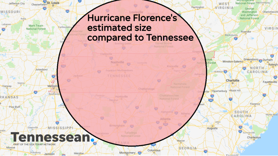
As of Sept. 10, 2018, Hurricane Florence was projected to have a diameter of 500 miles, making the storm nearly as long as Tennessee and four times as wide. The projected size and strength of Florence led to massive evacuations across the southeastern states in the path of the Category 4 storm.
The storm's 500-mile wingspan easily made Florence bigger than states such as Tennessee, Michigan and South Carolina.
Hurricane Florence made landfall near Wrightsville Beach (near Wilmington) in North Carolina at 7:15 a.m. Sept. 14, 2018, as a Category 1 storm.
How big was Hurricane Andrew?
Mention "Hurricane Andrew," and many Floridians will shudder. Though Hurricane Andrew was tiny, reaching a peak diameter of only about 200 miles, it devastated South Florida in 1992. The Category 5 storm killed 65 people in Florida in 1992, destroyed more than 63,500 homes and caused $26.5 billion in damage.
Contributing: Jeff Meesey and John Gallas, USA TODAY Network-Florida; Jill Castellano, Palm Springs Desert Sun; Sarah Litz, Reno Gazette Journal; Mallorie Sullivan, Cincinnati Enquirer
Sangalang is a lead digital producer for USA TODAY Network-Florida. Follow her on Twitter or Instagram at @byjensangalang. Support local journalism. Consider subscribing to a Florida newspaper.
This article originally appeared on Florida Today: How strong was Hurricane Idalia after Keaton Beach, Florida, landfall?

