Hurricane Nicole Live Updates: Duval Schools to close on Thursday
The Florida Times-Union has made this article free of charge for all readers in the interest of public safety. Please consider supporting local journalism with a digital subscription.
Duval, St. Johns and Clay County district schools are closing Thursday as the storm nears.
Major events were also disrupted: The Jacksonville Fair is closed on Thursday and has reduced hours on Friday. The city's Veterans Day parade on Friday was canceled. Other closings were being announced late Tuesday.
Follow our live blog throughout the day for more updates.
Quick Northeast Florida Tropical Storm Nicole links:
Tropical Storm Nicole: See the latest forecast, tracking map
What's open? What we know about closings and cancellations in the Jacksonville area
Big events disrupted: Tropical Storm Nicole forces Jacksonville Fair, Cummer to alter hours
From Tuesday: Forecasts of winds, storm surge from Nicole prompt Jacksonville cancelations, closures
6 p.m. | Hurricane Nicole: National Hurricane Center announces storm reaches hurricane strength
Nicole has now reached hurricane strength, the National Hurricane Center announced at 6 p.m., issuing a special update statement.
A NOAA Hurricane Hunter plane found that the storm's sustained winds have increased to 75 miles per hour, reaching the hurricane threshold. The storm is now making landfall on Grand Bahama in the Bahamas, with its center just over 100 miles east of West Palm Beach.
5:20 p.m. | James Weldon Johnson Park closed through Monday
Another park update: James Weldon Johnson Park in downtown Jacksonville will be closed through Monday due to Tropical Storm Nicole.
5:05 p.m. | JaxPort closed, under Port Condition Zulu
JaxPort closed its gates at 5 p.m. due to Tropical Storm Nicole. The Coast Guard set Port Condition Zulu earlier Wednesday, which effectively closes the port.
Port officials plan to reopen the gates 6:30 a.m. Friday to conduct assessments, pending Coast Guard approval.
4:25 p.m. | Edward Waters University pushes back football finale
High school football in Jacksonville has already faced effects from Tropical Storm Nicole, and now college football is also making adjustments. Edward Waters University is pushing back the start of its season finale against Allen University from 2 p.m. to 6 p.m. Saturday.
4 p.m. | The latest numbers to know
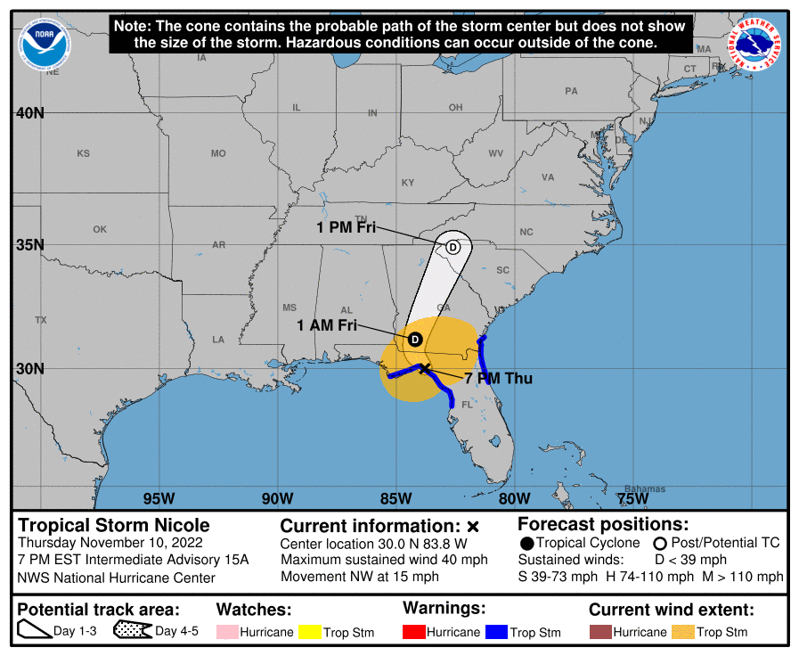
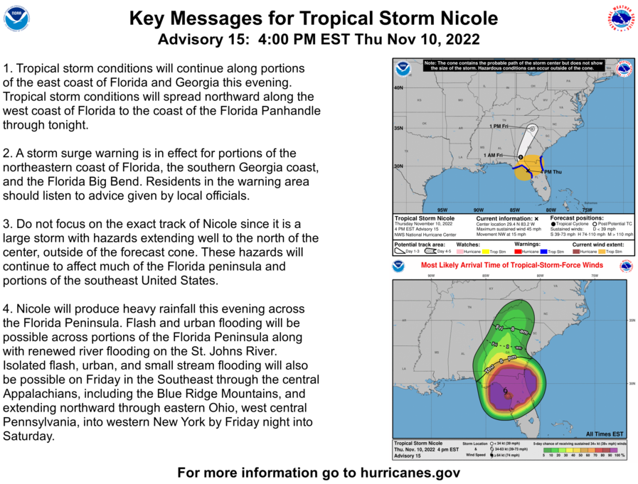
The National Hurricane Center issued its 4 p.m. advisory on Tropical Storm Nicole, which remains just below the threshold for hurricane force as it batters the Bahamas. A few key numbers to know from the 4 p.m. advisory:
Position: 26.5 N, 77.9 W
Movement: W at 13 mph
Maximum sustained winds: 70 mph
Some key details from the advisory.
Tropical storm warnings remain in effect for the entire Northeast Florida coast. The warning area stretches from the Flagler/Volusia county border to the South Santee River in South Carolina.
Storm surge warnings are in effect for the Atlantic Coast, Intracoastal Waterway and St. Johns River.
Storm surge inundation of 3 to 5 feet is expected, both along the coastline and in the river.
Tropical-storm force winds (39 mph or greater) extend outward up to 485 miles from the center of Nicole's circulation, particularly to the north.
Tornadoes are also possible in Northeast Florida and Southeast Georgia, with the main threat beginning early Thursday.
3:45 p.m. | Tropical Storm Nicole: See which Florida high school football playoff games have been rescheduled
November is usually football time, not tropical storm weather.
Nicole's approach — just in time for the opening round of the Florida High School Athletic Association football playoffs — is scrambling schedules for schools in Northeast Florida and beyond. | Read more --USA Today Network Florida
3:15 p.m. | St. Johns County officials warn of flood threat
St. Johns County emergency operations officials urged residents to use caution Wednesday night as a new high tide cycle begins around 8:45 p.m.
The St. Augustine area already experienced some flooding earlier Tuesday. The National Hurricane Center has projected a storm surge of 3 to 5 feet along the Northeast Florida coast as well as on the St. Johns River from Tropical Storm Nicole.
We have another high tide cycle starting around 8:45 this evening.
As a reminder, DO NOT drive on flooded roads. If you must leave your home, please be mindful of your wake.
Photo 1: Old Fort parking lot
Photo 2: Surfside Avenue in Vilano Beach pic.twitter.com/HdGyM3dWuz— St. Johns Co EOC (@StJohnsEOC) November 9, 2022
3 p.m. | Jacksonville Beach Pier closes
Jacksonville's Parks Department announced Wednesday afternoon that the Jacksonville Beach Pier and Huguenot Park have closed due to Tropical Storm Nicole. Hanna Park remains open but will close on Thursday.
Due to Tropical Storm Nicole:
👉The Jacksonville Beach Pier closed at noon.
👉Huguenot Park is currently closed.
👉Hanna Park is open, the park & campgrounds will be closed on Thursday, Nov. 10th.
Parks team members will monitor & assess conditions prior to parks reopening. pic.twitter.com/Ez4wZPOTeK— JaxParks (@jaxparks) November 9, 2022
2:45 p.m. | Edward Waters University to operate remotely Thursday
Edward Waters University is also changing its operations due to Tropical Storm Nicole. The college is switching to a "real-time remote basis" for Thursday, and all in-person activities are canceled. EWU is also closed Friday because of Veterans Day.
1 p.m. | The latest numbers to know
A few key numbers to know from the 1 p.m. advisory:
Position: 26.5 N, 76.3 W
Movement: W at 12 mph
Maximum sustained winds: 70 mph
Here are highlights from a morning briefing from the National Weather Service Jacksonville:
Tropical storm warnings are in effect for the Northeast Florida coast.
Storm surge warnings are in effect for the Atlantic Coast, Intracoastal Waterway and St Johns River.
Storm surge inundation of 3 to 5 feet is expected
Localized flash flooding is possible, with streams and rivers may overflow their banks
Tornadoes are also possible in our area, with the main threat beginning early Thursday.
Noon| Mayor Curry: Emergency shelters to open at 8 a.m. Thursday
During a noon update, Jacksonville Mayor Lenny Curry announced that a state of emergency is effective at midnight tonight and that two emergency shelters would open at 8 a.m. Thursday to any residents who need the:
Legends Center, 5130 Soutel Dr.
Landmark Middle School, 101 Kernan Blvd.
At present, though, he said there are no plans for any evacuations in Duval County.
Additionally, the mayor announced that garbage and recycling collection would be suspended on Thursday and repeated earlier announcements that Duval Schools and city offices would be closed on Thursday.
10:50 a.m. | Duval Schools to close Thursday
Duval County Public Schools announced late Wednesday morning that all schools would be closed on Thursday due to Tropical Storm Nicole. Additionally, all athletics activities, extracurricular activities and afterschool activities are canceled for Thursday.
No changes are planned for today. And all athletic events and activities scheduled for Friday and Saturday are not affected.
Weather update - We will be closed on Thursday, Nov. 10, due to the expected impact of Nicole. Additionally, all athletics, extracurricular, and afterschool activities are canceled for Thursday and will be rescheduled. More info at https://t.co/w8sQWJrX2N pic.twitter.com/duEELmeXJ7
— DCPS (@DuvalSchools) November 9, 2022
10:45 a.m. | Jacksonville fair closes Wednesday and Thursday
The Greater Jacksonville Agricultural Fair announced Wednesday morning changes to its schedule due to the forecast for Tropical Storm Nicole. Those schedule changes are as follows:
Today, Wednesday, Nov. 9: Closed
Thursday, Nov. 10: Closed
Friday, Nov. 11: New Hours 3 p.m. to 11 p.m.
Saturday, Nov. 12: Regularly Scheduled Hours: noon to 11 p.m.
Sunday, Nov. 13: Regularly Scheduled Hours: noon to 10 p.m.
You can see more cancellations and closings here.
10:30 a.m. | City offices to close Thursday
Mayor Lenny Curry announces all city of Jacksonville offices will be closed Thursday due to the increased risk of flooding, tornados and high storm surge from Tropical Strom Nicole.
You can see more cancellations and closings here.
10 a.m. | The latest numbers to know
A few key numbers to know from the 10 a.m. advisory:
Position: 26.5 N, 76.7 W
Movement: W at 12 mph
Maximum sustained winds: 70 mph
Here are highlights from a morning briefing from the National Weather Service Jacksonville:
Tropical storm warnings are in effect for the Northeast Florida coast.
Storm surge warnings are in effect for the Atlantic Coast, Intracoastal Waterway and St Johns River.
Storm surge inundation of 3 to 5 feet is expected
Localized flash flooding is possible, with streams and rivers may overflow their banks
Tornadoes are also possible in our area, with the main threat beginning early Thursday.
7 a.m. | The latest numbers to know
A few key numbers to know from the 7 a.m. advisory:
Position: 26.6 N, 76.2 W
Movement: WSW at 13 mph
Maximum sustained winds: 70 mph
Here are highlights from a morning briefing from the National Weather Service Jacksonville:
Tropical storm warnings are in effect for the Northeast Florida coast.
Storm surge warnings are in effect for the Atlantic Coast, Intracoastal Waterway and St Johns River.
Storm surge inundation of 3 to 5 feet is expected
Localized flash flooding is possible, with streams and rivers may overflow their banks
Tornadoes are also possible in our area, with the main threat beginning early Thursday.
6:50 a.m. | Sandbags available in St Augustine at 8 a.m.
Returning tomorrow, Wednesday, November 9 at 8:00am, the City of St. Augustine again will provide free sandbags until 12:00pm or until the supply is depleted at Francis Field, located at 25 West Castillo Drive. More info: https://t.co/43BbkZB1oJ #CityStAug pic.twitter.com/LDUhVvFZDJ
— City of St. Augustine (@CityStAug) November 8, 2022
6:45 a.m. | St Johns County voluntary evacuation in effect at 7 a.m.
St. Johns County has issued a voluntary evacuation for coastal areas. It goes into effect at 7 a.m. this morning.
These shelters open at 1 p.m. today.
Solomon Calhoun Center, 1300 Duval St., St. Augustine
Health and Human Services Department, 200 San Sebastian View, St. Augustine
6:30 a.m. | Tips for preparing
The National Weather Service for Jacksonville reminds people today is the day to prepare — and the time to begin hunkering down is tonight.
📢NE FL & SE GA Residents
🌀COMPLETE FINAL Storm Prep TODAY
🔌Charge Devices
🎒Ensure 72-hrs worth of supplies
📻 Have multiple ways to receive weather warnings
🌪️Identify your Shelter within Shelter
🏘️Hunker Down Mode Begins TONIGHT#jaxwx #flwx #gawx pic.twitter.com/yV5fCAfuRV— NWS Jacksonville (@NWSJacksonville) November 9, 2022
5 a.m. | Updated tracking map, forecast for Tropical Storm Nicole
Here's the latest update on Tropical Storm Nicole from the National Hurricane Center.
This article originally appeared on Florida Times-Union: Tropical Storm Nicole in Jacksonville, Wednesday: What you need to know

