Hurricane Otis strikes Acapulco as one of the strongest storms ever to hit Mexico
Acapulco, Mexico, endured one of the strongest storms on record to hit the country from the Pacific Ocean when Hurricane Otis made landfall on the southern coast early Wednesday as a Category 5 hurricane with 165 mph winds.
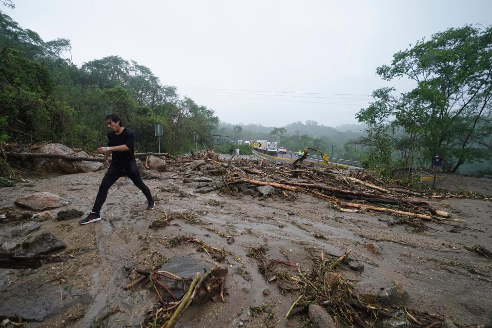
The hurricane left a trail of devastation, knocking over trees and flooding streets. The heavy flooding also triggered landslides in the resort city and left many parts of the state of Guerrero without power or cellphone service. Forecasts predicted up to 15 inches of rain in some areas.
The full extent of damages along with the number of potential injuries and deaths remains unclear due to communications disruptions and the main highway into Acapulco being impassable.
Videos on social media and television footage shared online Wednesday showed hotels, restaurants, streets and bridges to be mostly underwater. Large buildings and other structures had ripped off walls and roofs.
The storm moved inland and had dissipated by late Wednesday afternoon, the National Hurricane Center said. Some residual rain is likely across southwestern and south-central Mexico through Thursday, which could lead to more flooding and mudslides, the center said. The remnants of the storm pose no threat to the U.S.
Acapulco is a resort city and major seaport in Guerrero on the Pacific Coast of Mexico, about 240 miles south of Mexico City. Nearly 1 million people live in the city and hundreds of thousands of tourists visit each year.
The beach resort town was one of Mexico's top tourism destinations but an upsurge in organized crime groups and violence in recent years has attracted fewer foreign tourists.
From tropical storm to hurricane within hours
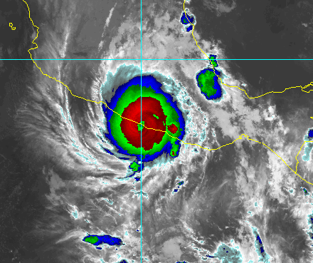
Otis blew up from a tropical storm with 70 mph winds to a Category 5 hurricane with 165 mph winds in just 13 hours, advisories from the hurricane center show.
It was the strongest Pacific hurricane on record to make landfall in Mexico, said Michael Lowry of WPLG in Miami.
Otis saw the fastest 12-hour intensification rate on record of any eastern Pacific hurricane in 57 years, breaking the previous record of 75 mph in 12 hours set by Hurricane Patricia in 2015, Phil Klotzbach, a Colorado State University research meteorologist, said on X, formerly Twitter.
None of the main forecast models showed that kind of rapid intensification, said Jeff Masters, of the multimedia service Yale Climate Connections. Masters is a former hurricane hunter meteorologist at the National Oceanic and Atmospheric Administration and founder of the Weather Underground.
Although the hurricane center's intensity forecasts warned rapid intensification was possible, the center had little guidance to show the storm would explode like it did, Masters said.
"They’re going to have to go back and figure out what went wrong, because rapidly intensifying hurricanes are the most dangerous kind because they don’t give you enough time to prepare and get people out of harm’s way," he said.
How do hurricane models work? Spaghetti models explained
Devastation in Acapulco
On the outskirts of Acapulco on Wednesday, highway workers looked on helplessly without the heavy machinery needed to clear debris from the roadway. They warned the road could give way at any time because of the rain-softened ground beneath. Bridges in some areas had collapsed, and trees leaned almost horizontally across the highway, not because they were uprooted, but because the earth they grew on had slid down the slope.
Earlier, as it made landfall near Acapulco Wednesday morning, Otis generated a dangerous storm surge and life-threatening waves, the hurricane center said.
Photos shared to social media showed heavy damage to the Galerias Diana mall in the beach resort city, where high winds ripped off a large section of the roof and water flooded surrounding streets.
Photos and video shared by Mexican news outlets from Acapulco after dawn showed the walls of buildings ripped off, flooded hotel rooms with collapsed ceilings, and rubble and downed trees lining the streets.
Videos from hotel guests in Acapulco posted to X, formerly known as Twitter, as the storm came ashore showed blinding horizontal rain and howling winds.
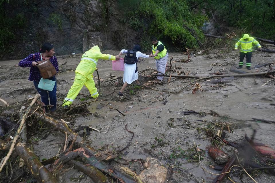
Mexican President Andrés Manuel López Obrador said in a news conference that the storm ruptured roads and caused landslides on the highway to Acapulco. He said damage to the local military airport restricted authorities from accessing the region.
Mexico’s Secretary of National Defense told The Associated Press on Wednesday that 7,000 military personnel had been deployed to the area, and that more than 1,200 more were on their way.
"Until now we have no data on loss of human life, but there is no communication. We do not know," he said.
Mexico has seen two of its four strongest storms in history to make landfall from the Pacific side in just a couple of weeks, Masters said. Lidia made landfall Oct. 10 near Puerto Vallarta as a Category 4 storm with 140 mph winds.
What caused Otis to rapidly intensify?
Several things contributed to the explosion in the storm's intensity, Masters said:
Warm waters of 85 to 86 degrees.
The small size of the storm: Hurricane-force winds extended out only 30 miles.
A "jet streak," or a portion of the overall jet stream where the winds are stronger.
The warm jet streak provided fast-moving winds aloft that acted to ventilate Otis, much like a draft can fan the flames of a fire, Masters said.
As the center of Otis lifted warm air aloft, the jet streak “was able to pull the air away and allowed even more warm, moist air to lift,” he said. As that water vapor condenses in a storm, it releases heat, and that heat powered the rapid intensification of Otis.
One reason the models missed the rapid intensification was the wind shear in the area, which typically can inhibit intensification, he said. Another was the lack of data available to the models because only one hurricane hunter flight entered Otis.

What is it with October storms?
Three of the biggest explosive intensifying storms in the Atlantic and Pacific basins have all occurred within about a one-week time span over mid to late October, said Brian McNoldy, a senior research associate at the Rosenstiel School of Marine, Atmospheric and Earth Science at the University of Miami. That includes Otis, Wilma in 2005 and Patricia in 2015.
The high ocean heat content at this time of year might be responsible, he said. “Even though the sea surface temperatures are starting to cool, the ocean heat content is still quite high.”
Other landfalling hurricanes with highest winds in Mexico
Hurricane | Year | Winds (in mph) | Ocean basin |
Janet | 1955 | 172.6 | Atlantic |
Dean | 2007 | 172.6 | Atlantic |
Anita | 1977 | 172.6 | Atlantic |
Otis | 2023 | 165 | Pacific |
Gilbert | 1988 | 160 | Atlantic |
Unnamed storm | 1880 | 150 | Atlantic |
Wilma | 2005 | 150 | Atlantic |
Patricia | 2015 | 150 | Pacific |
Beulah | 1967 | 150 | Atlantic |
Carmen | 1974 | 150 | Atlantic |
Contributing: The Associated Press
This article originally appeared on USA TODAY: Hurricane Otis strikes Acapulco as devastating Category 5 hurricane

