Hurricane season will likely get busier with up to 25 named storms, highest forecast ever
The already busy 2020 hurricane season will likely get more hectic.
Federal forecasters are predicting up to 25 named storms, the highest number ever forecast, pushing the season into extremely active territory. They may even run out of names in the 2020 hurricane list and may need to use letters in the Greek alphabet to name storms later this season.
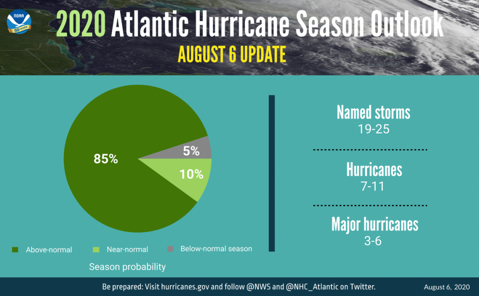
NOAA updated its forecast for named storms (winds of 39 mph or greater) to 19 to 25 in its annual mid-season outlook, compared with 13 to 19 in the first assessment announced in May. Seven to 11 storms are predicted to become hurricanes (winds of 74 mph or greater), with three to six of those forecast to become major hurricanes (winds of 111 mph or greater), NOAA said. That forecast takes into account the nine storms between May and July, including Hurricanes Hanna and Isaias. This latest update covers the entire six-month hurricane season, which ends Nov. 30.
“We’ve never forecast up to 25 named storms; this is the first time,” said Gerry Bell, lead hurricane season forecaster with NOAA’s Climate Prediction Center, in a media briefing on Thursday. “We now see a higher potential for this season to be considered as an extremely active season.” This is the highest prediction of named storms since 21 were forecast for the extremely active season of 2005, according to Bell. That season had 28 named storms.
Atmospheric conditions this year are growing more conducive to bigger storms, and a potential La Niña weather pattern could develop, adding even more power to storms forming in the Atlantic. Bell said warm ocean waters in the Atlantic, low wind shear, weaker trade winds and an active African monsoon season are creating the conditions for “one of the strongest hurricane seasons historically.”
NOAA issued a La Niña watch in early July, meaning the agency believed the weather pattern could form this season, making damaging storms more frequent and increasing the level of damage caused by each storm. During La Niña, westerly winds high in the atmosphere weaken, resulting in an expanded area of low vertical wind shear. That creates the conditions for more and stronger hurricanes to develop.
The agency in May predicted the formation of 13 to 19 named storms, six to 10 hurricanes and three to six major hurricanes.
The revised outlook echoed forecasts for an extremely active season announced Wednesday by hurricane experts at Colorado State University. The team predicted a total of 24 named storms in 2020, including the nine that have formed so far: Arthur, Bertha, Cristobal, Dolly, Edouard, Fay, Gonzalo, Hanna and Isaias.
The researchers predicted that 12 would become hurricanes. So far Hanna, which made landfall in Texas in July, and recently Isaias reached hurricane status. Isaias toggled between tropical storm and hurricane strength, skirting Florida’s East Coast on Aug. 2 before hitting the North Carolina coast the next day. At least nine deaths have been confirmed as heavy rainfall and storm surge hit the East Coast this week, leaving more than 2 million people without power.
“The team predicts that 2020 hurricane activity will be about 190% of the average season,” according to the researchers’ forecast. “By comparison, 2019’s hurricane activity was about 120% of the average season.”
An average storm season has 12 named storms, including six hurricanes and three major hurricanes, NOAA says.

