Hurricane season may turn ‘hyperactive' in eastern Pacific


 |
The countdown to the Pacific hurricane season has begun, but a group of AccuWeather meteorologists has long been examining the factors that could influence tropical activity in the ocean's east and central basins. Following a particularly unique season in 2022 that featured storms crossing over from the Atlantic and the closest approaching tropical system to San Diego since 1997, forecasters are warning at least one of the basins will see an above-average number of direct impacts.
The team, led by AccuWeather Hurricane Expert Dan Kottlowski, is forecasting an above-average season in the East Pacific basin with 17 to 21 named storms and an average season for the Central Pacific basin season with two to five named storms. The East Pacific season is slated to begin on May 15, while the Central Pacific season will get underway on June 1.
Of those storms, eight to 12 are forecast to become hurricanes in the Eastern Pacific - four to eight of which could become major hurricanes, or a Category 3 storm or stronger - and one to three are projected to become hurricanes in the Central Pacific. There is the possibility that two of the Central Pacific storms could intensify into major hurricanes.
While the Central Pacific didn't churn out any named storms in 2022, the last Eastern Pacific season featured 19 - well above the 30-year average of 15 named storms. Of the 19, 10 intensified into hurricanes, four of which turned into major hurricanes.
 |
The season also featured a few unique storms. Bonnie, for example, formed in the Atlantic but crossed over through the Central American country of Nicaragua before strengthening into a hurricane over the Pacific, becoming the first storm to survive the trek since Hurricane Otto in 2016. Hurricane Julia would later cross over from the Atlantic before swinging back toward the Central American coastline to make landfall in El Salvador.
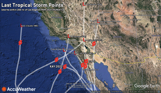
Hurricane Kay may be one of the first Pacific storms to come to mind for many in Southern California after the North American monsoon pulled some of its moisture northward. While the rain it brought aided firefighters in taming raging wildfires, it also triggered mudslides near burn scars. The storm also etched its name into the record books as the closest storm to approach San Diego by the ocean side since records began in 1949.
 |
Although many tropical storms have affected the Southwest, few have been officially tracked as close to Southern California as Tropical Storm Kay. |
However, before tracking near California, Kay made landfall as a hurricane in Mexico, making it one of the seven direct hits of the 2022 Eastern Pacific season.
AccuWeather forecasters anticipate this season could bring another above-average number of direct hits as it may turn out to be a particularly active season depending on how the El Niño-Southern Oscillation (ENSO) plays out.
ENSO is a short-term climate fluctuation determined by the warming or cooling of parts of the Pacific waters, but many know of it through the El Niño and La Niña patterns. The former of these two is synonymous with anomalously warm sea water surface temperatures in the eastern half of the equatorial Pacific while colder sea surface temperatures are typical during a La Niña.
After being in the La Niña phase for roughly two and a half years, ENSO is currently in a neutral phase - though there is a strong chance for El Niño to develop by late spring or early summer and, with it, a decrease in wind shear over critical portions of the Pacific.
"Tropical systems like to be vertically stacked. When it comes to their thunderstorms, they like to rise straight up into the atmosphere. When there's a lot of wind shear present, it knocks those thunderstorms over," AccuWeather Meteorologist Alex DaSilva said. "Think of it like a stack of pancakes. When there's a whole bunch of wind shear, it knocks those thunderstorms over and prevents really strong development of systems."
 |
The stronger the El Niño pattern, the less frequent the wind shear in the Pacific, allowing for more storms to pop up in the basin. Currently, AccuWeather forecasters are anticipating a weak to moderate El Niño pattern to arrive by the summer that may strengthen come fall.
In addition to the transitioning ENSO, a factor behind why California received so much rain and snow this winter may also play a role in tropical development in the Central Pacific.
"We've been seeing those cooler water temperatures along the west coast of California all the way to the east of Hawaii, and that's part of the reason why we've seen a lot of rain in California this winter is because of the cooler water temperatures," DaSilva said. "It's all connected."
The cold water filtering down from the U.S. West Coast is one of the primary concerns as to why AccuWeather forecasters say the Central Pacific will see an average number of storms while anticipating an above-average season in the Eastern Pacific as waters off of southwest Mexico warm up. Previous years with similar ENSO trends suggest an above-average chance for direct impacts in western Mexico and the Mexican state of Baja California, and forecasters say this season will see a similar level of risk.
AccuWeather is calling for four to eight direct impacts along the coasts of Mexico and Central America this season. Farther out in the Central Pacific, forecasters expect, at most, one storm to directly impact Hawaii, if any at all.
Kottlowski added that he was concerned the East Pacific could experience a "hyperactive" season, but forecasters said key indicators will become more certain in July.
To predict future hurricane seasons, forecasters often look to the past. Years that have similar climate and weather setups are called "analog years" and often offer some insight into what meteorologists can expect during an upcoming tropical season.
A few of the analog years analyzed by Kottlowski's team were particularly active seasons in the East Pacific Basin, including 2006, 2009, 2012, 2014 and 2018.
These years also featured a Pacific season where the ENSO was transitioning into an El Niño pattern and typically saw an increased number of storms in the basins, according to DaSilva.
 |
Boys look out at the sea as Hurricane John approached Wednesday, Aug. 30, 2006, in Barra de Navidad, Mexico. (AP Photo/Guillermo Arias) |
The analog year 2006 was the first above-average season since 1994, producing 19 named storms, 11 hurricanes, and six major hurricanes. Hurricane John, which struck Baja California on Sept. 1 as a high-end Category 2 hurricane, became the deadliest storm of the season. At its peak, John was a Category 4 hurricane.
Category 3 Hurricane Lane was another infamous storm from that year, causing millions of dollars worth of damages equal to millions of U.S. dollars to parts of Mexico.
In 2018, another analog year, 22 named storms were spawned in the Eastern Pacific, including 12 hurricanes. Nine of those hurricanes intensified into major hurricanes, and two even reached Category 5 strength. Meanwhile, in the Central Pacific, Category 5 Hurricane Walaka approached Hawaii. The storm weakened to a Category 3 hurricane before slamming the French Frigate Shoals, destroying the uninhabited East Island.
Five named storms, four of which were named in the Eastern Pacific before crossing into the Central Pacific, trekked near the islands in 2018, though only two made landfall. Hurricane Olivia made landfall in Maui as a tropical storm, wreaking havoc through flooding rainfall and gusty winds.
 |
This Monday, Oct. 1, 2018, photo provided by the U.S. Coast Guard shows a HC-130 Hercules aircraft approaching Johnston Atoll to evacuate four wildlife refuge workers before Hurricane Walaka arrived at the remote Pacific island. (Petty Officer 3rd Class Michael Griffin/U.S. Coast Guard via AP) |
Tropical systems frequently threatened western Mexico's shores during those years, DaSilva said. "And when you have warmer-than-average water temperatures in the Eastern and Central Pacific Basins due to El Niño, that increases your chances of having more systems make it close to Hawaii."
Cold waters east and northeast of Hawaii, even during the heart of the hurricane season, typically act as a barrier near the archipelago, deterring development and weakening the tropical systems that approach.
"When we see stronger systems impacting Hawaii, what typically happens is they actually move from east to west, and then they hook up north," DaSilva said. "And so they hit Hawaii moving north because the water temperatures to the south of Hawaii are plenty warm enough to support tropical development and tropical growth."
 |
FILE - In this Aug. 8, 2014, file photo, winds from Tropical Storm Iselle blow palm trees near a sign warning of the closure of Kualoa Regional Park in Honolulu. Residents on Hawaii’s southernmost island had already dealt with one tropical storm that year and were coping with the threat of encroaching lava. In addition to all this, meteorologists added that a tropical system was heading their way. (AP Photo/Eugene Tanner, File) |
The strongest and most damaging hurricane to the state since NHC records began is Hurricane Iniki, which passed south of the Big Island in September of 1992 before curving north while intensifying. The storm made landfall on the southern coast of Kauai near Waimea as a Category 4 hurricane on Sept. 11, only 18 days after Hurricane Andrew slammed Florida.
The latest tropical system to impact the islands was Hurricane Douglas, which passed north of Hawaii, in 2020. While it didn't make a direct strike, it was the closest hurricane to track near Oahu in National Hurricane Center (NHC) records and brought heavy rainfall and gusty winds to the archipelago.
 |
A Poipu Beach resort on the Hawaiian island of Kauai is heavily damaged following high winds and rain from Hurricane Iniki, Sept. 12, 1992. The island was without electricity and the airports are closed. (AP Photo/Reed Saxon) |
While there is still some time ahead of the official start of the Eastern and Central Pacific hurricane seasons, residents of hurricane-prone regions should devise a storm preparedness plan as soon as possible if they do not already have one. This plan should also include evacuation routes and nearby shelters.
It doesn't take a major hurricane to cause intense damage, as Hurricane Kay showed as it passed Southern California. The storm's moisture that was pulled into the Southwest was enough to cause life-threatening mudslides without a landfall in the region.
Want next-level safety, ad-free? Unlock advanced, hyperlocal severe weather alerts when you subscribe to Premium+ on the AccuWeather app. AccuWeather Alerts™ are prompted by our expert meteorologists who monitor and analyze dangerous weather risks 24/7 to keep you and your family safer.
